Comparing Groundwater Storage Changes in Two Main Grain Producing Areas in China: Implications for Sustainable Agricultural Water Resources Management


Abstract
:
1. Introduction
2. Data and Methods
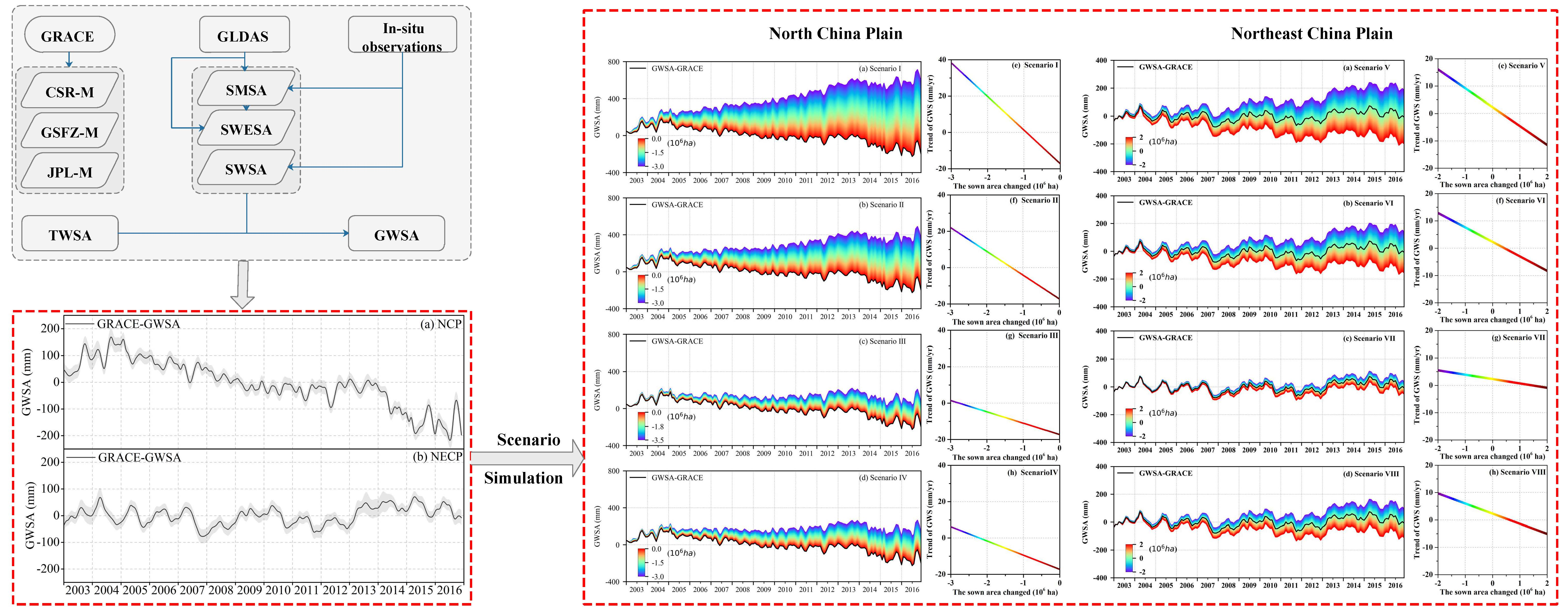
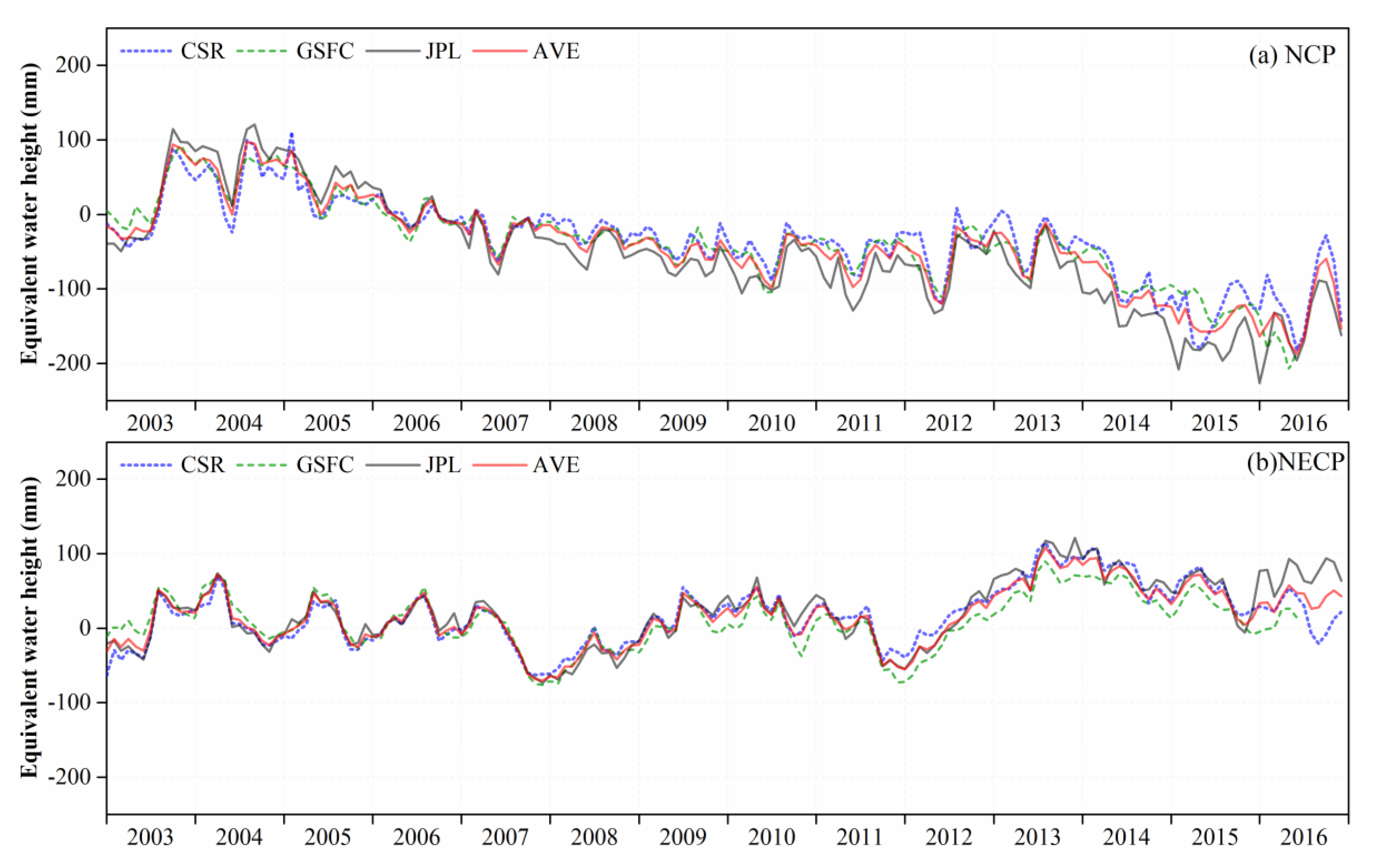
2.1. GRACE-Derived TWSA
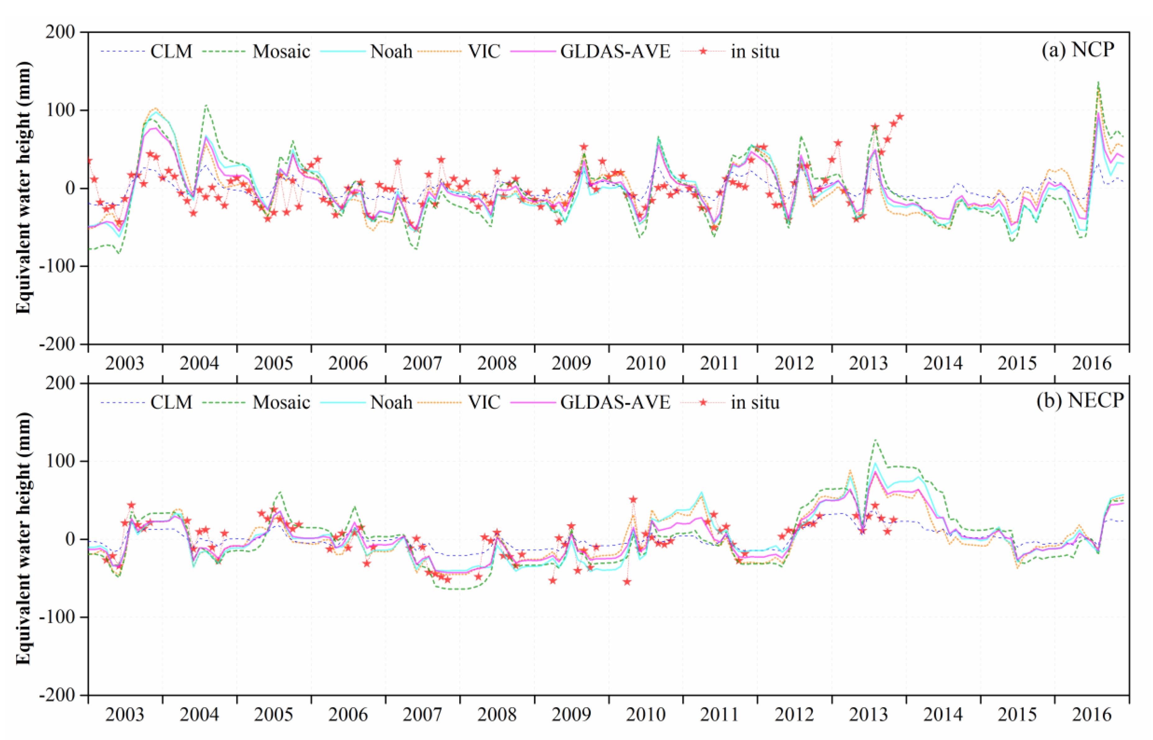
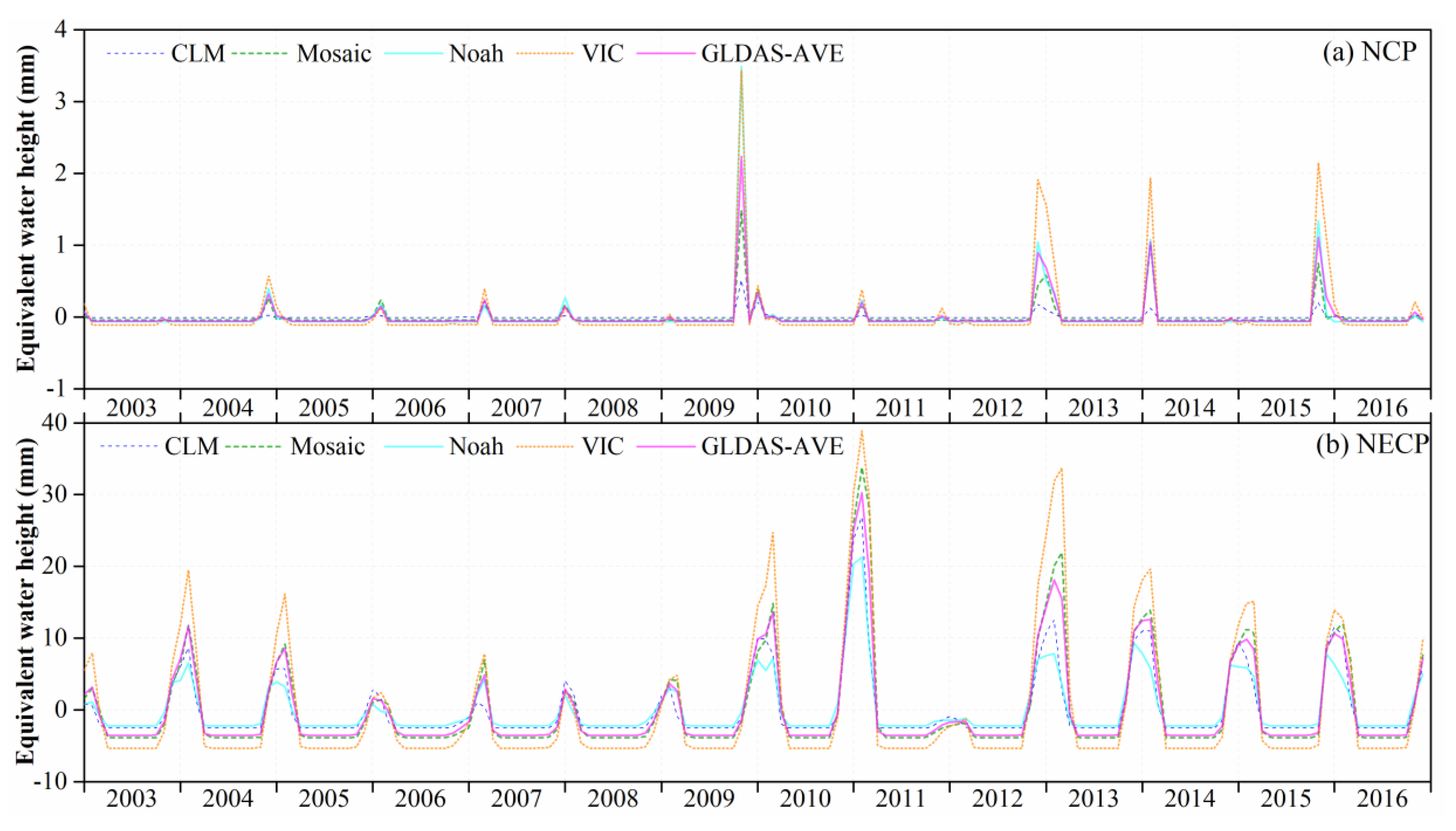
2.2. SMSA and SWESA
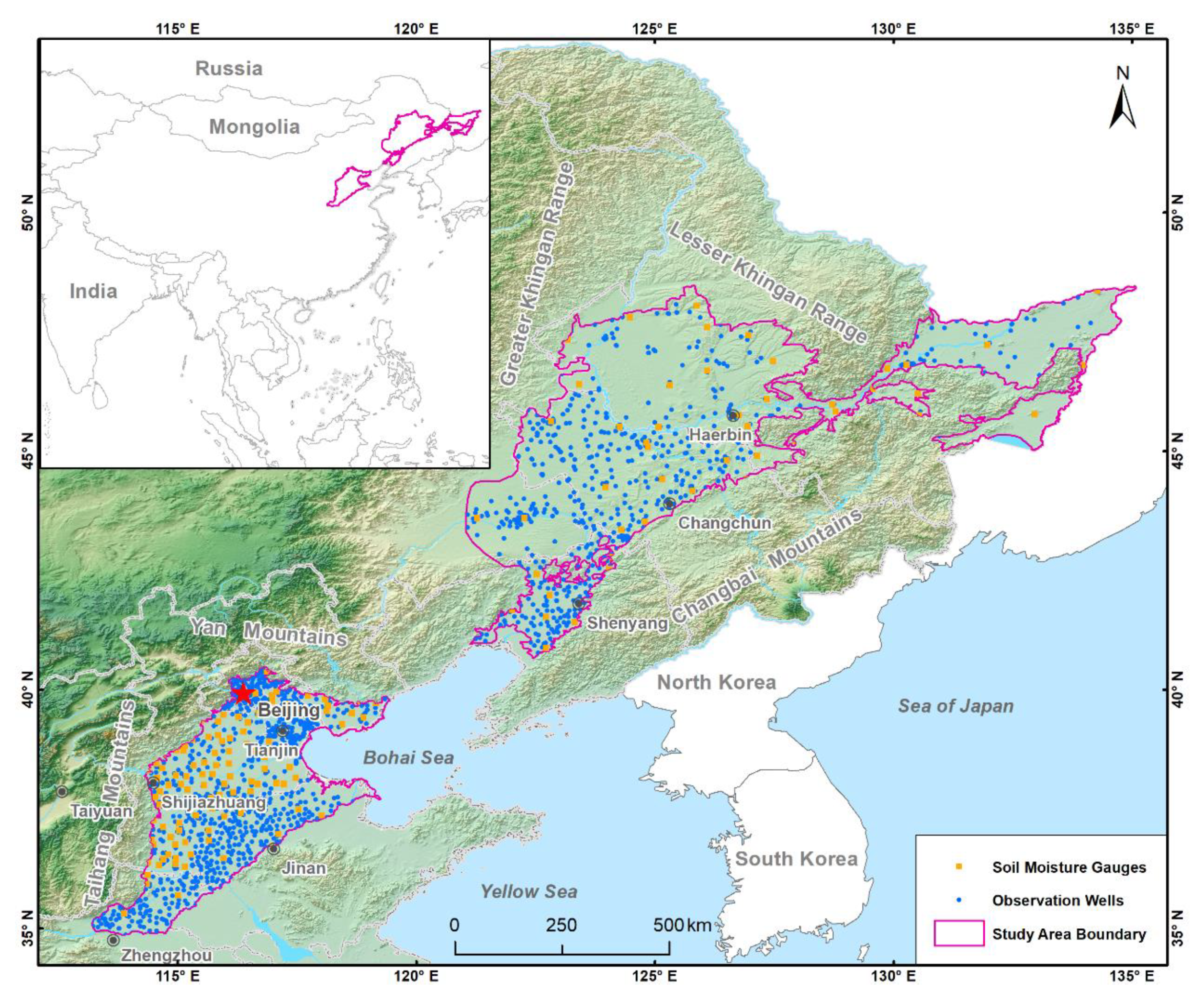
2.3. In Situ SWSA
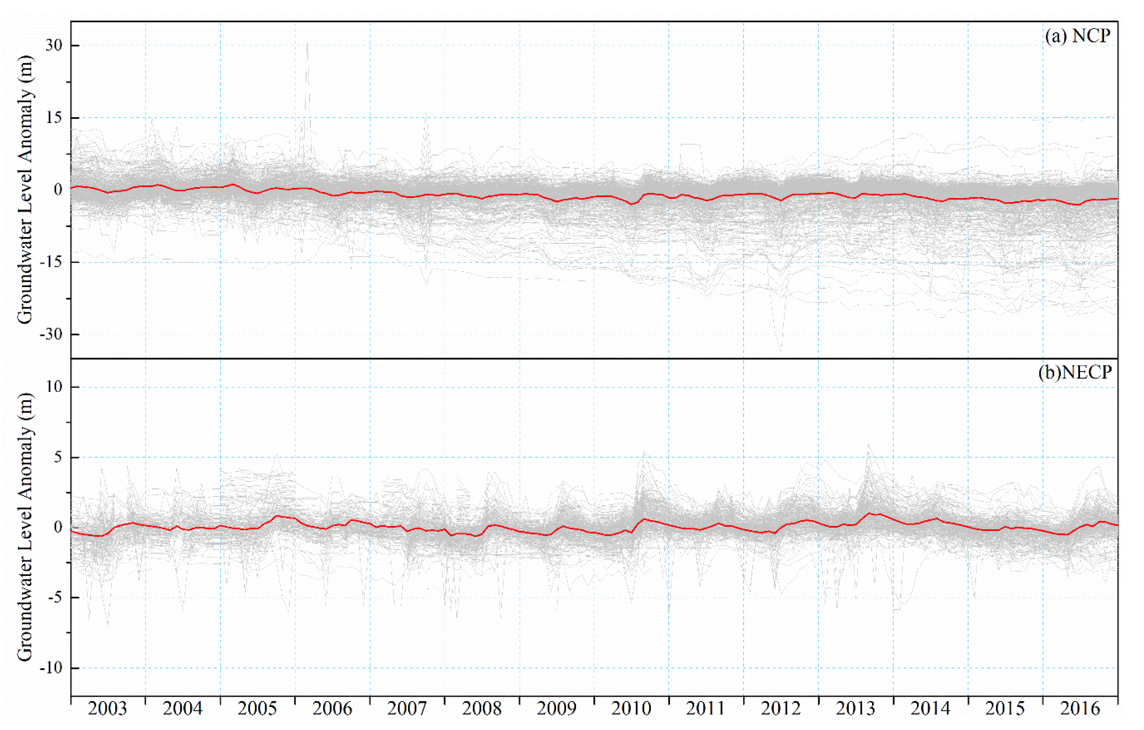
2.4. In Situ GWL Observations
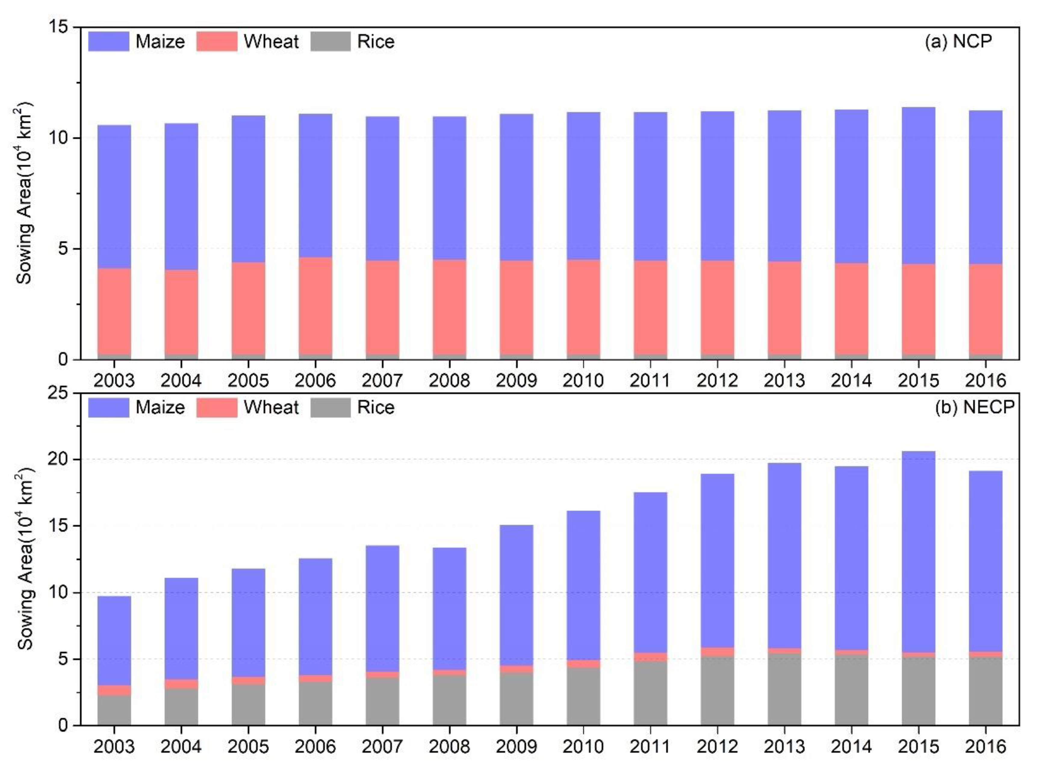
2.5. Sown Area of Main Grain Crops
2.6. Auxiliary Data
2.7. Irrigation Area Scenario Simulation Settings
2.8. Uncertainty Estimation
3. Results
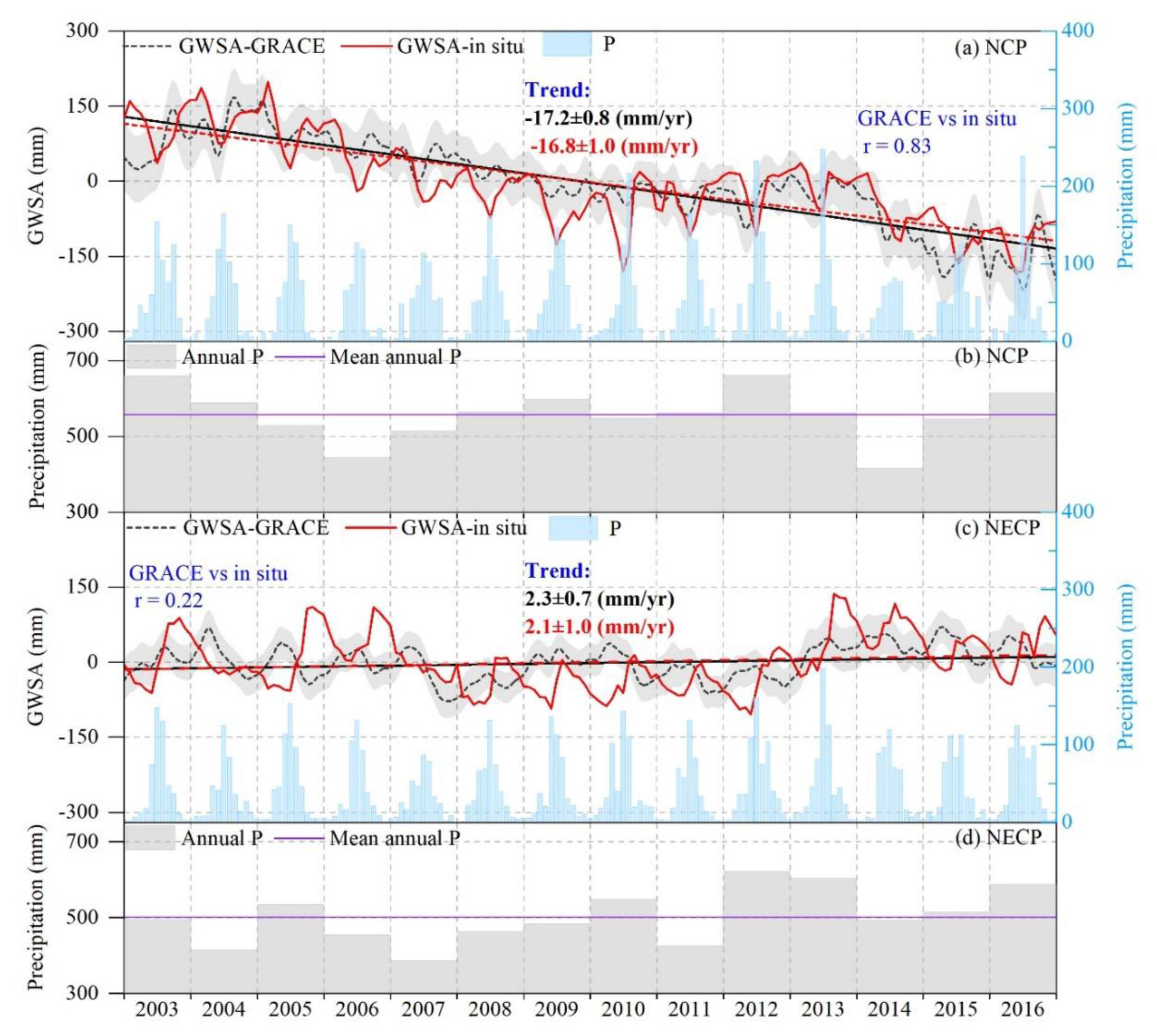
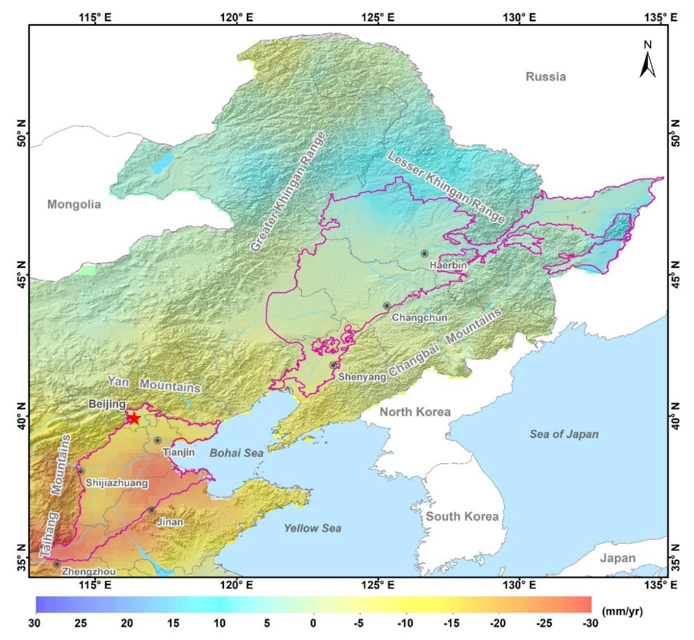
3.1. Groundwater Storage Changes Monitored by GRACE
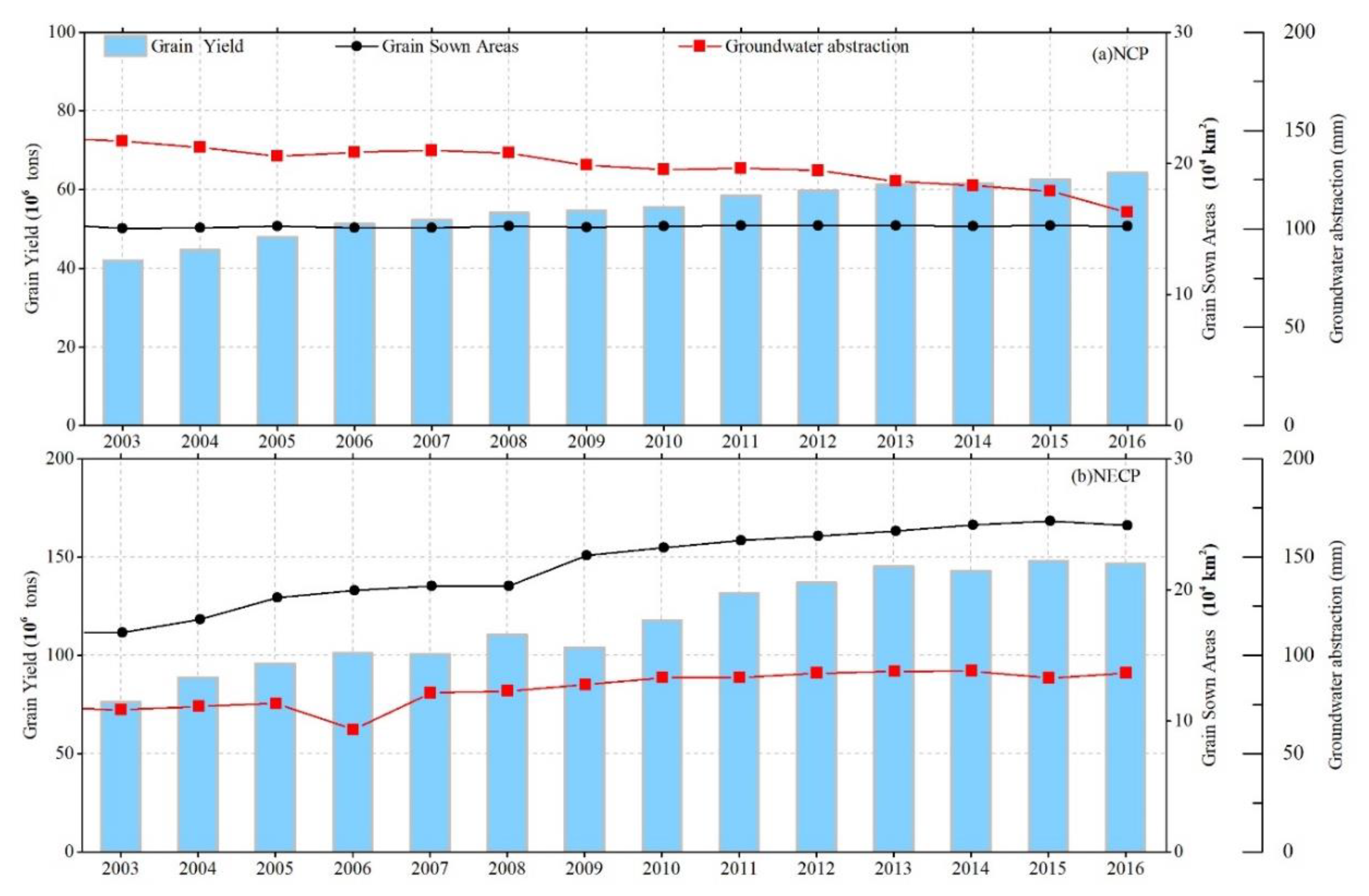
3.2. Long-Term Groundwater Abstraction Variations and Grain Production
4. Discussion
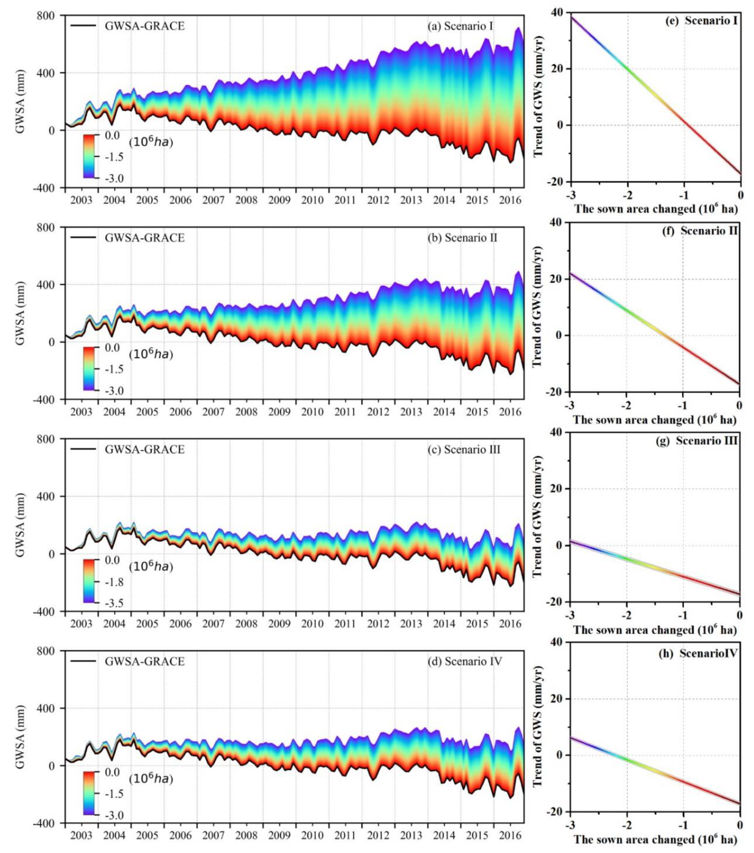
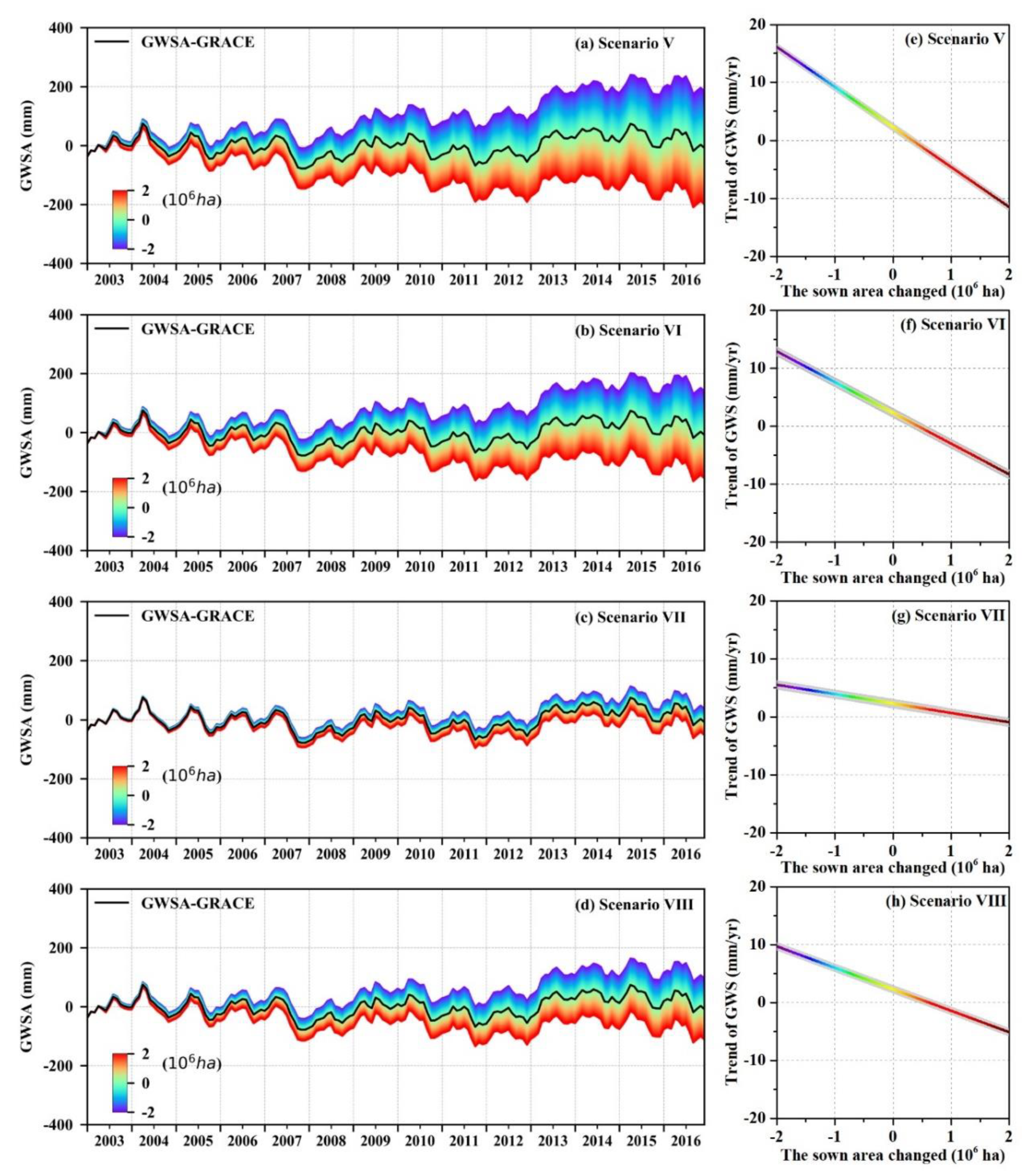
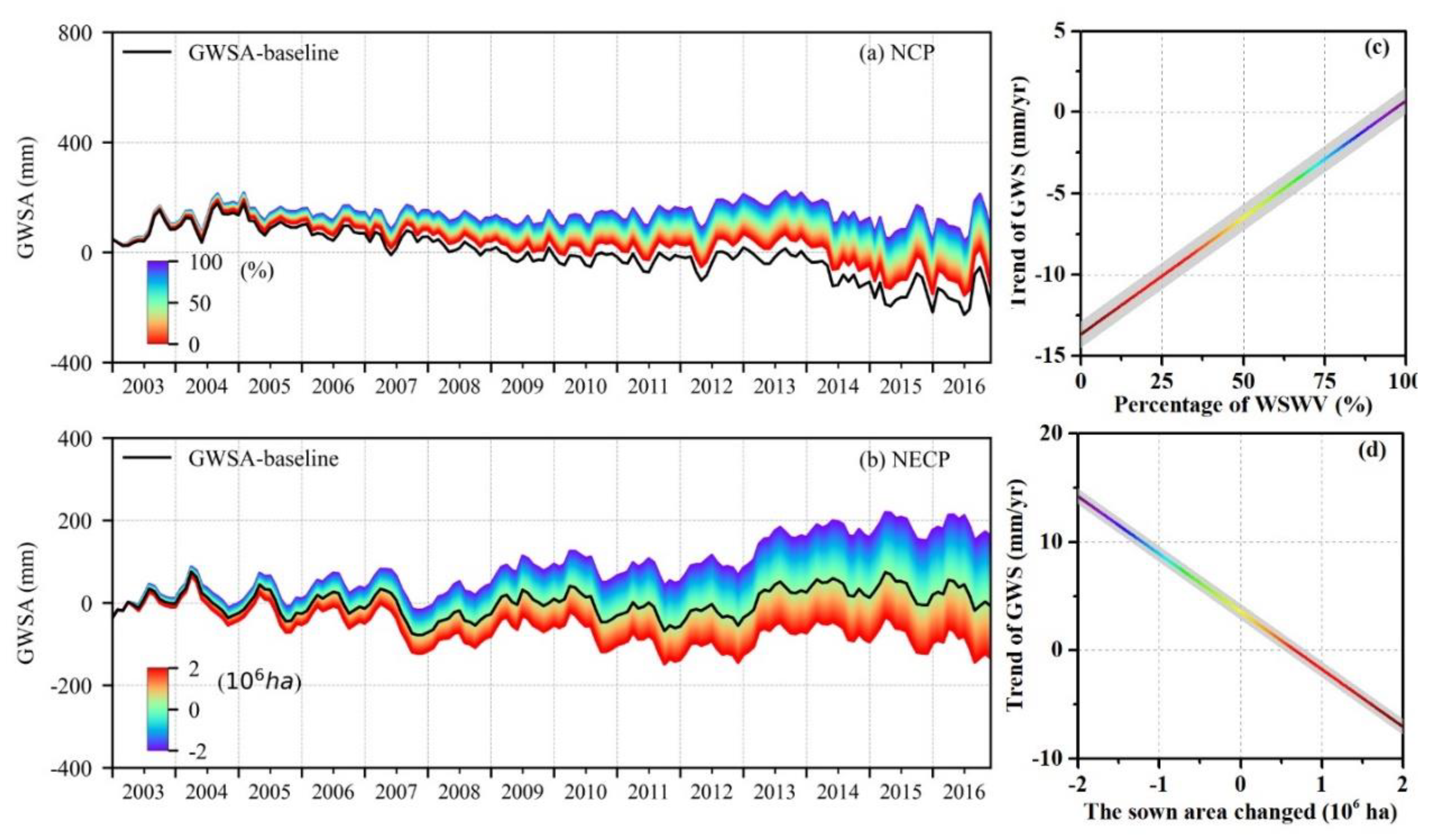
4.1. The Projected GWSA under Different Scenarios
4.2. Evaluation of Policies on Recovering GWS in the NCP
4.3. Uncertainties
5. Conclusions
Author Contributions
Funding
Acknowledgments
Conflicts of Interest
References
- Aeschbach-Hertig, W.; Gleeson, T. Regional strategies for the accelerating global problem of groundwater depletion. Nat. Geosci. 2012, 5, 853–861. [Google Scholar] [CrossRef]
- WWAP. The United Nations World Water Development Report 4: Managing Water under Uncertainty and Risk; UNESCO: Paris, France, 2012. [Google Scholar]
- Giordano, M. Global Groundwater? Issues and Solutions. Annu. Rev. Env. Resour. 2009, 34, 153–178. [Google Scholar] [CrossRef]
- Hanasaki, N.; Kanae, S.; Oki, T.; Masuda, K.; Motoya, K.; Shirakawa, N.; Shen, Y.; Tanaka, K. An integrated model for the assessment of global water resources—Part 2: Applications and assessments. Hydrol. Earth Syst. Sci. Hydrol. 2008, 12, 1027–1037. [Google Scholar] [CrossRef] [Green Version]
- Shen, Y.; Zhang, Y.; Scanlon, B.R.; Lei, H.; Yang, D.; Yang, F. Energy/water budgets and productivity of the typical croplands irrigated with groundwater and surface water in the North China Plain. Agric. For. Meteorol. 2013, 181, 133–142. [Google Scholar] [CrossRef]
- Sun, H.; Shen, Y.; Yu, Q.; Flerchinger, G.N.; Zhang, Y.; Liu, C.; Zhang, X. Effect of precipitation change on water balance and WUE of the winter wheat–summer maize rotation in the North China Plain. Agric. Water Manag. 2010, 97, 1139–1145. [Google Scholar] [CrossRef]
- Feng, W.; Zhong, M.; Lemoine, J.; Biancale, R.; Hsu, H.; Xia, J. Evaluation of groundwater depletion in North China using the Gravity Recovery and Climate Experiment (GRACE) data and ground-based measurements. Water Resour. Res. 2013, 49, 2110–2118. [Google Scholar] [CrossRef]
- Huang, Z.; Pan, Y.; Gong, H.; Yeh, P.J.F.; Li, X.; Zhou, D.; Zhao, W. Subregional-scale groundwater depletion detected by GRACE for both shallow and deep aquifers in North China Plain. Geophys. Res. Lett. 2015, 42, 1791–1799. [Google Scholar] [CrossRef]
- Min, L.; Shen, Y.; Pei, H. Estimating groundwater recharge using deep vadose zone data under typical irrigated cropland in the piedmont region of the North China Plain. J. Hydrol. 2015, 527, 305–315. [Google Scholar] [CrossRef]
- Xu, Y.; Mo, X.; Cai, Y.; Li, X. Analysis on groundwater table drawdown by land use and the quest for sustainable water use in the Hebei Plain in China. Agric. Water Manag. 2005, 75, 38–53. [Google Scholar] [CrossRef]
- Min, L.; Qi, Y.; Shen, Y.; Wang, P.; Wang, S.; Liu, M. Groundwater recharge under irrigated agro-ecosystems in the North China Plain: From a critical zone perspective. J. Geogr. Sci. 2019, 29, 877–890. [Google Scholar] [CrossRef] [Green Version]
- Wu, X.; Qi, Y.; Shen, Y.; Yang, W.; Zhang, Y.; Kondoh, A. Change of winter wheat planting area and its impacts on groundwater depletion in the North China Plain. J. Geogr. Sci. 2019, 29, 891–908. [Google Scholar] [CrossRef] [Green Version]
- Wang, X.; Li, X.; Xin, L. Impact of the shrinking winter wheat sown area on agricultural water consumption in the Hebei Plain. J. Geogr. Sci. 2014, 24, 313–330. [Google Scholar] [CrossRef]
- Pei, H.; Scanlon, B.R.; Shen, Y.; Reedy, R.C.; Long, D.; Liu, C. Impacts of varying agricultural intensification on crop yield and groundwater resources: Comparison of the North China Plain and US High Plains. Environ. Res. Lett. 2015, 10, 44013. [Google Scholar] [CrossRef] [Green Version]
- Sun, Q.; Kröbel, R.; Müller, T.; Römheld, V.; Cui, Z.; Zhang, F.; Chen, X. Optimization of yield and water-use of different cropping systems for sustainable groundwater use in North China Plain. Agric. Water Manag. 2011, 98, 808–814. [Google Scholar] [CrossRef]
- Zhang, X.; Chen, S.; Liu, M.; Pei, D.; Sun, H. Improved water use efficiency associated with cultivars and agronomic management in the North China Plain. Agron. J. 2005, 97, 783–790. [Google Scholar] [CrossRef]
- Li, Y.; Zhang, W.; Ma, L.; Wu, L.; Shen, J.; Davies, W.J.; Oenema, O.; Zhang, F.; Dou, Z. An analysis of China’s grain production: Looking back and looking forward. Food Energy Secur. 2014, 3, 19–32. [Google Scholar] [CrossRef]
- Cao, G.; Scanlon, B.R.; Han, D.; Zheng, C. Impacts of thickening unsaturated zone on groundwater recharge in the North China Plain. J. Hydrol. 2016, 537, 260–270. [Google Scholar] [CrossRef]
- Xiao, D.; Shen, Y.; Qi, Y.; Moiwo, J.P.; Min, L.; Zhang, Y.; Guo, Y.; Pei, H. Impact of alternative cropping systems on groundwater use and grain yields in the North China Plain Region. Agric. Syst. 2017, 153, 109–117. [Google Scholar] [CrossRef]
- Li, P.; Ren, L. Evaluating the effects of limited irrigation on crop water productivity and reducing deep groundwater exploitation in the North China Plain using an agro-hydrological model: II. Scenario simulation and analysis. J. Hydrol. 2019, 574, 715–732. [Google Scholar] [CrossRef]
- Li, P.; Ren, L. Evaluating the effects of limited irrigation on crop water productivity and reducing deep groundwater exploitation in the North China Plain using an agro-hydrological model: I. Parameter sensitivity analysis, calibration and model validation. J. Hydrol. 2019, 574, 497–516. [Google Scholar] [CrossRef]
- Ren, X. Water Resources Assessment of the Haihe River Basin; China Water Power Press: Beijing, China, 2007. [Google Scholar]
- Cao, G.; Zheng, C.; Scanlon, B.R.; Liu, J.; Li, W. Use of flow modeling to assess sustainability of groundwater resources in the North China Plain. Water Resour. Res. 2013, 49, 159–175. [Google Scholar] [CrossRef]
- Water Resources Protection Bureau of Songliao River Basin; Bulletin of Water Resources in Songliao River Basin: Changchun, China, 2003.
- Pan, Y.; Zhang, C.; Gong, H.; Yeh, P.J.F.; Shen, Y.; Guo, Y.; Huang, Z.; Li, X. Detection of human-induced evapotranspiration using GRACE satellite observations in the Haihe River basin of China. Geophys. Res. Lett. 2017, 44, 190–199. [Google Scholar] [CrossRef]
- Gong, H.; Pan, Y.; Zheng, L.; Li, X.; Zhu, L.; Zhang, C.; Huang, Z.; Li, Z.; Wang, H.; Zhou, C. Long-term groundwater storage changes and land subsidence development in the North China Plain (1971–2015). Hydrogeol. J. 2018, 26, 1417–1427. [Google Scholar] [CrossRef] [Green Version]
- Zhong, Y.; Zhong, M.; Feng, W.; Zhang, Z.; Shen, Y.; Wu, D. Groundwater Depletion in the West Liaohe River Basin, China and Its Implications Revealed by GRACE and In Situ Measurements. Remote Sens. 2018, 10, 493. [Google Scholar] [CrossRef] [Green Version]
- Chen, H.; Zhang, W.; Nie, N.; Guo, Y. Long-term groundwater storage variations estimated in the Songhua River Basin by using GRACE products, land surface models, and in-situ observations. Sci. Total Environ. 2019, 649, 372–387. [Google Scholar] [CrossRef]
- Famiglietti, J.S.; Lo, M.; Ho, S.L.; Bethune, J.; Anderson, K.J.; Syed, T.H.; Swenson, S.C.; de Linage, C.R.; Rodell, M. Satellites measure recent rates of groundwater depletion in California’s Central Valley. Geophys. Res. Lett. 2011. [Google Scholar] [CrossRef] [Green Version]
- Tapley, B.D.; Bettadpur, S.; Ries, J.C.; Thompson, P.F.; Watkins, M.M. GRACE Measurements of Mass Variability in the Earth System. Science 2004, 305, 503–505. [Google Scholar] [CrossRef] [Green Version]
- Wahr, J.; Swenson, S.; Zlotnicki, V.; Velicogna, I. Time-variable gravity from GRACE: First results. Geophys. Res. Lett. 2004. [Google Scholar] [CrossRef] [Green Version]
- Wahr, J.; Molenaar, M.; Bryan, F. Time variability of the Earth’s gravity field: Hydrological and oceanic effects and their possible detection using GRACE. J. Geophys. Res. Solid Earth 1998, 103, 30205–30229. [Google Scholar] [CrossRef]
- Swenson, S.; Wahr, J. Methods for inferring regional surface-mass anomalies from Gravity Recovery and Climate Experiment (GRACE) measurements of time-variable gravity. J. Geophys. Res. Solid Earth 2002, 107, 1–3. [Google Scholar] [CrossRef] [Green Version]
- Rodell, M.; Chen, J.; Kato, H.; Famiglietti, J.S.; Nigro, J.; Wilson, C.R. Estimating groundwater storage changes in the Mississippi River basin (USA) using GRACE. Hydrogeol. J. 2007, 15, 159–166. [Google Scholar] [CrossRef]
- Swenson, S.; Famiglietti, J.; Basara, J.; Wahr, J. Estimating profile soil moisture and groundwater variations using GRACE and Oklahoma Mesonet soil moisture data. Water Resour. Res. 2008. [Google Scholar] [CrossRef] [Green Version]
- Rodell, M.; Velicogna, I.; Famiglietti, J.S. Satellite-based estimates of groundwater depletion in India. Nature 2009, 460, 999–1002. [Google Scholar] [CrossRef] [PubMed] [Green Version]
- Scanlon, B.R.; Longuevergne, L.; Long, D. Ground referencing GRACE satellite estimates of groundwater storage changes in the California Central Valley, USA. Water Resour. Res. 2012. [Google Scholar] [CrossRef] [Green Version]
- Chen, J.; Li, J.; Zhang, Z.; Ni, S. Long-term groundwater variations in Northwest India from satellite gravity measurements. Glob. Planet. Chang. 2014, 116, 130–138. [Google Scholar] [CrossRef] [Green Version]
- Long, D.; Chen, X.; Scanlon, B.R.; Wada, Y.; Hong, Y.; Singh, V.P.; Chen, Y.; Wang, C.; Han, Z.; Yang, W. Have GRACE satellites overestimated groundwater depletion in the Northwest India Aquifer? Sci. Rep. 2016, 6, 24398. [Google Scholar] [CrossRef]
- Scanlon, B.R.; Faunt, C.C.; Longuevergne, L.; Reedy, R.C.; Alley, W.M.; McGuire, V.L.; McMahon, P.B. Groundwater depletion and sustainability of irrigation in the US High Plains and Central Valley. Proc. Natl. Acad. Sci. USA 2012, 109, 9320–9325. [Google Scholar] [CrossRef] [Green Version]
- Xiao, M.; Koppa, A.; Mekonnen, Z.; Pagán, B.R.; Zhan, S.; Cao, Q.; Aierken, A.; Lee, H.; Lettenmaier, D.P. How much groundwater did California’s Central Valley lose during the 2012–2016 drought? Geophys. Res. Lett. 2017, 44, 4872–4879. [Google Scholar] [CrossRef]
- Moiwo, J.P.; Yang, Y.; Han, S.; Lu, W.; Yan, N.; Wu, B. A method for estimating soil moisture storage in regions under water stress and storage depletion: A case study of Hai River Basin, North China. Hydrol. Process. 2011, 25, 2275–2287. [Google Scholar] [CrossRef]
- Yeh, P.J.F.; Swenson, S.C.; Famiglietti, J.S.; Rodell, M. Remote sensing of groundwater storage changes in Illinois using the Gravity Recovery and Climate Experiment (GRACE). Water Resour. Res. 2006. [Google Scholar] [CrossRef]
- Save, H.; Bettadpur, S.; Tapley, B.D. High-resolution CSR GRACE RL05 mascons. J. Geophys. Res. Solid Earth 2016, 121, 7547–7569. [Google Scholar] [CrossRef]
- Save, H. CSR GRACE RL06 Mascon Solutions. Available online: https://dataverse.tdl.org/dataset.xhtml?persistentId=doi:10.18738/T8/UN91VR (accessed on 20 May 2020).
- Luthcke, S.B.; Sabaka, T.J.; Loomis, B.D.; Arendt, A.A.; McCarthy, J.J.; Camp, J. Antarctica, Greenland and Gulf of Alaska land-ice evolution from an iterated GRACE global mascon solution. J. Glaciol. 2013, 59, 613–631. [Google Scholar] [CrossRef]
- Wiese, D.N.; Landerer, F.W.; Watkins, M.M. Quantifying and reducing leakage errors in the JPL RL05M GRACE mascon solution. Water Resour. Res. 2016, 52, 7490–7502. [Google Scholar] [CrossRef]
- Cheng, M.; Ries, J.C.; Tapley, B.D. Variations of the Earth’s figure axis from satellite laser ranging and GRACE. J.Geophys. Res. 2011. [Google Scholar] [CrossRef] [Green Version]
- Swenson, S.; Chambers, D.; Wahr, J. Estimating geocenter variations from a combination of GRACE and ocean model output. J. Geophys. Res. Solid Earth 2008. [Google Scholar] [CrossRef] [Green Version]
- Richard Peltier, W.; Argus, D.F.; Drummond, R. Comment on “An Assessment of the ICE-6G_C (VM5a) Glacial Isostatic Adjustment Model” by Purcell et al. J. Geophys. Res. Solid Earth 2018, 123, 2019–2028. [Google Scholar] [CrossRef]
- Watkins, M.M.; Wiese, D.N.; Yuan, D.; Boening, C.; Landerer, F.W. Improved methods for observing Earth’s time variable mass distribution with GRACE using spherical cap mascons. J. Geophys. Res. Solid Earth 2015, 120, 2648–2671. [Google Scholar] [CrossRef]
- Voss, K.A.; Famiglietti, J.S.; Lo, M.; de Linage, C.; Rodell, M.; Swenson, S.C. Groundwater depletion in the Middle East from GRACE with implications for transboundary water management in the Tigris-Euphrates-Western Iran region. Water Resour. Res. 2013, 49, 904–914. [Google Scholar] [CrossRef] [Green Version]
- Khaki, M.; Hoteit, I.; Kuhn, M.; Awange, J.; Forootan, E.; van Dijk, A.I.; Schumacher, M.; Pattiaratchi, C. Assessing sequential data assimilation techniques for integrating GRACE data into a hydrological model. Adv. Water Resour. 2017, 107, 301–316. [Google Scholar] [CrossRef] [Green Version]
- Rodell, M. The global land data assimilation system. Bull. Am. Meteorol. Soc. 2004, 85, 381–394. [Google Scholar] [CrossRef] [Green Version]
- Qiu, S.; Liang, X.; Xiao, C.; Huang, H.; Fang, Z.; Lv, F. Numerical Simulation of Groundwater Flow in a River Valley Basin in Jilin Urban Area, China. Water 2015, 7, 5768–5787. [Google Scholar] [CrossRef] [Green Version]
- Nie, T.; Zhang, Z.; Lin, Y.; Chen, P.; Sun, Z. Spatial and Temporal Distribution Characteristics of Maize Water Requirement in Heilongjiang Province during 1959–2015. Trans. Chin. Soc. Agric. Mach. 2018, 49, 217–227. (In Chinese) [Google Scholar]
- Huang, Z.; Wang, X.; Xiao, Y.; Yang, F.; Wang, C. Effect of climate change on rice irrigation water requirement in Songnen Plain, Northeast China. Chin. J. Appl. Ecol. 2015, 26, 260–268. (In Chinese) [Google Scholar]
- Nie, T.; Zhang, Z.; Qi, Z.; Chen, P.; Lin, Y.; Sun, Z. Spatial and Temporal Distribution Characteristics of Rice Water Requirement in Heilongjiang Province during 1960–2015. Trans. Chin. Soc. Agric. Machin. 2019, 50, 279–290. (In Chinese) [Google Scholar]
- Zhang, Q. Research on Spatial and Temporal Variations of Maize Irrigation Water Requirement in Jilin Province. Master Thesis, Northeast Normal University, Changchun, China, 2014. (In Chinese). [Google Scholar]
- Rodell, M. Basin scale estimates of evapotranspiration using GRACE and other observations. Geophys. Res. Lett. 2004. [Google Scholar] [CrossRef] [Green Version]
- Hu, Y.; Moiwo, J.P.; Yang, Y.; Han, S.; Yang, Y. Agricultural water-saving and sustainable groundwater management in Shijiazhuang Irrigation District, North China Plain. J. Hydrol. 2010, 393, 219–232. [Google Scholar] [CrossRef]


| Region | Irrigated Crops | Probability of Precipitation | Mar | Apr | May | Jun | Jul | Aug | Sep | Oct | Nov |
|---|---|---|---|---|---|---|---|---|---|---|---|
| NCP | wheat (mm) | 75% | 75 | 75 | 95 | - | - | - | - | - | 75 |
| 25% | 75 | 75 | 95 | - | - | - | - | - | - | ||
| corn (mm) | 75% | - | - | - | 65 | 65 | - | - | - | - | |
| 25% | - | - | - | 65 | - | - | - | - | - | ||
| NECP | rice (mm) | 75% | - | - | 190 | 185 | 115 | 45 | 40 | - | - |
| 25% | - | - | 163 | 160 | 100 | 38 | 34 | - | - | ||
| corn (mm) | 75% | - | - | 12 | 50 | 50 | 30 | 30 | - | - | |
| 25% | - | - | 8 | 37 | 37 | 22 | 22 | - | - |
| Region | EWH Anomaly | Annual Amplitude (mm) | Annual Phase (°) | Semi-Annual Amplitude (mm) | Semi-Annual Phase (°) | Trend (mm/yr) |
|---|---|---|---|---|---|---|
| NCP | GWS (GRACE) | 23.20 | 275.67 | 14.21 | 72.31 | −17.2 ± 0.8 |
| GWS (in situ) | 40.00 | 339.81 | 20.69 | 99.15 | −16.8 ± 1.0 | |
| NECP | GWS (GRACE) | 25.55 | 102.14 | 1.25 | 348.61 | 2.3 ± 0.7 |
| GWS (in situ) | 39.73 | 253.74 | 2.58 | 44.13 | 2.1 ± 1.0 |
| Year | NCP | NECP | ||||||
|---|---|---|---|---|---|---|---|---|
| GY (106 t) | GSA (104 km2) | GWA (mm) | P (mm) | GY (106 t) | GSA (104 km2) | GWA (mm) | P (mm) | |
| 2003 | 42.00 | 15.05 | 144.64 | 660.45 | 76.31 | 16.75 | 72.23 | 494.53 |
| 2004 | 44.58 | 15.10 | 141.43 | 588.90 | 88.70 | 17.77 | 74.13 | 413.83 |
| 2005 | 47.87 | 15.20 | 136.93 | 529.17 | 95.89 | 19.40 | 75.52 | 533.85 |
| 2006 | 51.33 | 15.09 | 139.07 | 443.03 | 101.04 | 19.96 | 62.25 | 454.85 |
| 2007 | 52.22 | 15.06 | 139.81 | 514.17 | 100.66 | 20.28 | 80.94 | 385.61 |
| 2008 | 54.10 | 15.19 | 138.63 | 564.67 | 110.57 | 20.28 | 81.89 | 463.09 |
| 2009 | 54.65 | 15.15 | 132.40 | 597.85 | 103.86 | 22.61 | 85.11 | 483.00 |
| 2010 | 55.56 | 15.19 | 130.32 | 548.05 | 117.79 | 23.23 | 88.66 | 547.98 |
| 2011 | 58.46 | 15.27 | 130.79 | 562.45 | 131.65 | 23.74 | 88.57 | 425.36 |
| 2012 | 59.74 | 15.27 | 129.65 | 661.29 | 137.03 | 24.12 | 90.94 | 621.45 |
| 2013 | 61.30 | 15.26 | 124.19 | 562.17 | 145.24 | 24.47 | 91.89 | 604.29 |
| 2014 | 61.59 | 15.23 | 122.12 | 414.69 | 142.82 | 24.96 | 92.07 | 492.90 |
| 2015 | 62.59 | 15.25 | 119.20 | 546.76 | 148.01 | 25.23 | 88.43 | 514.53 |
| 2016 | 64.19 | 15.20 | 108.42 | 615.88 | 146.57 | 24.91 | 91.06 | 589.48 |
| Region | TWSA (mm) | SMSA (mm) | SWESA (mm) | SWSA (mm) | GWSA (mm) |
|---|---|---|---|---|---|
| NCP | 50.50 | 12.41 | 0.07 | 0.73 | 52.01 |
| NECP | 32.71 | 10.55 | 1.70 | 2.11 | 34.48 |
| NCP | GWSA (mm) | Scenario Ⅰ | Scenario Ⅱ | Scenario Ⅲ | Scenario Ⅳ | Scenario FYAP |
| 53.31 | 52.97 | 52.59 | 53.31 | 52.45 | ||
| NECP | GWSA (mm) | Scenario Ⅴ | Scenario Ⅵ | Scenario Ⅶ | Scenario Ⅷ | Scenario SSSR |
| 35.00 | 34.97 | 34.94 | 34.95 | 35.04 |
© 2020 by the authors. Licensee MDPI, Basel, Switzerland. This article is an open access article distributed under the terms and conditions of the Creative Commons Attribution (CC BY) license (http://creativecommons.org/licenses/by/4.0/).
Share and Cite
Zheng, L.; Pan, Y.; Gong, H.; Huang, Z.; Zhang, C. Comparing Groundwater Storage Changes in Two Main Grain Producing Areas in China: Implications for Sustainable Agricultural Water Resources Management. Remote Sens. 2020, 12, 2151. https://doi.org/10.3390/rs12132151
Zheng L, Pan Y, Gong H, Huang Z, Zhang C. Comparing Groundwater Storage Changes in Two Main Grain Producing Areas in China: Implications for Sustainable Agricultural Water Resources Management. Remote Sensing. 2020; 12(13):2151. https://doi.org/10.3390/rs12132151
Chicago/Turabian StyleZheng, Longqun, Yun Pan, Huili Gong, Zhiyong Huang, and Chong Zhang. 2020. "Comparing Groundwater Storage Changes in Two Main Grain Producing Areas in China: Implications for Sustainable Agricultural Water Resources Management" Remote Sensing 12, no. 13: 2151. https://doi.org/10.3390/rs12132151