
Village Evaluation and Classification Guidance of a County in Southeast Gansu Based on the Rural Revitalization Strategy


1
Urban Development Research Institute of Gansu, Lanzhou City University, Lanzhou 730070, China
2
The Center for Modern Chinese City Studies & Institute of Urban Development, East China Normal University, Shanghai 200062, China
*
Author to whom correspondence should be addressed.
Land 2022, 11(6), 857; https://doi.org/10.3390/land11060857
Submission received: 29 April 2022
/
Revised: 2 June 2022
/
Accepted: 4 June 2022
/
Published: 7 June 2022
(This article belongs to the Special Issue Territory Spatial Planning toward High-Quality Development in China)
Abstract
:The rural revitalization strategy is a key strategic deployment to resolve the “San Nong” (Agriculture, Rural Areas, and Farmers) issue and attain agricultural and rural modernization in the new era. The strategy has practical significance in determining the differentiation principle of rural areas, identifying their development types, and elucidating the goal orientation of rural revitalization. Starting from the current situation of villages in Gangu County, this study thoroughly analyzes and evaluates the functions of the village system using the ArcGIS spatial analysis method, with urban–rural overall planning as the core concept and various function and correcting factor evaluations as the basis. Based on the functional characteristics of different dimensions, villages in Gangu County were categorized as follows: Weihe River Valley high-efficiency economic zone, Sandu River Taiwan grain and vegetable multi-characteristic economic zone, North Front Mountain grain, vegetable, medicine, and oil zone, South Front Mountain grain, vegetable, and oil zone, North Back Mountain grain, oil, and medicine zone, and South Back Mountain grain and economic zone as corresponding planning strategies for classified development guidance.
1. Introduction
Owing to limitations of natural endowment, the endogenous development motivation of most villages in China is inadequate. Meanwhile, the urban planning and construction preference of urban areas over rural areas has led to a disconnection between them, making it challenging to create a rural planning system. Hence, rural areas have long been in a state of sluggish and unproductive development. Even today, village planning is traditionally done under the influence of urban planning, generally overlooking the corresponding issues and failing to fulfill the developmental needs of villages. Consequently, many village planning projects face issues such as “not down to earth” and “not acclimated to the local place.” The recent Central Document No. 1 focuses on “San Nong” (Agriculture, Rural Areas, and Farmers), and the rural revitalization strategy has taken the reform, development, and planning of rural areas to a higher level. Foreign research on regional village layout planning is relatively mature. Regarding village layout and planning, some studies focused on the rural development and renewal plan [1,2]. The action “Our village should be more beautiful” published around 1980 in the context of urban and rural development in Germany in the last century primarily aimed to improve and optimize the land use structure in rural areas and guide villages to retain their traditional settlement spatial structure and rural features. In addition, it proposed specific strategies to improve agricultural production efficiency and guide the characteristic development of rural industry [3,4]. Meanwhile, Germany further proposed the relevant policy of “land consolidation” in rural areas to guide the conversion of extensive use of arable land into other lands, optimize and enhance the facilities within the village, and improve the level of the village human settlement environment [5]. Moreover, some studies presented a detailed study of the development and evolution of American rural settlements in the past 20 years, proposing that the land use of the rural settlement of Russia increased by 30% during this period and remains in the trend of the increasing year by year, mainly because, in the American context, urban and rural residents preferred to build their homes in large, well-equipped rural settlements of Russia [6]. To date, significant progress has been attained in rural construction and development, primarily in understanding rural revitalization [7,8], rural value orientation and urban–rural relationship survey [9,10,11], rural revitalization approach and thinking [12,13], rural revitalization and urban–rural integrated development [14,15,16], rural revitalization and homestead system reform [17], discussion on the rural revitalization planning system [18], and identification of rural type and relevant revitalization strategy [19]. Some previous studies evaluated land suitability for village development and construction [20,21], while others explored the principles and ideas of village merger and relocation and the adjustment scheme of spatial layout [22,23,24,25,26]. In addition, research was conducted on the preparation methods of rural construction planning or village layout planning [27,28,29,30,31,32], as well as the significance, depth, and technical guidelines of rural construction planning [33,34,35,36]. The above-related research results extended the study on the rural construction and development and planning layout in some aspects. However, presently, some problems persist in the preparation of village layout planning in China, such as complex village classification standards, many types of classification results, and a lack of specific guidance measures, which weaken the guiding role of village classification in the implementation of planning, resulting in poor implementation of village layout planning. Research revealed that rural spatial governance encounters certain difficulties owing to unclear spatial positioning and unclear functional zoning, which is a major problem to be solved in China’s rural revitalization planning. Thus, this study focuses on solving the following two problems: (i) functional zoning through the construction of index system; and (ii) village zoning development positioning through the results of functional evaluation. The solution of these two problems plays a crucial role in solving the governance bottleneck in rural development, promoting the modernization of rural spatial governance system and governance capacity, and building an appropriate county spatial zoning system. Meanwhile, the study can also provide reference for formulating corresponding space control measures in the process of rural revitalization in China and improving county space governance. Based on the rural revitalization and development strategy and per the relevant guidelines of guidelines for the preparation of village planning in Gansu Province (Trial), Gangu County, an underdeveloped region in Western China, was selected as the research object. Gangu, known as “the first county in China”, is not only a county with a large population, but also a large agriculture-dominated county. At the same time, it is a key county for accelerating the process of targeted poverty alleviation in Gansu Province. Meanwhile, it is also a typical county for targeted poverty alleviation in China. With the help of ArcGIS and a mathematical model, this paper comprehensively evaluates the functions of village systems and classifies, and proposes planning strategies for classified development guidance, which can provide a theoretical basis for the classification of village development under the background of rural revitalization.
The remainder of this paper is organized as follows. The next section introduces the study area. Section 3 describes the data and empirical variables used in evaluation of county rural spatial development. Section 4 and Section 5 analyse the evaluation results. Section 6 explores the village construction planning. The last section concludes and discusses the paper.
2. Overview of the Study Area
The southeast part of Gansu primarily contains loess plateau and mountains, characterized by beautiful southern areas and majestic northern areas. This area is located within the warm temperate zone and semi-humid region, with convenient transportation, dense population, and superior conditions for agricultural production. The southeast part of Gansu lies in the lead-off area of the economic zone of western Longhai and Lanxin, with a relatively robust modern industrial foundation and adequate accretion of technology and talent, playing a vital role in Gansu’s social and economic development. By the end of 2019, the region had jurisdiction over five prefecture-level cities, one demonstration zone, one county-level city, and 31 counties, accounting for an area of 80,759 km2 and a population of 11.1504 million. Gangu County is located in the southeast part of Tianshui, northwest of Tianshui City, with an area of 1582.2 km2 and a total population of 641,900. It is adjacent to Qinan County and Maiji District of Tianshui City in the east, Qinzhou District of Tianshui City and Lixian County of Longnan City in the south, Wushan County of Tianshui City in the west, and Tongwei County of Dingxi City in the north. It is a historical and cultural city in the Silk Road Economic Belt and a model county of ecological protection and high-quality development in the Weihe River Basin (Figure 1). Gangu County governs 13 towns, 2 townships, 10 communities, 405 administrative villages, and 1553 natural villages. Among the 15 townships, Xinxing town, Daxiangshan town, Pan’an town, and Liufeng town have the largest population and the largest population density. Nearly half of the county’s population is distributed in these three towns. The main reason is that Xinxing town and Daxiangshan town are located in the center of the county, while Pan’an town is located on the main transportation and development axis. Thus, the population aggregation degree is higher than that of other towns. Villages and towns with small population include Gupo town, Wujiahe town, Xiping township, and Dazhuang town, with a population ranging 10,000–20,000. These villages and towns have a small population owing to the poor natural environment and inconvenient transportation in adjacent mountainous areas.
Moreover, Gangu County is located in the gully region of the loess plateau in the northwest, in the west Qin Mountains in the south and the remnants of Mount Liupan in the north. The territory comprises widely distributed gullies, ravines, tableland, hills, foothills, crisscrossing bays, flatlands, rivers, and shoals. The Weihe river flows through a small alluvial plain with a deep soil layer and flat terrain. The unique location and natural geographical pattern create the rural spatial pattern of Gangu County—a typical representative of counties in Gansu and even western China (Figure 2).
3. Evaluation of County Rural Spatial Development
Based on a comprehensive analysis of the natural conditions and the current situation of social and economic development in Gangu County, we constructed an evaluation system and determined the main evaluation factors. In addition, the Delphi method was used to determine the weight of influencing factors. Then, using the spatial analysis function of Arc GIS, each grid was weighted and superimposed to attain the comprehensive evaluation results of rural spatial development to scientifically guide the direction of rural spatial development.
3.1. Key Basis
Multifunction assessment results of rural areas. The rural regional functional zoning should be based on the quantitative evaluation results and objectively divide the rural regional functional zones. Based on the model of rural regional multifunction index, we evaluated the functional position of various functions in Gangu County.
Approved medium-term and long-term development plan for implementation. The medium-term and long-term development plan prepared and approved by relevant provincial (municipal) departments presents the spatial layout of economic development and land use in Southeast Gansu and its practical needs for rural development from different aspects. In addition, it has strong guidance and practicability and can be used as a crucial reference basis for rural regional functional zoning. It primarily includes the urban system planning, ecological province construction planning, and overall land use planning of various provinces and cities [37,38].
3.2. Construction of the Index System
The current condition of the village is a crucial attribute to determine whether it is suitable for the villagers’ lives, as referred to in index system constructions in the same type of research [42,43], comprising three major groups (fundamental functions, potential functions, and correcting evaluation). Fundamental functions can be categorized as production and living functions, including the cultivated land area, cultivated land connectivity, irrigation canal length, occupation area of a residential zone, concentration of residential zone, fragmentation of residential zone, completeness of public facilities in the village, village population, aging severity of the resident population, completeness of public service facilities, completeness of commercial service, and radiation capacity of the village. Potential functions comprise ecological and cultural functions, including the ecological value, landscape value, identification of the village title, intangible cultural heritage in village, and comprehensive judgment of the village culture. Correcting evaluations include the location and natural endowment, with the proportion of plain land in the entire village, proportion of available land in the entire village, spatial relationship with the city center, spatial relationship with the town, and relationship with large industrial and mining enterprises. These factors were disintegrated and refined to every single factor for analysis (Table 1).
3.3. Research Methods
Based on the collection and integration of multisource data, we established an ArcGIS database and applied the spatial analysis tool of the ArcGIS platform for analysis and assessment with the statistical analysis method. As shown in Table 1, each indicator has a clear meaning and reliable data source. In addition, a comprehensive score index method was used for calculation. First, we used the range method to normalize the original data of indicators to eliminate the dimensional influence between different evaluation indicators. The range method has the characteristics of simple calculation. Indicators contained positive indicators and negative indicators, among which negative indicators comprised residential zone fragmentation and aging of the resident population, and they were converted into positive indicators using the reverse calculation method. The equation is as follows:
Positive indicators: ; Negative indicators: . where X denotes the standardized assignment of the participating factors, denotes the score, denotes the highest score, and denotes the lowest score. Data normalization suggested changing all indicators from dimensional expression to dimensionless expression, and the data were mapped to the interval [0,1].
Second, index weight was used to determine the importance of each index to the whole evaluation index system. In this study, the influence weight of each factor was determined by the combination of the analytic hierarchy process and expert scoring method. The analytic hierarchy process determines the correlation between various indicators, makes the weight assignment of evaluation indicators more scientific and reasonable, and can avoid some possible limitations of group decision-making. In addition, Delphi can avoid some possible disadvantages of group decision-making. Thus, we used the Delphi method and an analytic hierarchy process to set the weight and scoring standard of evaluation indicators. Based on the three major influencing factors of the basic function, potential function, and correction evaluation, which play a major role in the layout and development of the village, Yaahp (V 0.5.2) software was used to construct an orderly level of mutual connection among the factors, and then experts were invited to compare the factors at each level, give a quantitative expression of their relative importance, and then calculate the weight of the relative importance of all factors at each level. Meanwhile, we determined the variable assignment and meaning of each evaluation factor. Finally, the comprehensive score index assessed the comprehensive score of production, life, ecology, culture, natural endowment, and location of each village. The equation is as follows:
where Xi denotes the standardized value of target level indicator, Wi denotes the weight of the primary indicator, and i; and n are the total numbers of primary indicators.
4. Characteristics and Issues of Villages
4.1. Current Rural System
Based on the current population and distribution of residential zones in Gangu County (Figure 2), villages are typically characterized by “large number, small scale, and concentrated distribution.” The population in villages is relatively densely distributed along the transportation lines and the river, although some towns are scattered. Some differences exist in the layout of counties and villages, which are blocky, banded, and scattered, and the overall layout is loose.
4.1.1. Patch Aggregation of Population
Recently, cluster villages have been built mainly for immigrants in a planned, unified manner. Such villages are primarily congregated in open, flat areas, and their settlements are distributed in clumps. These villages have a large population and land scale, and population concentration is also high. In addition, they have a convenient transportation system and close interaction with other villages. Furthermore, public service facilities and infrastructure are relatively centralized and highly efficient.
4.1.2. Strip Extension of Population
These villages are disseminated along the main traffic lines and developed alongside. These villages determine the development direction of their farming distribution and adversely affect the rational distribution of its farming radius. Meanwhile, farmers are difficult to gather, unified management is not easy to form, and public service facilities and infrastructure utilization are not advanced—all hindering further upgrading and development. The villages are usually located in old towns.
4.1.3. Dot Scattered Population
The cultivated land distribution in such villages is relatively dispersed, and the houses are built on the surrounding land, and there exists a certain distance between residents. In addition, some households are located in poor land-use areas and live in good places among mountains. Such villages are small and scattered, which are not easy to manage. Moreover, public service facilities and infrastructure are lagging, and the effective utilization rate of the existing facilities is low, which is detrimental to the village development.
4.2. Issues
In Gangu County, the village layout is scattered, and transportation is not advanced. In some areas, infrastructure and public service facilities are hard to support and connect, or resources are wasted enormously. The future development of the villages has exerted a very negative impact, seriously restricting villagers’ quality of life.
The number of villages is large, and the regional distribution is uneven. Numerous villages in Gangu County are primarily located along the Weihe River. By the end of 2019, the county had 405 administrative villages in 15 towns, with a total rural population of 124,500 and an agricultural population of 554,900. This decentralized distribution affects not only the governance of the rural environment but also the process of infrastructure and agricultural modernization, markedly limiting the development of rural areas.
Housing construction along the road affects passing traffic. In villages, the issue of constructing houses along the road is more serious, especially the main traffic arteries in the county, posing potential safety hazards in the villages. The village is the villagers’ first and foremost living space, and its transportation system should be relatively independent and complete. It is essential to properly handle the connection between roads in villages and the main roads, rather than simply crossing them, which would lead to disadvantages to the sustainable development of the village.
Internal environmental management lags behind, creating prominent issues of “dirt, disorder, and poverty.” The rural environment in Gangu County lacks governance, with livestock and poultry excrement piled up everywhere, household garbage thrown everywhere, and domestic sewage spilled everywhere. Farmers have low awareness of public health, the government lacks operative measures regarding environmental governance, and the investment in garbage treatment is inadequate. Besides, all levels of government fail to take note of the governance of the rural environment. Furthermore, construction and reconstruction are valued over governance and management, and problems of “dirt, disorder, and poverty” in rural areas are especially prominent.
The core infrastructure and public facilities affect the enhancement of villagers’ quality of life. Village infrastructure is not in place, or public services are seriously deficient, which is not conducive to enhancing farmers’ quality of life. In addition, educational and medical facilities in some villages are backward, public cultural facilities are in short supply, and farmers do not have sufficient opportunities to participate in physical and cultural activities. Moreover, the living service facilities in the village are inadequate, rendering them unable to fulfill the daily needs of villagers. The supporting facilities are not complete, some villages even lack access to tap water, and residents face the problem of drinking water safety. Meanwhile, there is also a lack of facilities for sewage treatment and garbage collection, adversely affecting the safety of water and soil.
Basic agricultural conditions are weak, the production scale is small, and the level of industrialization is not high. Currently, rural areas in counties remain dominated by a small-scale peasant economy, with a weak agricultural foundation and lack of ability to handle natural disasters, thereby not forming a certain scale of agricultural industrialization. Hence, it is a long-term, arduous task to alleviate poverty and enhance the living conditions and production in rural areas.
5. Evaluation Results of Village Zoning
5.1. Evaluation of Rural Regional Function
The area of agricultural production function is the most suitable area for the growth of food crops and important agricultural crops. It is shown in Figure 3 that areas with a high-value production function of agricultural products are mostly concentrated in some towns in the valleys of the Weihe River and the Sandu River, as these areas enjoy plentiful water, large, cultivated land areas, and a suitable climate for grain cultivation. Conversely, areas with a low-value production function are largely located in the southern Gupo town and other town areas, as these areas have a high-altitude geographical location, cold and humid climate, inadequate light and heat, and ample vegetation coverage, making them unsuitable for large-scale agricultural planting. Moreover, the development of the production function of agricultural products is relatively limited.
The residential and living functional area is generally located in the periphery of the commercial area or the industrial area. It is the main area of the city, which is characterized by background, medium density and complete supporting facilities. As shown in Figure 4, areas with a high-value living function are primarily distributed in the counties and some surrounding towns (e.g., Dasongshan town, Xinxing town, Panan town, and Liufeng town); these regions have distinct geographical advantages, dense population, and relatively good infrastructure, exhibiting promise of continuous development of its living function.
Furthermore, areas with a high-value ecological regulation function are primarily distributed in Gupo town, Wujiahe town, and some villages of Pan’an town. The terrain in this region is chiefly mountainous and hilly, with many natural reserves that are covered by high vegetation and a good ecological environment. Hence, the ecological regulation function index is high. Areas with a low-value ecological regulation function are primarily distributed in most towns such as Xiejiawan town, Xiping town, and Baijiawan town, where vegetation coverage is low and ecological regulation function is relatively poor (Figure 5).
5.2. Rural Regional Function Zoning
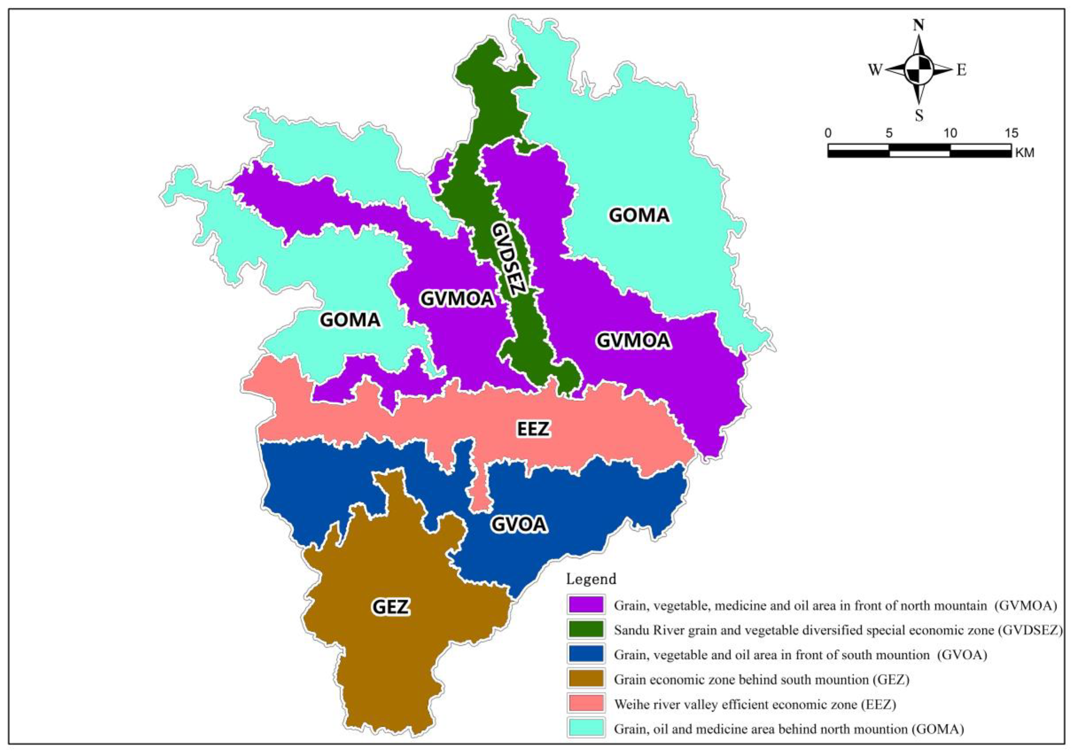
In this study, the clustering results were imported into ArcGIS and combined with the cognition of the rural development status of Gangu County. The total planting scale was named per the form of “orientation + landform + dominant function type” based on the topography, climate, social economy, and production level of Gangu County, and the function and features in each zone were highlighted. Gangu County was categorized into six functional areas as follows: (i) high-efficiency economic zone in the Weihe River Valley (88 villages in four towns); (ii) multi-characteristic economic zone featured by valley and tableland grains and vegetables in the Sandu River (24 villages in three towns); (iii) grain–vegetable–medicine–oil zone in the north Qianshan Mountain (99 villages in seven towns); (iv) grain–vegetable–oil zone in the south Qianshan Mountain (66 villages in five towns); (v) grain–oil–medicine zone in the north Houshan Mountain (104 villages in seven towns); and (vi) grain economic zone in the south Houshan Mountain (27 villages in three towns (Figure 6).
6. Zoning Guidelines for Village Construction Planning
To further optimize the village layout and resource allocation, fortify village infrastructure and public service allocation, and implement the rural revitalization strategy, this study proposed coping strategies for the construction and development of each village area based on the village classification results outlined above and the problem-oriented approach.
6.1. High-Efficiency Economic Zone in the Valley of the Weihe River Valley
The area is 1200–1500 m above sea level, with the development of vegetable-based economic industry advantaged natural geographical conditions. It involves 88 administrative villages in four towns in the river district. The planned distribution is 148,600 mu, accounting for 13.68% of the total planting scale. In addition, grain crop distribution is 167,000 mu, accounting for 11.24% of the area, primarily high-quality and high-yield crops, wheat 0.83 million mu, corn 0.6000 mu, potatoes 0.17 million mu, the other 0.05 million mu. Cash crops are 131,900 mu, accounting for 88.76% of the area, and vegetables are the leading industry in the area, with high-quality fine vegetables and spicy vegetables as the main crop, with the planning layout of 120,600 mu, as well as oil crops 0.85 million mu; Chinese medicinal materials 0.25 million mu, and other miscellaneous crops 0.03 million mu.
Development Orientation:
Rural revitalization should give full play to its regional advantages, primarily the planting of vegetable crops, actively creating agricultural planting demonstration areas, and orderly realizing agricultural and rural modernization.
Direction:
- Expand the area of specialized vegetable fields and increase the total vegetable production. Upgrade and transform the existing vegetable plots, increase the productivity of fresh and feature vegetables, and develop new high-standard vegetable plots per the climate and geographical advantages of the valley area.
- Adhere to the combination of natural endowment and practical production and demarcate regions scientifically. Concentrate investment in advantageous production areas, augment agricultural infrastructure construction, increase vegetable production and management level, and fast-track vegetable industrialization process by demonstrating advantageous production areas.
- Actively introduce, test, demonstrate, and promote new vegetable varieties and new technology. With base farmers and leading enterprises as the carrier, introduce new varieties or advanced cultivation and management technologies, conduct experiments and demonstrations, augment radiation driving, gradually expand new vegetable planting fields, fill the gap in county vegetable production, and realize the variety diversification of vegetable production and supply.
- Establish and upgrade the vegetable seed breeding system, build a professional vegetable seedling base based on the base, provide high-quality seedlings for vegetable production, and actively select and cultivate vegetable varieties with local characteristics. Furthermore, reinforce the production advantages of local specialty vegetables and promote the development of the vegetable industry.
- Increase the vegetable planting level with the help of leading enterprises, improve high-quality production, and enhance the core competitiveness by gathering the scattered smallholders.
6.2. Multi-Characteristic Economic Zone Featured by Valley and Tableland Grains and Vegetables in the Sandu River
The area is 1300–1600 m above sea level, with certain facilities and irrigation conditions, suitable for the production of high-quality drought-resistant crops. It involves three townships and 24 administrative villages in Chuantai district, with the planned planting area of 128.6 million mu, accounting for 11.84% of the total planting scale. Grain crops are mainly high-quality and drought-tolerant varieties, with 69.7 million mu planted, accounting for 54.20% of the area, including 32,000 mu of wheat, 28,200 mu of corn, 0.85 million mu of potatoes, and 0.1 million mu of other crops. In addition, cash crop is planted with 58,900 mu, accounting for 45.80% of the area. Rape seed is mainly drought-resistant and high-yield variety, with a distribution of 20,600 mu; drought-tolerant and temperature-loving vegetables, 33,800 mu; Chinese medicinal materials, 0.43 million mu; and other miscellaneous types, mainly drought-tolerant, 0.02 million mu.
Development Orientation:
Rural revitalization should adhere to the regional advantages, develop wheat, corn, potatoes, vegetables, and other characteristics of the industry, build ecological agricultural grain and vegetable multi-characteristics of economic zones, to promote rural revitalization.
Direction:
- Alter the development mode of ecological agriculture and lay the foundation for developing a food and vegetable diversified characteristic economic zone through multiple channels. Operate per the market, take the form of mutual civil assistance as the primary way of financing, and focus on creating industrial linkage pattern, multichannel, multifaceted, multi-angle construction of the multi-characteristic economic zone.
- Establish a monitoring and evaluation system. To monitor the technology, regional environment, benefits, and other aspects of agricultural development, ensure that the applied technology of agricultural development fulfills the requirements of regional ecological construction, ascertain the role of regional agriculture on the environment, and measure the impact of agricultural development on the living standards of local farmers.
- A reasonable selection of grain and cash crops based on the regional characteristics can enhance the agricultural economic efficiency and limit the development of inefficient agriculture to improve the agricultural production structure.
- Expand the development space of the economic zone. Expand the development space of the economic zone with diversified characteristics of food and vegetables, coordinate the joint participation and operation of various departments, such as environment, resources, ecology, society, economy, biology, engineering, and business, establish an interdisciplinary, cross-departmental, and cross-regional market supply chain system, and promote the effective connection of the industrial chain. It is beneficial to address the contradiction between long-term agricultural economic benefits and short-term agricultural economic benefits and prepare for the construction and development of a regional agricultural base in a broader field.
6.3. Grain–Vegetable–Medicine–Oil Zone in the North Qianshan Mountain
The area is 1400–1900 m above sea level, rich in light and heat resources, high temperature and drought, suitable for drought-resistant crops’ growth and development. This zone covers 99 administrative villages in seven townships, with a planned distribution of 328,100 mu, accounting for 30.20% of the total planting scale. In addition, the zone comprises 242,100 mu of grain crops, accounting for 73.79% of the area, including 132,700 mu of wheat, 66,400 mu of corn, 37,200 mu of potatoes, and the other 0.58 million mu. Cash crops include 86,000 mu, 26.21% of the area, 33,900 mu of oil, 24,000 mu of warm and drought-resistant vegetables, 27,500 mu of Chinese medicinal materials, and 0.06 million mu of other miscellaneous crops.
Development Orientation:
Rural revitalization should grasp the production structure of grain and cash crops and focus on the development of grain, vegetable, medicine, and oil industries.
Direction:
- Increased efforts should be made to adjust the industrial structure, attain self-sufficiency and stable supply of grains, suitably expand the proportion of cash crop in planting, and actively develop township enterprises. Meanwhile, attention should be paid to accelerate the control of soil erosion and desertification, as well as the protection and enhancement of the agricultural ecological environment.
- Fortify the construction of basic farmland, continually improve the conditions for agricultural production, and strive to increase the yield per unit area. Take good care of the irrigated land and actively build large-scale water-saving agricultural projects in areas where conditions permit high yield, high quality, and high efficiency of agriculture. Deliberate attempts are needed to run dry farming projects, strive to change extensive and low-yield planting to intensive farming and management, increase the utilization efficiency of natural precipitation, and increase the yield per unit area and the total yield.
- While focusing on grain production, actively develop cash crops, promote the proportion of oil, vegetable, and traditional Chinese medicine, optimize the rural industrial structure. In addition, focus on the rational use of natural resources and improvement of ecological environment and develop water protection shelterbelts per site conditions of the dry and wet transition zone.
- Adjust measures to local conditions. Integrate biological and engineering measures, and integrate treatment measures of plateau, slope, and ditch treatment measures. Take small watershed as a unit for comprehensive governance, centralized governance, and continuous governance. Focus on the consolidation and improvement of governance to prevent new and repeated damage. Furthermore, fortify and protect natural forests and grassland from attaining a virtuous cycle of agricultural ecosystems step by step.
6.4. Grain–Vegetable–Oil Zone in the South Qianshan Mountain
The area, with an elevation of 1400–1800 m above sea level, has a mild and moist climate, abundant light and heat, and is suitable for the cultivation of grain and crops. This zone covers 66 villages and towns at the front edge of Nanshan, with a planned distribution of 180,200 mu, accounting for 16.59% of the total scale of cultivation. In addition, it includes 121,700 mu of grain crops, accounting for 67.54% of the area, 33,600 mu of wheat, 52,600 mu of corn, 32,900 mu of potatoes, and 26,000 mu of other crops were distributed mainly in the eastern part of the area. Cash crops planted were 58,500 mu, accounting for 32.46% of the area, 25,400 mu of high-quality oil, 28,000 mu of vegetables, 0.48 million mu of Chinese medicinal materials, and 0.03 million mu of other economic and miscellaneous crops.
Development Orientation:
According to the regional planting characteristics, with grain, vegetable, oil as the development characteristics, rural revitalization should be promoted.
Direction:
Unified planning, rational layout, and comprehensive governance under the guidance of the rural revitalization strategy should be undertaken to fortify farmland infrastructure construction centered on water conservancy, continually improve primary conditions for agricultural production, and enhance the ability to withstand natural disasters. There should be an increase in material input, upgrading of technology and equipment, and increased agricultural production capacity. In addition, establishment of an elite-breeding system, implement seed production, purchase, and marketing integrated management to constantly improve crop, forest livestock, and poultry production capacity. Strengthening the construction of institutions and personnel specializing in agricultural scientific research, teaching, and technology to promote the sustainable development of agriculture and the rural economy, should occur. Furthermore, there should be enhancement of the development of transportation and communication, enrichment of rural culture, and promotion of the development of the commodity economy.
6.5. Grain–Oil–Medicine Zone in the North Houshan Mountain
The area is 1600–2000 m above sea level, the climate is cool and moist, with favorable climate for grain, oil, and medicine growth. The zone includes seven townships and 104 villages. The planned distribution is 266,500 mu, accounting for 24.52% of the total scale. Grain crops include 2,051,000 mu, accounting for 76.96% of the area, planted to warm and cool, cold-resistant, disease-resistant, early and medium-maturity crop varieties mainly, layout wheat 993,000 mu, corn 638,000 mu, potatoes 376,000 mu, and other 0.44000 mu. Cash crops are 61,400 mu, 23.04% of the area, 29,000 mu of cold-resistant oil crops, 11,900 mu of cold-resistant vegetables, 20,000 mu of Dangshen-based Chinese medicinal materials, and 0.05 million mu of another miscellaneous category.
Development Orientation:
Per the region’s high terrain and mild temperature, the development of grain-based crops, supplemented by cash crop grain, oil, and pharmaceutical agricultural economic zones will promote rural revitalization.
Direction:
In this zone, the planting area of grain plants is too large, and the planting area of cash crops is too small; thus, the internal planting structure should be adjusted per local conditions. On the premise of guaranteeing self-sufficiency of grain production, the planting area of wheat and corn should be decreased, while that of oil and vegetable should be increased. The planting area of medicinal materials can boost extra agricultural outcomes and increase farmers’ income. Besides, local conditions, such as high altitude, low temperature, and small numbers of pests and diseases, should be considered to develop featured agriculture appropriately, thereby raising the income of farmers and herdsmen. Finally, the planting mode should be changed, and cash crops, such as edible fungi and pollution-free vegetables, can be developed vigorously.
6.6. Grain Economic Zone in the South Houshan Mountain
The region is 1600–2300 m above sea level, with cold climate, humid, lack of light and heat, vegetation coverage, suitable for planting cold-resistant and shade-resistant crops. It covers 27 administrative villages in three townships, such as Gupo, with a distribution scale of 34,500 mu, accounting for 3.18% of the total planting scale. Grain crops include 212,000 mu, accounting for 61.45% of the area, with short growth period, early maturity, disease-resistant, and cold-resistant crops mainly. Planning wheat involves 0.41 million mu, corn 13 million mu, potatoes 0.36 million mu, and the other 0.5 million mu. In addition, cash crops include 330,000 mu, accounting for 38.55% of the area, 0.36 million mu of oil, 0.67 million mu of vegetables, 0.29 million mu of Chinese medicinal materials, and 0.01 million mu of other miscellaneous categories.
Development Orientation:
As the region is located in the high cold, cash crops are not easy to grow in the cold-resistant grain economic zone.
Direction:
- Reinforce the construction of the agricultural technology service system, train farmers in planting science and technology of alpine crops and augment the planting capacity.
- Fast-track the adjustment of the agricultural and rural industrial structure and encourage development with a focus on the dominant crops such as potato, develop traditional high-standard Chinese medicine, develop winter wheat vigorously, and strengthen the application of a plastic film.
- Consider the advantages of herbage planting in the alpine region, return the cultivated land to grass and forest, attach importance to the development of herbage production, and implement the integrated development of agriculture and animal husbandry.
- Make special efforts to improve the ecological environment in alpine regions and effectively prevent soil erosion by adopting new energy and growing fruit trees to realize the harmonious development of natural agriculture.
7. Discussion and Conclusions
7.1. Discussion
From the county functional evaluation and correction factor evaluation, we constructed the type identification index system of rural revitalization villages and defined the functional orientation and development direction of each type, to optimize and strengthen the construction of the village facilities, and improve the living environment of the people in rural areas [3].
Based on the functional characteristics of each dimension of the village, the whole village of Gangu County is divided into six functional areas: the Weihe River Valley high-efficiency economic area; Sandu River Taiwan grain and vegetable multi-characteristic economic area; North Front Mountain grain, vegetable, medicine, and oil area; South Front Mountain grain, vegetable, and oil area; North Back Mountain grain, oil, and medicine area; and south back mountain grain and economic area.
Together with the development goal orientation of zoning types, this study proposes the control rules and development path of county spatial zoning respectively to realize differentiated management in order to improve the agricultural production efficiency and guide the development of rural industries with distinctive characteristics. Under such a circumstance, the rural construction would be promoted as a whole, the rural governance ability would be developed, and the realistic landing of planning would also be augmented [4].
Compared with the existing research results, this study changes the traditional rural planning model, overseeing the type and development orientation of rural functional zoning, and the rough model of “one size fits all” in the depth of preparation content. This study will also guide the village to retain its traditional settlement spatial structure and rural characteristics, which would help the accurate preparation and management of rural planning in the future [5].
Although this study chose Gangu County, Gansu Province, an underdeveloped area in Western China, as the research object, the research methodology is generally applicable, and also has a certain reference significance for the revitalization of rural areas in the world’s underdeveloped areas.
7.2. Conclusions
At present, China is promoting territorial space planning. The premise to ensure the scientificity and operability of the spatial zoning system for rural revitalization is to reasonably connect various plans, improve the institutional guarantee for rural revitalization, and establish and improve urban-rural integrated development mechanism system and policy system.
Taking Gangu County as an example, this study constructed the framework of County Rural Revitalization zoning system and divided Gangu County into “six functional zoning.” The proposed spatial zoning system is applicable in Gangu County, and the zoning results align with the reality of Gangu County, which has practical guiding value for the preparation of rural revitalization planning. Planning and layout are crucial for rural development; however, it should be emphasized that this case area is a typical county in Northwest China, so it is necessary to continue empirical research on other areas. When applied to the actual zoning, building a suitable index system per local conditions for different counties is the key to reasonably divide village types and village types. In addition, the zoning results should properly refer to the existing relevant planning drawings and other zoning results to avoid corresponding confusion. Meanwhile, through the case study of this region, it provides a solution to the rural governance model in China’s underdeveloped areas to promote the theoretical and practical system of rural spatial planning discipline to mature and enrich.
Author Contributions
Conceptualization, Y.W. and X.C.; Formal analysis, Y.W.; Methodology, Y.W.; Writing—original draft, Y.W. and X.C.; Writing—review & editing, X.C. All authors have read and agreed to the published version of the manuscript.
Funding
This research was funded by [Key Bidding Project of Social Science Planning of Gansu Province in 2020] grant number [20ZD012]; [National Natural Science Foundation of China] grant number [42171184]. And The APC was funded by [Key Bidding Project of Social Science Planning of Gansu Province in 2020].
Data Availability Statement
The data presented in this study are available on request from the corresponding author.
Conflicts of Interest
The authors declare no conflict of interest.
References
- Shalaby, Y.; Alzahrani, K.H.; Baig, M.B.; Straquadine, G.S.; Aldosari, F. Threats and challenges to sustainable agriculture and rural development in Egypt: Implications for agricultural extension. J. Anim. Plant Sci. 2011, 21, 581–588. [Google Scholar]
- Deisenhofer, P. Die Dorferneuerung nach dem Flurbereinigungsgesetz and die staetebauliche Dorfsenierung; Domus Verlag: Bonn, Germany, 1996. [Google Scholar]
- Milbert, A. Wandel der Lebensbedingungen in landlichen Raum Deutschlands. Geogr. Rundsch. 2004, 56, 2633. [Google Scholar]
- Margel, H. Dorfernererung in Deutschland; DG Bank: Stuttgart, Germany, 1992. [Google Scholar]
- Henkel, G. Changing concepts for and features of village development in Germany from 1950 to the present. In The Countryside in the 21st Century; Schmied, D., Wilson, O., Eds.; Naturwissenschaftliche Gesellschaft: Bayreuth, Germany, 2005. [Google Scholar]
- Vesterby, M. Rural Residential Land Use:Residential Land Use Is Growing Faster in Rural Than in Urban Areas. Landsc. Urban Plan. 2014, 129, 55–64. [Google Scholar]
- Huang, Z. On the strategy of rural revitalization in China. Chin. Rural. Econ. 2018, 4, 2–12. [Google Scholar]
- Ye, X. The general principles of the China’s rural vitalization strategy in the new era. Reform 2018, 1, 65–73. [Google Scholar]
- Liu, C.; Zhang, Z. From urban-rural integration to urban-rural integration: Reflections on the new urban-rural relationship. Geogr. Sci. 2018, 38, 1624–1633. [Google Scholar]
- Zhang, J. Rural value orientation and rural revitalization. China’s Rural. Econ. 2018, 1, 2–10. [Google Scholar]
- Zhang, Y.; Long, H.; Ma, L.; Tu, S.; Chen, K. Research progress of urban-rural relations and its implications for rural revitalization. Geogr. Res. 2019, 38, 578–594. [Google Scholar]
- Ye, J.; Zhang, M.; Dou, S. Rural vitalization: Who are talking about it, about what? J. China Agric. Univ. (Soc. Sci. Ed.) 2018, 3, 5–14. [Google Scholar]
- Zhang, H.; Hao, L.; Yan, K. Strategic thinking on rural revitalization strategy: Theoretical origin, main innovation and realization path. Chin. Rural. Econ. 2018, 11, 2–16. [Google Scholar]
- He, R. Urban-rural integration and rural revitalization: Theory, mechanism and implementation. Geogr. Res. 2018, 37, 2127–2140. [Google Scholar]
- Liu, Y. Research on the urban-rural integration and rural revitalization in the new era in China. Acta Geogr. Sin. 2018, 73, 637–650. [Google Scholar]
- Chen, D.; Zhang, Y. The logic, key and path of urban-rural integration under the Rural Revitalization Strategy. Macroecon. Manag. 2019, 1, 57–64. [Google Scholar]
- Qiao, L.; Liu, Y. China’s rural revitalization strategy and rural homestead system reform in the new period. Geogr. Res. 2019, 38, 655–666. [Google Scholar]
- Hu, S.; Wu, S.; Liu, Y. A preliminary study rural revitalization planning and its key technologies. Geogr. Res. 2019, 38, 550–562. [Google Scholar]
- Qiao, L. Study on village type identification and Revitalization Strategy: A case study of Changzi County, Shanxi Province. Prog. Geogr. 2019, 38, 1340–1348. [Google Scholar] [CrossRef]
- Alsafadi, K.; Bi, S.; Bashir, B.; Hagras, A.; Alatrach, B.; Harsanyi, E.; Alsalman, A.; Mohammed, S. Land suitability evaluation for citrus cultivation (Citrus ssp.) in the southwestern Egyptian delta: A GIS technique-based geospatial MCE-AHP framework. Arab. J. Geosci. 2022, 15, 1–17. [Google Scholar] [CrossRef]
- Wei, W.; Liu, C.; Ma, L.; Zhang, X.; Xie, B. Ecological Land Suitability for Arid Region at River Basin Scale: Framework and Application Based on Minmum Cumulative Resistance (MCR) Model. Chin. Geogr. Sci. 2022, 32, 312–323. [Google Scholar] [CrossRef]
- Li, X. Research on the Management and Transformation of Urban Villages in Urban and Rural Integration; Springer: Singapore, 2022. [Google Scholar]
- Shen, J.; Wang, J.; Ma, Y. Exploration and practice of guiding the development of county rural space in Northwest Mountainous Areas–Taking the layout planning of county villages in Mian County as an example. Archit. Cult. 2016, 37–40. [Google Scholar]
- Wu, X. Analysis on County Rural Construction Planning of Qiongzhong Li and Miao Autonomous County under the background of urban-rural overall planning. Planner 2018, 39, 139–146. [Google Scholar]
- Zhang, J.; Wang, N. Preliminary Study on village layout planning in County (city) area. Planners 2005, 23–25. [Google Scholar]
- Zhang, Y.; Xing, T. Exploration and practice of spatial layout optimization of county villages—Taking the spatial layout planning of villages in Wu’an city, Hebei Province as an example. Urban Plan. 2009, 33, 88–92. [Google Scholar]
- Fan, S.; Wang, L.; Qin, S.; Liu, S.; Hao, S. Preliminary study on the distribution planning of county villages in mountainous areas of Southern Shaanxi. Urban Plan. 2009, 33, 83–87. [Google Scholar]
- Cao, L. Thoughts on the compilation of County Rural Construction Planning—Taking Shexian County Rural Construction Planning as an example. J. Urban Plan. 2017, 81–88. [Google Scholar]
- Zhao, Y.; Duan, W. Study on the compilation method of County Rural Construction Master Plan—A case study of Anxin County Rural Construction Master Plan in Hebei Province. Planner 2016, 32, 112–118. [Google Scholar]
- Song, D.; Lu, D. Discussion on village distribution planning method. J. Urban Plan. 2010, 65–71. [Google Scholar]
- Liu, X.; Zhou, Y.; Zhou, X. Research on the Whole Village Layout Planning from the Perspective of New Urbanization—Taking the Whole Village Layout Planning of Shenyang as an Example; China Construction Industry Press: Beijing, China, 2015. [Google Scholar]
- Jiang, Z.; Jin, P. Study on the realization path of abandoned mine land value from the perspective of “resource-asset-capital”. China’s Popul. Resour. Environ. 2013, 157–163. [Google Scholar]
- Lin, Z.; Zhang, R.; Tang, P.; Li, S. Exploration on the preparation of town village layout planning from the perspective of the whole region. Planner 2014, 94–99. [Google Scholar]
- Wang, Y.; Duan, W. Study on County Rural Construction Planning Based on Ecological Carrying Capacity—Taking Baiyangdian area of Anxin County, Hebei Province as an example. Small Town Constr. 2017, 18–23. [Google Scholar]
- Geng, H.; Dong, M.; Gao, P. Discussion on Urban Village Layout Planning Path under New Urbanization—Taking Yicheng City as an Example; China Construction Industry Press: Beijing, China, 2018. [Google Scholar]
- Guo, W.; Lu, F. Exploration and Practice of Rural Planning Under the Overall Planning Thinking—Taking the “One Map” of Rural Construction Planning in Wuhan as an Example; China Construction Industry Press: Beijing, China, 2018. [Google Scholar]
- National Leading Group Office for Planning and Preparation of Main Functional Areas. National Main Functional Area Planning (2008–2020) [DB/0L]. Available online: http://www.gov.cn/zwgk/2011-06/08/content_1879180.htm (accessed on 8 June 2011).
- Gansu Provincial Development and Reform Commission, School of Resources and Environment. Lanzhou University Research Report on the Division of Main Functions in Gansu Province; Lanzhou University Press: Lanzhou, China, 2009. [Google Scholar]
- Shen, J.; Wang, J.; Ma, Y. Exploration and Practice on the guidance of County Rural Spatial Development in Northwest Mountainous Areas–Taking the layout planning of county villages in Min county as an example. Archit. Cult. 2016, 37–40. [Google Scholar]
- Niu, M.; Shi, S.; Guo, P. Xiaodong Spatial functional zoning and future spatial development pattern of Tianshui City—Based on the framework of main functional zoning. Econ. Geogr. 2015, 35, 68–77. [Google Scholar]
- Guo, X.; Zhang, M. Qiyuan Study on spatial evolution characteristics and driving mechanism of rural settlements in Qin’an County Based on GIS. Econ. Geogr. 2012, 32, 56–62. [Google Scholar]
- Yang, X.; Wu, X.; Fan, Y.; Han, X.; Zhang, S.; Jin, X. Village classification and renovation strategy of Lijin County under the guidance of planning. J. Agric. Mach. 2020, 51, 232–241. [Google Scholar]
- Zheng, X. Research on evaluation index system of Rural Revitalization potential based on classified promotion—Survey data from 6 villages in 3 counties and cities of Fujian Province. Soc. Sci. 2019, 36–47. [Google Scholar]
Figure 1.
The geographical location of Gangu County.

Figure 2.
Comprehensive status quo of Gangu County.

Figure 3.
Production function index of agricultural products.

Figure 4.
Living function index.

Figure 5.
Ecological regulation function index.

Figure 6.
Spatial zoning map for the rural areas in Gangu County.


Table 1.
Comprehensive evaluation index system of rural function.
| Index Layer. | Index Layer | Primary Indicator | Indicator Property | Definition and Calculation Method (Score Standard) | Positive or Negative | Data Source | Weight |
|---|---|---|---|---|---|---|---|
| Fundamental functions | Production function | Cultivated land area | Quantitative | The total area of cultivated land in the village | + | The 3rd National land survey | 0.52 |
| Cultivated land connectivity | Quantitative | Land connectivity index calculation | + | The 3rd National land survey | 0.20 | ||
| Length of the irrigation canal | Quantitative | Length of an irrigation canal in the village | + | The 3rd National land survey | 0.28 | ||
| Living function | Occupying land in the residential zone | Quantitative | The total area of urban and rural construction land in villages | + | The 3rd National land survey | 0.14 | |
| Concentration of the residential zone | Quantitative | Calculation of the most adjacent index | + | The 3rd National land survey | 0.14 | ||
| fragmentation of the residential zone | Quantitative | Calculation of the most adjacent index | - | The 3rd National land survey | 0.14 | ||
| Completeness of public facilities | Quantitative | Complete; Bad | + | Village questionnaire | 0.16 | ||
| Village population | Quantitative | Registered population | + | Statistics or village questionnaire | 0.08 | ||
| Aging severity of resident population | Quantitative | Proportion of population aged >60 years | - | Statistics or village questionnaire | 0.05 | ||
| Completeness public service facilities | Quantitative | Complete; medium; bad | + | Only POI data or village questionnaire | 0.12 | ||
| Completeness of commercial service | Quantitative | Completeness of commercial service facilities | + | Online POI data or village questionnaire | 0.12 | ||
| Radiation capacity of the village | Quantitative | Number of residential zones within the half-hour life circle in the village | + | Only POI and road data | 0.05 | ||
| Potential functions | Ecological function | Ecological value | Quantitative | Vegetation coverage | + | Geospatial data cloud TM images | 0.48 |
| Landscape value | Quantitative | Landscape index | + | The 3rd National land survey | 0.52 | ||
| Cultural function | Identification of the village title | Quantitative | Has the relevant identified village title or not | + | Village questionnaire | 0.46 | |
| Intangible cultural heritage in the village | Quantitative | Intangible heritage at the county level or higher | + | Village questionnaire | 0.34 | ||
| Comprehensive judgement of the village culture | Qualitative | Distinctive cultural features of the village | + | Village questionnaire | 0.20 | ||
| Corrected evaluation | Natural endowment | Proportion of plain land in the village area | Quantitative | Proportion of land with a topographic slope less than 8° in the village area | + | Geospatial data cloud DEM | 0.48 |
| Proportion of the available land in the village area | Quantitative | Ratio of the available land area to the village area | + | The 3rd National land survey | 0.52 | ||
| Geographical conditions | Spatial relationship with the city center | Qualitative | Contain or near, away | + | Village questionnaire or others | — | |
| Spatial relationship with the town | Qualitative | Contain or near, away | + | Village questionnaire or others | 0.52 | ||
| Relationship with large industrial and mining enterprises | Qualitative | Contain or near, away | + | Village questionnaire or others | 0.20 |
Publisher’s Note: MDPI stays neutral with regard to jurisdictional claims in published maps and institutional affiliations. |
© 2022 by the authors. Licensee MDPI, Basel, Switzerland. This article is an open access article distributed under the terms and conditions of the Creative Commons Attribution (CC BY) license (https://creativecommons.org/licenses/by/4.0/).
Share and Cite
MDPI and ACS Style
Wang, Y.; Cao, X. Village Evaluation and Classification Guidance of a County in Southeast Gansu Based on the Rural Revitalization Strategy. Land 2022, 11, 857. https://doi.org/10.3390/land11060857
AMA Style
Wang Y, Cao X. Village Evaluation and Classification Guidance of a County in Southeast Gansu Based on the Rural Revitalization Strategy. Land. 2022; 11(6):857. https://doi.org/10.3390/land11060857
Chicago/Turabian StyleWang, Yongzhen, and Xianzhong Cao. 2022. "Village Evaluation and Classification Guidance of a County in Southeast Gansu Based on the Rural Revitalization Strategy" Land 11, no. 6: 857. https://doi.org/10.3390/land11060857
Note that from the first issue of 2016, this journal uses article numbers instead of page numbers. See further details here.