
The Effects of Agricultural Conservation Practices on the Small Water Cycle: From the Farm- to the Management-Scale


Department of Landscape Water Conservation, Faculty of Civil Engineering, Czech Technical University in Prague, 12000 Prague, Czech Republic
*
Author to whom correspondence should be addressed.
Land 2022, 11(5), 683; https://doi.org/10.3390/land11050683
Submission received: 23 March 2022
/
Revised: 22 April 2022
/
Accepted: 30 April 2022
/
Published: 4 May 2022
(This article belongs to the Special Issue Soil Management for Sustainable Agriculture and Ecosystem Services)
Abstract
:Reinforcing the small water cycle is considered to be a holistic approach to both water resource and landscape management. In an agricultural landscape, this can be accomplished by incorporating agricultural conservation practices; their incorporation can reduce surface runoff, increase infiltration, and increase the water holding capacity of a soil. Some typical agricultural conservation practices include: conservation tillage, contour farming, residue incorporation, and reducing field sizes; these efforts aim to keep both water and soil in the landscape. The incorporation of such practices has been extensively studied over the last 40 years. The Soil and Water Assessment Tool (SWAT) was used to model two basins in the Czech Republic (one at the farm-scale and a second at the management-scale) to determine the effects of agriculture conservation practice adoption at each scale. We found that at the farm-scale, contour farming was the most effective practice at reinforcing the small water cycle, followed by residue incorporation. At the management-scale, we found that the widespread incorporation of agricultural conservation practices significantly reinforced the small water cycle, but the relative scale and spatial distribution of their incorporation were not reflected in the SWAT scenario analysis. Individual farmers should be incentivized to adopt agricultural conservation practices, as these practices can have great effects at the farm-scale. At the management-scale, the spatial distribution of agricultural conservation practice adoption was not significant in this study, implying that managers should incentivize any adoption of such practices and that the small water cycle would be reinforced regardless.
1. Introduction
The small water cycle is the local cycling of water, wherein water should fall as rain in the same geographic area from which it evapo(transpi)rates. The small water cycle also greatly emphasizes a reduction in surface runoff generation in a landscape, and the cycle’s reinforcement is considered to be a holistic approach to managing water resources at the catchment scale [1,2,3]. In an agricultural landscape, certain conservation techniques can greatly improve the water holding capacity of a soil and can, in turn, strongly reinforce the small water cycle, making an agricultural landscape more resilient in the face of climate change.
Agricultural conservation practices have been extensively studied over the last 40 years and have been shown to significantly improve a soil’s infiltration capacity and, consequently, significantly decrease the surface runoff in a landscape [4,5,6,7,8]. The most common agricultural conservation practices in modern literature include reduced/no-tillage, mulch cover/crop residues and cover crops, and reduced application of herbicides. The goal of conservation agriculture is to make soils “self-sustainable” by: maintaining sources of organic matter above and below the soil’s surface, recycling water and nutrients within the system, and ensuring that the infiltration rate of a soil is greater than the predicted rainfall rate [9]. To maximize the benefits of implementing agricultural conservation practices, managers must maintain year-round organic matter cover, minimize soil disturbance, and diversify crop rotations [9,10,11]. The transition from conventional or reduced tillage to no-tillage has been shown to reduce surface runoff by upwards of 20% at the plot-scale [12]. A no-tillage management scheme can increase the infiltration capacity of a soil in two ways: by minimizing soil disruption and by preserving the highest percentage of crop residue cover. No-tillage has also been shown to reduce soil loss, splash erosion, and surface runoff, while increasing direct infiltration [10,13,14]. Maintaining adequate plant cover year-round provides numerous benefits, including improving soil quality, controlling soil erosion, and increasing soil water availability [15]. Plant cover percentage has a significant, negative relationship with final runoff rate, indicating that the greater the plant cover percentage, the lower the expected hourly runoff [16]. While cover crops and crop residues provide year-round soil coverage, they also provide an even-coverage mulching, which has been found to be a more successful mulching strategy in real-life scenarios when compared to artificial mulching with wheat straw, grass clippings, wood chips, etc., [13].
The Intergovernmental Panel on Climate Change (IPCC) predicts that in the face of future climate change, Central Europe will encounter more frequent, intensive storm events, which will magnify landscape management issues in the Czech Republic [17]. The Czech Republic is a highly agricultural country, with nearly 40% of its land area being arable. Agricultural intensification in the Czech Republic began in the 1970s when the landscape was publicly managed. Large fields, subsurface tile drainage systems, and artificially lined and straightened streams were incorporated across the landscape in an effort to increase crop production [18]. Unfortunately, these practices resulted in increased soil loss and reduced deep percolation and groundwater recharge. Since privatization in 1991, some small Czech farms have begun incorporating agricultural conservation practices and IPA (integrated pest management for agriculture) guidelines; however, much of the Czech agricultural landscape is managed by large agricultural conglomerates driven by profit [1,18]. By working to reinforce the small water cycle through the incorporation of agricultural conservation practices, the effects of extreme precipitation events (e.g., huge spikes in surface runoff ratios as well as extreme soil loss events) may be mitigated at the basin-scale, which should incentivize their incorporation to land managers and farmers [17].
The two basins of interest have been monitored for a number of years. The farm-scale basin (Nučice) is equipped to monitor localized basin processes, and previous studies have primarily focused on rainfall–runoff mechanisms and temporarily variable soil properties [19,20,21,22,23]. Sediment transport and erosion have been extensively studied in Vrchlice (the basin utilized for management-scale analysis), especially regarding the sediment trap efficiencies of the nearly 140 reservoirs across the basin [24,25,26,27]. The Soil and Water Assessment Tool (SWAT) has been previously utilized at both basins to assess the effects of land use changes on in-basin water balance [26,27], but since the Czech Republic is likely to remain quite agricultural for the foreseeable future, it is of great interest to assess the impacts of agricultural conservation practice incorporation at each of these scales. While sometimes data intensive, hydrologic models are a relatively easy and non-invasive way to run scenario analyses in a landscape. SWAT is a semi-distributed, semi-physically based, basin-scale hydrologic model. SWAT divides a basin into smaller elements called hydrologic response units (HRUs) that are each comprised of the same soil type, slope class, and land use classification [28,29,30,31]. SWAT was selected for this study because of its flexibility and applicability to agricultural catchments. SWAT makes running scenario analyses simple, and there is significant precedent for its incorporation of agricultural conservation practices [32,33].
The purpose of this study is to investigate the following questions: (i) do the incorporation of agricultural conservation practices impact the small water cycle proportionally at various scales? (ii) Which practice is most effective at reinforcing the small water cycle at the farm-scale? (iii) Does the spatial distribution of agricultural conservation practices affect their impacts on the small water cycle at the management scale? (iv) What do these results imply regarding catchment management and incentivizing farmers to adopt these practices?
2. Materials and Methods
2.1. Study Watersheds
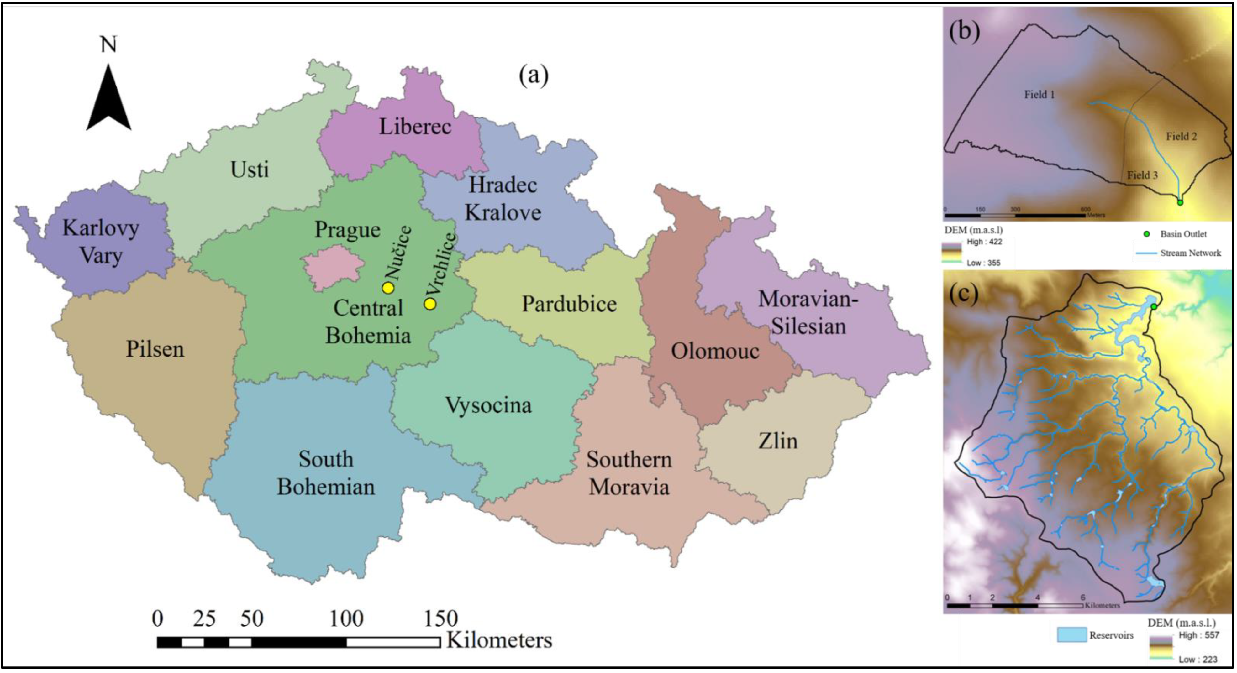
Both study watersheds are located in the Central Bohemia region of the Czech Republic (Figure 1). This region is characterized by a humid continental climate and receives approximately 600 mm of precipitation per year. The rainy season in this region occurs from May through August, and the driest month is usually February. These two basins were selected for this study because they are typical of an intensively agricultural Czech landscape. Nučice is a simply-shaped catchment and represents the farm-scale, containing three large fields, each with very similar crop rotations and management. Vrchlice represents the management-scale. It is much larger (~100 km2), with a more diverse landscape, and its water resources are managed to meet municipal needs. It is valuable to land owners as well as basin managers to determine the effects of agricultural conservation practice adoption at each scale.
The Nučice experimental catchment (“Nučice”) has been monitored since 2011 by the Landscape Water Conservation Department (in the faculty of Civil Engineering) of Czech Technical University in Prague. It is a small watershed (~0.52 km2) consisting of three fields that are managed by two farmers and is appropriate for modeling at the “farm-scale” in the Czech Republic. Its outlet is located at 49°57′49.230′′ N, 14°52′13.242″ E (Figure 1b). The soils in Nučice are classified mainly as Luvisols and Cambisols overlaying siltstone and sandstone. The average slope in Nučice is 3.9% but ranges from 1 to 12%. Nučice is primarily cropland, with a very narrow riparian/brush zone around the stream; the basin is bisected horizontally by a 2-lane road (Table 1).
The Vrchlice Basin (“Vrchlice”) is much larger than Nučice, at ~97 km2 (Figure 1c). Vrchlice also has a more diverse land use, with large areas of forested land as well as many townships (Table 1), but it is still primarily cropland. The Vrchlice Reservoir provides drinking water to the nearby town of Kutná Hora, serving approximately 40,000 inhabitants. Its outlet is located at 49°55′37.211” N, 15°13′37.07” E. The basin is covered in clayey soils classified as Cambisols overlaying a metamorphic bedrock [24]. Vrchlice contains a network of nearly 140 reservoirs, mostly small fish ponds, that serve cultural and hydrologic significance. The discharge at the outlet of the Vrchlice Reservoir has been monitored by the Elbe River Authority since 1979. The Vrchlice Basin is considered to be an appropriate size for modeling at the “management-scale” in the Czech Republic.
2.2. Soil and Water Assessment Tool (SWAT)
SWAT requires the following as its bare minimum regarding data requirements: soils, slopes, land uses, and daily weather data. The input data used for each of the models present in this study are outlined in Table 2.
The daily meteorological data for the Nučice SWAT model was obtained from on-site gauges (Table 2). The climate data for this model was obtained from the Climate Forecast System Reanalysis (CFSR) database; these data are used in case there are any gaps in the observed weather dataset. The digital elevation model (DEM) was obtained from the fifth generation of the digital relief model of the Czech Republic (DMR5G) and was point-cloud processed to obtain a 3 m spatial resolution. The SWAT model for Nučice was developed using the field boundary method [34]. In the field boundary method scheme, each field is defined as its own HRU by aggregating the primary soil type and elevation class for each field. This method was selected in order to incorporate reduced field sizes at the farm-scale and was accomplished through the use of soil dummy variables. The SWAT model for Nučice was run during the growing seasons (~April through October) from 2014 through 2019, using 2013 as a warmup period. Calibration and validation procedures followed those outlined in Noreika et al. 2020 [26].
The Vrchlice SWAT model was developed originally for Noreika et al. 2021 to study the effects of land use and management changes over time in the basin [27]. The model itself has not been edited further. This model was run at the monthly timestep from 2001 through 2019 with a 5-year warmup period (1996–2000). The monthly timestep was chosen to minimize daily effects due to reservoir processes that are not publicly available and therefore unable to be represented in SWAT. The model was calibrated (2001–2012) and validated (2013–2016) at the monthly timestep with discharge data from the basin’s outlet. The basin boundaries and stream network were largely DEM-based, but ground-truthed to existing data. Vrchlice was divided into 63 sub-basins, containing 1058 HRUs that were defined by their unique combinations of land use, slope class, and soil type. For further detail, parameterization, and intricacies of the model setup, please refer to Noreika et al. 2021 [27].
2.3. Scenario Analysis
2.3.1. Literature Review
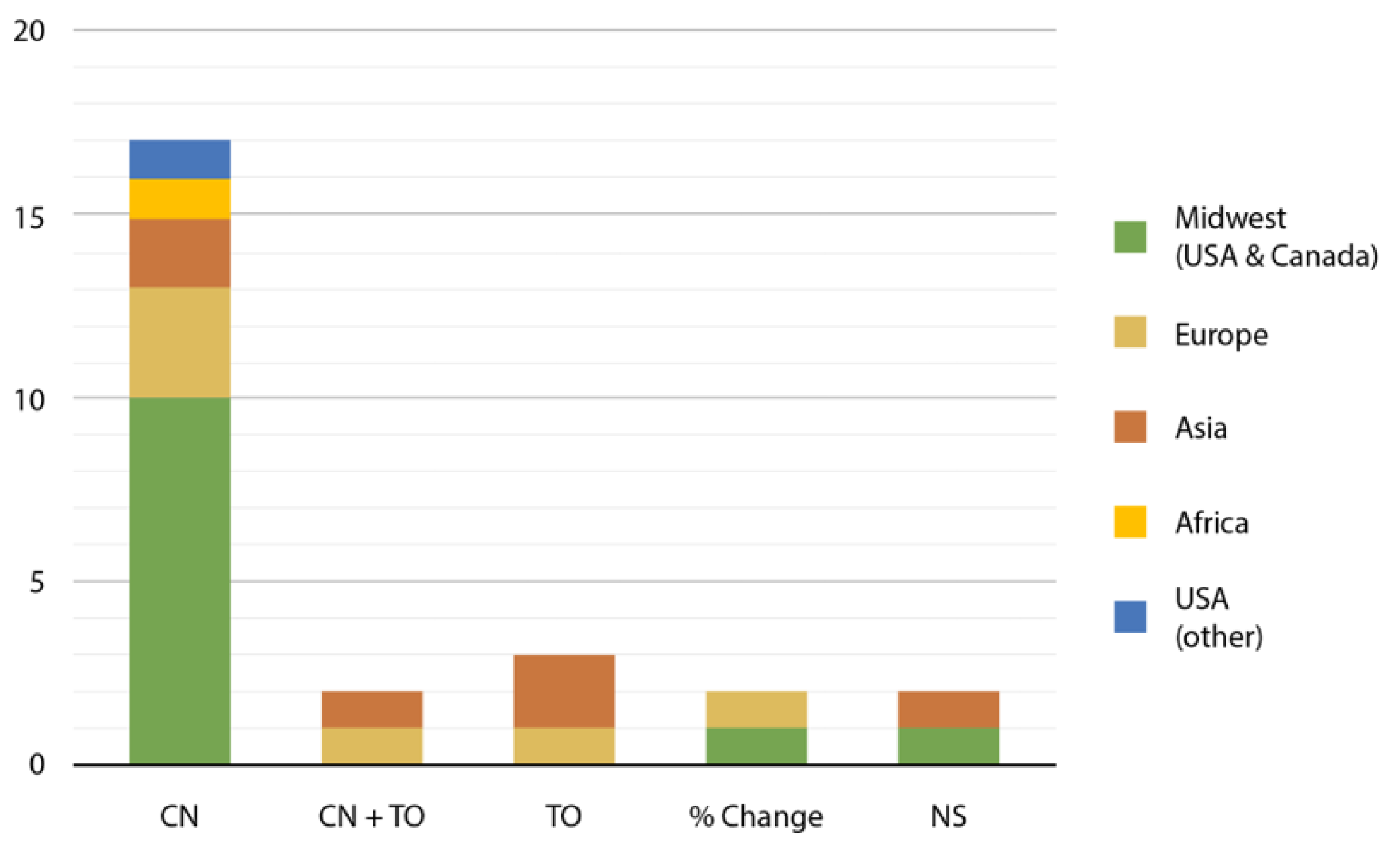
Contour farming results in a reduction of surface runoff by impounding water in small depressions, as well as a reduction of sheet and rill erosion by reducing the erosive power of surface runoff and preventing or minimizing the development of rills. This practice is represented by adjusting the Soil Conservation Service (SCS) curve number in SWAT. Residues are meant to slow down surface and peak runoff by increasing surface roughness. They also increase infiltration and reduce surface runoff by decreasing surface sealing and slowing down overland flow. Finally, residues reduce sheet and rill erosion by reducing surface flow volume. In SWAT, there is significant literature precedent to incorporate these practices; conservation tillage and residue management are typically represented by adjusting the curve number and Manning’s roughness coefficient for overland flow, respectively. In order to incorporate these practices appropriately, a literature review was conducted using the following keywords: SWAT, best management practice, and conservation agriculture [35,36,37,38,39,40,41,42,43,44,45,46,47,48,49,50,51,52,53,54,55,56,57,58,59,60,61,62,63,64,65,66,67]. A total of 33 articles were downloaded and narrowed down to 25 based on relevance. The 25 remaining papers addressed the incorporation of conservation tillage operations, contour farming, and residue management into SWAT (Figure 2). Of the 25, 12 took place in the Midwest (of US and Canada), 1 in Texas, 6 in Europe, 1 in Africa, and 6 in Asia. Overwhelmingly, 17 of the 25 papers referenced Arabi et al. 2008 and Neitsch et al. 2011 publications [32,33], meaning that conservation practices were incorporated via the curve number (CN) method. Three publications introduced tillage operation changes and no CN edits (TO). Two introduced tillage operation changes along with the CN edits (CN + TO). Two modified the CN by a percent change, and two did not specify (NS) how the practices were incorporated into SWAT. We then conducted a scenario analysis at the Nučice basin to determine whether it is necessary to incorporate both CN shifts and tillage operation changes. We found no significant differences between water balance variable outputs (discharge at the basin’s outlet, subsurface lateral flow, surface runoff, evapotranspiration, and soil water content, p > 0.05) when only the CN method was utilized versus shifting both the CN and the tillage practices. We concluded that the CN method is appropriate to incorporate agricultural conservation practices and is also more efficient in the modeling process.
2.3.2. Scenarios Outlined
Five scenarios were run at the farm-scale for this study (Table 3). These scenarios incorporate contour farming, small residues (0.5–1 t/ha), large residues (1–9 t/ha), conservative tillage, and field size reductions at Nučice. To incorporate field size reductions, instead of three fields averaging 17 ha each, Nučice was divided into 52 fields averaging 1 ha each through the use of dummy soil variables. The other scenarios were incorporated as presented in Table 4.
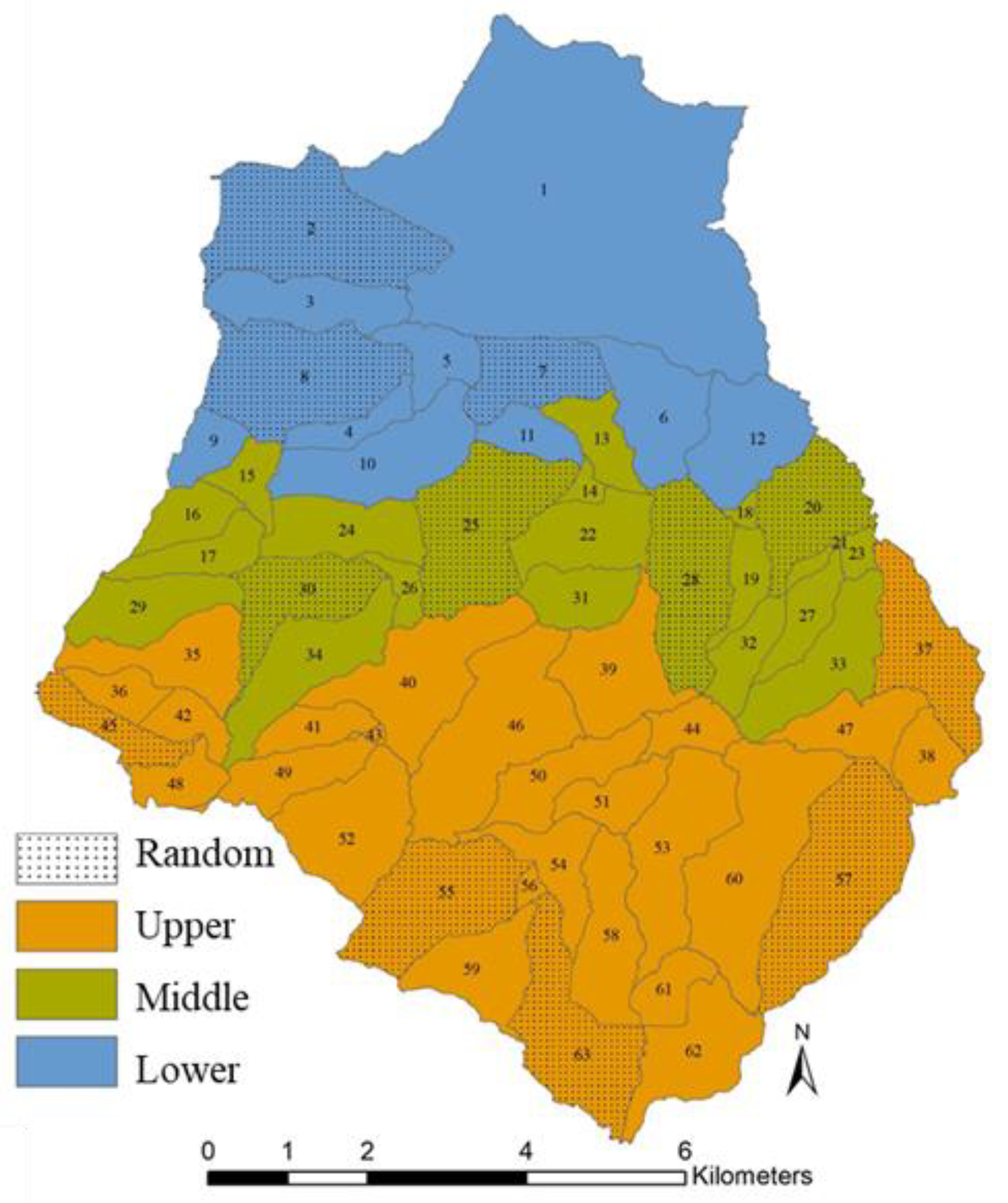
In Vrchlice, only the “General Measures” agricultural conservation scenario was adopted (Table 4) at various scales across the basin (Table 3, Figure 3). The “General Measures” outlined in Table 4 are considered to be “best case scenarios” to represent conditions if the practices were incorporated properly and if the landscape responds as expected, but it is likely that any real-world result would fall somewhere between the calibrated model without any conservation practices and the “General Measures” scenarios. Vrchlice was divided into three regions based on location in the basin and percent area cropland (Figure 3). Each area (Upper, Middle, Lower, Random) comprises approximately 1/3 of the cropland cover in the Vrchlice Basin. Additionally, the Upper Extended and Lower Extended scenarios encompass the Upper + Middle and Lower + Middle areas, respectively, to encompass approximately 2/3 of the cropland cover in the Vrchlice Basin. A requirement for the Random scenario is that no selected sub-basins should be adjacent. The Random scenario controls for the effects of connectivity of agricultural conservation practices to determine if individual farm adoption is “enough” or if regional adoption is necessary to more greatly reinforce the small water cycle. These scenarios were outlined so that the individual impacts of agricultural conservation practice continuity and spatial adoption within the basin could be evaluated.
3. Results
According to the global sensitivity analysis that was conducted, three parameters significantly influenced the modeled discharge flowing out of the Nučice experimental basin (Table 5). RCHRG_DP is the deep aquifer percolation fraction; this value should fall between 0 and 1 as it is the fraction of percolation past the root zone which recharges the deep aquifer. Since this value is very close to 0, this indicates that a very small fraction of water entering the Nučice Basin recharges the deep aquifer. Saturated hydraulic conductivity (SOL_K) and the available water capacity of the soil (SOL_AWC) govern how water is infiltrated and retained in a soil, respectively, were also significantly sensitive parameters.
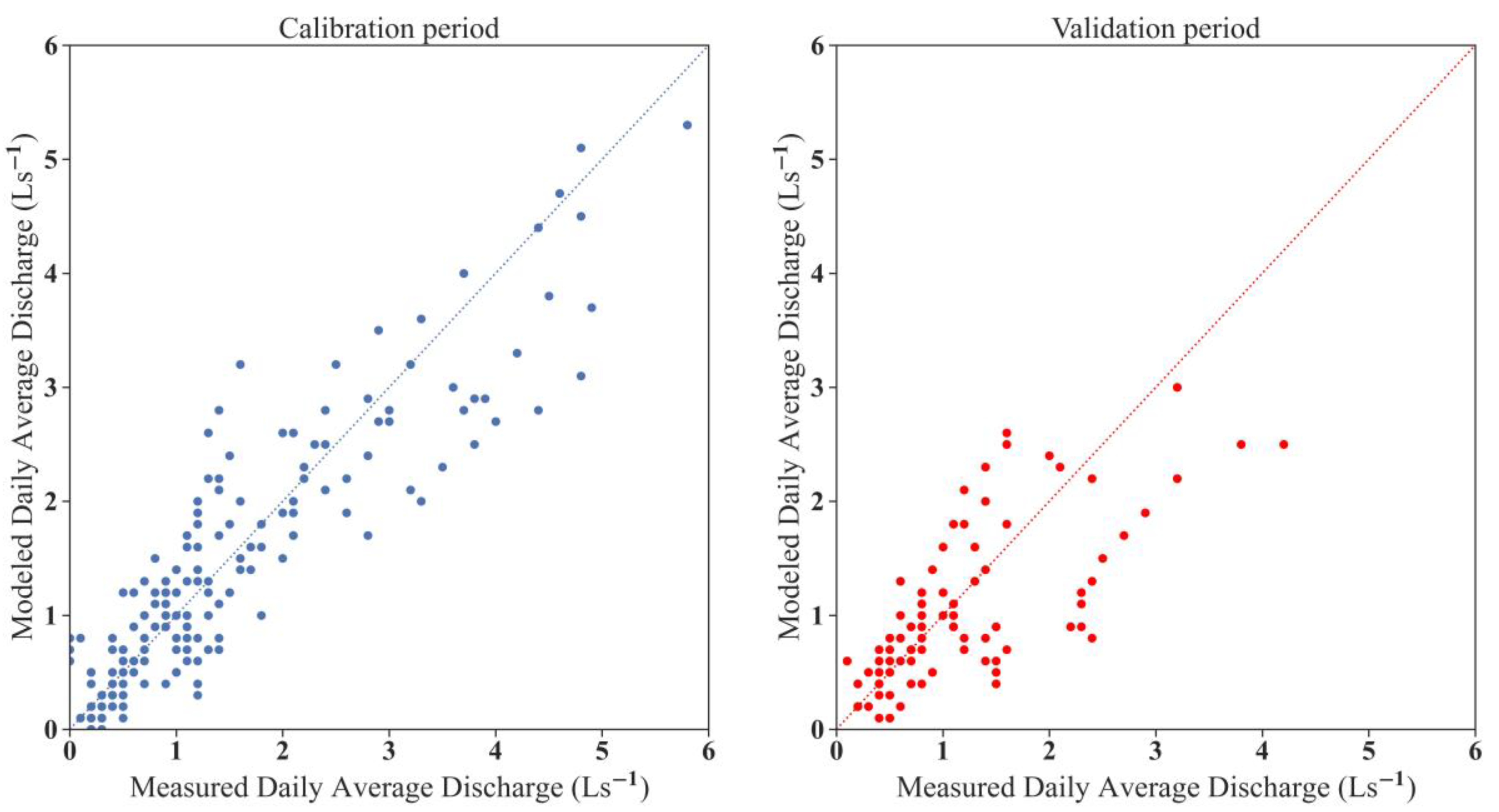
Calibration (2016–2018) and validation (2019) for the Nučice basin were conducted with SWAT-Cup 2019, which is a semiautomatic calibration methodology [28]. Table 6 presents the selected model performance indicators during the calibration and validation periods for the Nučice SWAT model. Figure 4 presents a scatterplot, correlating the modeled discharge values with the observed discharge values at Nučice during the calibration and validation periods.
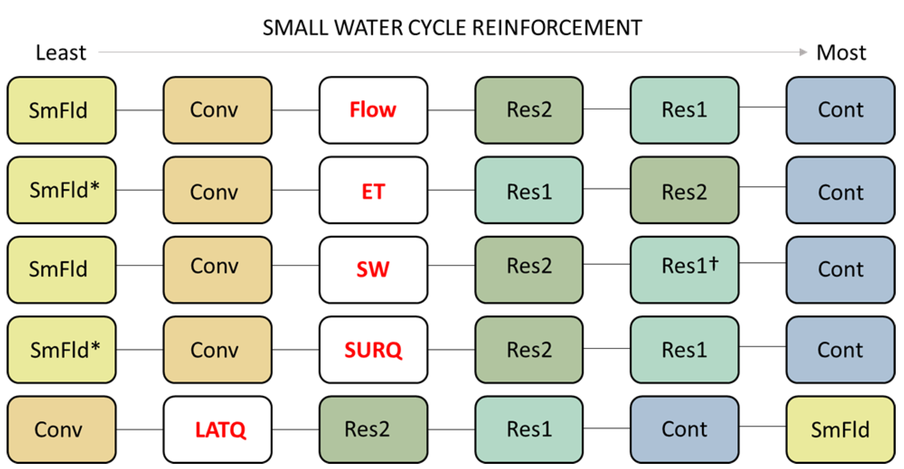
There were significant shifts across water balance parameters with the incorporation of agricultural conservation practices at the Nučice scale (Figure 5). The incorporation of residues and contour farming reinforced all of the small water balance parameters when compared to the calibrated scenario, which included generalized conservation tillage. Resorting to conventional tillage from conservation tillage was consistently contradictory to the goal of reinforcing the small water cycle. Field size reductions resulted in the highest amount of streamflow contribution from subsurface lateral flow, but the model indicated that otherwise the adoption of smaller fields does not reinforce the small water cycle.
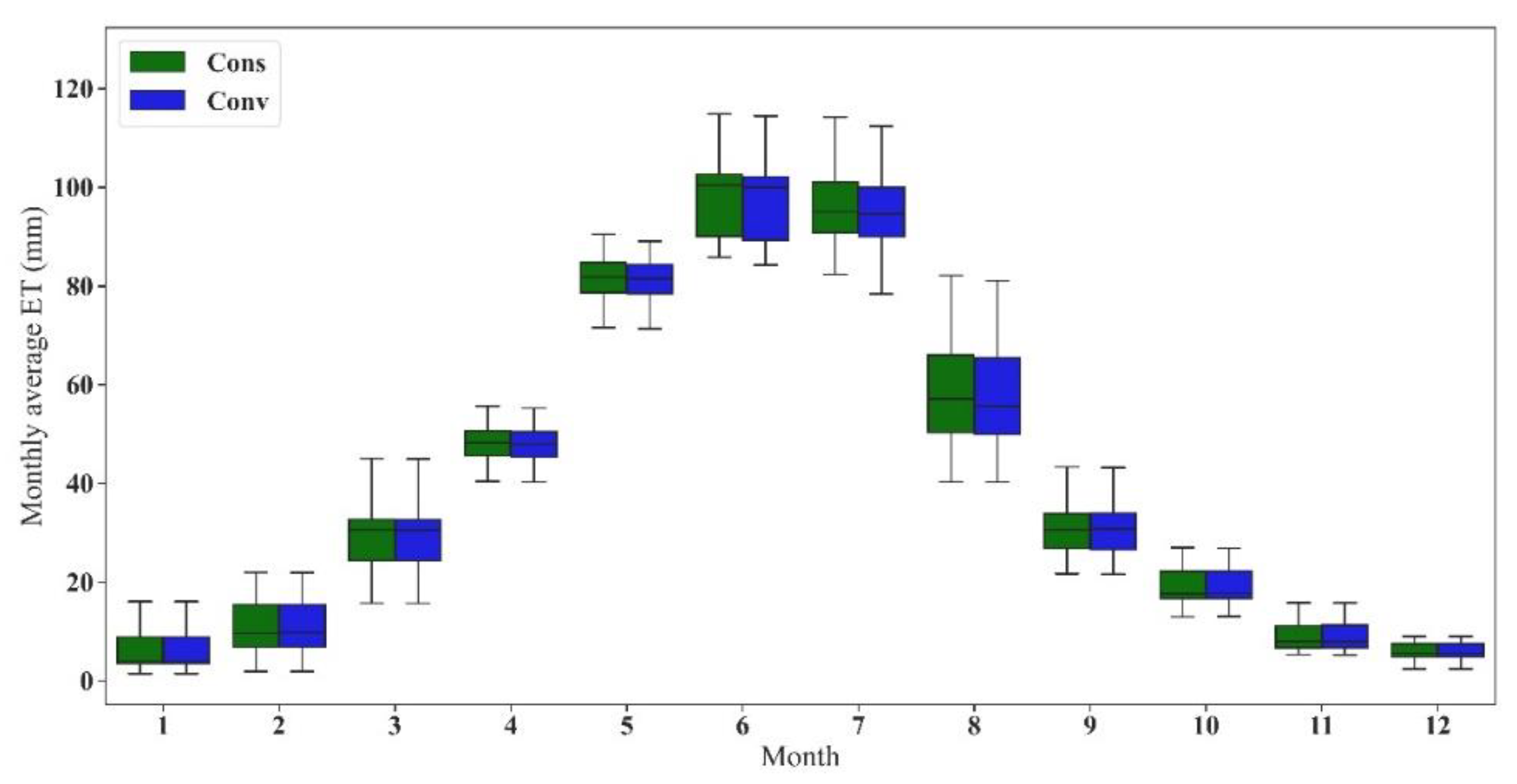
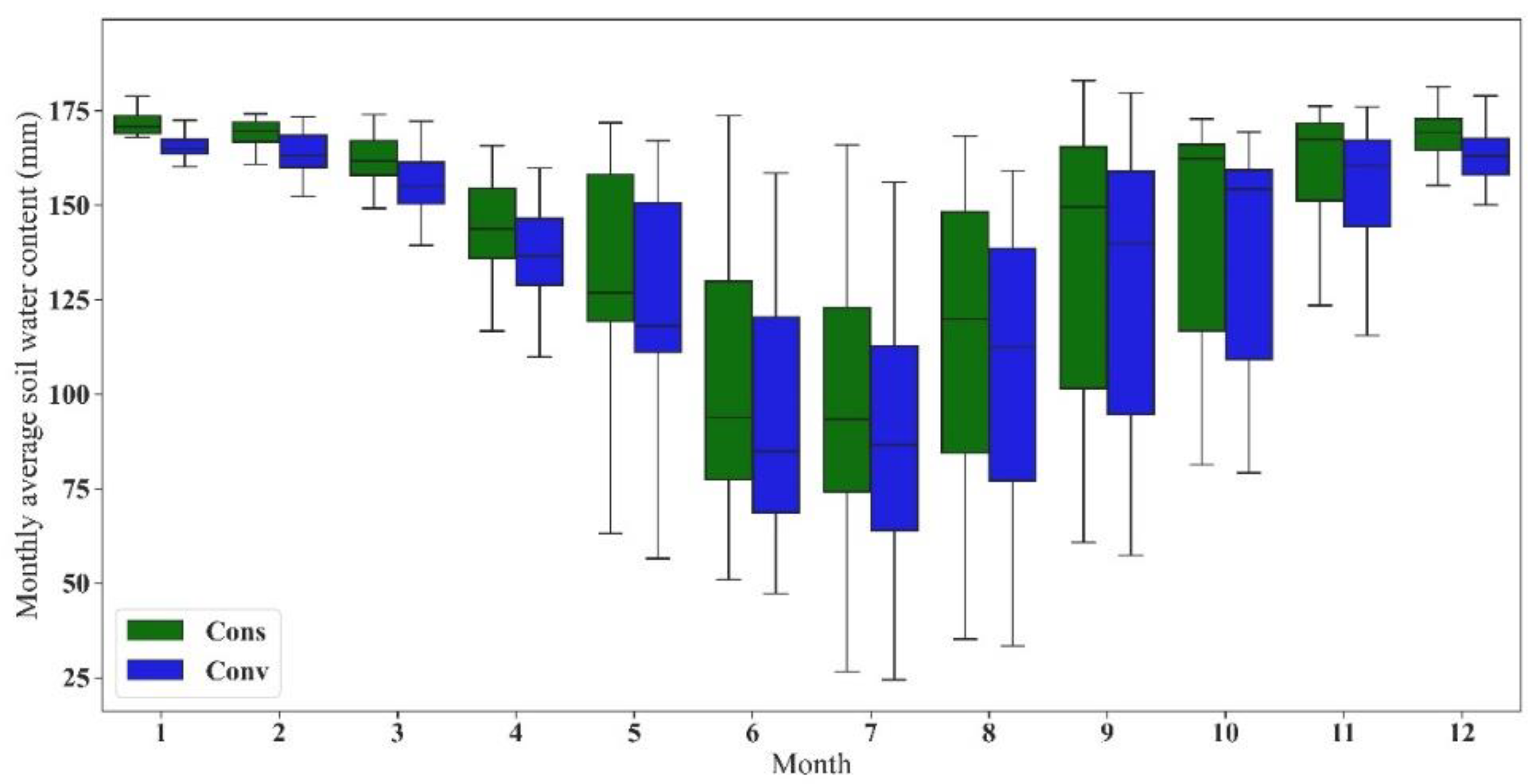
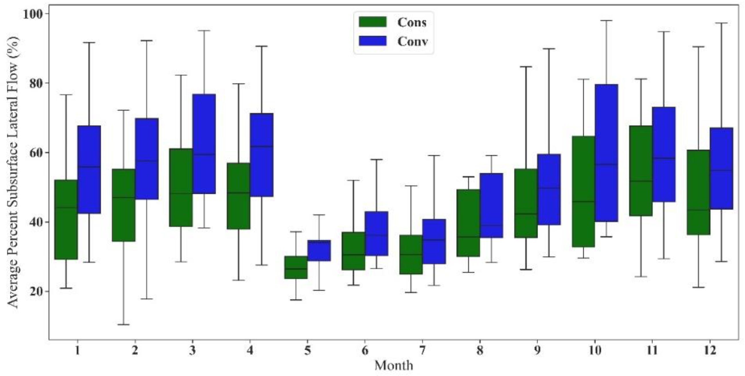
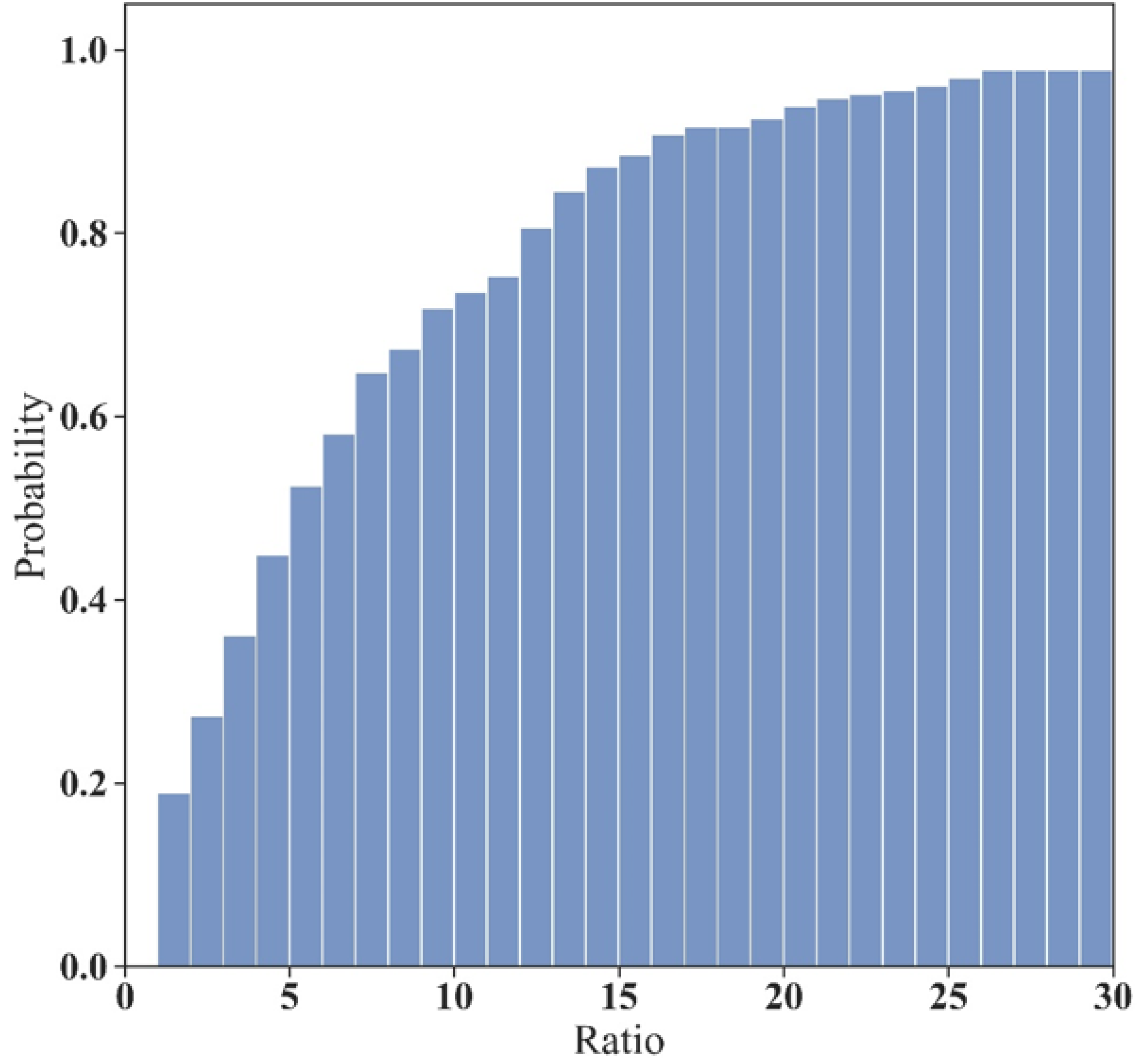
All small water cycle parameters, except for discharge at Vrchlice’s outlet, were significantly affected by the incorporation of agricultural conservation practices across the basin. Interestingly enough, neither the scale of adoption nor the spatial distribution of agricultural conservation practices significantly affected any small water cycle parameters at this scale; further figures presented compare only Vrchlice’s conventional tillage (calibrated model) and the full adoption scenario. Both the available water content and evapotranspiration in the conventional tillage scenario are consistently lower than the full conservation adoption across the entire year (Figure 6 and Figure 7). Both the surface runoff ratios and subsurface lateral flow were significantly higher throughout the year in the conventional tillage scenario when compared to the General Measures full adoption scenario (Figure 8 and Figure 9). Generally surface runoff in the conventional tillage scenario is greater than 2× that of the conservation scenario (Figure 9).
4. Discussion
4.1. Hydrological Modeling with SWAT
There are several possible sources of error in any hydrologic model; the first is input parameter uncertainty, which is the largest possible source of error and also influences uncertainties associated with output data. Model parameterization and model structural uncertainties are additional possible sources of error [62,68]. Furthermore, since SWAT is neither fully physically based nor fully distributed, some processes may not be properly represented, such as temporal changes in topsoil hydraulic properties, preferential flow, or the influences of the spatial distribution of fine-scale land management [28,69,70]. While there are some drawbacks to the SWAT model (as stated above), it is a very useful tool for hydrologic modeling, especially regarding scenario analysis. Currently, Nučice is equipped to model generalized processes rather than more spatially distributed processes (piezometer clusters and a cosmic-ray neutron sensor are currently being installed). The soil data at this scale is fairly coarse and is nearing the lower spatial range of SWAT’s modeling capabilities, but SWAT was still able to model Nučice effectively with “good” or “very good” performance across the selected indicators [71,72,73]. The uncertainties associated with the Vrchlice model primarily include generalized reservoir processes and crop rotations [27]. Vrchlice was able to be effectively modeled at the monthly timescale, also with “good” and “very good” performance indicators [71,72,73]. While SWAT was able to model significant shifts in water balance parameters with the incorporation of agricultural conservation practices in Vrchlice, it was unable to represent significant differences at varying scales and distributions of incorporation across Vrchlice. This could be due to the fact that Vrchlice, while primarily cropland, contains significant areas of forested areas and riparian zones, which may disguise the effects of agricultural conservation adoption. Additionally, since Vrchlice is of significant size and SWAT is not fully distributed, the effects of the scale of agricultural conservation practice adoption may be aggregated across the basin, leading to insignificant changes across the agricultural conservation practice adoption scenarios.
4.2. The Small Water Cycle at the Farm-Scale
At the farm-scale, SWAT was able to model significant differences in water balance parameters across agricultural conservation practice scenarios. According to SWAT, residue incorporation and contour farming were the most effective at reinforcing the small water cycle and should be prioritized by farmers to aid the holistic management of their land in the face of future climate change [17]. Although it was not in the scope of this study to investigate the effects of crop changes in addition to the incorporation of agricultural conservation practices, the previous SWAT study of the Nučice basin indicated that crop changes also have significant impacts on the small water cycle [26]. For instance, winter wheat reinforces the small water cycle to a greater degree than rapeseed in the Czech landscape. The incorporation of contour farming and crop residues may be able to mitigate water balance issues that arise from less-sustainable crop choices, and the interaction should be studied further.
SWAT was not able to effectively model the impacts of incorporating smaller field sizes at Nučice. This may be due to several factors: SWAT is not fully distributed and cannot model the spatial effects influenced by smaller field incorporation, crop changes were not incorporated across the smaller fields, and SWAT does not model true border effects between fields. To replicate this in future studies, a trap efficiency would need to be applied to each HRU to simulate flow disruption between fields. The field boundary HRU method may be more useful to identify “hotspot” fields that may be susceptible to erosive events due to their slopes, crops, and soil types [28,30,34,69,70].
4.3. The Small Water Cycle at the Management-Scale
The adoption of agricultural conservation practices in at least 33% of the cropland across Vrchlice had significant effects on the small water cycle within the basin. Neither the distribution nor the scale of adoption (anything above 33%) significantly affected the small water cycle variables at Vrchlice any further. While Vrchlice is a very agricultural basin (>50% cropland), there are also very large forested and riparian areas that may mask the effects of various intensities of agricultural conservation practice adoption. It may also be due to SWAT’s model structure, being semi-distributed and semi-physically based, that some effects at this scale may be lost due to HRU aggregation or generalizations due to using the curve number method [34,74,75]. While SWAT models significant impacts on the small water cycle due to the adoption of agricultural conservation practices, SWAT cannot represent realistic effects when additional spatial distribution and connectivity scenarios are introduced; a fully distributed model would be necessary for this purpose. However, SWAT was able to model general trends and could represent significant differences between conventional agricultural practices and full conservation adoption.
When compared to the effects of land use changes at Vrchlice [27], average soil water content and subsurface lateral flow shifts fell in similar ranges to that of agricultural conservation practice incorporation scenarios. However, the modeled adoption of agricultural conservation practices reduced the proportion of surface runoff at the management scale by up to 30×, which greatly outweighs the effects of the land use change scenarios previously modeled [27]. These findings indicate that, at the management-scale, the incorporation of agricultural conservation practices can have similar effects to land use changes on the small water cycle and can greatly reduce the overall proportion of surface runoff contribution to streamflow.
4.4. Implications for Agricultural Conservation Practice Incorporation in the Czech Republic
The incorporation of agricultural conservation practices tend to reinforce the small water cycle regardless of scale of incorporation. These effects are more obvious at the farm-scale than at the management-scale, which should motivate individual farmers to adopt such practices. At the management-scale, the effects of agricultural conservation practices were still significant but the scale and the spatial distribution of adoption were not. This implies that managers should incentivize any willing famers/conglomerates within their management area to adopt such practices. In addition to agricultural conservation practices, other land and crop management factors can also have significant effects on the small water cycle and their interactions should be studied further [26,27]. While soil erosion and sediment transport were not explored in this study, agricultural conservation practices have also been shown to have positive effects concerning these issues and can lead to increased soil conservation [14,15,16,76,77].
5. Conclusions
This study reinforces SWAT’s applicability to the Czech landscape at both the farm- and management-scales. SWAT is very effective in its ability to model various management, land use, and crop change scenarios. While likely exaggerated by the scale, agricultural conservation practice adoption at the farm-scale has significant effects on the small water cycle. The most effective practice modeled at this scale was the incorporation of contour farming. The effects of small field incorporation at the farm-scale tended to have significantly negative impacts on the small water cycle, but this result is likely an artifact due to the HRU processing in SWAT. At the management-scale in the Czech Republic, any degree of incorporation of agricultural conservation practices makes significant impacts on the small water cycle, according to the Vrchlice SWAT model. SWAT was able to model that the incorporation of agricultural conservation practices in a primarily agricultural landscape can have significant effects on the small water cycle, especially regarding surface runoff ratios. While SWAT is not fully distributed and real-world effects would likely vary, this study indicates that managers should encourage agricultural conservation practices, regardless of scale or spatial distribution. As this study only focuses on the effects of agricultural conservation practices on the small water cycle, further studies should be conducted to model their effects on erosion as well as the interactions between agricultural conservation practices and land use/management changes in the Czech landscape.
Author Contributions
Conceptualization, N.N. and T.D.; methodology, N.N.; modeling, N.N.; writing—original draft preparation, N.N.; writing—review and editing, N.N., T.L., J.W., J.K., and T.D.; figures, N.N., T.L., and J.W.; supervision, T.D. All authors have read and agreed to the published version of the manuscript.
Funding
The presented research has been performed within projects H2020 No. 773903 Shui, focused on water scarcity in European and Chinese cropping systems and the Grant Agency of Czech Technical University in Prague, No. SGS20/156/OHK1/3T/11.
Institutional Review Board Statement
Not applicable.
Informed Consent Statement
Not applicable.
Conflicts of Interest
The authors declare no conflict of interest.
References
- Zelenakova, M.; Fialová, J.; Negm, A.M. Assessment and Protection of Water Resources in the Czech Republic; Springer: Cham, Switzerland, 2020. [Google Scholar] [CrossRef]
- Marlow, D. Small Water Cycles: What They Are, Their Importance, Their Restoration. Proc. R. Soc. Qld 2019, 127. [Google Scholar]
- Kravčík, M.; Pokorný, J.; Kohutiar, J.; Kováč, M.; Tóth, E. Water for the Recovery of the Climate-A New Water Paradigm. In Proceedings of the Joint Conference of APLU and ICA, Prague, Czech Republic, 23–26 June 2009. [Google Scholar]
- Basch, G.; Friedrich, T.; Kassam, A.; Gonzalez-Sanchez, E. Conservation Agriculture in Europe. In Conservation Agriculture; Farooq, M., Siddique, K.H.M., Eds.; Springer: Cham, Switzerland, 2015; ISBN 978-3-319-11619-8. [Google Scholar]
- Rockström, J.; Karlberg, L.; Wani, S.P.; Barron, J.; Hatibu, N.; Oweis, T.; Bruggeman, A.; Farahani, J.; Qiang, Z. Managing water in rainfed agriculture—The need for a paradigm shift. Agric. Water Manag. 2010, 97, 543–550. [Google Scholar] [CrossRef] [Green Version]
- Stevenson, J.R.; Serraj, R.; Cassman, K.G. Evaluating conservation agriculture for small-scale farmers in Sub-Saharan Africa and South Asia. Agric. Ecosyst. Environ. 2014, 187, 1–10. [Google Scholar] [CrossRef]
- van Wie, J.B.; Adam, J.C.; Ullman, J.L. Conservation tillage in dryland agriculture impacts watershed hydrology. J. Hydrol. 2013, 483, 26–38. [Google Scholar] [CrossRef]
- Gómez Calero, J.A.; Krása, J.; Quinton, J.N.; Klik, A.; Fereres Castiel, E.; Intrigliolo, D.S.; Chen, L.; Strauss, P.; Yun, X.; Dostál, T. Best Management Practices for Optimized Use of Soil and Water in Agriculture; Spanish National Research Council (CSIC): Madrid, Spain, 2021; Available online: http://hdl.handle.net/10261/246622 (accessed on 22 February 2022).
- Kassam, A.; Friedrich, T.; Shaxson, F.; Pretty, J. The spread of Conservation Agriculture: Justification, sustainability and uptake. Int. J. Agric. Sustain. 2009, 7, 292–320. [Google Scholar] [CrossRef]
- Choudhary, M.A.; Lal, R.; Dick, W.A. Long-term tillage effects on runoff and soil erosion under simulated rainfall for a central Ohio soil. Soil Tillage Res. 1997, 42, 175–184. [Google Scholar] [CrossRef]
- Chow, T.L.; Rees, H.W.; Monteith, J. Seasonal distribution of runoff and soil loss under four tillage treatments in the upper St. John River valley New Brunswick, Canada. Can. J. Soil. Sci. 2000, 80, 649–660. [Google Scholar] [CrossRef] [Green Version]
- Sun, Y.; Zeng, Y.; Shi, Q.; Pan, X.; Huang, S. No-tillage controls on runoff: A meta-analysis. Soil Tillage Res. 2015, 153, 1–6. [Google Scholar] [CrossRef]
- Hösl, R.; Strauss, P. Conservation tillage practices in the alpine forelands of Austria—Are they effective? CATENA 2016, 137, 44–51. [Google Scholar] [CrossRef] [Green Version]
- Leys, A.; Govers, G.; Gillijns, K.; Berckmoes, E.; Takken, I. Scale effects on runoff and erosion losses from arable land under conservation and conventional tillage: The role of residue cover. J. Hydrol. 2010, 390, 143–154. [Google Scholar] [CrossRef]
- Zuazo, V.H.D.; Pleguezuelo, C.R.R. Soil-erosion and runoff prevention by plant covers. A review. Agron. Sustain. Dev. 2008, 28, 65–86. [Google Scholar] [CrossRef] [Green Version]
- Greene, R.S.B.; Kinnell, P.I.A.; Wood, J.T. Role of plant cover and stock trampling on runoff and soil-erosion from semi-arid wooded rangelands. Soil Res. 1994, 32, 953. [Google Scholar] [CrossRef]
- Barros, V.R.; Field, C.B.; Dokken, D.J.; Mastrandrea, M.D.; Mach, K.J.; Bilir, T.E.; Chatterjee, M.; Ebi, K.L.; Estrada, Y.O.; Genova, R.C.; et al. Climate Change 2014: Impacts, Adaptation and Vulnerability. Part B: Regional Aspects. Contribution of Working Group II to the Fifth Assessment Report of the Intergovernmental Panel on Climate Change; Cambridge University Press: Cambridge, UK; New York, NY, USA, 2014. [Google Scholar]
- Ministry of Agriculture of the Czech Republic. We Support Traditions and Rural Development in the Czech Republic; Ministry of Agriculture of the Czech Republic: Prague, Czech Republic, 2018; ISBN 978-80-7434-416-9. [Google Scholar]
- Zumr, D.; Kubicek, J.; Dostal, T. Temporary Variable Soil Structure and Its Effect on Runoff Mechanism on Intensively Cultivated Land. European Geosciences Union. In EGU General Assembly Conference Abstracts, Vienna, Austria, 7–12 April 2013; Copernicus: Göttingen, Germany, EGU2013-9408.
- Bauer, M.; Zumr, D.; Krása, J.; Dostál, T.; Jáchymová, B.; Rosendorf, P. Sediment and Phosphorus Fluxes-Monitoring and Modelling from Field to Regional Scale-Connectivity Implications. In EGU General Assembly Conference Abstracts, Vienna, Austria, 12–17 April 2015; Copernicus: Göttingen, Germany, EGU2015-11171.
- Jeřábek, J.; Zumr, D.; Strouhal, L. Predominant Runoff Components During Heavy Rainfall Events on Cultivated Catchment. American Geosciences Union. In AGU Fall Meeting Abstracts, Vienna, Austria, 14–18 December 2015; Copernicus: Göttingen, Germany, AGU 2015 H43I–1664.
- Zumr, D.; Strouhal, L.; Kavka, P. Runoff Generation and Flow Paths on an Inclined Cultivated Soil. In EGU General Assembly Conference Abstracts, Vienna, Austria, 12–17 December 2015; Copernicus: Göttingen, Germany, EGU2015-6718.
- Zumr, D.; Vláčilová, M.; Dostál, T.; Jeřábek, J.; Sobotková, M.; Sněhota, M. Spatial Analysis of Subsoil Compaction on Cultivated Land by Means of Penetrometry, Electrical Resistence Tomography and X-ray Computed Tomography. In EGU General Assembly Conference Abstracts, Vienna, Austria, 12–17 April 2015; Copernicus: Göttingen, Germany, EGU2015-12926.
- Krasa, J.; Dostal, T.; van Rompaey, A.; Vaska, J.; Vrana, K. Reservoirs’ siltation measurements and sediment transport assessment in the Czech Republic, the Vrchlice catchment study. CATENA 2005, 64, 348–362. [Google Scholar] [CrossRef]
- Krasa, J.; Dostal, T.; Jachymova, B.; Bauer, M.; Devaty, J. Soil erosion as a source of sediment and phosphorus in rivers and reservoirs-Watershed analyses using WaTEM/SEDEM. Environ. Res. 2019, 171, 470–483. [Google Scholar] [CrossRef]
- Noreika, N.; Li, T.; Zumr, D.; Krasa, J.; Dostal, T.; Srinivasan, R. Farm-Scale Biofuel Crop Adoption and Its Effects on In-Basin Water Balance. Sustainability 2020, 12, 10596. [Google Scholar] [CrossRef]
- Noreika, N.; Winterová, J.; Li, T.; Krása, J.; Dostál, T. The Small Water Cycle in the Czech Landscape: How Has It Been Affected by Land Management Changes Over Time? Sustainability 2021, 13, 13757. [Google Scholar] [CrossRef]
- Arnold, J.G.; Moriasi, D.N.; Gassman, P.W.; Abbaspour, K.C.; White, M.J.; Srinivasan, R.; Santhi, C.; Harmel, R.D.; van Griensven, A.; van Liew, M.W.; et al. SWAT: Model Use, Calibration, and Validation. Trans. ASABE 2012, 55, 1491–1508. [Google Scholar] [CrossRef]
- van Liew, M.W.; Veith, T.L.; Bosch, D.D.; Arnold, J.G. Suitability of SWAT for the Conservation Effects Assessment Project: Comparison on USDA Agricultural Research Service Watersheds. J. Hydrol. Eng. 2007, 12, 173–189. [Google Scholar] [CrossRef] [Green Version]
- Arnold, J.G.; Srinivasan, R.; Muttiah, R.S.; Williams, J.R. LARGE AREA HYDROLOGIC MODELING AND ASSESSMENT PART I: MODEL DEVELOPMENT. J. Am. Water Resour. Assoc. 1998, 34, 73–89. [Google Scholar] [CrossRef]
- Moriasi, D.N.; Arnold, J.G.; van Liew, M.W.; Bingner, R.L.; Harmel, R.D.; Veith, T.L. Model Evaluation Guidelines for Systematic Quantification of Accuracy in Watershed Simulations. Trans. ASABE 2007, 50, 885–900. [Google Scholar] [CrossRef]
- Arabi, M.; Frankenberger, J.R.; Engel, B.A.; Arnold, J.G. Representation of agricultural conservation practices with SWAT. Hydrol. Process. 2008, 22, 3042–3055. [Google Scholar] [CrossRef]
- Neitsch, S.L.; Arnold, J.G.; Kiniry, J.R.; Williams, J.R. Soil and Water Assessment Tool Theoretical Documentation; Technical Report for Texas Water Resources Institute: College Station, TX, USA, 2011. [Google Scholar]
- Daggupati, P.; Douglas-Mankin, K.R.; Sheshukov, A.Y.; Barnes, P.L.; Devlin, D.L. Field-Level Targeting Using SWAT: Mapping Output from HRUs to Fields and Assessing Limitations of GIS Input Data. Trans. ASABE 2011, 54, 501–514. [Google Scholar] [CrossRef]
- Abouabdillah, A.; White, M.; Arnold, J.G.; De Girolamo, A.M.; Oueslati, O.; Maataoui, A.; Lo Porto, A. Evaluation of soil and water conservation measures in a semi-arid river basin in Tunisia using SWAT. Soil Use Manage. 2014, 30, 539–549. [Google Scholar] [CrossRef]
- Bosch, N.S.; Allan, J.D.; Selegean, J.P.; Scavia, D. Scenario-testing of agricultural best management practices in Lake Erie watersheds. J. Great Lakes Res. 2013, 39, 429–436. [Google Scholar] [CrossRef]
- Bosch, N.S.; Evans, M.A.; Scavia, D.; Allan, J.D. Interacting effects of climate change and agricultural BMPs on nutrient runoff entering Lake Erie. J. Great Lakes Res. 2014, 40, 581–589. [Google Scholar] [CrossRef]
- Briak, H.; Mrabet, R.; Moussadek, R.; Aboumaria, K. Use of a calibrated SWAT model to evaluate the effects of agricultural BMPs on sediments of the Kalaya river basin (North of Morocco). Int. Soil Water Conserv. Res. 2019, 7, 176–183. [Google Scholar] [CrossRef]
- Chen, Y.; Marek, G.W.; Marek, T.H.; Porter, D.O.; Brauer, D.K.; Srinivasan, R. Simulating the effects of agricultural production practices on water conservation and crop yields using an improved SWAT model in the Texas High Plains, USA. Agric. Water Manag. 2021, 244, 106574. [Google Scholar] [CrossRef]
- Daloğlu, I.; Nassauer, J.I.; Riolo, R.; Scavia, D. An integrated social and ecological modeling framework—Impacts of agricultural conservation practices on water quality. Ecol. Soc. 2014, 19, 12. [Google Scholar] [CrossRef] [Green Version]
- Daloğlu, I.; Nassauer, J.I.; Riolo, R.L.; Scavia, D. Development of a farmer typology of agricultural conservation behavior in the American Corn Belt. Agric. Syst. 2014, 129, 93–102. [Google Scholar] [CrossRef]
- Dechmi, F.; Skhiri, A. Evaluation of best management practices under intensive irrigation using SWAT model. Agric. Water Manag. 2013, 123, 55–64. [Google Scholar] [CrossRef] [Green Version]
- Elçi, A. Evaluation of nutrient retention in vegetated filter strips using the SWAT model. Water Sci. Technol. 2017, 76, 2742–2752. [Google Scholar] [CrossRef] [PubMed] [Green Version]
- Engebretsen, A.; Vogt, R.D.; Bechmann, M. SWAT model uncertainties and cumulative probability for decreased phosphorus loading by agricultural Best Management Practices. CATENA 2019, 175, 154–166. [Google Scholar] [CrossRef]
- Gitau, M.W.; Gburek, W.J.; Bishop, P.L. Use of the SWAT Model to Quantify Water Quality Effects of Agricultural BMPs at the Farm-Scale Level. Trans. ASABE 2008, 51, 1925–1936. [Google Scholar] [CrossRef]
- Gitau, M.W.; Veith, T.L.; Gburek, W.J. Farm level optimization of bmp placement for cost–effective pollution reduction. Trans. ASAE 2004, 47, 1923–1931. [Google Scholar] [CrossRef]
- Himanshu, S.K.; Pandey, A.; Yadav, B.; Gupta, A. Evaluation of best management practices for sediment and nutrient loss control using SWAT model. Soil Tillage Res. 2019, 192, 42–58. [Google Scholar] [CrossRef]
- Jang, S.S.; Ahn, S.R.; Kim, S.J. Evaluation of executable best management practices in Haean highland agricultural catchment of South Korea using SWAT. Agric. Water Manag. 2017, 180, 224–234. [Google Scholar] [CrossRef]
- Kalcic, M.M.; Frankenberger, J.; Chaubey, I. Spatial Optimization of Six Conservation Practices Using Swat in Tile-Drained Agricultural Watersheds. J. Am. Water Resour. Assoc. 2015, 51, 956–972. [Google Scholar] [CrossRef]
- Lamba, J.; Thompson, A.M.; Karthikeyan, K.G.; Panuska, J.C.; Good, L.W. Effect of best management practice implementation on sediment and phosphorus load reductions at subwatershed and watershed scale using SWAT model. Int. J. Sediment Res. 2016, 31, 386–394. [Google Scholar] [CrossRef] [Green Version]
- Liu, R.; Zhang, P.; Wang, X.; Wang, J.; Yu, W.; Shen, Z. Cost-effectiveness and cost-benefit analysis of BMPs in controlling agricultural nonpoint source pollution in China based on the SWAT model. Environ. Monit. Assess. 2014, 186, 9011–9022. [Google Scholar] [CrossRef] [PubMed]
- Liu, Y.; Guo, T.; Wang, R.; Engel, B.A.; Flanagan, D.C.; Li, S.; Pijanowski, B.C.; Collingsworth, P.D.; Lee, J.G.; Wallace, C.W. A SWAT-based optimization tool for obtaining cost-effective strategies for agricultural conservation practice implementation at watershed scales. Sci. Total Environ. 2019, 691, 685–696. [Google Scholar] [CrossRef]
- Liu, Y.; Wang, R.; Guo, T.; Engel, B.A.; Flanagan, D.C.; Lee, J.G.; Li, S.; Pijanowski, B.C.; Collingsworth, P.D.; Wallace, C.W. Evaluating efficiencies and cost-effectiveness of best management practices in improving agricultural water quality using integrated SWAT and cost evaluation tool. J. Hydrol. 2019, 577, 123965. [Google Scholar] [CrossRef]
- López-Ballesteros, A.; Senent-Aparicio, J.; Srinivasan, R.; Pérez-Sánchez, J. Assessing the Impact of Best Management Practices in a Highly Anthropogenic and Ungauged Watershed Using the SWAT Model: A Case Study in the El Beal Watershed (Southeast Spain). Agronomy 2019, 9, 576. [Google Scholar] [CrossRef] [Green Version]
- Merriman, K.; Daggupati, P.; Srinivasan, R.; Toussant, C.; Russell, A.; Hayhurst, B. Assessing the Impact of Site-Specific BMPs Using a Spatially Explicit, Field-Scale SWAT Model with Edge-of-Field and Tile Hydrology and Water-Quality Data in the Eagle Creek Watershed, Ohio. Water 2018, 10, 1299. [Google Scholar] [CrossRef] [Green Version]
- Merriman, K.; Russell, A.; Rachol, C.; Daggupati, P.; Srinivasan, R.; Hayhurst, B.; Stuntebeck, T. Calibration of a Field-Scale Soil and Water Assessment Tool (SWAT) Model with Field Placement of Best Management Practices in Alger Creek, Michigan. Sustainability 2018, 10, 851. [Google Scholar] [CrossRef] [Green Version]
- Park, J.-Y.; Yu, Y.-S.; Hwang, S.-J.; Kim, C.; Kim, S.-J. SWAT modeling of best management practices for Chungju dam watershed in South Korea under future climate change scenarios. Paddy Water Environ. 2014, 12, 65–75. [Google Scholar] [CrossRef]
- Phomcha, P.; Wirojanagud, P.; Vangpaisal, T.; Thaveevouthti, T. Modeling the impacts of alternative soil conservation practices for an agricultural watershed with the SWAT model. Procedia Eng. 2012, 32, 1205–1213. [Google Scholar] [CrossRef] [Green Version]
- Ricci, G.F.; Jeong, J.; De Girolamo, A.M.; Gentile, F. Effectiveness and feasibility of different management practices to reduce soil erosion in an agricultural watershed. Land Use Policy 2020, 90, 104306. [Google Scholar] [CrossRef]
- Rocha, J.; Roebeling, P.; Rial-Rivas, M.E. Assessing the impacts of sustainable agricultural practices for water quality improvements in the Vouga catchment (Portugal) using the SWAT model. Sci. Total Environ. 2015, 536, 48–58. [Google Scholar] [CrossRef]
- Tripathi, M.P.; Panda, R.K.; Raghuwanshi, N.S. Development of effective management plan for critical subwatersheds using SWAT model. Hydrol. Process. 2005, 19, 809–826. [Google Scholar] [CrossRef]
- Tuppad, P.; Kannan, N.; Srinivasan, R.; Rossi, C.G.; Arnold, J.G. Simulation of Agricultural Management Alternatives for Watershed Protection. Water Resour. Manage. 2010, 24, 3115–3144. [Google Scholar] [CrossRef]
- Ullrich, A.; Volk, M. Application of the Soil and Water Assessment Tool (SWAT) to predict the impact of alternative management practices on water quality and quantity. Agric. Water Manag. 2009, 96, 1207–1217. [Google Scholar] [CrossRef]
- Uniyal, B.; Jha, M.K.; Verma, A.K.; Anebagilu, P.K. Identification of critical areas and evaluation of best management practices using SWAT for sustainable watershed management. Sci. Total Environ. 2020, 744, 140737. [Google Scholar] [CrossRef] [PubMed]
- Wang, W.; Xie, Y.; Bi, M.; Wang, X.; Lu, Y.; Fan, Z. Effects of best management practices on nitrogen load reduction in tea fields with different slope gradients using the SWAT model. Appl. Geogr. 2018, 90, 200–213. [Google Scholar] [CrossRef]
- Yang, W.; Liu, Y.; Simmons, J.; Oginskyy, A.; McKague, K. SWAT Modelling of Agricultural BMPs and Analysis of BMP Cost Effectiveness in the Gully Creek Watershed. Available online: http://www.abca.on.ca/downloads/wbbe-huron-swat-modelling-2013-08-21.pdf (accessed on 5 February 2022).
- Zhang, X.; Zhang, M. Modeling effectiveness of agricultural BMPs to reduce sediment load and organophosphate pesticides in surface runoff. Sci. Total Environ. 2011, 409, 1949–1958. [Google Scholar] [CrossRef] [PubMed]
- Nyeko, M. Hydrologic Modelling of Data Scarce Basin with SWAT Model: Capabilities and Limitations. Water Resour. Manage. 2015, 29, 81–94. [Google Scholar] [CrossRef]
- Beven, K. How far can we go in distributed hydrological modelling? Hydrol. Earth SYstem Sci. Discuss. Eur. Geosci. Union 2001, 5, 1–12. [Google Scholar] [CrossRef]
- Martínez-Retureta, R.; Aguayo, M.; Stehr, A.; Sauvage, S.; Echeverría, C.; Sánchez-Pérez, J.-M. Effect of Land Use/Cover Change on the Hydrological Response of a Southern Center Basin of Chile. Water 2020, 12, 302. [Google Scholar] [CrossRef] [Green Version]
- Qi, J.; Li, S.; Bourque, C.P.-A.; Xing, Z.; Meng, F.-R. Developing a decision support tool for assessing land use change and BMPs in ungauged watersheds based on decision rules provided by SWAT simulation. Hydrol. Earth Syst. Sci. 2018, 22, 3789–3806. [Google Scholar] [CrossRef] [Green Version]
- Qi, J.; Zhang, X.; Yang, Q.; Srinivasan, R.; Arnold, J.G.; Li, J.; Waldholf, S.T.; Cole, J. SWAT ungauged: Water quality modeling in the Upper Mississippi River Basin. J. Hydrol. 2020, 584, 124601. [Google Scholar] [CrossRef]
- Jodar-Abellan, A.; Valdes-Abellan, J.; Pla, C.; Gomariz-Castillo, F. Impact of land use changes on flash flood prediction using a sub-daily SWAT model in five Mediterranean ungauged watersheds (SE Spain). Sci. Total Environ. 2019, 657, 1578–1591. [Google Scholar] [CrossRef]
- Chaplot, V. Impact of spatial input data resolution on hydrological and erosion modeling: Recommendations from a global assessment. Phys. Chem. Earth Parts ABC 2014, 67–69, 23–35. [Google Scholar] [CrossRef]
- Geza, M.; McCray, J.E. Effects of soil data resolution on SWAT model stream flow and water quality predictions. J. Environ. Manage. 2008, 88, 393–406. [Google Scholar] [CrossRef] [PubMed]
- Dickey, E.C.; Shelton, D.P.; Jasa, P.J.; Peterson, T. Tillage, Residue and Erosion on Moderately Sloping Soils. Biol. Syst. Eng. 1984, 27, 1093–1099. [Google Scholar]
- Unger, P.W.; Vigil, M.F. Cover crop effects on soil water relationships. J. Soil Water Conserv. 1998, 53, 200–207. [Google Scholar]
Figure 1.
(a) A map of the Czech Republic. Prague is highlighted for reference as well as the outlet locations of the two study watersheds, Nučice (b) and Vrchlice (c).
Figure 1.
(a) A map of the Czech Republic. Prague is highlighted for reference as well as the outlet locations of the two study watersheds, Nučice (b) and Vrchlice (c).

Figure 2.
Literature review results of 25 articles outlining the incorporation of agricultural conservation practices into SWAT.
Figure 2.
Literature review results of 25 articles outlining the incorporation of agricultural conservation practices into SWAT.

Figure 3.
A map of the Vrchlice Basin, color coded to represent the various scenarios analyzed.

Figure 4.
Correlation of modeled and observed discharge values at Nučice’s outlet during the calibration and validation periods; a 1:1 line is included for reference.
Figure 4.
Correlation of modeled and observed discharge values at Nučice’s outlet during the calibration and validation periods; a 1:1 line is included for reference.

Figure 5.
A ranking of each scenario (in the Nučice basin) according to its reinforcement of specific small water cycle parameters. All values are significantly different from the calibrated scenario (parameters in red, bold) unless indicated by *. † indicates a significant difference between Res1 and Res2.

Figure 6.
Average monthly evapotranspiration rates (mm) across the modeled time period in Vrchlice.

Figure 7.
Average soil water content (mm) by month across the modeled time period in Vrchlice.

Figure 8.
Average monthly percentage subsurface lateral flow contribution to streamflow across the modeling period in Vrchlice.
Figure 8.
Average monthly percentage subsurface lateral flow contribution to streamflow across the modeling period in Vrchlice.

Figure 9.
Surface runoff ratios between full agricultural conservation practice adoption and the default conventional tillage scenario. The histogram bars represent the cumulative probability that a value falls at or below the respective ratio.
Figure 9.
Surface runoff ratios between full agricultural conservation practice adoption and the default conventional tillage scenario. The histogram bars represent the cumulative probability that a value falls at or below the respective ratio.


Table 1.
Land use percent cover over the experimental basins.
| Land Use | Nučice | Vrchlice |
|---|---|---|
| Impervious | 2 | 3 |
| Brush | 2 | 4 |
| Forest | - | 25 |
| Grassland | - | 8 |
| Cropland | 95 | 54 |
| Water | 1 | 2 |
| Gardens | - | 4 |
Table 2.
Input variables and their sources used for Soil and Water Assessment Tool (SWAT) modeling.
| Input Data | Basin | Description | Source | |
|---|---|---|---|---|
| Meteorological Data | Extreme Daily Temperatures | Nučice | 2011–2019 | On-site: 107 Temperature Probe (Campbell Sci., Logan, UT, USA) |
| Vrchlice | 1996–2019 | Czech Hydrometeorological Institute | ||
| Precipitation (Total Daily) | Nučice | 2011–2019 | On-site: MR3-01s Tipping Bucket (Meteo Servis, Vodnany, Czech Republic) | |
| Vrchlice | 1996–2019 | Czech Hydrometeorological Institute | ||
| Spatial Data | DEM | Nučice | 3 m resolution | LiDAR Survey: Czech Institute of Geodesy and Cartography |
| Vrchlice | 5 m resolution | LiDAR Survey: Czech Institute of Geodesy and Cartography | ||
| Soils | Nučice | 1:5000 soil map | State Land Office of the Czech Republic | |
| Vrchlice | 1:5000 soil map | Czech Research Institute of Soil Conservation & the State Land Office of the Czech Republic | ||
| Land Use | Nučice | Digitized from detailed orthophoto | UAV Survey: Czech Technical University | |
| Vrchlice | 1:10,000 land use map | ZABAGED (Fundamental Base of Geographic Data of the Czech Republic) & LPIS (Land Parcel Identification System) | ||
Table 3.
Outline of scenarios implemented in the Nučice and Vrchlice Basins.
| Scale | Practice |
|---|---|
| Farm-Scale: Nučice | Conventional Tillage (Conv) |
| Conservation Tillage * (Cons) | |
| Contour Farming (Cont) | |
| Small Residues (Res1) | |
| Large Residues (Res2) | |
| Field Reductions (SmFld) | |
| Management-Scale: Vrchlice | Conventional Tillage * |
| Full Adoption | |
| Lower Adoption | |
| Lower Extended | |
| Middle Adoption | |
| Upper Adoption | |
| Upper Extended | |
| Random Adoption |
* denotes the original calibrated model for each
Table 4.
Agricultural conservation measures applied to the Nučice Basin and how they are parameterized in SWAT. The Soil Conservation Service (SCS) Curve Number (CN) and Manning’s Roughness values represent a relative change from the respective calibrated model [32,33].
| Scenario | CN | USLE P | Manning’s Roughness |
|---|---|---|---|
| Conventional Tillage * | +2 | - | - |
| Contour Farming | −1 | 0.5 | - |
| Small Residues | - | - | +0.07 |
| Large Residues | - | - | +0.15 |
| General Measures † | −3 | 0.5 | +0.15 |
* Conventional tillage is present because the Nučice model was calibrated based on conservation tillage, and this is how the effects of conservation tillage will be compared to conventional tillage. † These general measures are applied to the Vrchlice scenarios at various levels of incorporation across the basin.
Table 5.
Sensitive parameters and their calibrated (adjusted) values.
| Parameter | Method | Calibration Values | ||
|---|---|---|---|---|
| Minimum | Adjusted | Maximum | ||
| RCHRG_DP | V | 0.001 | 0.001 | 0.999 |
| SOL_K | R | −0.5 | −0.11 | 0.5 |
| SOL_AWC | R | −0.90 | 0.88 | 0.90 |
V: replace, A: absolute, and R: relative.
Table 6.
Model performance indicators for the calibration and validation periods of the Nučice SWAT model.
Table 6.
Model performance indicators for the calibration and validation periods of the Nučice SWAT model.
| Calibration | Performance Indicator | Validation |
|---|---|---|
| 0.76 | p-factor | 0.80 |
| 0.46 | r-factor | 0.21 |
| 0.77 | R2 | 0.52 |
| 0.77 | NSE | 0.48 |
| 6.9 | PBIAS | 12.1 |
| 0.80 | KGE | 0.64 |
Publisher’s Note: MDPI stays neutral with regard to jurisdictional claims in published maps and institutional affiliations. |
© 2022 by the authors. Licensee MDPI, Basel, Switzerland. This article is an open access article distributed under the terms and conditions of the Creative Commons Attribution (CC BY) license (https://creativecommons.org/licenses/by/4.0/).
Share and Cite
MDPI and ACS Style
Noreika, N.; Li, T.; Winterova, J.; Krasa, J.; Dostal, T. The Effects of Agricultural Conservation Practices on the Small Water Cycle: From the Farm- to the Management-Scale. Land 2022, 11, 683. https://doi.org/10.3390/land11050683
AMA Style
Noreika N, Li T, Winterova J, Krasa J, Dostal T. The Effects of Agricultural Conservation Practices on the Small Water Cycle: From the Farm- to the Management-Scale. Land. 2022; 11(5):683. https://doi.org/10.3390/land11050683
Chicago/Turabian StyleNoreika, Nina, Tailin Li, Julie Winterova, Josef Krasa, and Tomas Dostal. 2022. "The Effects of Agricultural Conservation Practices on the Small Water Cycle: From the Farm- to the Management-Scale" Land 11, no. 5: 683. https://doi.org/10.3390/land11050683
Note that from the first issue of 2016, this journal uses article numbers instead of page numbers. See further details here.