
Measuring the Ecological Safety Effects of Land Use Transitions Promoted by Land Consolidation Projects: The Case of Yan’an City on the Loess Plateau of China


Institute of Geographic Science and Natural Resources Research, Chinese Academy of Sciences, Beijing 100101, China
*
Author to whom correspondence should be addressed.
Land 2021, 10(8), 783; https://doi.org/10.3390/land10080783
Submission received: 20 June 2021
/
Revised: 15 July 2021
/
Accepted: 19 July 2021
/
Published: 26 July 2021
(This article belongs to the Special Issue Land Use Transitions under Rapid Urbanization)
Abstract
:Land consolidation projects play an important role in promoting agricultural land use transitions, ensuring national food security, and accelerating the construction of ecological civilization. The Loess Plateau in China is a typical ecologically fragile area, where the Gully Land Consolidation Project (GLCP) has been implemented recently and had a major impact on local ecological safety. In this study, we established a quantitative evaluation model for ecological safety effects from the four aspects of dam safety, slope stability, efficient farmland, and effective management, and then scientifically measured the ecological safety effects of land use transitions promoted by land consolidation projects. Three small watersheds (Gutun, Yangjuangou and Luoping) within the GLCP area were employed to verify the evaluation model for ecological safety effects. The results showed that the GLCP can effectively improve the ecological environment and promote the development of modern agriculture, but the ecological safety of gullies and slopes in some areas may also facing a series of threats due to improper project management measures. Among them, Gutun had the highest ecological safety evaluation value, followed by Yangjuangou, while Luoping had the lowest value. The indicator system and evaluation method established in this research could be helpful to systematically diagnose the problems and scientifically guide the implementation of the GLCP from the perspective of ecological safety.
1. Introduction
Since the beginning of the new century, the rapid advancement of urbanization and industrialization has promoted the rapid transformation of land use, which has brought about considerable land-use problems worldwide, such as the large-scale occupation of cultivated land, soil degradation and land pollution, and severely restricted the sustainable development of the social economy [1,2,3,4]. According to the data released by the secretariats of the Intergovernmental Science-Policy Platform on Biodiversity and Ecosystem Services (IPBES), about 80% of the agricultural land, 10%~20% of the pastures, and 87% of the wetlands around the world have seen ecological function degradation by 2020 [5]. At the same time, with the widespread application of science and technology in the fields of agriculture and land use, large-scale agricultural land consolidation projects have been carried out around the world on degraded, inefficient, and unused land [6,7]. Especially in China, a wide range of land engineering constructions have been carried out across the country, focusing on land improvement, water and soil allocation, ecological conservation, and high-standard farmland construction [8,9,10,11]. Representative projects include the Gully Land Consolidation Project (GLCP) on the Loess Plateau, the foreign soil reconstruction project in Three Gorges Reservoir Region, the barren hillside consolidation project in the Taihang Mountains, the comprehensive consolidation project in the Mu Us sandy land, and the rocky desertification control project in the karst area [12,13,14,15,16]. These projects have greatly changed the characteristics of local land use, and promoted the rapid transformation of agricultural land use, which has had a significant impact on the local ecological environment [17,18].
The Loess Plateau is located in the middle and upper reaches of the Yellow River, which is susceptible to serious soil erosion and one of the most ecological vulnerable areas in the world [19]. Since the ecological protection and high-quality development of the Yellow River basin was promoted to the top of China’s development strategy in 2019, it has become the focus of research recently [20,21]. Since 1998, the Grain-for-Green Project (GFGP) has significantly improved the eco-environment of the Loess Plateau [22,23]. However, this project led to a shortage of farmland and grain in the region. To stabilize the return of farmland to forests, the GLCP in Yan’an has been implemented since 2014, which greatly changed the topographic conditions of the region [16,20,24]. Taking “Increase arable land, protect ecological environment and ensure the livelihood of farmers” as the theme, it provides an opportunity to optimize the structure of agricultural production, and improve land use efficiency and the ecological environment, which has an important impact on local ecological safety [25]. Therefore, accurate and quantitative determination of the ecological safety effects of the GLCP on the region is of great significance for systematically diagnosing the problems in the project construction process and scientifically guiding the effective implementation of subsequent projects.
Ecological safety refers to the health and integrity of the ecosystem, which is the guaranteed degree to which human beings are not affected by ecological damage and environmental pollution in terms of production, living standards, and health [26,27]. Land use transition refers to the change of regional land use forms in time sequence, which is closely related to regional ecological security. It is characterized by stages, regionality, subjectivity and comprehensiveness, including both dominant morphological characteristics such as quantity and space attributes, and recessive morphological characteristics such as quality, property rights and mode of operation [28]. Scientific measurement and accurate evaluation of the ecological safety effects of land use transitions promoted by land consolidation projects are helpful to standardize and guide the practical activities of project construction and are of great significance to the continued safety of the regional ecological environment [29]. At present, studies on the ecological safety effects of land consolidation projects mainly focus on the regional ecological environment, cultivated land changes, landscape patterns, soil erosion, climate change, farmers’ income, and economic development [30,31,32]. In general, the research on the impact of land consolidation projects is mainly based on independent project data demonstration, and there is a lack of evaluation research under the same category and unified evaluation system [33]. In terms of research methods, the current research on the effects of land consolidation projects mainly focuses on the fuzzy comprehensive evaluation (FCE) method, ecological footprint model, extension matter element model evaluation method, multi-objective comprehensive decision-making method, system dynamics method and remote sensing model method [34,35,36,37,38,39,40,41]. Among them, the evaluation system based on the FCP can fully cover all aspects of the ecological safety effects of major land consolidation projects, which is more scientific and reasonable [42].
Taking the GLCP in Yan’an City as an example, this paper aims to: (1) establish a quantitative evaluation model to measure the ecological safety effects of land use transitions promoted by GLCP; (2) compare and analyze the ecological safety effects of GLCP in Gutun, Yangjuangou, and Luoping project areas; (3) systematically diagnose the problems of GLCP in different project areas based on field research and household interviews, and deeply explore the reasons for the differentiation of ecological safety effects; and (4) provide suggestions and countermeasures for the scientific implementation of subsequent GLCP.
2. Materials and Methods
2.1. Study Area
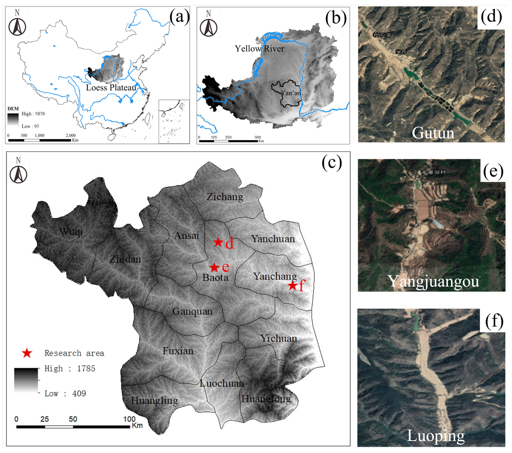
Yan’an City is located in the middle reaches of the Yellow River, which belongs to the hilly and gully region of the Loess Plateau (Figure 1). The terrain of Yan’an is high in the northwest and low in the southeast, with an average altitude of 1200 m. The climate of this region is semi-humid and semi-arid with an average annual precipitation of 390–700 mm and an average annual temperature of 7.8–10.6 °C. Since 2013, Yan’an has implemented the GLCP with a construction scale of 33,300 hectares, involving 13 districts and counties including Baota District, Yanchang County, and Yanchuan County. By the end of 2020, a series of engineering measures in Yan’an City had greatly improved the farmland production capacity, farmland quality, and land use efficiency in this region. Considering the terrain and landform of the GLCP area and the progress of engineering renovation, we chose the three typical project areas of Yangjuangou, Gutun, and Luoping as the research subjects, as they have strong representativeness and feasibility.
2.2. Data Sources
The basic data used in the research, such as the population, rural economy, and input-output of the agricultural section, were mainly from the Yan’an Statistical Yearbook and Yearbook of Yan’an. The total area of the project area, arable land area, total road length, and other data of each case study watershed were from the land use map and completion acceptance map of the project area. The standard sub-frame map and remote sensing image of the second land survey in the project area were taken as the base map. The ecological safety effects of the project were comprehensively evaluated based on the topographic information, the current factors of farmland water conservancy, the willingness of farmers to construct projects, as well as the requirements of relevant regulations and technical standards. From 2017 to 2019, a survey team was organized to carry out field surveys on the ecological safety status of the project areas several times to obtain relevant research data.
2.3. Methodology
The GLCP in Yan’an city is a systematic, comprehensive, and regional work, focusing on ecological safety effects including those of dam bodies, slopes, farmland and other aspects, and each aspect affects and restricts others. Thus, the FCE method was adopted to construct an ecological safety evaluation model to evaluate the ecological safety effects of GLCP, which included the following steps: the construction of a comprehensive index system, determination of the index weight, and establishment of an evaluation model.
2.3.1. Construction of the Index System
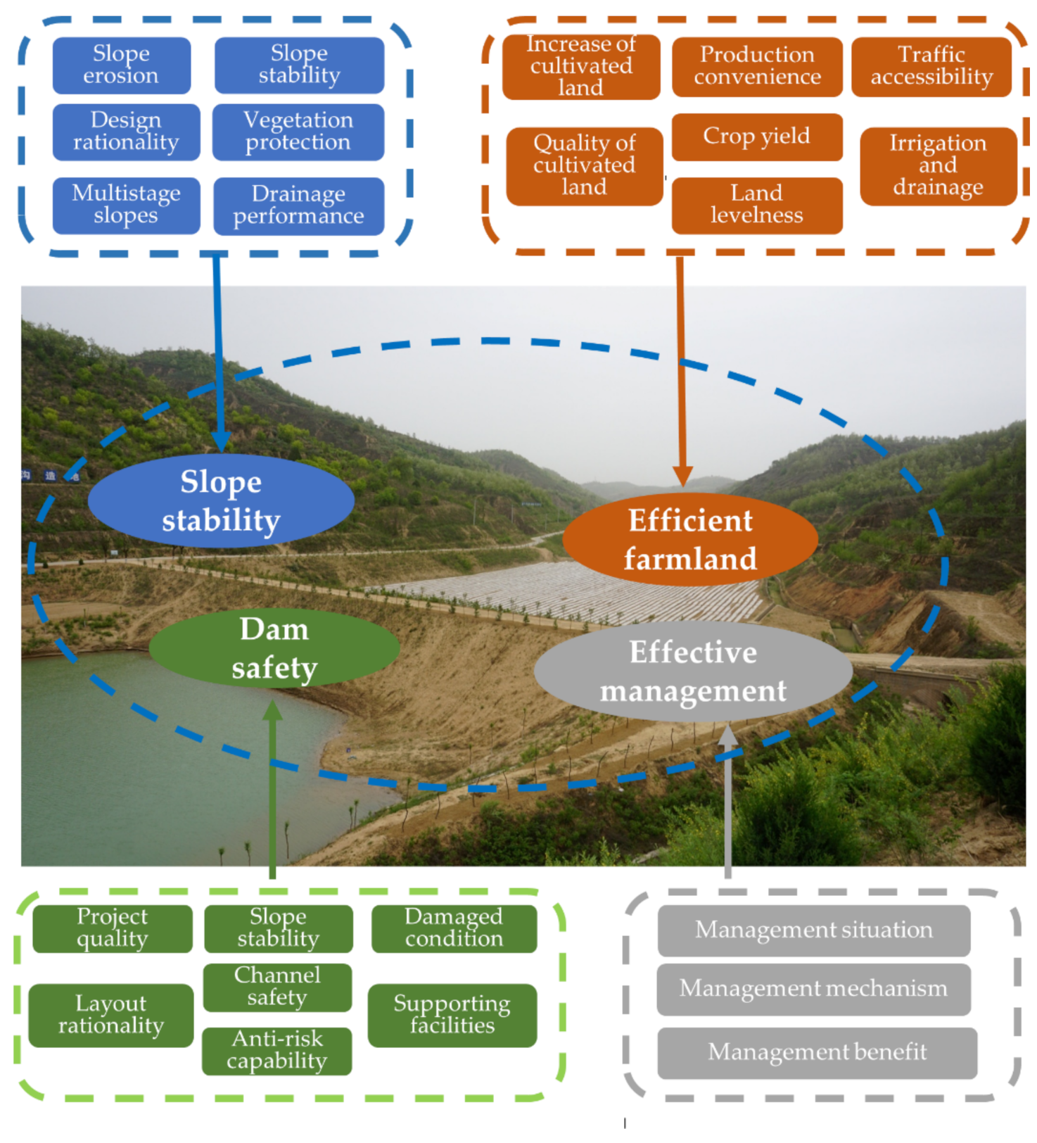
This study constructed an evaluation index system of ecological safety effects from the four aspects of dam safety, slope stability, efficient farmland, and effective management, and 23 relevant indicators were selected (Figure 2). The dam safety index mainly measured the construction stability of large, medium, and small dams, including project quality, layout rationality, anti-risk capability, damaged condition, channel safety, slope stability, and supporting facilities. The slope stability index mainly measured the stability of the newly added slopes and the vegetation protection condition, including design rationality, slope stability, vegetation protection, slope erosion, multistage slopes, and drainage performance. The efficient farmland index mainly measured the situation and stability of the newly added cultivated land, including increase of cultivated land, land levelness, quality of cultivated land, traffic accessibility, irrigation and drainage, crop yield, and convenience of production. The effective management index mainly refers to the management and protection situation after the GLCP, including management mechanism, management situation, and management benefit.
2.3.2. Determination of the Index Weight
The Analytic Hierarchy Process (AHP) was used to calculate the weight between each index [43]. Firstly, the Delphi method was used to make pairwise judgments between the indicators at the same level to form a comparison matrix of the importance of the indicators, where the importance comparison is obtained by the comparison scale method of 1–9. Secondly, the importance comparison matrix was used to calculate its maximum eigenvalue and the corresponding eigenvector to obtain the standard pair matrix. Then the arithmetic average of each row in the matrix was calculated to obtain the weight of each level factor. Finally, the consistency test was used to determine whether the obtained index weight value meets the requirements. The weight system of evaluation indexes in this paper is shown in Table 1.
2.3.3. Establishment of the Evaluation Model
This article mainly adopted the FCE method to construct the quantitative evaluation model. Fuzzy mathematics theory was used to assign evaluation objects according to different types and obtain different evaluation scores to achieve the purpose of artificial comprehensive evaluation. According to the engineering practice of the GLCP, the scoring standards of the secondary indicators were divided into five levels, which were excellent, good, fair, poor, and extremely poor. Accordingly, the evaluation scores of these five levels were assigned 0–2, 2–4, 4–6, 6–8 and 8–10 points. The higher the evaluation score, the better the ecological safety effect of this indicator, and the more beneficial it is to engineering safety and ecological protection. The fuzzy comprehensive evaluation model of ecological safety effect established in this paper is:
where m denotes the evaluation index; n denotes the engineering project area; B refers to the evaluation result vector of the ecological safety effect; W refers to the weight vector of the evaluation index; R refers to the fuzzy relation vector, that is, the average value of different indexes corresponding to the expert score.
3. Results
3.1. Evaluation Results of Ecological Safety Effects
Fuzzy comprehensive evaluation is a compound operation between the weight of each evaluation index and the value of the evaluation index. Operator M (·, +) was used for calculation. The weight matrix W1 was composed of the second-level index weights in Table 1, and the benefit value of the second-level index was composed of the single-factor benefit evaluation matrix R1. Thus, the evaluation values of dam safety of Yangjuangou, Gutun, and Luoping project areas were calculated:
B1G = W1·R1G = [0.545, 0.413, 0.399, 0.382, 0.342, 0.352, 0.331]
B1Y = W1·R1Y = [0.461, 0.340, 0.307, 0.297, 0.307, 0.289, 0.291]
B1L = W1·R1L = [0.333, 0.262, 0.254, 0.215, 0.230, 0.236, 0.196]
Similarly, the evaluation values of first-level evaluation indexes of slope stability, efficient farmland and effective management in different project areas were calculated:
B2G = W2·R2G = [0.396, 0.370, 0.390, 0.208, 0.404, 0.208]
B2Y = W2·R2Y = [0.308, 0.334, 0.348, 0.190, 0.345, 0.193]
B2L = W2·R2L = [0.237, 0.243, 0.263, 0.123, 0.243, 0.144]
B3G = W3·R3G = [0.233, 0.159, 0.137, 0.312, 0.257, 0.158, 0.238]
B3Y = W3·R3Y = [0.222, 0.158, 0.122, 0.279, 0.220, 0.143, 0.208]
B3L = W3·R3L = [0.205, 0.118, 0.099, 0.183, 0.185, 0.122, 0.155]
B4G = W4·R4G = [0.347, 0.317, 0.517]
B4Y = W4·R4Y = [0.302, 0.311, 0.432]
B4L = W4·R4L = [0.248, 0.204, 0.330]
In conclusion, the evaluation values of ecological safety effects in different project areas were calculated as follows:
BG = [2.764, 1.977, 1.495, 1.181]
BY = [2.292, 1.716, 1.353, 1.045]
BL = [1.726, 1.253, 1.066, 0.783]
3.2. Analysis of the First-Level Index of Ecological Safety Effects
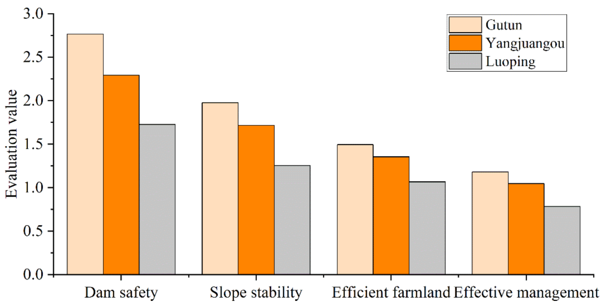
In general, Gutun had the highest evaluation value of ecological safety effects at 7.42, followed by Yangjuangou with a score of 6.41, and Luoping had the lowest score of only 4.83 (Figure 3). The evaluation scores of Gutun and Yangjuangou were significantly higher than that of Luoping, which shows that the ecological safety of Gutun and Yangjuangou was obviously better than that of Luoping. In terms of sub-indices, among the dam safety indicators, Gutun had the highest evaluation score (2.76), followed by Yangjuangou (2.29), and Luoping had the lowest score, with only 1.73. Among the slope stability indicators, Gutun had the highest evaluation score of 1.98, followed by Yangjuangou with 1.72, and Luoping had the lowest score of only 1.25. Among the efficient farmland indicators, Gutun has the highest evaluation score of 1.49, followed by Yangjuangou with 1.35, and Luoping had the lowest score of 1.07. Among the effective management indicators, Gutun’s evaluation score was the highest at 1.18, the next was Yangjuangou, at 1.05, and Luoping had the lowest score at 0.78.
3.3. Analysis of Secondary Index of Ecological Safety Effects
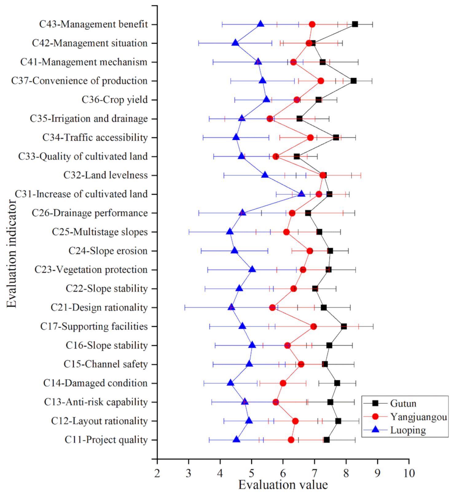
There are obvious differences among different project areas in the secondary index of ecological safety effects (Figure 4). The scores of Gutun in most secondary indexes were significantly higher, with an average value of 0.322. The second was Yangjuangou, with an average of 0.279. The score of Luoping was significantly lower than that of the other two project areas, with an average of 0.210. In terms of average value, Gutun was 16% higher than Yangjuangou, while Yangjuangou was 33% higher than Luoping, which indicated that the average values of both Gutun and Yangjuangou were significantly higher than that of Luoping. In addition, in terms of individual indicators, the average scores of irrigation and drainage, soil quality, design rationality, multistage slopes, drainage performance, and slope stability were relatively low, while the average scores of cultivated land area, convenience of production, management benefit, land levelness, and supporting facilities were relatively high.
In terms of the difference between Gutun and Yangjuangou, among the 13 indicators of dam safety and slope stability, Gutun scored significantly higher than the other two project areas, especially on the indexes of anti-risk capability, damaged condition, and layout rationality. In terms of efficient farmland and effective management, the difference between Gutun and Yangjuangou was relatively small on indicators such as cultivated land area, land levelness, management situation, etc. In terms of the difference between Yangjuangou and Luoping, it was obviously greater than that between Yangjuangou and Gutun. Especially on the indexes of dam supporting facilities, slope erosion, multistage slopes, and management situation, Yangjuangou scored significantly higher than Luoping. On the index of cultivated land area, the difference between Yangjuangou and Luoping was small—only 8%. The difference between Gutun and Luoping is concerned, the difference between them is the biggest. Especially in the dam damaged condition, traffic accessibility and other indicators, Gutun’s evaluation scores were even 70 percent higher than Luoping. However, in the index of cultivated land area, the difference between Gutun and Luoping is small—only 14%.
4. Discussion
4.1. Differentiation Analysis of Ecological Safety Effects
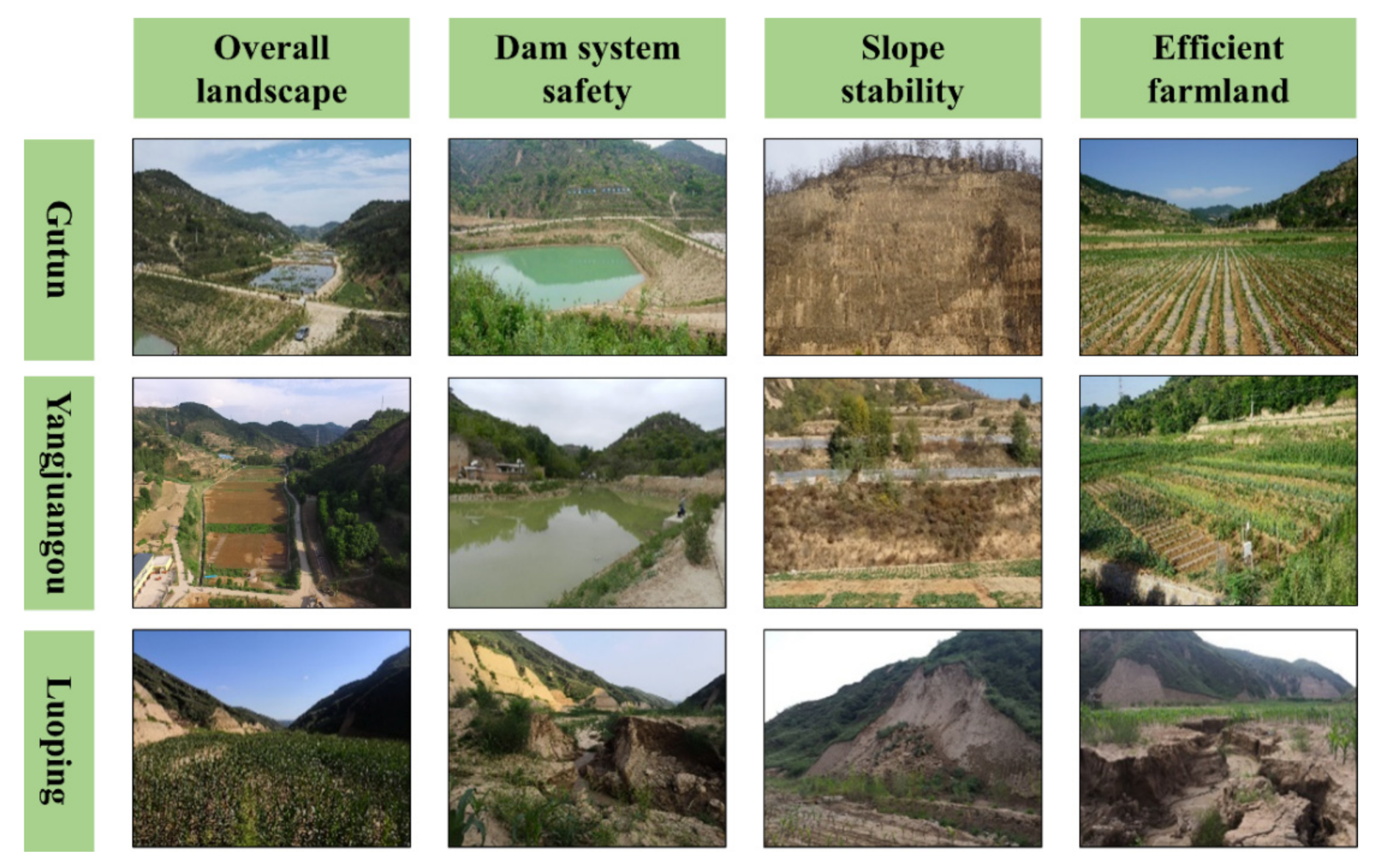
In general, the ecological safety effects of the GLCP in Gutun, Yangjuangou, and Luoping project areas showed obvious differences. Regardless of the overall indicators of comprehensive ecological safety effects, or the sub-indices such as dam safety, slope stability, efficient farmland, and effective management, Gutun’s evaluation scores were all significantly higher, which indicates that the local ecological safety effect of Gutun’s project was obviously better than that of the other two project areas (Figure 5). Through several field investigations in Gutun from 2017 to 2019, it was found that the cultivated land quality was improved by 2–3 levels and the crop yield was significantly increased after the GLCP, which effectively promoted the intensification of agricultural resources and provided favorable conditions for the development of modern agriculture including cropping pattern transformation, large-scale operation, and agricultural mechanization. After the implementation of the project, the average maize yield was about 11,250 kg/ha, nearly double that before the project implementation. At the same time, the agricultural landscape, supporting facilities, and other aspects of Gutun have been greatly improved. In addition, the Yangjuangou project area is close to urban area of Yan’an, and the overall situation of the project implementation was relatively good. The flatness of the cultivated land, the quality of the cultivated land and the convenience of agricultural production had been significantly improved, and it also had positive effect on the local ecological safety.
However, the ecological safety of Luoping was at a relatively poor level, and the ecological safety of gullies and slopes was facing serious threats. Based on the field survey carried out in 2018, it was found that some areas of the project had problems such as roads washed out, slope sliding, and farmland subsidence. Specifically, some agricultural roads had been severely damaged by rainfall, resulting in traffic difficulties. Some slopes near cultivated land had collapsed and slid, which affected the normal drainage function of the canal [44]. In addition, there were many rocks in the cultivated land after partial regulation, which seriously affected the growth and yield of field crops. What is more serious is that some dams washed out and collapsed after repeated rainfall, and faced great danger of further deterioration, which seriously affected the ecological safety of the project in Luoping project area.
The differences of ecological safety effects in different watersheds reflect the common problems of land consolidation projects. In general, a land consolidation project involves survey, planning, design, engineering construction, engineering supervision, follow-up management and other aspects. Different participants are often responsible for different stages, and the completion quality of the previous stage may affect the implementation and quality of the follow-up stages. This requires the effective connection of different stages and the cooperation of key participants. In the three watersheds, field research showed that the main reason for the difference of ecological safety effects lay in the difference of the completion quality of engineering construction, engineering supervision, and follow-up management.
4.2. Comprehensive Benefits and Improvement Suggestions
The GLCP can effectively solve the long-standing bottleneck of rural agricultural development, which is conducive to ensure a stable production environment in the gully (Figure 6). Firstly, the project can significantly promote appropriate-scale land management and modern agricultural development, by simultaneously improving the quantity, quality, and flatness of farmland, as well as the construction and improvement of agricultural production facilities. Secondly, the project can consolidate the achievements of the Grain-for-Green Project (GFGP) and provide better conditions for multi-functional agricultural development models such as “planting + breeding + sightseeing” mode, which can help increase the economic benefits of cultivated land and farmers’ income [45]. Finally, the project can significantly enhance the resistance of dam system to floods, and greatly enhance the ability to deal with the threats of climate change, such as extreme precipitation.
However, there may also be some problems in the implementation of the project. For example, some areas in Luoping have experienced poor soil quality of cultivated land, slope collapse, and erosion of silt dams, due to imperfect supervision mechanism, unclear main responsibility, and unqualified engineering technology. These problems have seriously affected local agricultural production and threatened the ecological safety of the project area. Therefore, there is an urgent need to take corresponding measures to effectively manage and restrict the implementation of engineering projects to ensure the quality of engineering construction and the safety of the regional ecological environment. Specific measures are as follows:
- (1)
- The legal and regulatory system for project quality supervision should be further improved, and a comprehensive project quality supervision mechanism should be established. In addition, the responsibilities of supervisory entities should be reasonably defined and clarified, and a responsive accountability system should be established to impose severe penalties on non-conforming projects.
- (2)
- It is necessary to improve the project quality supervision methods to increase the sense of participation of various entities in society in supervision and feedback [46]. Specifically, various entities should be organically integrated to improve the macro supervision of local government, the direct supervision of construction entities, and the timely feedback of social entities.
- (3)
- Follow-up investigations should be strengthened after the land consolidation project, and problems existing in the project construction should be fed back in time, so as to solve the problems in a targeted way and avoid the further deterioration of the project construction problems.
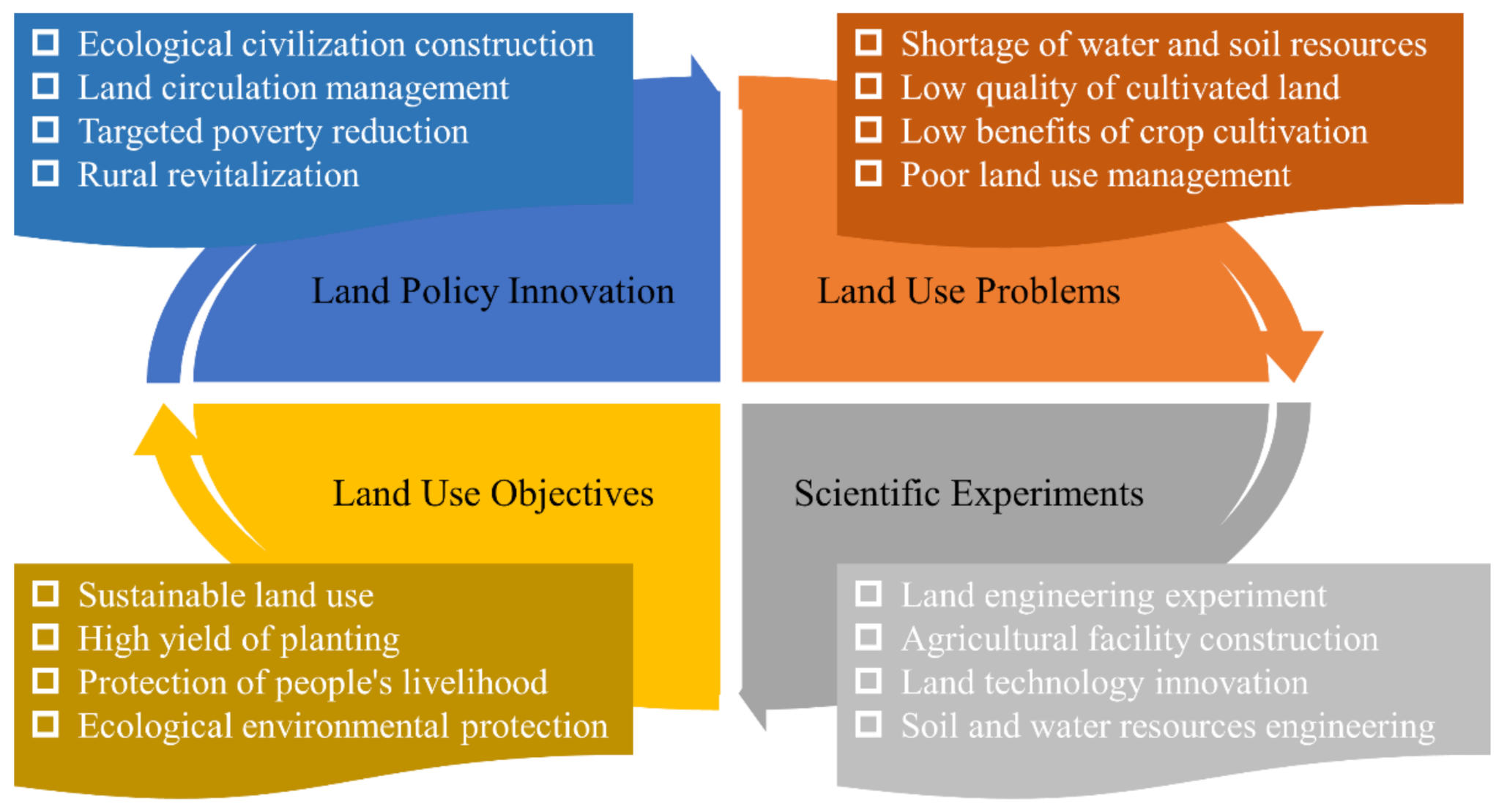
4.3. Implications for Land Policy Innovation
Since the beginning of the new century, with the rapid advancement of urbanization and the steady implementation of the GFGP, the land use pattern and the relationship between people and land in Yan’an have undergone tremendous changes. To make full use of the abundant channel resources and promote the development of modern agriculture, the local government implemented the GLCP to protect the ecology and benefit people’s livelihoods which, as well, brought about some problems. The proper settlement of regional agricultural problems is a comprehensive and systematic project, which needs to make overall plans for the diagnosis of land use problems, scientific experiments and remediation, sustainable land use, and land policy innovation [33] (Figure 7). For land use nature, management and technical issues, the government should attach importance to policy innovation on land technology innovation, land consolidation project, land circulation management, and so on [47]. In addition, the government should further strengthen the guiding and supporting role of land use policy innovation in ecological protection, economic development, and people’s livelihood security based on highlighting the key position of land use policy in national ecological civilization, targeted poverty alleviation, and rural revitalization [48,49].
Agricultural land consolidation engineering is the application of engineering and techniques to land use and development, which aims at increasing the amount of arable land, improving land use efficiency, and actively achieving a harmonious human-land relationship [50,51]. By combining theoretical and engineering technology research, it can effectively solve problems in regional agricultural development and support rural revitalization and modernization [52]. Facing the new era of agricultural supply-side reforms and agricultural and rural modernization strategies, relevant land policies should focus on technology research and development and coordination mechanism innovation for projects such as global land consolidation, agricultural resource utilization, and farmland system conservation [53].
5. Conclusions
Taking the GLCP in Yan’an City as an example, this study established a quantitative evaluation model for ecological safety effects from the four aspects of dam safety, slope stability, efficient farmland, and effective management, and scientifically determined the ecological safety effects of the renovation project.
(1) The ecological safety effects of the Gutun, Yangjuangou, and Luoping project areas show obvious differences. Regardless of the sub-indices such as dam safety, slope stability, efficient farmland and effective management, or the overall indicators of comprehensive ecological safety effects, Gutun’s evaluation scores were significantly higher than those of Yangjuangou and Luoping. After the implementation of GLCP, the agricultural production conditions have been greatly improved, and the comprehensive agricultural production capacity has been steadily improved, which is conducive to consolidating the results of returning farmland to forests, improving the basic level of agricultural development, and promoting harmony between man and land and the construction of ecological civilization.
(2) In general, agricultural land engineering is the key factor of modern agricultural development, ecological construction, and sustainable land use. It can solve land management spatial issues and is regarded as an indispensable method for land use transition and rural spatial restructuring [54,55]. However, our evaluation and investigation also showed that unreasonable engineering design and imperfect management mechanisms may have negative impacts on the ecological safety of the project area. This shows the need to strengthen the innovation of engineering technology, supervision of construction quality, and follow-up management and protection of the project.
(3) In recent years, lots of work on ecological protection and restoration has been highly valued all over the world under the background of climate change, and large-scale ecological construction projects have been widely implemented, gradually becoming a research hotspot. However, due to the fragile ecological background, poor site conditions, variable climatic conditions, imperfect management mechanisms and weak long-term observational research, these projects may face certain ecological safety issues after implementation. The effective implementation of engineering renovation requires further strengthening of engineering technology-related research and improvement of engineering supervision mechanisms. Therefore, there is an urgent need to carry out comprehensive and in-depth research on the ecological safety mechanism, process and effects of land use transitions promoted by land consolidation projects, so as to guide the implementation of the land consolidation projects from the perspective of ecological safety.
Author Contributions
Conceptualization, W.F. and Y.L.; methodology, W.F.; data analysis, W.F. and Y.L.; writing—original draft, W.F.; writing—review and editing, Y.L.; supervision, Y.L.; funding acquisition, W.F. and Y.L. Both authors have read and agreed to the published version of the manuscript.
Funding
This research was supported by National Key Research and Development Program of China, grant number 2017YFC0504701; National Natural Science Foundation of China, grant number 41931293 and 41801175; China Postdoctoral Science Foundation, grant number 2020M680658.
Institutional Review Board Statement
Not applicable.
Informed Consent Statement
Not applicable.
Data Availability Statement
Not applicable.
Acknowledgments
The insightful and constructive comments and suggestions from the three anonymous reviewers are greatly appreciated.
Conflicts of Interest
The authors declare no conflict of interest.
References
- Liu, Y.S.; Li, Y.H. Revitalize the world’s countryside. Nature 2017, 548, 275–277. [Google Scholar] [CrossRef] [PubMed]
- Chen, M.X.; Gong, Y.H.; Lu, D.D.; Ye, C. Build a people-oriented urbanization: China’s new-type urbanization dream and Anhui model. Land Use Policy 2019, 80, 1–9. [Google Scholar] [CrossRef]
- Deng, X.Z.; Huang, J.K.; Rozelle, S.; Zhang, J.P.; Li, Z.H. Impact of urbanization on cultivated land changes in China. Land Use Policy 2015, 45, 1–7. [Google Scholar] [CrossRef]
- Liu, Y.S.; Fang, F.; Li, Y.H. Key issues of land use in China and implications for policy making. Land Use Policy 2014, 40, 6–12. [Google Scholar] [CrossRef]
- Bai, X.M.; McPhearson, T.; Cleugh, H.; Nagendra, H.; Tong, X.; Zhu, T.; Zhu, Y.G. Linking urbanization and the environment: Conceptual and empirical advances. Annu. Rev. Environ. Resour. 2017, 42, 215–240. [Google Scholar] [CrossRef] [Green Version]
- Allahyari, M.S.; Damalas, C.A.; Masouleh, Z.D.; Ghorbani, M. Land consolidation success in paddy fields of northern Iran: An assessment based on farmers’ satisfaction. Land Use Policy 2018, 73, 95–101. [Google Scholar] [CrossRef]
- Janus, J.; Markuszewska, I. Forty years later: Assessment of the long-lasting effectiveness of land consolidation projects. Land Use Policy 2019, 83, 22–31. [Google Scholar] [CrossRef]
- Li, P.Y.; Qian, H.; Wu, J.H. Accelerate research on land creation. Nature 2014, 510, 29–31. [Google Scholar] [CrossRef]
- Feng, W.L.; Liu, Y.S.; Qu, L.L. Effect of land-centered urbanization on rural development: A regional analysis in China. Land Use Policy 2019, 87, 104072. [Google Scholar] [CrossRef]
- Liu, Y.S.; Feng, W.L.; Li, Y.R. Modern agricultural geographical engineering and agricultural high-quality development: Case study of loess hilly and gully region. Acta Geogr. Sin. 2020, 75, 2029–2046. [Google Scholar]
- Liu, Y.S.; Zhang, Z.W.; Wang, J.Y. Regional differentiation and comprehensive regionalization scheme of modern agriculture in China. Acta Geogr. Sin. 2018, 73, 203–218. [Google Scholar]
- Liu, Q.; Wang, Y.Q.; Zhang, J.; Chen, Y.P. Filling gullies to create farmland on the loess plateau. Environ. Sci. Technol. 2013, 47, 7589–7590. [Google Scholar] [CrossRef] [PubMed]
- Fu, B.J.; Wu, B.F.; Lu, Y.H.; Xu, Z.H.; Cao, J.H.; Niu, D.; Yang, G.S.; Zhou, Y.M. Three Gorges project: Efforts and challenges for the environment. Prog. Phys. Geogr. 2010, 34, 741–754. [Google Scholar] [CrossRef]
- Han, J.C.; Liu, Y.S.; Zhang, Y. Sand stabilization effect of feldspathic sandstone during the fallow period in Mu Us Sandy Land. J. Geogr. Sci. 2015, 25, 428–436. [Google Scholar] [CrossRef]
- Wang, Y.S.; Li, Y.H.; Liu, Y.S. China’s sandy land consolidation engineering and regional agricultural sustainable development practice under water resource constraint: Case study of Yulin city in Shaanxi province, China. Bull. Chin. Acad. Sci. 2020, 35, 1408–1416. [Google Scholar]
- Li, Y.R.; Li, Y.; Fan, P.C.; Long, H.L. Impacts of land consolidation on rural human-environment system in typical watershed of the Loess Plateau and implications for rural development policy. Land Use Policy 2019, 86, 339–350. [Google Scholar]
- Jin, Z. The creation of farmland by gully filling on the Loess Plateau: A double-edged sword. Environ. Sci. Technol. 2014, 48, 883–884. [Google Scholar] [CrossRef]
- Wang, Y.S.; Li, Y.H.; Liu, Y.S. Principle and method of modern agricultural two-dimension optimization engineering experiment. Eng. Sci. 2019, 21, 48–54. [Google Scholar]
- Wang, S.A.; Fu, B.J.; Piao, S.L.; Lu, Y.H.; Ciais, P.; Feng, X.M.; Wang, Y.F. Reduced sediment transport in the Yellow River due to anthropogenic changes. Nat. Geosci. 2016, 9, 38–41. [Google Scholar] [CrossRef]
- Li, Y.R.; Zhang, X.C.; Cao, Z.; Liu, Z.J.; Lu, Z.; Liu, Y.S. Towards the progress of ecological restoration and economic development in China’s Loess Plateau and strategy for more sustainable development. Sci. Total Environ. 2021, 756, 143676. [Google Scholar]
- Fu, B.J.; Wang, S.; Liu, Y.; Liu, J.B.; Liang, W.; Miao, C.Y. Hydrogeomorphic ecosystem responses to natural and anthropogenic changes in the Loess Plateau of China. Annu. Rev. Earth Planet. Sci. 2017, 45, 223–243. [Google Scholar] [CrossRef]
- Cao, Z.; Li, Y.R.; Liu, Y.S.; Chen, Y.F.; Wang, Y.S. When and where did the Loess Plateau turn “green”? Analysis of the tendency and breakpoints of the normalized difference vegetation index. Land. Degrad. Dev. 2018, 29, 162–175. [Google Scholar] [CrossRef]
- Cao, S.X.; Sun, G.; Zhang, Z.Q.; Chen, L.D.; Feng, Q.; Fu, B.J.; McNulty, S.; Shankman, D.; Tang, J.W.; Wang, Y.H.; et al. Greening China Naturally. Ambio 2011, 40, 828–831. [Google Scholar] [CrossRef] [Green Version]
- Liu, Y.S.; Li, Y.H. China’s land creation project stands firm. Nature 2014, 511, 410. [Google Scholar] [CrossRef] [PubMed]
- Liu, Y.S.; Li, Y.R. Engineering philosophy and design scheme of gully land consolidation in Loess Plateau. Trans. Chin. Soc. Agric. Eng. 2017, 33, 1–9. [Google Scholar]
- Han, Y.; Yu, C.Y.; Feng, Z.; Du, H.C.; Huang, C.S.; Wu, K.N. Construction and optimization of ecological security pattern based on spatial syntax classification—Taking Ningbo, China, as an Example. Land 2021, 10, 380. [Google Scholar] [CrossRef]
- Li, Z.T.; Yuan, M.J.; Hu, M.M.; Wang, Y.F.; Xia, B.C. Evaluation of ecological security and influencing factors analysis based on robustness analysis and the BP-DEMALTE model: A case study of the Pearl River Delta urban agglomeration. Ecol. Indic. 2019, 101, 595–602. [Google Scholar] [CrossRef]
- Long, H.L.; Qu, Y. Land use transitions and land management: A mutual feedback perspective. Land Use Policy 2018, 74, 111–120. [Google Scholar] [CrossRef]
- Gu, X.K.; Dai, B.; Chen, B.M. Landscape effects of land consolidation projects in Central China—A case study of Tianmen City, Hubei Province. Chin. Geogr. Sci. 2008, 18, 41–46. [Google Scholar] [CrossRef] [Green Version]
- Han, X.L.; Lv, P.Y.; Zhao, S.; Sun, Y.; Yan, S.Y.; Wang, M.H.; Han, X.N.; Wang, X.R. The effect of the Gully land consolidation project on soil erosion and crop production on a typical watershed in the Loess Plateau. Land 2018, 7, 113. [Google Scholar] [CrossRef] [Green Version]
- Hong, C.Q.; Jin, X.B.; Fan, Y.T.; Xiang, X.M.; Cao, S.; Chen, C.C.; Zheng, G.; Zhou, Y.K. Determining the effect of land consolidation on agricultural production using a novel assessment framework. Land Degrad. Dev. 2020, 31, 356–371. [Google Scholar] [CrossRef]
- Kolis, K.; Hiironen, J.; Riekkinen, K.; Vitikainen, A. Forest land consolidation and its effect on climate. Land Use Policy 2017, 61, 536–542. [Google Scholar] [CrossRef]
- Liu, Y.S. Integrated land research and land resources engineering. Resour. Sci. 2015, 37, 1–8. [Google Scholar]
- Cay, T.; Iscan, F. Fuzzy expert system for land reallocation in land consolidation. Expert Syst. Appl. 2011, 38, 11055–11071. [Google Scholar] [CrossRef]
- Cay, T.; Ayten, T.; Iscan, F. Effects of different land reallocation models on the success of land consolidation projects: Social and economic approaches. Land Use Policy 2010, 27, 262–269. [Google Scholar] [CrossRef]
- Guo, B.B.; Fang, Y.L.; Jin, X.B.; Zhou, Y.K. Monitoring the effects of land consolidation on the ecological environmental quality based on remote sensing: A case study of Chaohu Lake Basin, China. Land Use Policy 2020, 95, 104569. [Google Scholar] [CrossRef]
- Guo, B.B.; Jin, X.B.; Yang, X.H.; Guan, X.; Lin, Y.A.; Zhou, Y.K. Determining the effects of land consolidation on the multifunctionality of the cropland production system in China using a SPA-fuzzy assessment model. Eur. J. Agron. 2015, 63, 12–26. [Google Scholar] [CrossRef]
- Liu, Y.S.; Guo, Y.J.; Li, Y.R.; Li, Y.H. GIS-based effect assessment of soil erosion before and after gully land consolidation: A case study of Wangjiagou project region, Loess Plateau. Chin. Geogr. Sci. 2015, 25, 137–146. [Google Scholar] [CrossRef] [Green Version]
- Zhu, G.M.; Li, D.L. A method for land consolidation progress assessment based on GPS and PDA. Math. Comput. Sci. Eng. 2009, 8, 429–438. [Google Scholar]
- Lu, S.S.; Li, J.P.; Guan, X.L.; Gao, X.J.; Gu, Y.H.; Zhang, D.H.; Mi, F.; Li, D.D. The evaluation of forestry ecological security in China: Developing a decision support system. Ecol. Indic. 2018, 91, 664–678. [Google Scholar] [CrossRef]
- Yang, Y.; Cai, Z.X. Ecological security assessment of the Guanzhong Plain urban agglomeration based on an adapted eco-logical footprint model. J. Clean. Prod. 2020, 260, 120973. [Google Scholar] [CrossRef]
- Gong, L.; Jin, C.L. Fuzzy comprehensive evaluation for carrying capacity of regional water resources. Water Resour. Manag. 2009, 23, 2505–2513. [Google Scholar] [CrossRef]
- Pang, Y.J.; Liu, L.M.; Li, W.G. Fuzzy comprehensive evaluation model of ecological security based on distinguishable weight of indexes. Prog. Environ. Sci. Technol. 2009, 51(Pts A and B), 99–103. [Google Scholar]
- He, C.X. The present situation, characteristics and functions of the project of treating ditches and constructing land in Yan’an. J. Earth Environ. 2015, 15, 255–260. [Google Scholar]
- Liu, Y.S.; Chen, Z.F.; Li, Y.R. The planting technology and industrial development prospects of forage rape in the loess hilly area: A case study of newly-increased cultivated land through gully land consolidation in Yan’an, Shaanxi Province. J. Nat. Resour. 2017, 32, 2065–2074. [Google Scholar]
- Gedefaw, A.A.; Atzberger, C.; Seher, W.; Mansberger, R. Farmers willingness to participate in voluntary land consolidation in Gozamin District, Ethiopia. Land 2019, 8, 148. [Google Scholar] [CrossRef] [Green Version]
- Long, H.L.; Li, Y.R.; Liu, Y.S.; Woods, M.; Zou, J. Accelerated restructuring in rural China fueled by ‘increasing vs. decreasing balance’ land-use policy for dealing with hollowed villages. Land Use Policy 2012, 29, 11–22. [Google Scholar] [CrossRef]
- Li, Y.R.; Liu, Y.S.; Long, H.L.; Cui, W.G. Community-based rural residential land consolidation and allocation can help to revitalize hollowed villages in traditional agricultural areas of China: Evidence from Dancheng County, Henan Province. Land Use Policy 2014, 39, 188–198. [Google Scholar] [CrossRef]
- Zhu, M. New development of agricultural engineering in China. Trans. Chin. Soc. Agric. Eng. 2005, 21, 1–11. [Google Scholar]
- Feng, W.L.; Liu, Y.S.; Chen, Z.F.; Li, Y.R.; Huang, Y.X. Theoretical and practical research into excavation slope protection for agricultural geographical engineering in the Loess Plateau—A case study of China’s Yangjuangou catchment. J. Rural Stud. 2019, 8, 18–23. [Google Scholar] [CrossRef]
- Jin, X.B.; Shao, Y.; Zhang, Z.H.; Resler, L.M.; Campbell, J.B.; Chen, G.; Zhou, Y.K. The evaluation of land consolidation policy in improving agricultural productivity in China. Sci. Rep. 2017, 7, 2792. [Google Scholar] [CrossRef] [PubMed] [Green Version]
- Han, J.C.; Zhang, Y. Land policy and land engineering. Land Use Policy 2014, 40, 64–68. [Google Scholar] [CrossRef]
- Lu, D.D.; Liu, Y.S.; Fang, C.L.; Chen, M.X.; Wang, J.E.; Xi, J.C. Development and prospect of human-economic geography. Acta Geogr. Sin. 2020, 75, 2570–2592. [Google Scholar]
- Colombo, S.; Manuel, P.V. A practical method for the ex-ante evaluation of land consolidation initiatives: Fully connected parcels with the same value. Land Use Policy 2019, 81, 463–471. [Google Scholar] [CrossRef]
- Long, H.L.; Tu, S.S.; Ge, D.Z.; Li, T.T.; Liu, Y.S. The allocation and management of critical resources in rural China under restructuring: Problems and prospects. J. Rural. Stud. 2016, 47, 392–412. [Google Scholar] [CrossRef] [Green Version]
Figure 1.
Location of Yan’an City (a–c) and the general situation of Gutun, Yangjuangou, and Luoping (d–f).
Figure 1.
Location of Yan’an City (a–c) and the general situation of Gutun, Yangjuangou, and Luoping (d–f).

Figure 2.
Index selection of ecological security effects and its main connotation.

Figure 3.
Evaluation value of the first-level indexs of ecological safety effects in different gully land consolidation project (GLCP) area.
Figure 3.
Evaluation value of the first-level indexs of ecological safety effects in different gully land consolidation project (GLCP) area.

Figure 4.
Evaluation value of the secondary indexs of ecological safety effects in different GLCP area.
Figure 4.
Evaluation value of the secondary indexs of ecological safety effects in different GLCP area.

Figure 5.
Differentiation analysis of the ecological safety effects in different GLCP area.

Figure 6.
Comprehensive benefits of the GLCP to regional development.

Figure 7.
Logical diagram of land use management, engineering, and policy.


Table 1.
Index weight of the evaluation index system.
| Criteria | First-Level Weight | Index | Second-Level Weight | Combined Weight |
|---|---|---|---|---|
| Dam safety (B1) | 0.35 | Project quality (C11) | 0.22 | 0.077 |
| Layout rationality (C12) | 0.15 | 0.053 | ||
| Anti-risk capability (C13) | 0.15 | 0.053 | ||
| Damaged condition (C14) | 0.13 | 0.046 | ||
| Channel safety (C15) | 0.12 | 0.042 | ||
| Slope stability (C16) | 0.12 | 0.042 | ||
| Supporting facilities (C17) | 0.11 | 0.039 | ||
| Slope stability (B2) | 0.28 | Design rationality (C21) | 0.2 | 0.056 |
| Slope stability (C22) | 0.2 | 0.056 | ||
| Vegetation protection (C23) | 0.2 | 0.056 | ||
| Slope erosion (C24) | 0.1 | 0.028 | ||
| Multistage slopes (C25) | 0.2 | 0.056 | ||
| Drainage performance (C26) | 0.1 | 0.028 | ||
| Efficient farmland (B3) | 0.22 | Increase of cultivated land (C31) | 0.15 | 0.033 |
| Land levelness (C32) | 0.1 | 0.022 | ||
| Quality of cultivated land (C33) | 0.1 | 0.022 | ||
| Traffic accessibility (C34) | 0.2 | 0.044 | ||
| Irrigation and drainage (C35) | 0.2 | 0.044 | ||
| Crop yield (C36) | 0.1 | 0.022 | ||
| Convenience of production (C37) | 0.15 | 0.033 | ||
| Effective management (B4) | 0.15 | Management mechanism (C41) | 0.3 | 0.045 |
| Management situation (C42) | 0.3 | 0.045 | ||
| Management benefit (C43) | 0.4 | 0.060 |
Publisher’s Note: MDPI stays neutral with regard to jurisdictional claims in published maps and institutional affiliations. |
© 2021 by the authors. Licensee MDPI, Basel, Switzerland. This article is an open access article distributed under the terms and conditions of the Creative Commons Attribution (CC BY) license (https://creativecommons.org/licenses/by/4.0/).
Share and Cite
MDPI and ACS Style
Feng, W.; Li, Y. Measuring the Ecological Safety Effects of Land Use Transitions Promoted by Land Consolidation Projects: The Case of Yan’an City on the Loess Plateau of China. Land 2021, 10, 783. https://doi.org/10.3390/land10080783
AMA Style
Feng W, Li Y. Measuring the Ecological Safety Effects of Land Use Transitions Promoted by Land Consolidation Projects: The Case of Yan’an City on the Loess Plateau of China. Land. 2021; 10(8):783. https://doi.org/10.3390/land10080783
Chicago/Turabian StyleFeng, Weilun, and Yurui Li. 2021. "Measuring the Ecological Safety Effects of Land Use Transitions Promoted by Land Consolidation Projects: The Case of Yan’an City on the Loess Plateau of China" Land 10, no. 8: 783. https://doi.org/10.3390/land10080783
Note that from the first issue of 2016, this journal uses article numbers instead of page numbers. See further details here.