Article

Approaching Sea-Level Rise (SLR) Change: Strengthening Local Responses to Sea-Level Rise and Coping with Climate Change in Northern Mozambique

by
Serafino Afonso Rui Mucova
1,2,*,
Ulisses Miranda Azeiteiro
2,
Walter Leal Filho
3,4,
Carina Lurdes Lopes
5,6,
João Miguel Dias
5 and
Mário Jorge Pereira
2
1
Faculty of Natural Sciences, Lúrio University, 958 Pemba, Mozambique
2
Department of Biology & CESAM (Center for Environmental and Marine Studies), University of Aveiro, 3810-193 Aveiro, Portugal
3
Research and Transfer Centre “Sustainability and Climate Change Management”, Faculty of Life Sciences, Hamburg University of Applied Sciences, D-21033 Hamburg, Germany
4
School of Science and the Environment, Manchester Metropolitan University, Manchester M15 6BH, UK
5
Center for Environmental and Marine Studies, Department of Physics & CESAM, University of Aveiro, 3810-193 Aveiro, Portugal
6
Marine and Environmental Sciences Centre, Faculty of Sciences & MARE, University of Lisbon, 1749-016 Lisboa, Portugal
*
Author to whom correspondence should be addressed.
J. Mar. Sci. Eng. 2021, 9(2), 205; https://doi.org/10.3390/jmse9020205
Submission received: 21 January 2021 / Revised: 8 February 2021 / Accepted: 10 February 2021 / Published: 16 February 2021
(This article belongs to the Special Issue Sea Level Rise: Drivers, Variability and Impacts)

Abstract

:
Mean sea-level is expected to rise significantly by 2100 in all scenarios, including those compatible with the objectives of the Paris Climate Agreement. Global sea level rise projections indicate devastating implications for populations, ecosystem services and biodiversity. The implications of the sea-level rise (SLR) on low-lying islands and coastal regions and communities are substantial and require deep-rooted coping measures. In the absence of adequate responses for coping, Mozambique is expected to record huge losses, with an impact on the economy and development in many sectors of its coastal regions mainly in northern Mozambique. This research aimed to perform projections on SLR in Mozambique, and to understand its role and implications on the north coast of the country. SLR was estimated through the analysis of model outputs that support the global estimates of the fifth IPCC report near the Mozambican coast, for each of the four representative concentration pathways (RCPs) scenarios. Regional coastline retreat and coastal erosion were estimated through the results of global sandy coastlines projections developed by Vousdoukas. Mean sea-level rise projections indicate that regional estimates for the Mozambican coast are relative higher than global estimates (~0.05 m) for all representative concentration pathways (RCPs). Yet, we highlight significant differences in sea-level rises of 0.5 m, 0.7 m or 1.0 m by 2100 compared to the global mean. It is expected that with the increase in the mean sea level in the northern part of the Mozambican coast, erosive effects will increase, as well as the retreat of the coastline until 2100. With this, the tourism sector, settlements, ecosystem services and local populations are expected to be significantly affected by 2050, with increased threats in 2100 (RCP4.5, RCP8.5). Local responses for coping are proposed and properly discussed for the RCP4.5 and RCP8.5 scenarios through 2100.

1. Introduction

The potential impact and consequences of sea-level rise (SLR) on low-lying islands and coastal regions and communities mean that this is an urgent matter that requires deep-rooted coping measures. According to the [1], the global mean sea level (GMSL) is rising (with a 99 to 100% probability) and accelerating (high confidence). The tide gauges and altimetry observations analysis show an increase from 1.4 mm yr−1 over the period 1901–1990 to 2.1 mm year−1 over the period 1970–2015, to 3.2 mm year−1 over the period 1993–2015 and to 3.6 mm year−1 over the period 2006–2015 [2,3] The thermal expansion, ocean dynamics, melting of glaciers and ice sheets, and land water storage changes are considered predominant factors for global mean sea level (GMSL) rise [2].
GMSL projections indicate worrying scenarios. By 2100, mean sea level is expected to increase substantially under all scenarios, including those compatible with the long-term Paris Climate Agreement goals (likely range, indicative of the central 66% percentile range of projections). GMSL will raise between 0.84 m (0.61–1.10 m) under the representative concentration pathway (RCP) 8.5, and 0.43 m (0.29–0.59 m) under RCP2.6 relative to 1986–2005 [1,2,4,5]. Yet, under RCP8.5, the rate of sea-level rise will be 15 mm year−1 (10–20 mm year−1), that may be reduced in the implementation transformative mitigation measures (RCP2.6) by 2100 [1].
However, by the absence of effective adaptation measures compatible with current climate trajectories, more intense and frequent extreme sea-level events, together with social and economic pressures on the coastal regions will increase. Expected annual flood damages may grow by 2 to 3 orders of magnitude by 2100 [2].
Nevertheless, by means of moderate greenhouse gas (GHG) mitigation efforts, around 42 m of global sandy beach width could be preserved by 2100. Additionally, they could prevent about 17% of the global projected shoreline retreat by 2050 and 40% by 2100 [6]. Additionally, by 2100, half of the world’s sandy beaches could be depleted [6].
Likewise, the erosion, loss and change of coastal ecosystems, and enhanced coastal erosion, flooding and salinization are expected to increase significantly [1,2,7]. There is high confidence that extreme sea-level events will become more frequent and intense by 2100. These will be present in almost low-lying coastal megacities and small islands between 2050 and 2100 [2].
The 2014 IPCC report notes that the low-lying coastal zone is currently home to around 680 million people (~10% of the 2010 global population), projected to reach more than one billion by 2050 [1]. Thus, around 190 million people currently occupy global land below projected high-tide lines for 2100 (RCP2.6), and 630 million people live on land below projected annual flood levels for 2100 (RCP8.5) [8]. Additionally, one billion people now occupy land less than 10 m above current high-tide lines [8], and coastal storms are causing damages in the order of tens of billions of US$ per year [9].
Potential impacts of GMSL threaten people’s lives and livelihoods, especially those in coastal communities and low-lying inlands. There is high confidence that the coastal infrastructure, community livelihoods, agriculture and habitability will be some of the most affected assets [1,6,10,11].
Thus, altered freshwater and sediment availability [2], rapidly modified coastlines [1], seawall and coastal defense decreases [11], higher and more frequent storm surges [12], modification of river and catchment floods [13], saltwater intrusion [14], significant losses of biodiversity and ecosystem services [15,16], and landward advance [17] are the most prevalent risks by 2100. Developing countries will be severely devastated and accompanying economic and ecological damage will be severe for many [18].
Based on this, two dramatic paths must be planned as solutions to prevent a likely regional and local catastrophe:
(a)
Considerably reducing greenhouse gas emissions, and complying with the Paris Climate Agreement; and
(b)
Introducing transformative responses and adaptation measures, and fully complying with sustainable development goals.
However, the operationalization of promising responses at regional and local scales, especially in the context of the GMSL, must require very different regional and local capacities for coping [1,19]. Thus, it is assumed that a considerable amount of local scientific information on GMSL is primarily guaranteed. In the absence of this information, it is anticipated that many local efforts and attempts to cope may result in huge economic, social and investment losses. Mozambique is one of the African countries with the greatest shortage of scientific information on GMSL. In addition, it is one of the southern African countries most affected by the impacts of climate change and natural disasters. The country has a high level of vulnerability and a low level of readiness. In the global ranking, Mozambique is the 39th most vulnerable country and the 24th least prepared country in the world. Additionally, it is highly exposed to erosion risks and coastal climate hazards [20].
Mozambique has 2470 km of coastline, and more than 60% of the population lives in low-lying coastal areas. Moreover, 45% of the population lives below the poverty line and 70% depends on climate-sensitive living conditions [21].
Historically, the level of damage and number of deaths caused by weather-related events has significantly affected the Mozambican economic development. During the year 2000, the country suffered one of the largest and most devastating disasters caused by weather events (a combination of floods and cyclones). Approximately 700 people died, 500,000 people were displaced, 12% of crops were devastated, and the damages amounted to more than $600 million [22]. Nineteen years later, during the year 2019, it was again severely devastated by two consecutive tropical cyclones (the Idae Tropical Cyclone in March, and the Kenneth Tropical Cyclone in April).
On average, 1.5 cyclones hit Mozambique during the annual cyclone season [23]. According to the World Meteorological Organization, Mozambique has not experienced two high-intensity cyclones within the same season before [24], and both caused massive flooding on the northern and central Mozambique coast (Figure 1).
Moreover, more than 700 people died, 1641 people were injured, 274,585 families and 1,416,024 people were affected, 3344 classrooms were damaged, 262,120 students were affected, 53 hospitals were destroyed, 97,276 (ha) of crops were totally destroyed, 85,260 (ha) of crops were partially destroyed, 55,463 houses were destroyed, 15,784 houses were flooded, and the damages amounted to more than $1 billion.
The impacts of SLR and the 10% future intensification of storm surges will significantly increase the potential for inundation and occurrence of notable damages on the Mozambique coast [18].
Thereof, there is expected to be an incremental impact loss of 1318 km2 wetland, assuming that about 45% of coastal wetlands are affected. Yet, 78 km2 of urban land (about 55% of coastal urban land), 3268 km2 of land area (about 40% of coastal land area), 291 km2 of agricultural land (about 24% of coastal agricultural land), 380,000 people (about 51% of the coastal population), and finally, about US$140 million GDP (55% of coastal GDP) could be lost [18].
Parallel research finds that an estimated 4850 km2 of land could be lost by 2040. Additionally, by the 2040s damage to transportation and infrastructure in coastal areas could rise to $103 million per year [21,25,26,27,28]. However, in addition to the generalized limitation of information on SLR in the country, they know little about understanding the role of SLR in northern Mozambique. Indeed, we are confident that a detailed understanding on the topic will be powerful and essential to formulating an efficient, proactive, and transformative local response.
One of the fundamental questions for Mozambique is not simply informing how many centimeters more sea level on the country’s coast is expected to rise in the near future, but how to translate and explain the possible practical and local significance of this increase. If current efforts are aimed at eliminating risks, reducing exposure, as well as the impacts of rising sea levels on the Mozambican coast, it is important that the local community, governments, academics, and decision-makers clearly understand the meaning of the projections in their different scenarios. In this context, translating the projections of rising sea level into the potential risk of exposure and implications for populations, biodiversity, habitability, and ecosystem services is critical and fundamental for coastal planning and for the assessment of the costs and benefits of adaptation measures. To address this gap, this paper aims to model SLR on the coast of Mozambique, and particularly in northern Mozambique. Additionally, it aims to understand the role and implications of SLR for ecosystems, populations, biodiversity, ecosystem services and local infrastructure. Moreover, local responses to strengthen actions to adapt to the impacts of SLR in northern Mozambique are discussed.

2. Material and Methods
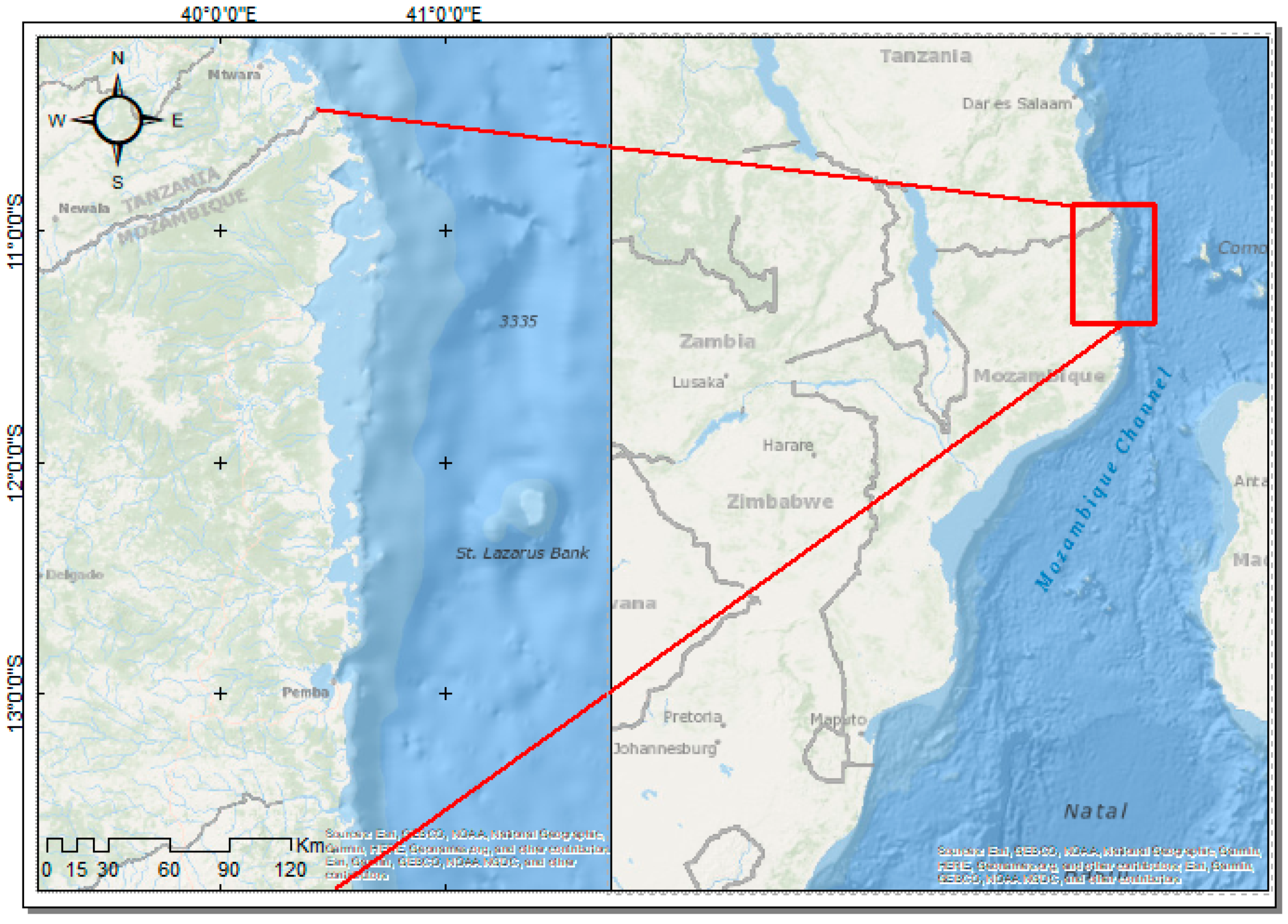
2.1. Study Area

Mozambique has the longest coastline in eastern Africa (Figure 2). Its geology is characterized by presenting two sedimentary basins, namely: (1) the southern basin that corresponds to the central and southern zone of Mozambique; and (2) the Rovuma basin that occupies the area narrow coastline of Nampula Province, becoming broader in a northerly direction, from the Lúrio river to the Rovuma river, in Cabo Delgado Province (our study area). This basin consists of the sedimentary deposits from the Meso-Cenozoic period, aged between Cretaceous and mid-Pliocene period [29].
Nevertheless, the morphology of the Mozambique coast is characterized by low areas, with an altitude up to 200 m above mean sea level, while the coastline of the northern country is generally characterized by intermittent stretches of sandy beaches, recent dunes, lagoons, coral reefs, mangrove swamps, coastal bays, and islands. Yet, they are characterized by presenting lands of volcanic islands that mark the border between the sea and the land [29].
The country’s coastal zone encompasses nine of the country’s eleven provinces, namely: Cabo Delgado, Niassa, Nampula, Zambézia, Sofala, Inhambane, Gaza, Maputo Province, and Maputo City. In addition, 40 of the 128 districts, and 10 of the 23 cities in the country are located within the coastal zone, which implies that about 60% of the Mozambican population lives in these regions. Therefore, extreme events from the Indian Ocean and SLR compromise the infrastructure, livelihoods, populations, coastal agriculture, key ecosystems, and fisheries. The northern region of Mozambique consists of three provinces—Nampula, Cabo Delgado and Niassa. However, only two (Cabo Delgado and Nampula) are part of Mozambique’s coastal zone. Northern Mozambique has Africa’s largest coastal marine reserve (comprising ten islands and featuring abundant coral and marine turtle species) [30]. Our study focused on the province of Cabo Delgado. This province is simultaneously the fourth most populous (2,333,278 inhabitants, about 8.36% of the Mozambique population) and extensive (82,625 km2, corresponding to about 10.30% of the national territory) in Mozambique. Four extremes limit the province to other regions: the Rovuma River and the Republic of Tanzania border it on the north; to the west are the Lugenda River and the Niassa province; To the south are the Lúrio River and the Nampula province; to the east, the Indian Ocean.
A tropical climate characterizes this province. The hot and rainy season is from November to April, while the dry and cool season is from May to October. The average annual temperature is 25 °C, while the average annual precipitation is 900 mm. The coast of Cabo Delgado province is one of the richest in ecosystem resources and services at the national level, as well as the coastal zone of Africa. It presents a high potential for mangrove distribution [31], has an abundance of coastal fishery resources [32], a high potential for the provision of ecosystem services (coastal tourism, coastal recreation, mariculture, carbon sequestration and protection [33], an abundance and diversity of coral reefs [34,35], a diversity of sea turtles [36,37], vast areas of beaches [38], as well as a large amount of gas and oil reserves.

2.2. Methods

Mean sea level changes have non-uniform patterns due to many local factors, such as land subsidence and non-uniform thermal expansion and salinity of ocean waters. In this way, there are regions where the mean sea level is raising several times more than the global average, while in other locations the mean sea level is decreasing. The local detailed characterization of mean sea level changes along coastlines is therefore essential when aiming to assess the shoreline evolution within a climate change context.
The mean sea level change along the Mozambican coast was estimated through the analysis of model outputs that support the global estimates of the fifth IPCC (Intergovernmental Panel on Climate Change) report near the Mozambican coast [39], for each of the four representative concentration pathway (RCP) scenarios [40].
The RCPs are scenarios that include time series of emissions and concentrations of the full suite of GHGs and aerosols and chemically active gases [1]. In this context, RCP2.6 represents a low greenhouse gas emission and high mitigation future, which, in Coupled Model Intercomparison Project Phase 5 (CMIP5) simulations, gives a two-in-three chance of limiting global warming to below 2 °C by 2100. By contrast, RCP8.5 is a high greenhouse gas emissions scenario in the absence of policies to combat climate change. Finally, RCP4.5 and RCP6.0 are considered intermediate levels of greenhouse gas emissions and result in intermediate levels of warming [1].
More specifically, this study uses the relative sea-surface height ensemble mean of 21 CMIP5 AOGCMs (Atmosphere–Ocean General Circulation Models) that support the global estimates of the fifth IPCC report. These data are accessible through the LAS (Live Access Server) interface of the Integrated Climate Data Center (ICDC) of the University of Hamburg (https://icdc.cen.uni-hamburg.de/1/daten/ocean/ar5-slr.html accessed on 21 January 2021). This data has 1° of spatial resolution and corresponds to the difference between the 2081–2100 mean and the 1980–2005 mean.
For each RCP scenario, the sea level change spatial variability was investigated in the Mozambican coast. Then, mean sea-level rise projections were determined by averaging the ensemble mean around the Mozambican coast. Besides the ensemble mean, the likely range was determined by averaging the ensemble lower and upper limits for a 90% confidence level. The likely range was defined in the fifth IPCC report and combines the uncertainty in global climate change, with the uncertainties in modelling represented by the CMIP5 ensemble [39].
Simultaneously, supported by the findings of regional SLR, we developed an exercise to understand the impacts and risks of sea-level rise for the periods 2050–2100 (RCP4.5 and 8.5) in northern Mozambique. Although our analysis focused on the four SLR scenarios (Table 1), two scenarios (RCP4.5 and 8.5) were used to support regional estimates of shoreline retreat and erosion (and their implications). However, in addition to these scenarios being commonly discussed and described in the current context of the SLR [1,2], we intended to match them to those used by [6] (global sandy coastline projections), which would allow us to extract estimates of the shoreline retreat and erosion to the regional scale.
To do this, first, we focused on assessing the dynamics of the coastline (sandy shorelines change) based on the outputs of the global projections of sandy shorelines/coastlines (source and extended data are available at https://cidportal.jrc.ec.europa.eu/ftp/jrc-opendata/LISCOAST/GlobalErosionProjectionsDataset/LATEST/globalErosionProjections.zip) [41]. These projections were developed by [6]) and published by Nature Climate Change (https://doi.org/10.1038/s41558-020-0697-0). The authors estimated their projections under RCPs4.5 and 8.5 for the years 2050 and 2100. However, although they presented estimated results to increase uncertainties, nevertheless not described in detail in the study, we decided to approach our findings from a more precautionary perspective, adding the uncertainty rates of 20% [42]. The authors [42] emphasize that in sandy shoreline analyses it is essential to consider uncertainties ranging between 20 to 40%. Thus, we estimate shoreline retreat due to the SLR (meters) and erosive trend (meters) for cost and north Mozambique (Table 2). Based on estimated data on rising sea level, as well as shoreline retreat and erosive trend (meters), we developed an analysis to understand how the projected dynamics would affect the environment/biophysical indicators (people, infrastructure, habitability, habitats, biodiversity, and ecosystem services). The information on the environment/biophysical indicators was compiled through a literature review process available for the region. As a result, we have analyzed implications, risks that may be affected by the SLR between 2050 and 2100 in northern Mozambique.
For a better understanding of the coastal dynamics and proposed procedures, we emphasize and underline that the natural characteristic of sandy lands, as well as sandy beaches, is to change shape constantly due to various natural and anthropogenic factors. Thus, the movement or changes of the coast towards the land is called a shoreline retreat (geometric projection based on slope), while, towards the sea, it is known as shoreline advance [43,44].
While shoreline erosion (erosive trend) is a change in the coastal/beach morphology over time (coastal morphodynamics/erodibility of the shoreline), it is derived from several natural and anthropogenic factors [45].

3. Results

3.1. Projections of the Sea-Level Rise under Four RCP Scenarios in the Northern Mozambique/Cabo Delgado

Figure 3 represents the spatial pattern of sea level change for 2081 to 2100 for each RCP, comparing to the 1980 to 2005 data. For all scenarios, a rise in mean sea level was observed, indicating that mean sea level will rise independently on the RCP scenario considered. Results also evidence that the mean sea level spatial variability along the Mozambican coast is very weak, not exceeding 0.05 m. According to this, the mean sea level change for the entire Mozambican coast can be considered as the mean value of the grid points represented in Figure 3.
Mean sea-level rise projections in this study (Table 1) indicate that regional estimates for the Mozambican coast are higher than global estimates (~0.05 m) for all RCPs, highlighting that local factors increase the rate of the mean sea-level rise along the Mozambican coast. Results further evidence higher uncertainty on regional estimates than on global ones. This fact was already identified by [46] when they analyzed the rates of future sea-level rise on regional scales in a 40-member ensemble of climate change projections, highlighting that these uncertainties are due to generated trends in large-scale wind patterns and changes in buoyancy forcing.
Using these results, three reliable scenarios were defined for the Mozambican coast assuming that the mean sea level may rise by 0.50 m, 0.70 m, or 1.00 m. The 0.50 m estimate is representative of the likely projection for scenarios RCP2.6, RCP4.5, and RCP6.0, while the 0.70 m estimate is representative of the likely projection for RCP8.5. The 1.00 m estimate is the most pessimistic, corresponding to the worst scenario, found for the upper limit of the RCP8.5 projection.
Our estimate shows that with the increase in the average sea level in the north coast of Mozambique (Table 1) the erosive effects will increase, as well as the retreat of the coastline until 2100 (Table 2). The results show that the erosive effects of the north coast of Mozambique will tend to increase significantly over time; however, the intensity of global emissions of GHGs will be relatively moderate (Table 2). Notwithstanding, regardless of the proposed mitigation measures, the erosive effects and retreat of the coastline will be evident and present in the north coast of Mozambique. Under RCP4.5, there will be an increase in erosive effects of the coast by 66% by 2100 while the retreat of the coastline is expected to increase by 63% by 2100. In the presence of moderate mitigation, more than 31 m of the coast is subject to erosion, and the coastline recedes another 22 m by 2050. However, by 2100, more than 92m of the coast is expected to undergo significant erosion and a decrease in the coastline should occur for more than 62 m. In the worst-case scenario (RCP8.5), more than 37 m will be under erosive effects, and the coastline is expected to recede more than 28 m by 2050. However, by 2100, more than 90 m will be under erosive effects and the coastline should go back more than 69 m (Table 2). We understand that in the presence of the moderate mitigation of GHGs (RCP4.5), the coastline retreat would be reduced by 20% by 2050 while the coast would reduce its erosive effects by 16% by 2050 (Table 2).

3.2. Implications of the SLR: Ecosystems Services, Populations, Biodiversity, Habitability, and Infrastructure Northern Mozambique/Cabo Delgado

The increase in the mean sea level in all scenarios and the consequent change in the quality of the northern coast of Mozambique may have significant implications for fishing resources, compromising the reproduction and conservation of species, jeopardizing the food security and quality of life of the population of Cabo Delgado by 2050. The national fisheries sector contributes more than 10% of Mozambique’s GDP, and 20% of the population relies on fishing as its main income [47,48]. Fishing activity is the second activity, after agriculture, most practiced in Cabo Delgado. However, 22% of the population of Cabo Delgado depends directly on fisheries for their survival. It is the province of the country with more fishing centres (around 225), corresponding to 14% [49]. Artisanal fishery production increased from 5877 tons in 2006 to 31,232 tons in 2017. The species caught include lobster, crab, marine fish, tuna, shrimp, acetes, cephalopods, and sharks [48]. Aquaculture is an activity that has been significantly reduced. In 2012, aquaculture production was estimated at 142 tons and 61 tons in 2017 [48]. These activities (fisheries and aquaculture) may be severely threatened in the province and northern coast of Mozambique due to the degradation of the coral reefs that support the species and ecosystems; relative change in species occurrence, abundance, and distribution; relative reduction in the amount of water in the estuaries of Palma, Mocimboa da Praia, Quissanga, and Ancuabe; as well as the destruction of infrastructure supporting fisheries (small boats and fish storage). It may also reduce the ability of many local anglers to catch many species.
Beach tourism in Cabo Delgado and the coast of Mozambique could be strongly impacted until 2050 and with very sharp losses in 2100 in all SLR scenarios. The tourism sector contributes about 5% to the country’s GDP. Coastal tourism and recreation represent an increasingly crucial importance in the sector for the region’s economy [33]. Cabo Delgado province has a coastline corresponding to 430 km, of which 86 km may disappear, and 69 km will be under erosion by 2050 under RCP4.5. Nevertheless, the province of Cabo Delgado constitutes two of the 18 important and priority areas for tourism in Mozambique, namely—Zone 15 of Pemba/Quirimbas, and Zone 16 of northern Cabo Delgado [50]. The activities of restoration and accommodation in the coastal zone and islands of Cabo Delgado are the most impactful activities. However, canoeing, sailing, scuba diving, free diving, surfing, sport fishing, and sailing are the other activities developed along the north coast of Mozambique (with emphasis on the south coast stretching from Pemba to Mecúfi, west of the Quirimbas archipelago, and the coastline in the north and Rovuma area). The tourism sector employs more than 4000 workers and generates an income volume in the order of $ 1.8 million per year [50], while the average tourist expenditure in Mozambique was about $ 130 in 2015 [33] representing almost 2% of the national economy in the sector. Social values (such as sacred, cultured, and historical sites) are riches on the coast of Cabo Delgado. However, all of these services and sectors could be largely affected by SLR by 2100 in all scenarios.
The northern channel of Mozambique is home to one of the richest marine and coastal biodiversity areas in the world [33]. The Mozambique region is the second richest in the world in terms of coral reef biodiversity. Apart from being diverse (Acropora, Galaxea, Montipora, Echinopora, Porites, Fungia, Pocillopora, Seriatopora, Favites, Favia, Plerogyra, Stylophora, Platygyra, Hydnophora, Turbinaria, Goniastrea, Oxypora, Acanthastrea, Lobophyllia, Pavophyllia) the coral reefs found in the Cabo Delgado province are resistant to bleaching (bleaching affected between 60 and 90% of corals in some parts of the Indian Ocean) compared to others found in Mozambique and Western Indian Ocean [34]. It is estimated that there are about 230 species of coral reefs in some regions of Cabo Delgado province [51]. Simultaneously, Cabo Delgado presents a variety of refuges, environmental variety and high diversity that allow coral reefs to have a high potential for adaptation to extreme events [35]. The estimated SLR projections for the coast of Cabo Delgado and Mozambique can moderately affect the vertical growth of coral reefs, alter the distribution of species, and change the favorable local environmental standards for the maintenance and rapid adaptation of coral reefs by 2050. However, the impact could be drastic by 2100, reducing the reefs’ ability to produce sediment and the necessary protection off the coast of Cabo Delgado.
The service of the sand banks and the coast of Cabo Delgado, mainly for coastal protection, has not been described much. Additionally, the role of salt marshes, mangroves, sea grass, and coral reefs in sustaining coastal habitat in Cabo Delgado and northern Mozambique is quite limited [33]. Nevertheless, salt marshes in the region have been shown to contribute to 75% of carbon sequestration, while mangroves and sea grass contribute 21 and 4%, respectively [33]. Coastal erosion in Cabo Delgado and northern Mozambique has been strongly mitigated mainly by salt marshes, which contribute 65%; mangroves and sea grass contribute to coastal protection with 18% and 16%, respectively [32]. However, we found that under RCP4.5 there will be a deterioration and reduction in the support capacity (wave attenuation and stabilization of the coast) of these services on the Cabo Delgado coast until 2100. However, more pronounced levels may be verified under RCP8.5 until 2050.
The population of Cabo Delgado province has been increasing significantly in recent years. According to the censuses, in 1997, Cabo Delgado had 1,287,814 inhabitants. In 2007, it increased to 1,606,568 inhabitants, and the census carried out in 2017 estimated a population equal to 2,333,278, which means a growth equal to or greater than 100% in 20 years [51]. Projections of the population growth indicate that the province of Cabo Delgado may double its population by 2050, having around 4 million inhabitants. As a result, the coastal districts of the province (Palma, Mocimboa da Praia, Metuge, Pemba, Quissanga, Ilha do Ibo) together will be able to absorb more than 30% of the population by 2050, and with quite significant numbers in 2100. Housing should increase from the current 133,272 to around 300,000 in 2050 [52]. The housing quality indicators carried out in 2010 and 2014/2015 indicated that the province of Cabo Delgado has very low housing indicators, and one of the worst in Mozambique (dwellings with insubstantial roofing and walls) [53,54]. The human development index confirmed the province as one of the three worst in Mozambique, with a Human Development Index (HDI) rating of 0.202 (scale of 0–1) [55] and is in the third position of the poorest provinces of Mozambique [54,56]. By 2050, around 1.2 million people are expected to be in the coastal districts of the province, and under RCP4.5, more than 50% of the coastal population will suffer severe implications (multiple and combined effects of the SLR) due to poverty, reduced coping capacity and adaptation. However, more pronounced impacts are expected under RCP8.5 by 2050. In this context, SLRs could significantly limit access to local, cultural resources, livelihoods, and the habitability of coastal areas of Cabo Delgado by 2100.
Sea-level rise, the retreat of the coastline, and coastal erosion in northern Mozambique, when combined, imply consequences at the biological, ecological, ecosystem, and habitability levels that are not visible in the short term. These consequences will likely cause changes in the seasonal activities of human populations and species, interfering in the occurrence, abundance, and distribution of ecologically and economically important plant and animal species, in addition to causing disturbances to the ecology and ecosystem functioning on the coast of Mozambique.

4. Discussion

4.1. Projections of the Sea-Level Rise and Implications in Northern Mozambique/Cabo Delgado

Our appraisals reinforce global trends and projections for rising average sea level and demonstrate that SLR impacts at a regional or local level can have severe implications for populations, ecosystems, and biodiversity if dramatic mitigation alternatives are not implemented until 2100. Our results showed a sharp increase in SLR when compared to the global projections of [2,39]. This may mean that local transformative actions are needed and urgent to cope. There is a consensus that the sea-level rise is not globally uniform and varies regionally [1,2], hence, our differences can be justified or explained from this premise. However, there is no research on SLR in Mozambique that would help us to explain and justify the slight fluctuation of the results. Nevertheless, it is known that local conditions have a great influence on the differences in the mean sea-level rise. These conditions are attributed to local subsidiaries such as meteorological [57] and geological [58] factors, and others caused by natural processes and human activities [1]. The global average temperature is expected to increase in all scenarios—RCP2.6, RCP4.5, RCP6.0, RCP8.5—by 2050, and will be strongly exacerbated by 2100 (Table 3). These temperature increases are expected to lead to and imply ice loss from the Greenland and Antarctic ice sheets with very high confidence [2,11,39] and ocean warming (expansion of seawater, the so-called thermosteric sea level) [59], subsequently dramatically accelerating the rise in the average sea level in all scenarios until 2100. In this context, although our results show a weak spatial variation (~0.05 m), they nonetheless contribute to the differences found, and the trends of global temperature increase (Table 3) may exacerbate this variation, implying a marked and significant difference in the average regional sea-level rise in relation to global averages. These arguments are supported by appraisals developed by [2,59].
Global projections indicate temperature increases up to 2100 (Table 3), and with significant implications for the dynamics of average sea level (Table 1). With these perspectives, severe consequences are expected along the coastline by 2100 (Table 2). Our estimate indicates that in the presence of moderate mitigation, more than 31 m from the north coast of Mozambique (sandy beach width) are expected to be subject to erosion, and the coastline will recede another 22 m (sandy beach width) by 2050. These projections are expected to be exacerbated in the absence of mitigation by 2100 (Table 2). Our estimates are strongly corroborated by the study developed by [6]. The authors conclude that 40% (around 42 m of sandy beach width) of the global sandy coastline may disappear by the end of the century if at least the mitigation measures (RCP4.5) are not implemented. However, in the presence of the moderate mitigation of greenhouse gas emissions, the global coastline could be prevented by about 17% by 2050. In addition, the study states that a substantial proportion of sandy shorelines threatened are in densely populated areas (example from Mozambique) [6]. Global projections by [6] indicate that 17.85 m (sandy beach width) are expected to decline by 2050 (RCP4.5). However, we found a difference of 4.15 m in relation to our results (RCP4.5). These differences can be clearly explained according to [44]. These authors understand that the mean sea-level changes, vertical ground motions, and other natural and anthropogenic processes considerably affect shoreline change variability and trends [44].
It is our perception that the extreme and frequent climatic events activated along the Mozambique Channel and Indian Ocean [60] will contribute to the increase in the intensity of ocean waves, precipitating a rapid rise in the seawater, triggering unforeseen local implications such as saline intrusion, and marked degradation of the coastal ecosystem.

4.2. Implementing and Strengthening Local Response in Northern Mozambique/Cabo Delgado

The current context requires transformative responses aimed at the government and local communities in northern Mozambique in order to mitigate the social, ecological, environmental, and economic implications in the short, medium, and long term. The multilevel characteristics of the responses are the most acceptable and appropriate for Cabo Delgado in a scenario that the impacts of the sea-level rise tend to reach different sectors. The Intergovernmental Panel on Climate Change states that SLR response notes the legislation, plans and actions undertaken to reduce risk and build resilience [1,2]. Thus, a set of responses are identified by the agency, namely: protecting the coast, accommodating SLR impacts, retreating from the coast, advancing into the ocean by building seawards, and ecosystem-based adaptation (EbA) [1,2]. Nevertheless, for Cabo Delgado, any of the proposed responses to confront SLR will be strongly impacted by the challenges of local governance (considered local barriers). There is clear evidence of the lack of government leadership on climate change, which can contribute to the preparation of legal instruments and the design of plans and strategies to be palliative, inconsistent, and short-term. A local response capable of coping with SLR will first involve guiding ways to reduce asymmetries and the absence of government leadership and strengthening local government to tackle SLR and climate change. To this end, we understand that the existence of a central figure that coordinates, implements, prepares, and monitors all climate actions of the local government is very critical (this figure is absent in the structure of the provincial government and the environmental department that takes care of local environmental issues is quite obsolete and unable to cope with current and future challenges). This is a strategic position in the government, serving as the adviser to the secretary of state and the provincial governor for climate change. In addition, the individual in this position must lead scientific studies, negotiations, and agreements on climate change; they must translate international and national legal instruments into local actions and activities for all sectors of the government. Moreover, they must identify training needs and advanced training for government and civil servants, and discuss investment needs as well as preparing training programs for primary and secondary education. This individual would be primarily responsible for improving and raising awareness of climate change by local government and society.
By 2050 (under RCP4.5 and 8.5), the challenges of coastal communities in Cabo Delgado will be exacerbated. In this, two main responses are discussed to address the impacts of SLR and climate change on the coast of Cabo Delgado:
(1)
Retreat (this response reduces risk by moving exposed people, assets, and human activities out of the coastal hazard zone).
(2)
Ecosystem-based adaptation (this allows the protection of the coast from the risks of sea-level rise and involves fostering sustainable management, conservation, and restoration of ecosystems)
Due to the speed at which sea levels are expected to rise by 2050 and 2100 (according to global and regional projections), implications for the Cabo Delgado coast, economic and social conditions for local communities, challenges of local government, and a reduced time interval to implement responses for coping, we consider that our response proposal (1 and 2) must be combined and implemented simultaneously. Nevertheless, this implementation must be accompanied by strong educational intervention by local communities. Communities do not understand exactly what dynamics the coastal area in the north of the country is or will face. A successful approach to these responses must focus first on ensuring communities have a deep understanding and involvement in addressing the issues. The community needs to clearly understand what the projections mean and can mean for the country’s north coast, ecosystem, population, and their survival. The support, involvement, and cooperation of the communities in the implementation of the suggested proposals (1 and 2) are essential. To this end, education is seen as a key path for facing SLR under RCP4.5 and 8.5 by 2050. However, the educational process must undergo strong changes/adjustments and be applied in a specific way to respond to the challenges of this community. Cabo Delgado is the first province with high illiteracy rates in the country (with a rate of 66.6%), while Maputo, the country’s capital, has a rate of 9.8%. Although Portuguese is the official language of Mozambique, only 30.5% of the population of Cabo Delgado speaks Portuguese. Thus, about 67.1% have Emakhuwa as their native language (local language), and 3.4% have Portuguese as their native language [52]. With this, we understand that communication (language), education level, and illiteracy can be considered the second challenge (after the challenges of the local government) to implement local responses. In this, education for training and raising awareness of climate change for children, youth and adults must be strongly based on the local language. We were unable to find evidence to show that a teaching and educational process based on the Portuguese language could win. However, teaching and education should be limited to:
(a)
Changing the curriculum and introducing the subject “climate change and sustainability” in the teaching and learning process in primary and secondary schools, and or universities.
(b)
Or introducing “climate change and sustainability” as an extracurricular program or discipline.
(c)
Introduction of courses, training, lectures, systematic community training on “climate change and sustainability” that must be directed to women.
(d)
Introduction of training packages and programs, lectures, systematic community training on “climate change and sustainability” that must be directed to teachers (primary and secondary), farmers, fishermen, traders, community leaders, religious figures, and civil servants.
In this context, knowing that under RCP4.5 more than 31 m from the coast are expected to be subject to erosion, and that the coastline will recede by another 22 m by 2050, the local response “retreat” should compel local policies to force all improvements, housing, and human activities to be about 250 m from the coast. This interval contemplates the advance of seawaters, predicted until 2100 in the RCP8.5 scenarios (and their uncertainties). Certainly, this local action should have important social and economic implications such as migration, displacement, and relocation [2]. Its planning and implementation must be careful and strongly centered and aligned with the will, interest, and participation of local communities. However, the indentation of more than 250 m by itself may not mean enough. It is necessary that the houses planned to be designed after 250 m are resilient enough to withstand the strong winds caused by the rise in the average level of the seawaters.
At the same time, ecosystem-based adaptation (EbA) is a very important local action that should be put in place as the implementation of the retreat action progresses. This action allows a greater number of plant individuals (excluding mangrove) to be extensively or widely planted by local communities with the aim of serving as a natural barrier to strong winds, dampening the rise of seawaters, and functioning as a reservoir for restocking marine and coastal species for community survival. As a result, the community and local government will be promoting significant actions for the sustainable management, conservation, and restoration of ecosystems [33,61]. In addition to the mangrove, other plant species should be strongly encouraged to repopulate along the coast, especially those that exercise actions to reduce the erosion rate through the capture and stabilization of coastal sediments.

5. Conclusions

The mean sea-level rise projections revealed that regional estimates for the Mozambican coast are relative higher than global estimates (~0.05 m) for all RCPs. Yet, we highlight significant differences in sea-level rises of 0.5 m, 0.7 m or 1.0 m by 2100 compared to the global mean. They suggest that the differences found are attributed to local factors such as local meteorological and ocean dynamics, which could have contributed or influenced the variations in the estimates.
The implications of this paper are two-fold. Firstly, they show that increases in the average level of seawaters are expected to imply significant changes in coastal dynamics. Secondly, these increases imply an intensification of the erosive effects, as well as the retreat of the coastline until 2100. In the presence of moderate mitigation, more than 31 m of the coast are expected to be subject to erosion, and the coastline will recede by a further 22 m until 2050.
The erosive effects will tend to increase significantly over time; however, they will be relatively moderate depending on the intensity of greenhouse gas emissions.
The increase in seawater levels, the retreat of the coastline, and coastal erosion in northern Mozambique will have consequences and impacts for economic, biodiversity, habitability, human population, and local ecosystem services. Local responses for coping include implementing retreat and ecosystem-based adaptation. To this end, barriers such as local government policies, financial capacity, and needs in respect of communication and education must be overcome.
Lastly, we highlight the importance of more studies related to the topic, and others, such as, possible effects of extreme storms under the sea-level change scenarios to increase local evidence and complement mitigation actions and responses to climate change and extreme events in the northern Mozambique.

Author Contributions

Conceptualization, Investigation, Project administration: S.A.R.M., Supervision: S.A.R.M., U.M.A., W.L.F., J.M.D. and M.J.P., Validation: S.A.R.M., Visualization: S.A.R.M., Writing—original draft: S.A.R.M., U.M.A., W.L.F., C.L.L., J.M.D. and M.J.P., Writing—review & editing: S.A.R.M., U.M.A., W.L.F., C.L.L., J.M.D. and M.J.P., Formal analysis: S.A.R.M. and C.L.L., Methodology: S.A.R.M. and C.L.L. All authors have read and agreed to the published version of the manuscript.

Funding

This research was founded by WWF Russell E. Train Education for Nature Program (EFN) and supported by CESAM (UID/AMB/50017/2019), to FCT/MCTES through national funds, and the co-funding by the FEDER, within the PT2020 Partnership Agreement and Compete 2020.

Informed Consent Statement

Not applicable.

Data Availability Statement

Not applicable.

Acknowledgments

The first and corresponding author would like to deeply thank WWF Russell E. Train Education for Nature Program (EFN) for support and fellowship granted. The fourth author is funded by national funds through the Portuguese Science Foundation (FCT) under the project CEECIND/00459/2018. The authors acknowledge the regional sea level data from IPCC AR5 distributed in netCDF format by the Integrated Climate Data Center (ICDC, icdc.cen.uni-hamburg.de) University of Hamburg, Hamburg, Germany. This work was partially funded by FCT/MCTES that supports CESAM (UIDB/50017/2020+UIDP/50017/2020).

Conflicts of Interest

The authors declare that they have no known competing financial interests or personal relationships that could have appeared to influence the work reported in this paper.

References

  1. IPCC. Special Report on the Ocean and Cryosphere in a Changing Climate; Pörtner, H.-O., Roberts, D.C., Masson-Delmotte, V., Zhai, P., Tignor, M., Poloczanska, E., Mintenbeck, K., Alegría, A., Nicolai, M., Okem, A., et al., Eds.; IPCC: Geneva, Switzerland, 2019; In press. [Google Scholar]
  2. Oppenheimer, M.; Glavovic, B.C.; Hinkel, J.; van de Wal, R.; Magnan, A.K.; Abd-Elgawad, A.; Cai, R.; CifuentesJara, M.; DeConto, R.M.; Ghosh, T.; et al. Sea-Level Rise and Implications for Low-Lying Islands, Coasts and Communities. In Special Report on the Ocean and Cryosphere in a Changing Climate; Pörtner, H.-O., Roberts, D.C., Masson-Delmotte, V., Zhai, P., Tignor, M., Poloczanska, E., Mintenbeck, K., Alegría, A., Nicolai, M., Okem, A., et al., Eds.; IPCC: Geneva, Switzerland, 2019; In press. [Google Scholar]
  3. Benveniste, J.; Birol, F.; Calafat, F.; Cazenave, A.; Dieng, H.; Gouzenes, Y.; Legeais, J.; Leger, F.; Niño, F.; Passaro, M.; et al. Coastal sea level anomalies and associated trends from Jason satellite altimetry over 2002–2018. Sci. Data. 2020, 7, 10–1038. [Google Scholar]
  4. Cazenave, A.; Palanisamy, H.; Ablain, M. Contemporary sea level changes from satellite altimetry: What have we learned? What are the new challenges? Adv. Space Res. 2018, 62, 1639–1653. [Google Scholar] [CrossRef]
  5. Church, J.A.; Clark, P.U.; Cazenave, A.; Gregory, J.M.; Jevrejeva, S.; Levermann, A.; Merrifield, M.A.; Milne, G.A.; Nerem, R.S.; Nunn, P.D.; et al. The physical science basis. In Contribution of Working Group I to the Fifth Assessment Report of the Intergovernmental Panel on Climate Change; Cambridge University Press: Cambridge, UK; New York, NY, USA, 2013; pp. 1137–1216. [Google Scholar]
  6. Vousdoukas, M.I.; Ranasinghe, R.; Mentaschi, L.; Plomaritis, T.A.; Athanasiou, P.; Luijendijk, A.; Feyen, L. Sandy coastlines under threat of erosion. Nat. Clim. Chang. 2020. [Google Scholar] [CrossRef]
  7. Mills, L.; Janeiro, J.; Neves, A.A.S.; Martins, F. The impact of Sea-level rise in the guadiana estuary. J. Comput. Sci. 2020, 44. [Google Scholar] [CrossRef]
  8. Kulp, S.A.; Strauss, B.H. New elevation data triple estimates of global vulnerability to sea-level rise and coastal flooding. Nat. Commun. 2019, 10, 4844. [Google Scholar] [CrossRef] [Green Version]
  9. Kron, W. Coasts: The high-risk areas of the world. Nat. Hazards. 2012, 66, 1363–1382. [Google Scholar] [CrossRef]
  10. Bornman, T.G.; Schmidt, J.; Adams, J.B.; Mfikili, A.N.; Farre, R.E.; Smit, A.J. Relative sea-level rise and the potential for subsidence of the Swartkops Estuary intertidal salt marshes, South Africa. S. Afr. J. Bot. 2016, 107, 91–100. [Google Scholar] [CrossRef]
  11. Hanslow, D.J.; Morris, B.D.; Foulsham, E.; Kinsela, M.A. A Regional Scale Approach to Assessing Current and Potential Future Exposure to Tidal Inundation in Different Types of Estuaries. Sci. Rep. 2018, 8. [Google Scholar] [CrossRef] [PubMed]
  12. Tebaldi, C.; Strauss, B.H.; Zervas, C.E. Modelling sea-level rise impacts on storm surges along US coasts. Env. Res. Let. 2012, 7, 014032. [Google Scholar] [CrossRef]
  13. Bates, B.; Kundzewicz, Z.; Wu, S. Climate Change and Water; Intergovernmental Panel on Climate Change Secretariat: Geneva, Switzerland, 2008; p. 210. Available online: https://www.ipcc.ch/publication/climate-change-and-water-2 (accessed on 14 December 2020).
  14. Titus, J.G. Sea-level rise, and wetland loss: An overview. In Greenhouse Effect, Sea-Level Rise, and Coastal Wetlands; Titus, J.G., Ed.; US Environmental Protection Agency: Washington, DC, USA, 1988; p. 186. [Google Scholar]
  15. IPBES. Summary for Policymakers of the Global Assessment Report on Biodiversity and Ecosystem Services of the Intergovernmental Science-Policy Platform on Biodiversity and Ecosystem Services; Díaz, S., Settele, J., Ngo, H.T., Guèze, M., Agard, J., Arneth, A., Balvanera, P., Brauman, K.A., Butchart, S.H.M., Chan, K.M.A., et al., Eds.; IPBES Secretariat: Bonn, Germany, 2019; p. 56. [Google Scholar] [CrossRef]
  16. Dube, K.; Nhamo, G.; Chikodzi, D. Rising sea level and its implications on coastal tourism development in Cape Town, South Africa. J. Outdoor Recreat. Tour. 2021, 33. [Google Scholar] [CrossRef]
  17. Gornitz, V. Global coastal hazards from future sea-level rise. Palaeogeogr. Palaeoclimatol. Palaeoecol. 1991, 89, 379–398. [Google Scholar] [CrossRef]
  18. Dasgupta, S.; Laplante, B.; Murray, S.; Wheeler, D. Sea-Level Rise, and Storm Surges: A Comparative Analysis of Impacts in Developing Countries; Policy Research Working Paper nº: WPS 4901; World Bank: Washington, DC, USA, 2009; Available online: http://documents.worldbank.org/curated/en/657521468157195342/Sea-level-rise-and-storm-surges-a-comparative-analysis-of-impacts-in-developing-countries (accessed on 21 November 2020).
  19. Vergara, W.; Rios, A.R.; Galindo, L.M.; Samaniego, J. Physical Damages Associated with Climate Change Impacts and the Need for Adaptation Actions in Latin America and the Caribbean. In Handbook of Climate Change Adaptation; Leal Filho, W., Ed.; Springer: Berlin/Heidelberg, Germany, 2015; pp. 479–491. [Google Scholar] [CrossRef]
  20. Cabral, P.; Augusto, G.; Akande, A.; Costa, A.; Amade, N.; Niquisse, S.; Santha, R. Assessing Mozambique’s exposure to coastal climate hazards and erosion. Int. J. Disaster Risk Reduct. 2017, 23, 45–52. [Google Scholar] [CrossRef]
  21. INGC. Responding to Climate Change in Mozambique. Theme 2: Coastal Planning and Adaptation to Mitigate Climate Change Impacts. 2012. Available online: https://www.researchgate.net/publication/264088522_Responding_to_Climate_Change_in_Mozambique_theme_2_Coastal_planning_and_adaptation_to_mitigate_climate_change_impacts/citation/download (accessed on 7 October 2020).
  22. INGC. Main Report: INGC Climate Change Report: Study on the Impact of Climate Change on Disaster Risk in Mozambique; Asante, K., Brito, R., Brundrit, G., Epstein, P., Fernandes, A., Marques, M.R., Mavume, A., Metzger, M., Patt, A., Queface, A., et al., Eds.; INGC: Maputo, Mozambique, 2013. [Google Scholar]
  23. Leahy, S. Why Cyclone Idai Was so Destructive. 2019. Available online: https://www.nationalgeographic.com/environment/2019/03/why-mozambique-cyclone-idai-was-so-destructive (accessed on 4 December 2020).
  24. World Meteorological Organization. Another Unprecedented Tropical Cyclone and Flooding Hits Mozambique. 2019. Available online: https://public.wmo.int/en/media/news/another-unprecedented-tropical-cyclone-and-flooding-hits-mozambique (accessed on 8 October 2020).
  25. World Bank. Economics of Adaptation to Climate Change; Synthesis Report; World Bank: Washington, DC, USA, 2010; Available online: https://openknowledge.worldbank.org/handle/10986/12750 (accessed on 12 November 2020).
  26. IISD. Review of Current and Planned Adaptation Actions in Mozambique. 2011. Available online: https://www.preventionweb.net/files/25730_mozambique.pdf (accessed on 15 September 2020).
  27. USAID. Mozambique Climate Vulnerability Profile. 2013. Available online: https://www.climatelinks.org/resources/mozambique-climate-vulnerabilityprofile#:~:text=Mozambique%20is%20extremely%20vulnerable%20to,and%20fisheries)%20for%20their%20livelihoods (accessed on 4 December 2020).
  28. USAID. Mozambique Environmental Threats and Opportunities Assessment. 2013. Available online: http://www.biofund.org.mz/biblioteca_virtual/mozambique-environmental-threats-and-opportunities-assessment/ (accessed on 4 December 2020).
  29. Hoguane, A.M. Perfil Diagnóstico da Zona Costeira de Moçambique. Rev. Gestão Costeira Integr. 2007, 7, 69–82. Available online: https://www.aprh.pt/rgci/pdf/rgci7_8_Hoguane (accessed on 6 February 2021). [CrossRef]
  30. ICRI (International Coral Reef Initiative). 2012. Available online: https://www.icriforum.org/news/2012/11/mozambique-creates-africa%E2%80%99s-largest-coastal-marine-reserve (accessed on 26 December 2020).
  31. Charrua, A.B.; Bandeira, S.O.; Catarino, S.; Cabral, P.; Romeiras, M.M. Assessment of the vulnerability of coastal mangrove ecosystems in Mozambique. Ocean Coast. Manag. 2020, 189, 105145. [Google Scholar] [CrossRef]
  32. Samoilys, A.M.; Osuka, K.; Mussa, J.; Rosendo, S.; Riddell, M.; Diade, M.; Mbugua, J.; Kawaka, J. An integrated assessment of coastal fisheries in Mozambique for conservation planning. Ocean Coast. Manag. 2019, 104924. [Google Scholar] [CrossRef]
  33. Ghermandi, A.; Obura, D.; Knudsen, C.; Nunes, P.A.L.D. Marine ecosystem services in the Northern Mozambique Channel: A geospatial and socio-economic analysis for policy support. Ecosyst. Serv. 2019, 35, 1–12. [Google Scholar] [CrossRef]
  34. Samoilys, M.A.; Ndagala, J.; Macharia, D.; Silva, I.; Mucave, S.; Obura, D. Rapid Assessment of Coral Reefs at Metundo Island, Cabo Delgado, Northern Mozambique. 2011. Available online: http://www.biofund.org.mz/biblioteca_virtual/a-rapid-assessment-of-coral-reefs-at-metundo-island-cabo-delgado-northern-mozambique/ (accessed on 12 November 2020).
  35. McClanahan, T.R.; Muthiga, N.A. Environmental Variability Indicates a Climate-Adaptive Center under Threat in Northern Mozambique Coral Reefs. Ecosphere 2017, 8, e01812. [Google Scholar] [CrossRef] [Green Version]
  36. Garnier, J.; Hill, N.; Guissamulo, A.; Silva, I.; Witt, M.; Godley, B. Status, and community-based conservation of marine turtles in the northern Querimbas Islands (Mozambique). Oryx 2012, 46, 359–367. [Google Scholar] [CrossRef] [Green Version]
  37. Anastácio, R.; Santos, C.; Lopes, C.; Moreira, H.; Souto, L.; Ferrão, J.; Garnier, J.; Pereira, M.J. Reproductive biology, and genetic diversity of the green turtle (Chelonia mydas) in Vamizi island, Mozambique. SpringerPlus 2014, 3, 540. [Google Scholar] [CrossRef] [Green Version]
  38. Summers, H. Is this Africa’s Most Underrated Beach Paradise? 2018. Available online: https://www.telegraph.co.uk/travel/destinations/africa/mozambique/articles/remote-beaches-africa-holidays/ (accessed on 4 October 2020).
  39. Church, J.A.; Gregory, J.M.; Cazenave, A.; Gregory, J.M.; Jevrejeva, S.; Levermann, A.; Milne, G.A.; Payne, A.; Stammer, D.; Box, J.E.; et al. Sea Level Change. In the Physical Science Basis. Contribution of Working Group I to the Fifth Assessment Report of the Intergovernmental Panel on Climate Change; Stocker, T.F., Qin, D., Plattner, G.-K., Tignor, M., Allen, S.K., Boschung, J., Nauels, A., Xia, Y., Bex, V., Midgley, P.M., Eds.; Cambridge University Press: Cambridge, UK; New York, NY, USA, 2013; pp. 1137–1216. [Google Scholar] [CrossRef]
  40. Cubasch, U.; Wuebbles, D.; Chen, D.; Facchini, M.C.; Frame, D.; Mahowald, N.; Winther, J.G. Introduction. In The Physical Science Basis. Contribution of Working Group I to the Fifth Assessment Report of the Intergovernmental Panel on Climate Change; Stocker, T.F., Qin, D., Plattner, G.-K., Tignor, K., Allen, S.K., Boschung, J., Nauels, A., Xia, Y., Bex, V., Midgley, P.M., Eds.; Cambridge University Press: Cambridge, UK; New York, NY, USA, 2013; pp. 119–158. [Google Scholar] [CrossRef]
  41. European Commission. Global Shoreline Change Projections. European Commission, Joint Research Centre (JRC). 2019. Available online: http://data.europa.eu/89h/18eb5f19-b916-454f-b2f5-88881931587e (accessed on 4 October 2020). [CrossRef]
  42. Cozannet, G.; Rohmer, J.; Manceau, J.C. Addressing ambiguity in probabilistic assessments of future coastal flooding using possibility distributions. Clim. Chang. 2019, 155, 95–109. [Google Scholar] [CrossRef] [Green Version]
  43. Gibeaut, J.C.; White, W.A.; Hepner, T.; Gutierrez, R.; Tremblay, T.A.; Smyth, R.; Andrews, J. Texas Shoreline Change Project Gulf of Mexico Shoreline Change from the Brazos River to Pass Cavallo. Bur. Econ. Geol. 2000, 34, 78713–78924. [Google Scholar]
  44. Le Cozannet, G.; Bulteau, T.; Castelle, B.; Ranasinghe, R.; Wöppelmann, G.; Rohmer, J.; Salas-y-Mélia, D. Quantifying uncertainties of sandy shoreline change projections as sea-level rises. Sci. Rep. 2020, 9. [Google Scholar] [CrossRef] [Green Version]
  45. Mentaschi, L.; Vousdoukas, M.I.; Pekel, J.-F.; Voukouvalas, E.; Feyen, L. Global long-term observations of coastal erosion and accretion. Sci. Rep. 2018, 8, 12876. [Google Scholar] [CrossRef] [PubMed] [Green Version]
  46. Hu, A.; Deser, C. Uncertainty in future regional sea-level rise due to internal climate variability. Geophys. Res. Lett. 2013, 40, 2768–2772. [Google Scholar] [CrossRef]
  47. World Bank. In Meios de Subsistência das Comunidades Pesqueiras: Governança e Crescimento Partilhado das Pescas em Moçambique; World Bank: Washington, DC, USA, 2018; p. 20433. Available online: http://documents1.worldbank.org/curated/en/692381525888998357/pdf/126083-PORTUGUESE-WP-PUBLIC-SwioFish-brochure-Port-KJ-Mar6.pdf (accessed on 12 November 2020).
  48. MIMAIP (Ministério do Mar, Águas Interiores e Pescas). Boletim Estatístico da Pesca e Aquacultura; MIMAIP: Maputo, Moçambique, 2019; p. 66. Available online: http://www.mimaip.gov.mz/wp-content/uploads/2019/06/AF_Boletim-Estatistico-Miolo-2006-2017-Final-em-usoFev2019.pdf (accessed on 26 December 2020).
  49. IDEPPE (Instituto Nacional de Desenvolvimento da Pesca de Pequena Escala). Censo Nacional da Pesca Artesanal 2012: Principais Resultados; Ministério das Pescas: Maputo, Moçambique, 2013; p. 124. Available online: http://www.mimaip.gov.mz/wp-content/uploads/2018/10/Censo-Artesal_Publ-Final.pdf (accessed on 15 September 2020).
  50. GPCD (Governo da Província de Cabo Delgado). Plano Estratégico de Desenvolvimento do Turismo em Cabo Delgado 2008–2013; GPCD: Cabo Delgado, Moçambique, 2008; Available online: http://www.biofund.org.mz/biblioteca_virtual/plano-estrategico-de-desenvolvimento-do-turismo-em-cabo-delgado-2008-2013/ (accessed on 1 October 2020).
  51. Flint, R. Good News for Coral Reefs on Vamizi Island; IUCN: Gland, Switzerland, 2017; Available online: https://mission-blue.org/2017/06/good-news-for-coral-reefs-on-vamizi-island (accessed on 16 August 2020).
  52. INE (Instituto Nacional de Estatística). Recenseamento Geral da População e Habitação—Divulgação de Resultados Preliminares do IV RGPH Maputo; INE: Maputo, Mozambique, 2017. Available online: http://www.ine.gov.mz/operacoes-estatisticas/censos/censo-2007/censo-2017/divulgacao-de-resultados-preliminares-do-iv-rgph-2017.pdf/view (accessed on 12 October 2020).
  53. MPD (Ministério de Planificação e Desenvolvimento). Pobreza e bem-estar em Moçambique: Terceira Avaliação Nacional; MPD: Maputo, Moçambique, 2010; p. 158. Available online: https://www.mef.gov.mz/index.php/sobre-o-ministerio/atribuicoes-e-competencias/17-sobre-o-ministerio/estudo-e-politicas/32-pobreza-e-bem-estar-em-mocambique-terceira-avalicao-nacional (accessed on 6 November 2020).
  54. MEF (Ministério da Economia e Finanças). Pobreza e bem Estar em Moçambique: Quarta avaliação Nacional—Inquerito do Orçamento Familiar; MEF: Maputo, Moçambique, 2016; Available online: https://igmozambique.wider.unu.edu/pt/article/pobreza-e-bem-estar-em-mo%C3%A7ambique (accessed on 3 October 2020).
  55. Francisco, A. Crescimento Económico, Com ou Sem Desenvolvimento Humano? Relatório Nacional de Desenvolvimento Humano; PNUD: Maputo, Moçambique, 2011; p. 10. [Google Scholar]
  56. Feijó, J.; Maquenzi, J. Pobreza, Investimento, Expectativas e Tensão Conflitual; Observatório do Meio Rural. Nº 63: Maputo, Moçambique, 2019. [Google Scholar]
  57. Masselink, G.; Castelle, B.; Scott, T.; Dodet, G.; Suanez, S.; Jackson, D.; Floc’h, F. Extreme wave activity during 2013/2014 winter and morphological impacts along the Atlantic coast of Europe. Geophys. Res. Lett. 2016, 45. [Google Scholar] [CrossRef]
  58. Cooper, J.A.G.; Green, A.N.; Loureiro, C. Geological constraints on mesoscale coastal barrier behaviour. Glob. Planet. Chang. 2018, 168, 15–34. [Google Scholar] [CrossRef] [Green Version]
  59. Llovel, W.; Purkey, S.; Meyssignac, B.; Blazquez, A.; Kolodziejczyk, N.; Bamber, J. Global ocean freshening, ocean mass increase and global mean sea-level rise over 2005–2015. Sci. Rep. 2019, 9. [Google Scholar] [CrossRef]
  60. Moses, O.; Ramotonto, S. Assessing forecasting models on prediction of the tropical cyclone Dineo and the associated rainfall over Botswana. Weather Clim. Extrem. 2018. [Google Scholar] [CrossRef]
  61. Van Wesenbeeck, B.K.; de Boer, W.; Narayan, S. Coastal and riverine ecosystems as adaptive flood defenses under a changing climate. Mitig. Adapt. Strateg. Glob. Chang. 2017, 22, 1087–1094. [Google Scholar] [CrossRef] [Green Version]
Figure 1. Plotting extent of flooding caused by Idae Tropical Cyclone (red area on the map). Copernicus Sentinel data (2019) processed by ESA, CC BY-SA 3.0 IGO (European Commission/Copernicus Emergency Management Service).
Jmse 09 00205 g001
Figure 2. Plotting study area: Cabo Delgado, northern Mozambique, Africa.
Jmse 09 00205 g002
Figure 3. Sea-level change (m) around the Mozambican coast during 2081–2100 for each RCP scenario relative to 1980–2005. The black dots represent the grid points considered to compute the local mean.
Jmse 09 00205 g003
Table 1. Mean sea-level rise projections for the Mozambican coast and global projections for 2081–2100 for each RCP scenario relative to 1980–2005. Projected numbers in parentheses represent the uncertainty for each projection.
RCP 2.6RCP 4.5RCP 6.0RCP 8.5
Regional0.45
[0.27–0.66]
0.53
[0.32–0.76]
0.55
[0.33–0.80]
0.70
[0.43–1.00]
Global [38]0.40
[0.26–0.55]
0.47
[0.32–0.63]
0.48
[0.33–0.63]
0.63
[0.45–0.82]
Global [1]0.39
[0.26–0.53]
0.43
[0.29–0.59]
0.84
[0.61–1.10]
Table 2. Estimated shoreline change: retreat and erosive trend to north and coast of Mozambique by the years 2050 and 2100 under RCP4.5 and RCP8.5 (The signs (±) behind the numbers mean approximate values, while (−) in front of the numbers means shoreline retreat and the presence of erosion (erosive trends). Shoreline retreat (geometric projection based on slope) and erosive trend (erodibility of the shoreline). Please see Section 2.2.
RCP4.5RCP8.5
Global Shoreline Changes2050210020502100
Estimated Long term Shoreline Change [Erosive Trend (Meters)]−39.2 ±−93.4 ±−47.0 ±−135.0 ±
[Shoreline Retreat (Meters)] −27.7 ±−62.9 ±−35.4 ±−104.6 ±
Regional Shoreline Changes (northern Mozambique/Cabo Delgado)
Estimated Long Term Shoreline Change [Erosive Trend (Meters)]−31.4 ±−92.1 ±−37.6 ±−90 ±
[Shoreline Retreat (Meters)]−22.7 ±−62.0 ±−28.3 ±−69.8 ±
Table 3. Plotting projected global mean surface temperature change relative to 1850–1900 for two times periods under four RCPs [1].
Near-Term: 2031–2050
End-of-Century: 2081–2100
ScenarioMean (°C)Likely Range (°C)Mean (°C)Likely Range (°C)
RCP2.61.61.1 to 2.01.60.9 to 2.4
RCP4.51.71.3 to 2.32.51.7 to 3.3
RCP6.01.61.2 to 2.02.92.0 to 3.8
RCP8.52.01.5 to 2.44.33.2 to 5.4
Publisher’s Note: MDPI stays neutral with regard to jurisdictional claims in published maps and institutional affiliations.

