Mire Development and Disappearance due to River Capture as Hydrogeological and Geomorphological Consequences of LGM Ice-Marginal Valley Evolution at the Vistula-Neman Watershed

 , ,
, , 
Abstract
:1. Introduction
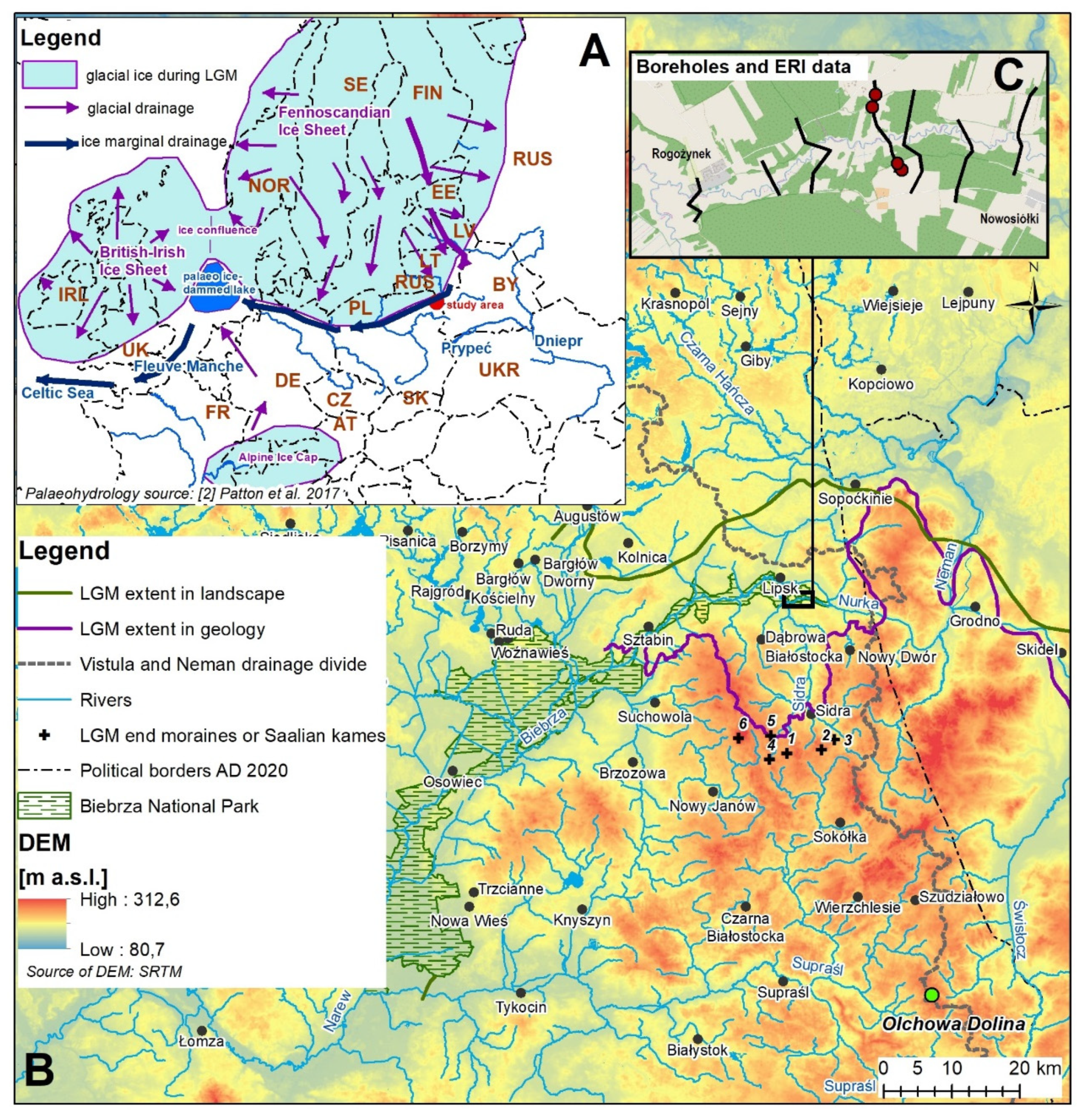
2. Study Area
3. Materials and Methods
4. Results
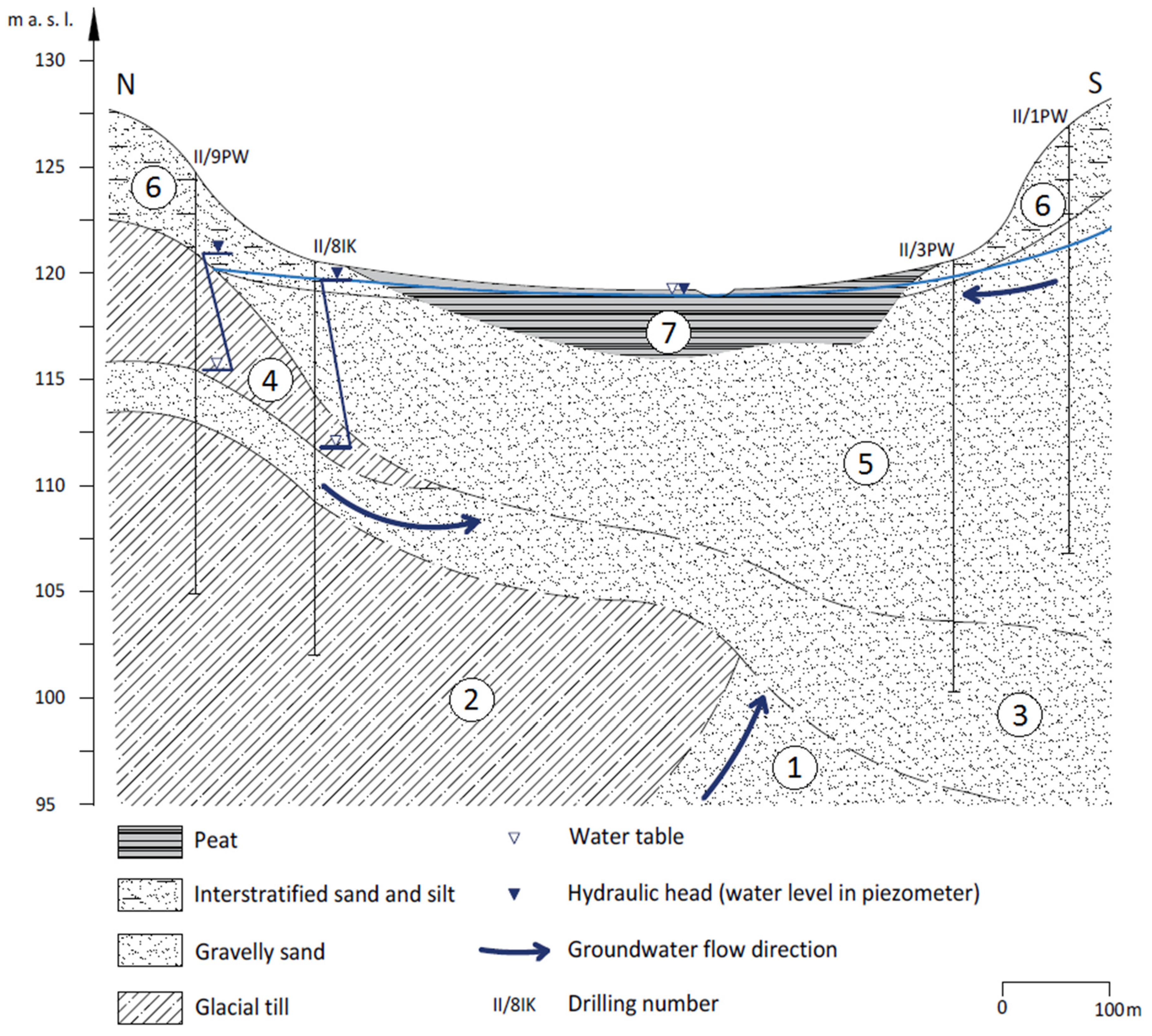
4.1. Local Geological Setting
4.2. Regional Geological Setting
5. Discussion and Insights
5.1. Extent of the Last Glacial Maximum in Northeastern Poland
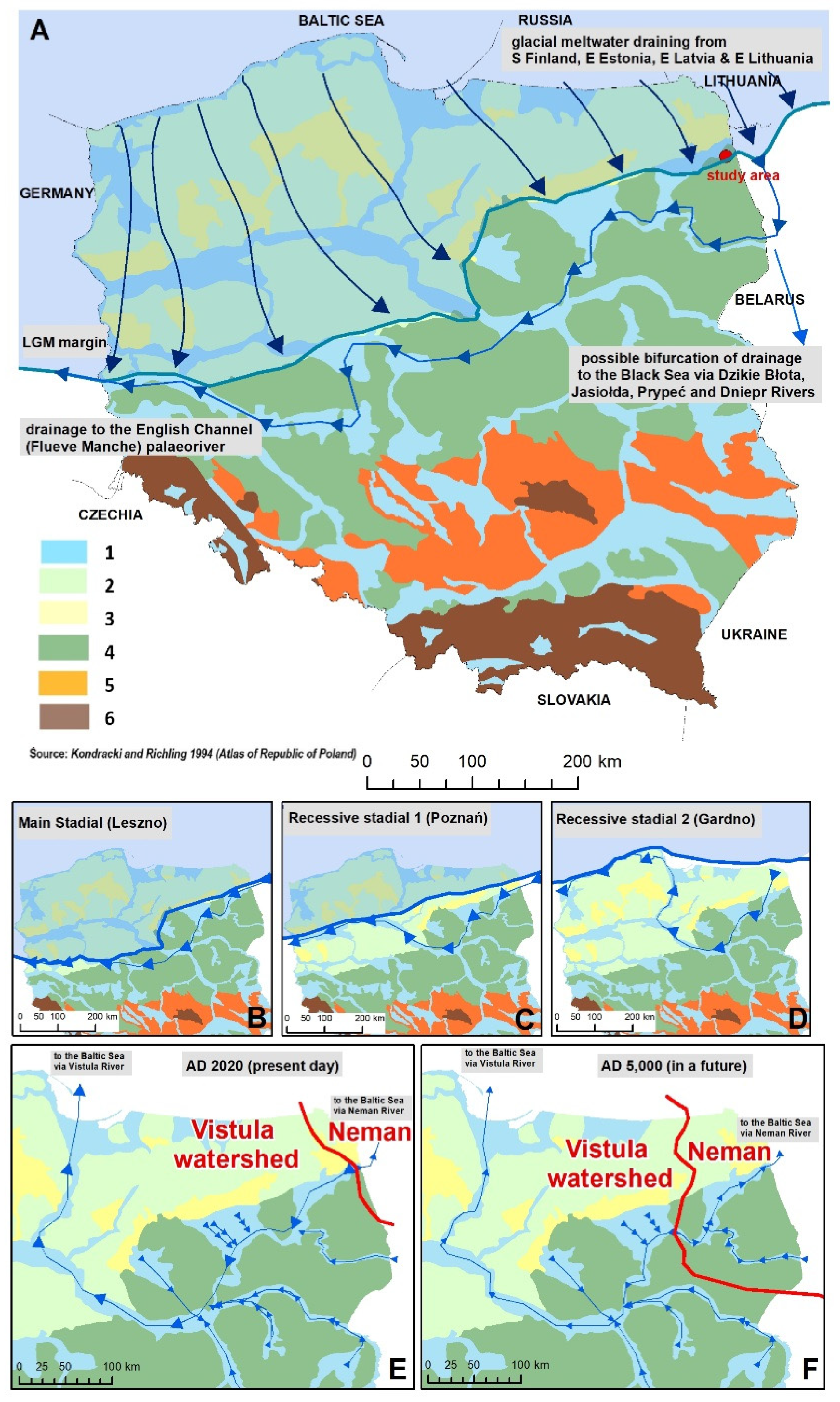
5.2. Post-Pleistocene Evolution of Regional Hydrology
5.3. Evolution of Hydrological System in the Holocene, Nowadays and in Future
Supplementary Materials
Author Contributions
Funding
Acknowledgments
Conflicts of Interest
References
- Stroeven, A.P.; Hättestrand, C.; Kleman, J.; Heyman, J.; Fabel, D.; Fredin, O.; Goodfellow, B.W.; Harbor, J.M.; Jansen, J.D.; Olsen, L.; et al. Deglaciation of Fennoscandia. Quat. Sci. Rev. 2016, 147, 91–121. [Google Scholar] [CrossRef] [Green Version]
- Patton, H.; Hubbard, A.; Andreassen, K.; Auriac, A.; Whitehouse, P.L.; Stroeven, A.P.; Shackleton, C.; Winsborrow, M.; Heyman, J.; Hall, A.M. Deglaciation of the Eurasian ice sheet complex. Quat. Sci. Rev. 2017, 169, 148–172. [Google Scholar] [CrossRef] [Green Version]
- Dyke, A.S.; Andrews, J.T.; Clark, P.U.; England, J.H.; Miller, G.H.; Shaw, J.; Veillette, J.J. The Laurentide and Innuitian ice sheets during the Last Glacial Maximum. Quat. Sci. Rev. 2002, 21, 9–31. [Google Scholar] [CrossRef]
- Marshall, S.J.; James, T.S.; Clarke, G.K.C. North American Ice Sheet reconstructions at the Last Glacial Maximum. Quat. Sci. Rev. 2002, 21, 175–192. [Google Scholar] [CrossRef]
- Pisarska-Jamroży, M. Factors controlling sedimentation in the Toruń-Eberswalde ice-marginal valley during the Pomeranian phase of the Weichselian glaciation: On overview. Geologos 2015, 21, 1–29. [Google Scholar] [CrossRef] [Green Version]
- Weckwerth, P.; Wysota, W.; Piotrowski, J.A.; Adamczyk, A.; Krawiec, A.; Dąbrowski, A. Late Weichselian glacier outburst floods in North-Eastern Poland: Landform evidence and palaeohydraulic significance. Earth-Sci. Rev. 2019, 194, 216–233. [Google Scholar] [CrossRef]
- Ulomov, V.I.; Akatova, K.N.; Medvedeva, N.S. Estimation of Seismic Hazard in the Kaliningrad Region. Izv. Phys. Solid Earth 2017, 44, 691–705. [Google Scholar] [CrossRef]
- Pisarska-Jamrozy, M.; Belzyt, S.; Borner, A.; Hoffmann, G.; Huneke, H.; Kenzler, M.; Obst, K.; Rother, H.; van Loon, A.J. Evidence from seismites for glacio-isostatically induced crustal faulting in front of an advancing land-ice mass (Rugen Island, SW Baltic Sea). Tectonophysics 2018, 745, 338–348. [Google Scholar] [CrossRef]
- Pisarska-Jamrozy, M.; Belzyt, S.; Bitinas, A.; Jusiene, A. Seismic shocks, periglacial conditions and glaciotectonics as causes of the deformation of a Pleistocene meandering river succession in central Lithuania. Baltica 2019, 32, 63–77. [Google Scholar]
- Steffen, H.; Steffen, R.; Tarasov, L. Modelling of glacially-induced stress changes in Latvia, Lithuania and the Kaliningrad District of Russia. Baltica 2019, 32, 78–90. [Google Scholar]
- Oświt, J. Structure, genesis and development of peatlands in the Biebrza Valley. Zeszyty Problemowe Postępów Nauk Rolniczych 1984, 372, 185–217. (In Polish) [Google Scholar]
- Pajnowska, H.; Poźniak, R. Hydrogeology of the Biebrza Valley and the surrounding areas. Zeszyty Problemowe Postępów Nauk Rolniczych 1984, 372, 63–74. (In Polish) [Google Scholar]
- Żurek, S. Relief, geologic structure and hydrography of the Biebrza Valley. Pol. Ecol. Stud. 1984, 10, 231–259. [Google Scholar]
- Krzywicki, T. Detailed Geological Map of Poland 1:50,000; Sheet 187 Lipsk; PGI: Warszawa, Poland, 2003. [Google Scholar]
- Majewska, A. Detailed Geological Map of Poland 1:50,000; Sheet 188 Rygałówka (Sopoćkinie); PGI: Warszawa, Poland, 2007. [Google Scholar]
- Marks, L.; Karabanov, A.K. Geological Map 1:250,000 of Polish—Belarusian Cross-Border Area Sokółka and Grodno Region; PGI: Warszawa, Poland, 2011. [Google Scholar]
- Kozłowski, I. Detailed Geological Map of Poland 1:50,000; Sheet 224 Suchowola; PGI: Warszawa, Poland, 2003. [Google Scholar]
- Wrotek, K. Detailed Geological Map of Poland 1:50,000; Sheet 225 Dąbrowa Białostocka; PGI: Warszawa, Poland, 2009. [Google Scholar]
- Krzywicki, T. The maximum ice sheet limit of the Vistulian Glaciation in northeastern Poland and neighbouring areas. Geol. Quart. 2002, 46, 165–188. [Google Scholar]
- Kondracki, J.; Richling, A. Regiony Ficzycznogeograficzne: Atlas Rzeczypospolitej Polskiej [Physico-Geographical Regions: Atlas of the Republic of Poland]; Map Sheet 53.3; GGK: Warsaw, Poland, 1994. [Google Scholar]
- Solon, J.; Borzyszkowski, J.; Bidłasik, M.; Richling, A.; Badora, K.; Balon, J.; Brzezińska-Wójcik, T.; Chabudziński, Ł.; Dobrowolski, R.; Grzegorczyk, I.; et al. Physico-geographical mesoregions of Poland: Verification and adjustment of boundaries on the basis of contemporary spatial data. Geogr. Pol. 2018, 91, 143–170. [Google Scholar] [CrossRef]
- Żarski, M.; Winter, H.; Kucharska, M. Palaeoenvironmental and climate changes recorded in the lacustrine sediments of the Eemian Interglacial (MIS 5e) in the Radom Plain (Central Poland). Quat. Int. 2018, 467, 147–160. [Google Scholar] [CrossRef]
- McDeid, S.M.; Green, D.I.S.; Crumpton, W.G. Morphology of Drained Upland Depressions on the Des Moines Lobe of Iowa. Wetlands 2019, 39, 587–600. [Google Scholar] [CrossRef]
- Margold, M.; Stokes, C.R.; Clark, C.D. Reconciling records of ice streaming and ice margin retreat to produce a palaeogeographic reconstruction of the deglaciation of the Laurentide Ice Sheet. Quat. Sci. Rev. 2018, 189, 1–30. [Google Scholar] [CrossRef]
- Evans, D.J.A.; Atkinson, N.; Philips, E. Glacial geomorphology of the Neutral Hills Uplands, southeast Alberta, Canada: The process-form imprints of dynamic ice streams and surging ice lobes. Geomorphology 2020, 350, 106960. [Google Scholar] [CrossRef]
- Davies, B.J.; Livingstone, S.J.; Roberts, D.H.; Evans, D.J.A.; Gheorghiu, D.M.; Cofaigh, C.Ó. Dynamic ice stream retreat in the central sector of the last British-Irish Ice Sheet. Quat. Sci. Rev. 2019, 225, 105989. [Google Scholar] [CrossRef]
- Wrotek, K. Objaśnienia do Szczegółowej Mapy Geologicznej Polski, Arkusz 225 Dąbrowa Białostocka; PIG: Warszawa, Poland, 2017. Available online: http://bazadata.pgi.gov.pl/data/smgp/arkusze_txt/smgp0225.pdf (accessed on 9 July 2020).
- Majewska, A. Objaśnienia do Szczegółowej Mapy Geologicznej Polski, Arkusz 226 Nowy Dwór; PIG: Warszawa, Poland, 2007. Available online: http://bazadata.pgi.gov.pl/data/smgp/arkusze_txt/smgp0226.pdf (accessed on 9 July 2020).
- Benn, D.I.; Evans, D.J.A. Glaciers and Glaciation; Arnold: London, UK, 1998. [Google Scholar]
- Gruszka, B.; Terpiłowski, S. Sedimentary Record of the Younger Saalian Ice Margin Stagnation in Eastern Poland. Geogr. Ann. Ser. A Phys. Geogr. 2015, 97, 279–298. [Google Scholar] [CrossRef]
- Evans, D.J.A.; Ewertowski, M.; Orton, C. Skaftafellsjokull, Iceland: Glacial geomorphology recording glacier recession since the Little Ice Age. J. Maps 2017, 13, 358–368. [Google Scholar] [CrossRef] [Green Version]
- Chandler, B.M.P.; Evans, D.J.A.; Chandler, S.J.P.; Ewertowski, M.W.; Lovell, H.; Roberts, D.H.; Schaefer, M.; Tomczyk, A.M. The glacial landsystem of Fjallsjökull, Iceland: Spatial and temporal evolution of process-form regimes at an active temperate glacier. Geomorphology 2020, 361, 107192. [Google Scholar] [CrossRef]
- Barrell, D.J.; Putnam, A.E.; Denton, G.H. Reconciling the onset of deglaciation in the Upper Rangitata valley, Southern Alps, New Zealand. Quat. Sci. Rev. 2019, 203, 141–150. [Google Scholar] [CrossRef]
- Davies, B.J.; Thorndycraft, V.R.; Fabel, D.; Martin, J.R.V. Asynchronous glacier dynamics during the Antarctic Cold Reversal in central Patagonia. Quat. Sci. Rev. 2018, 200, 287–312. [Google Scholar] [CrossRef]
- Evans, D.J.A.; Ewertowski, M.; Orton, C.; Graham, D.J. The Glacial Geomorphology of the Ice Cap Piedmont Lobe Landsystem of East Mýrdalsjökull, Iceland. Geosciences 2018, 8, 194. [Google Scholar] [CrossRef] [Green Version]
- Martin, J.R.V.; Davies, B.J.; Thorndycraft, V.R. Glacier dynamics during a phase of Late Quaternary warming in Patagonia reconstructed from sediment-landform associations. Geomorphology 2019, 337, 111–133. [Google Scholar] [CrossRef]
- Sen Singh, D.; Dubey, C.A.; Kumar, D.; Vishawakarma, B.; Singh, A.K.; Tripathi, A.; Gautam, P.K.; Bali, R.; Agarwal, K.K.; Sharma, R. Monsoon variability and major climatic events between 25 and 0.05 ka BP using sedimentary parameters in the Gangotri Glacier region, Garhwal Himalaya, India. Quat. Int. 2019, 507, 148–155. [Google Scholar] [CrossRef]
- Wysocka-Czubaszek, A.; Roj-Rojewski, S. Variability of Soil Properties in Eroded Agricultural Landscape. J. Ecol. Eng. 2020, 21, 72–80. [Google Scholar] [CrossRef]
- Włodarski, W.; Orłowska, A. Topography and melting dynamics of ice-cored ridges: Evidence from the geometry, kinematics and sedimentary evolution of collapse structures within kame deposits, eastern Poland. Boreas 2019, 48, 891–912. [Google Scholar] [CrossRef]
- Kupryjanowicz, M.; Drzymulska, D. Evolution of a small Eemian lake in a unique location on a kame hill: Haćki site, NE Poland. Quat. Int. 2015, 386, 203–207. [Google Scholar] [CrossRef]
- Terpiłowski, S. Genesis of transverse kame trains in eastern Poland. Sediment. Geol. 2007, 193, 59–69. [Google Scholar] [CrossRef]
- Godlewska, A.; Terpiłowski, S. Transverse, supraglacially derived crevasse infillings in a Pleistocene ice-sheet margin zone (eastern Poland): Genesis and sedimentary record. Geomorphology 2012, 161, 73–81. [Google Scholar] [CrossRef]
- Widera, M. Geomorphology, Sedimentology and Origin of the Glacigenic Złota Góra Hills near Konin (Central Poland). Geol. Q. 2011, 55, 235–252. [Google Scholar]
- Falkowska, E. Glacial Morphogenesis of Uplands of the Warta Glaciation in Poland as a Control on Heavy Metal Distribution in Deposits. Geol. Q. 2010, 53, 293–304. [Google Scholar]
- Morawski, W. Englacial kames near Jeziorany (Warmia-western Masurian lakeland, Poland): Morphology, internal structure and origin. Sediment. Geol. 2007, 193, 47–58. [Google Scholar] [CrossRef]
- Ber, A. O zasięgu zlodowacenia Wisły w Polsce północno-wschodniej na podstawie badań geomorfologicznych i termoluminescencyjnych (w odpowiedzi H. Banaszukowi). Pol. Geogr. Rev. 2002, 74, 243–248. [Google Scholar]
- Banaszuk, H. W odpowiedzi Andrzejowi Berowi. Pol. Geogr. Rev. 2002, 74, 255–264. [Google Scholar]
- Żurek, S. Uwagi na temat zasięgu zlodowacenia Wisły w Polsce północno-wschodniej w związku z artykułem H.Banaszuka. Pol. Geogr. Rev. 2002, 74, 265. [Google Scholar]
- Majewska, A. Detailed Geological Map of Poland 1:50,000; Sheet 226 Nowy Dwór; PGI: Warszawa, Poland, 2007. [Google Scholar]
- Woronko, B.; Rychel, J.; Karasiewicz, T.M.; Kupryjanowicz, M.; Adamczyk, A.; Fiłoc, M.; Marks, L.; Krzywicki, T.; Pochocka-Szwarc, K. Post-Saalian transformation of dry valleys in eastern Europe: An example from NE Poland. Quart. Int. 2018, 467, 161–177. [Google Scholar] [CrossRef]
- Pavlovskaya, I.E. Late Pleistocene evolution of Hydrographical Network Recorded at Geosites in the Middle Neman Area (Western Belarus). Pol. Geol. Inst. Spec. Pap. 2004, 13, 167–174. [Google Scholar]
- Gledko, J.A. Geomorfologiceskaya Karta 1:3 000 000 (Rel’ef); Atlas Geografija Belarusi 10 kl; RUP Belkartografija: Minsk, Belarus, 2016; p. 11. [Google Scholar]
- Lindner, L.; Sańko, A. Late Pleistocene evolution of the Niemen River valley near Grodno in Belarus. Przegląd Geol. 2008, 56, 73–80. [Google Scholar]
- Dylik, J. Thermokarst, a neglected phenomenon in studies of the Pleistocene. Ann. Geogr. 1964, 73, 513–523. [Google Scholar] [CrossRef]
- Edwards, M.; Grosse, G.; Jones, B.M.; McDowell, P. The evolution of a thermokarst-lake landscape: Late Quaternary permafrost degradation and stabilization in interior Alaska. Sediment. Geol. 2016, 340, 3–14. [Google Scholar] [CrossRef] [Green Version]
- Stephani, E.; Drage, J.; Miller, D.; Jones, B.M.; Kanevskiy, M. Taliks, cryopegs, and permafrost dynamics related to channel migration, Colville River Delta, Alaska. Permafr. Periglac. Process. 2020, 31, 239–254. [Google Scholar] [CrossRef]
- Dąbski, M. Should Glaciers Be Considered Permafrost? Geosciences 2019, 9, 517. [Google Scholar] [CrossRef] [Green Version]
- Kitover, D.C.; van Balen, R.T.; Vandenberghe, J.; Roche, D.M.; Renssen, H. LGM Permafrost Thickness and Extent in the Northern Hemisphere derived fromthe Earth System ModeliLOVECLIM. Permafr. Periglac. Process. 2016, 27, 31–42. [Google Scholar] [CrossRef]
- Saito, K.; Sueyoshi, T.; Marchenko, S.; Romanovsky, V.; Otto-Bliesner, B.; Walsh, J.; Bigelow, N.; Hendricks, A.; Yoshikawa, K. LGM permafrost distribution: How well can the latest PMIPmulti-model ensembles perform reconstruction? Clim. Past 2013, 9, 1697–1714. [Google Scholar] [CrossRef] [Green Version]
- Séjourné, A.; Costard, F.; Fedorov, A.; Gargani, J.; Skorve, J.; Massé, M.; Mège, D. Evolution of the banks of thermokarst lakes in Central Yakutia (Central Siberia) due to retrogressive thaw slump activity controlled by insolation. Geomorphology 2015, 241, 31–40. [Google Scholar] [CrossRef]
- Bagnold, R.A. An approach to the sediment transport problem from general physics. US Geol. Surv. Prof. Pap. 1966, 422, 1–37. [Google Scholar]
- Bull, W.B. Threshold of critical power in streams. Geol. Soc. Am. Bull. 1979, 90, 453–464. [Google Scholar] [CrossRef]
- Wierzbicki, G.; Ostrowski, P.; Mazgajski, M.; Bujakowski, F. Using VHR multispectral remote sensing and LIDAR data to determine the geomorphological effects of overbank flow on a floodplain (the Vistula River, Poland). Geomorphology 2013, 183, 73–81. [Google Scholar] [CrossRef]
- Dylikowa, A. Problematyka wydm śródlądowych w Polsce w świetle badań strukturalnych. Geogr. Stud. 1969, 75, 39–74. [Google Scholar]
- Marcinkowski, P.; Grabowski, P.C.; Okruszko, T. Controls on anastomosis in lowland river systems: Towards process-based solutions to habitat conservation. Sci. Total Environ. 2017, 609, 1544–1555. [Google Scholar] [CrossRef] [Green Version]
- Grygoruk, M.; Rannow, S. Mind the Gap! Lessons from science-based stakeholder dialogue in climate-adapted management of wetlands. J. Environ. Manag. 2017, 186, 108–119. [Google Scholar] [CrossRef]


© 2020 by the authors. Licensee MDPI, Basel, Switzerland. This article is an open access article distributed under the terms and conditions of the Creative Commons Attribution (CC BY) license (http://creativecommons.org/licenses/by/4.0/).
Share and Cite
Wierzbicki, G.; Grygoruk, M.; Grodzka-Łukaszewska, M.; Bartold, P.; Okruszko, T. Mire Development and Disappearance due to River Capture as Hydrogeological and Geomorphological Consequences of LGM Ice-Marginal Valley Evolution at the Vistula-Neman Watershed. Geosciences 2020, 10, 363. https://doi.org/10.3390/geosciences10090363
Wierzbicki G, Grygoruk M, Grodzka-Łukaszewska M, Bartold P, Okruszko T. Mire Development and Disappearance due to River Capture as Hydrogeological and Geomorphological Consequences of LGM Ice-Marginal Valley Evolution at the Vistula-Neman Watershed. Geosciences. 2020; 10(9):363. https://doi.org/10.3390/geosciences10090363
Chicago/Turabian StyleWierzbicki, Grzegorz, Mateusz Grygoruk, Maria Grodzka-Łukaszewska, Piotr Bartold, and Tomasz Okruszko. 2020. "Mire Development and Disappearance due to River Capture as Hydrogeological and Geomorphological Consequences of LGM Ice-Marginal Valley Evolution at the Vistula-Neman Watershed" Geosciences 10, no. 9: 363. https://doi.org/10.3390/geosciences10090363