Earthquake Early Warning Systems as an Asset Risk Management Tool


1
Instituto Superior Técnico, Universidade de Lisboa, Av. Rovisco Pais, 1047-001 Lisbon, Portugal
2
CERIS, Instituto Superior Técnico, Universidade de Lisboa, Av. Rovisco Pais, 1047-001 Lisbon, Portugal
*
Author to whom correspondence should be addressed.
CivilEng 2021, 2(1), 120-133; https://doi.org/10.3390/civileng2010007
Submission received: 25 October 2020
/
Revised: 14 January 2021
/
Accepted: 20 January 2021
/
Published: 2 February 2021
(This article belongs to the Special Issue Addressing Risk in Engineering Asset Management)
Abstract
:Losses due to strong seismic events can amount to millions or billions of US dollars and can affect regions for large periods of time, even severely undermining the economy. Earthquake early warning systems have proven to be helpful tools to mitigate the social and economic impact on communities and businesses. Recent case studies are briefly described, followed by examples of proactive measures for assets, infrastructure, citizens education and empowerment, complementary to earthquake early warning systems.
1. Introduction
During the last few decades, many efforts were made to create and develop efficient early warning systems for different hazards. This paper focuses on assessing the performance of earthquake early warning systems (EEWS) and their applicability as an asset risk management tool.
Earthquakes are the sudden release of energy due to rupture on faults and fractures. The stress released as energy during the rupture has been accumulated due to plate activity or volcanic activity. Earthquakes can have a wide range of direct and indirect impacts, including loss of life, damage to public and private properties and infrastructure as well as tax impacts arising from recovery and reconstruction expenditures and decreased tax revenues [1].
Earthquake casualties are, in general, the result of the total or partial collapse of buildings, and falling non-structural elements (e.g., roof tiles, chimneys, bricks, light fixtures and ceiling plaster) [2,3,4]. The higher tolls are usually concentrated in developing countries, where innovative seismic-resistant and engineering technologies are not applied [5].
Economic loss can also be assessed through the loss of value-owned business assets, items owned, created, or beneficial to businesses that include intangible assets, like intellectual property and other assets such as for instance infrastructure, buildings, facilities [6]. The concentration of assets in disaster-prone regions increases their exposure to hazards, leading to necessary actions to strengthen the physical and financial resilience of these regions to disasters; this has become a policy priority for individuals, companies, and countries [7].
Business continuity planning is key to protect assets and maintain the ability to supply goods and services to clients and/or supply chains, to preserve competitiveness and overall quality, and fulfill legal and contractual obligations [8]. Moreover, statistics suggest that 75% of businesses without a business continuity plan will fail within three years after a disaster.
In addition, long-term psychological and social effects on the population affected by the disastrous events that disrupt activities, such as relocation, homelessness, emotional traumas, and post-traumatic disorders [9] should also be considered.
Seismic events can trigger devastating so-called Na-tech events [10], defined as the release of hazardous material triggered by natural hazards or disasters (e.g., release of chemical and industrial products). The released materials can not only affect the population, but also the environment (e.g., atmosphere, soil, and water pollution) for a period that will depend on the released material’s chemical properties and characteristics [11].
In recent decades, two seismic events were among the costliest natural disasters: the 2008 Sichuan Earthquake in the People’s Republic of China (US$85 billion in damages and an estimated 84,000 fatalities) and the 2011 Great East Japan Earthquake (US$210 billion in overall losses and near 16,000 fatalities) [1].
To mitigate the consequences and reduce losses, early warning systems have been developed worldwide. These systems issue timely alerts to populations with information before the hazard occurs, allowing them to take protective measures [12]. Warnings for incoming S-waves can give people time to adopt the “Drop, Cover, Hold” safety protocol or for automated devices (e.g., chemical, and industrial factories) to prevent cascading events, like fire or toxic material spills [13].
This EWS concept can be applied not only to earthquakes, but also to floods, landslides, tsunamis, and volcano eruptions [14].
Some EEWS have been in operation for years, whilst others are still being tested [15]. EEWS are implemented in such countries as Mexico, Chile, Costa Rica, El Salvador, Nicaragua, United States (West Coast), Italy, Romania, Switzerland, Turkey, Israel, India, China, Japan, Taiwan, and South Korea [16].
Although it is not possible to assess the future benefits of EWSs, it is possible to assess physical benefits, both to infrastructures and human lives, through comparison with past events [17,18].
This paper presents the EEWS general structure, with a summary of the international experience and implementation challenges. The following is a summary of earthquakes’ worldwide impact and the estimated impacts of EEWSs, considering the past assessment of events located in high seismicity regions. Finally, proactive security measures are summarized for an adequate preparation towards seismic events in several situations, activities, and locations.
This paper shows that EEWSs are valuable tools to be included in the decision-making process, that seeks to balance cost and performance throughout the full lifecycle of physical assets.
2. Earthquake Early Warning Systems
2.1. Earthquake Early Warning System Concept
An EEWS is the combination of different elements, such as seismometers, sensors, communication appliances, computers, and alarm systems, able to detect and warm of the arrival of seismic waves. It serves to mitigate damages and losses [16,19], to be used primarily in moderate and high seismically active regions.
Nowadays, EEWSs are operational or are being tested to soon be fully operational all around the world: in Mexico, Japan, South Korea, Taiwan, Romania, Turkey, India, and the USA, EEWS have been active for many years, whilst in Chile, China, Costa Rica, El Salvador, Israel, Italy, Nicaragua, and Switzerland, EEWSs are being tested [15]. In Asia-Pacific countries, the growth of the construction sector, following the promotion of smart city projects, is expected to create an increasing demand for early warning systems, predominantly for earthquake hazard.
These early warning systems can be network-based, with sensors located in possible seismogenic source areas, to determine the earthquake’s location and magnitude, and to project a certain area’s ground motion using progressive real-time data collected or stand-alone systems that use the first P-waves motion to project the detection site’s ground motion [20].
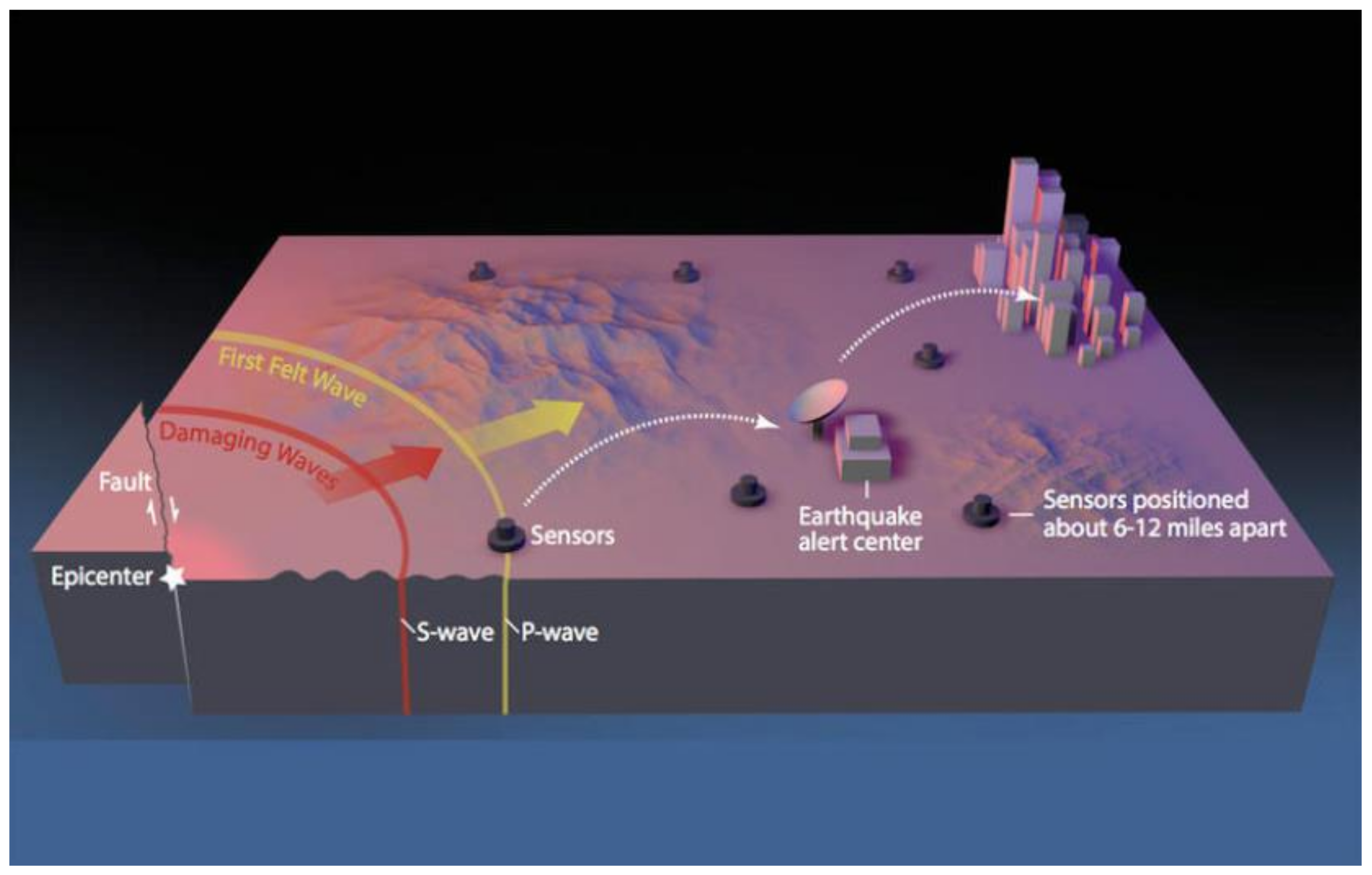
Figure 1 shows an example of the earthquake early warning system structure, MyShake EWS, developed by Berkeley University in collaboration with other US public institutions, national agencies, and universities [21]. The sensors were spatially organized to create a network covering Californian seismogenic sources. With recourse to algorithms and fixed threshold exceeded, the alert center will issue the warnings with basic information and lead time before the seismic waves’ arrival.
To create a worldwide sensors network, Berkeley University is testing, with the collaboration of Google [21], an application that can record, with end-user’s permission, a smartphone or tablet’s GPS position and movements (along the x, y, and z axes). The innovative system can distinguish seismic waves recorded from other types of movements or actions, like walking, own device vibration, and other anthropic sources of tremors [23].
During the last couple of decades, several algorithms were tested to identify the sources of seismic events, projected ground motion level and the lead time for S-waves arrival (e.g., EPIC, previously named ElarmS v3.0, or FinDer). These algorithms are continuously under test and improvement to enhance their performance. Regional EEWSs typically use a few seconds of P-wave data (0.5–4 s) from a small number of stations (usually two to six) to determine earthquake information [24].
Alerts issued for incoming seismic waves can be broadcast publicly, as in Mexico, Japan, South Korea, and Taiwan, where TV channels, radio stations, and mobile service companies warn the population nationwide. On the other hand, other EEWSs, such as those in India, Romania, Turkey, and the USA, broadcast alerts only to selected groups of users [15].
The applicability of these EEWSs can be limited: distance from the epicenter, hypocenter depth, and magnitude of the event can influence the alert time given to a population and to machines to act [25].
2.2. International Experience
One of the most well-known EEWSs worldwide is managed by the Japanese Meteorological Agency (JMA), that has been broadcasting warnings since 2007. The warning system issues the alarm to the public when the seismic intensity is equal to 5 or above (JMA scale, equivalent to VII–VIII on the Modified Mercalli intensity (MMI) scale), defining the origin time, the epicentral location, the magnitude, and the sub-Prefectural areas that will expect stronger seismic intensity [26]. The system will only issue an alert if the event is detected by more than one station. The lead time for seismic waves to reach the prefectures is not given within the alert information due to a wide time variability between neighboring areas [26]. The alert is broadcast through several television channels, radio stations, loudspeakers, and free text messages are sent by mobile phone companies [26].
Together with this early warning system, Japan has well-developed dissemination and communication strategies to educate the population on earthquakes and actions to be taken.
Another EEWS that has been working for more than a decade is the Mexican Seismic Alert System—SASMEX. The public warning system, operational since 1993, issues an alert when two or more seismic stations detect events with a magnitude higher than 5.5 on the MMI scale. The system counts on a network of 97 monitoring stations that cover the area between Morelia, Mexico City, Puebla, and the Mexican Pacific coast. Warnings are publicly broadcast through TV channels, radio stations, and loudspeakers, together with a dedicated radio channel, SASPER, used to alert authorities, universities, schools, emergency responders, and civil protection. This EEWS successfully alerted the Mexican population of the arrival of the strong-motion waves of the 8.2-magnitude Tehuantepec and the 7.1-magnitude Morelos earthquakes, both in 2017. The warning issued for the 8.2-magnitude Tehuantepec earthquake had a lead time of almost 2 min, while the warning issued for the 7.1-magnitude Morelos earthquake was only a few seconds earlier [27].
The Mexican government has sent educational brochures to 2 million households, providing information on actions to follow and behavior to avoid when a warning is issued. In addition, evacuation drills were organized in schools and in critical structures every month [28].
2.3. Challenges to the Implementation of Early Warning Systems
Large-magnitude earthquakes can affect huge areas; however, generally speaking, earthquake-induced damage is mostly concentrated at relatively smaller epicentral distances and close to the rupturing fault. Thus, the most critical objective for any EEWS is to provide an initial alert within a few seconds, so that alerts can be issued as close as possible to the epicenter [15].
Following this initial alert, there is time to provide better information or to alert a larger region regarding an upcoming larger event to take place in the tens of seconds that follow.
Allen and Melgar [15] compiled in Table 1 the maximum epicentral distance where the Modified Mercalli Intensity (MMI) V is expected to be felt and the S-wave arrival time at the greatest distance where MMI V is expected, for various earthquake magnitudes and approximate fault length. These arrivals values were computed without considering the stratigraphy or the depth.
At first look, EEWSs can be considered more important for areas in the immediate proximity to seismogenic sources (some kilometers away), but even faraway areas, where quakes will cause less damage, can benefit from these warnings as an opportunity to create a culture of prevention and awareness [29].
An important challenge to be faced by EEWS providers is the need to issue alerts with small lead times together with high reliability to reduce false alarm rates [30].
Knowledge of seismogenic sources and the implementation of a dense seismic network in the fault area are important measures to increase estimations’ reliability on earthquake locations and sizes within ~5 s of the event source [31].
In the future, EEWS algorithms may integrate new sources of ground motion observations and additional data that could reduce detection time and improve early estimation of magnitude and location. For example, to increase the number of strong-motion sensors in urban areas, and to improve the system’s reliability, low-cost sensors can be placed at schools, public institutions, and industrial facilities [32].
For example, on 11 March 2011, the EEWS managed by the Japan Meteorological Agency (JMA), issued accurate warnings to areas near the epicenter. These alerts were issued tens of seconds before the main earthquake hit an area [33]. Following this alert, four nuclear power stations located close to the epicenter of the Great East Japan earthquake shut down automatically and bullet trains were slowed down by their own automated warning system.
3. Overview on the Impact of Earthquakes Worldwide
3.1. Human Losses
Despite the development of new technologies in the area of seismic-resistant construction, the populational growth, the consequent expansion to urban areas, and the poor construction quality in seismic-prone areas contribute to the high number of earthquake-related casualties.
Although earthquakes and tsunamis are low-frequency hazards, worldwide they contributed to nearly 750,000 direct deaths, from 1994 to 2013 [34]. This number of fatalities overcomes that of other natural hazards for the same period.
Two examples of the deadliest seismic events of the modern era, during the last decades, are the 2008 Sichuan earthquake (China), and the 2011 Tohoku earthquake (Japan).
The 2008 8.0-magnitude Great Sichuan Earthquake can be considered one of the deadliest earthquakes of the last decades: 69,226 fatalities, and 374,643 injuries [35]. These high numbers are a result of how insufficiently prepared the communities were (the Sichuan area is mostly a rural area), the buildings’ weakly seismic resistance, the increasing number of residents in that area due to immigration, and the inability to provide adequate health assistance after the event [36]. This disaster led the Chinese Government to create and develop an Earthquake Early Warning System, to educate the population on earthquakes and on how to respond to early warnings, and to implement a disaster risk management program.
The 9.0-magnitude Tohoku Oki earthquake was the deadliest seismic event in Japan after the Great Kanto earthquake in 1923, causing more than 18,000 casualties [37]. Several reports were published throughout the years to explain this high number of casualties, despite the seismic-resistant building codes, the active earthquake early warning system and related tsunamis, the coastal barriers to mitigate tsunamis destruction, and the education and dissemination strategies and programmes for the population. These studies’ main findings concluded that the maximum magnitude expected was underestimated and that the EEWS had issued a delayed warning or did not issue any warning at all for certain areas, (e.g., Kanto prefecture). The seismic event was the result of several ruptures along the same seismogenic source fault that led to an increasing amplitude of seismic waves. In addition, the broadcast system (TV and radios) that was supposed to warn the population had a maximum of 4 min delay in some areas. The estimated height of the tsunami waves was also considered as one of the causes of the high toll [37].
3.2. Economic Impact
Earthquakes can have a wide range of impacts, with potentially long-lasting effects throughout generations to come. In addition to the direct physical and emotional impact on human lives, buildings, equipment, and infrastructures, earthquakes can have an indirect impact at different economical levels, such as the overall rise of poverty, interruption of business activities with related increase of unemployment, and loss of production [1,38].
For example, in the San Francisco Bay area, it was estimated that half of all small businesses were permanently shut down after the 1989 Loma Prieta earthquake [38]. Similarly, after the Northridge earthquake (1994) in California, only 275 out of 1100 businesses surveyed recovered from the overall damage. The impact of the loss of jobs, as a consequence of the earthquakes, significantly affected the local economy [38].
After the Kobe Earthquake (1995), direct property losses were estimated at around US$147 billion, and ~US$100 billion losses related to interruption of business activities. Due to the extended inactivity period after the earthquake, it was estimated that more than 1000 small- and medium-sized businesses closed permanently [38]. The 2008 Great Sichuan earthquake left more than 5 million people homeless and had a cost of close to US$29 billion on direct losses alone [39].
3.3. Impact on Industrial Facilities
In industrial facilities, it is common to associate earthquake damage with structural damage. However, the seismic vulnerability of equipment should consider both structural damage and subsequent loss of containment [17,40,41] as typical industrial accident scenarios (e.g., explosion, fire, toxic dispersion) depend significantly on the amount of dangerous substances released. Krausmann et al. [17] classified storage tanks’ susceptibility to earthquake-induced damage as impressive as these tanks are commonly used to store flammable liquids. Thus, loss of containment can lead to a major accident, as there is a high ignition probability after the release of a flammable substance during an earthquake.
In chemical facilities, natural hazards and disasters can trigger multiple and simultaneous failures with often severe off-site consequences [17]. Below are a few examples:
- (i)
- During the 7.4-magnitude Kocaeli earthquake, in 1999, 24 industrial facilities (e.g., automotive, chemicals and petrochemicals, liquid gasses, refineries), located in the same area, were affected by both structural and non-structural damages that impacted directly on the regional economy, as they represented 40% of the entire Turkish heavy industry [42].
- (ii)
- After the 7.9-magnitude Wenchuan earthquake (2008) in China, the population and environment were affected by the release of toxic, explosive, and flammable materials from damaged storage located in a nearby strong industrialized area [15].
- (iii)
- The 9.0-magnitude Tōhoku earthquake (2011) in Japan led to the shutdown of six of the nine oil refineries: two of them caught fire and, in another refinery, an explosion caused by a LPG (liquefied petroleum gas) leakage spread fire to 14 other tanks in the vicinity. This explosion damaged surrounding residential buildings, vehicles, and more [43]. Additionally, the damages at the oil refineries were identified as the primary source for the fuel shortfall right after the disaster, which impacted not only people’s lives but also hindered the post-disaster recovery response to the affected areas [44]. Overall, 30% of Japan’s refining capacity was shut down for a week. In addition, 25% of Japan’s ethylene production capacity was interrupted due to the earthquake and took several months to be resumed [45,46]. Furthermore, the resuming of industrial production was hindered by several aftershocks, tsunami alerts, lack of utilities or raw material, and infrastructural damage. The overall losses due to the earthquake were estimated at around 34% in production capacity plus 6% losses caused by the tsunami [47]. After the event, only a few companies shared publicly the information related to their economic losses due to the earthquake and/or tsunami. JX Holdings, Inc. (petroleum and metals production), Cosmo Oil (petrochemical company), Sakai Chemical (chemical industry products), and Sumitomo Metals (metals manufacturer) reported extraordinary losses related to structural damages, suspension of production, and restoration costs [48,49,50].
3.4. Psychological and Social Impact
Earthquakes’ impacts cannot be exclusively assessed at the physical level, as Post-Traumatic Stress Disorder, depression, anxiety, stigma, psychological distress, changes in normal behavior, and food and sleep disorders can affect survivors and emergency responders at different levels.
An important study conducted by Harada et al. (2015) [9] on the population affected by the 2011 Tohoku earthquake assessed the impacts of the combination of earthquakes, tsunami, and the consequent nuclear accidents of Fukushima.
In relation to the nuclear accidents, people living in the Fukushima area were not only affected by mental health disorders, due to the traumatic experience, to uncertainties caused by the evacuation and resettlement, and to the fear of developing cancer, but were also victims of stigmatization and discrimination because of their exposure to nuclear radiation.
Civil servants and workers at the nuclear Fukushima plant were also subject to public discrimination by stakeholders for their mismanagement following the accident.
The study identified, as previous similar trends, that the populational groups most vulnerable to these disasters, or combination of earthquakes and other cascading events, were children, evacuated and resettled populations, relatives of deceased casualties, and individuals with preexisting physical/mental health illnesses.
Considering these results, it is necessary to consider, in addition to other post-disaster strategies, the psychological and social assistance to survivors, emergency responders, post-event cleaning workers, and risk management workers.
4. Estimated Impact of Earthquake Early Warning Systems (EEWSs)
EEWSs have proven their effectiveness in reducing economic losses, damages, and casualties.
Although is not always possible to assess and precisely quantify the benefits of EEWSs, it is possible to assess the potential and physical benefits of EEWSs, to both infrastructures and human lives, through comparison with past events and corresponding losses [18].
Buildings or infrastructures built prior to recent seismic-resistant codes or built with poor or weak materials could not benefit directly from early warning alerts.
4.1. United States of America
In California, during the Loma Prieta earthquake (San Francisco) and the 6.7-magnitude Northridge earthquake (Los Angeles), ~50% of injuries were caused by non-structural elements, such as ceilings tiles, furniture, heavy objects, more than by structural elements. These numbers show that if they had received an alert a few seconds before, people may have been able to act and protect themselves [51].
The monetary losses due to injuries, most of which related to non-structural elements [52], were calculated in US$1.8 to 2.9 billion (value of 2005 US Dollars). Thus, an EEWS can not only prevent injuries but it can also be translated into significant financial savings.
FEMA (Federal Emergency Management Agency) published the following comparison costs:
- (i)
- maintaining ShakeAlert for 1-year of operation—US$16 M;
- (ii)
- 0.25% of damages caused by fire as a consequence of gas ignition during the Hayward earthquake [53]—US$31 M;
- (iii)
- 1% of injuries caused by the Northridge earthquake [50]—US$20 M;
- (iv)
- cost to replace a train-car of 10 trail cars [51]—US$33 M.
Maintaining an EEWS is a sizeable investment, when compared with the cost of losses of not having one, it is a system clearly worth investing in [51].
4.2. Turkey
In 1999, the 7.0-magnitude Kocaeli earthquake caused 17,480 fatalities and injured more than 40,000 people. The earthquake hit in the early morning, and it was estimated that 76% of people died as they were unable to exit buildings, most of them remained in bed. 61% of fatalities were caused by structural elements, while non-structural elements, such as falling objects that hit, cut, and struck people caused 69% of non-fatal injuries [54].
An EEWS must alert citizens to protect themselves, but also improve their basic knowledge of earthquake protection measures.
4.3. China
In 2008, the 7.9-magnitude Wenchuan earthquake that hit Sichuan Province (China) is known to have been one of the most disastrous events of the last decades, with almost 70,000 casualties and 370,000 injured [35].
4.4. Japan
The 9.0-magnitude Tohoku-Oki earthquake of 2011, and consequent tsunami, caused more than 18,000 casualties. The EEWS alerted several million citizens in the epicenter’ area with a lead time of 15–20 s before the most severe ground motion occurred [37]. This time enabled ~90% of these citizens to implement the drop-cover-hold protocol or take other lifesaving measures.
This high percentage was due to Japanese society’s long experience with earthquakes, awareness, and education on how to behave and which actions to take in different situations: indoor and outdoor, in public and private buildings. These were also one of the reasons that led to upgrading the seismic monitoring network (earthquakes and tsunamis) with an advanced system connected to schools [37].
Four nuclear power stations and nuclear reactors, located close to the same event epicenter, were shut down safely and bullet trains were slowed down triggering the emergency brakes.
Fujinawa and Noda [37] used the Tohoku-Oki earthquake of 2011 as a reference for a simulation, where the lead times for the same earthquake varied. The following hypotheses were adopted: (i) workers can save their lives with a lead time of 10 s, (ii) students can take appropriate measures with a lead time of 5 s, and (iii) people can react well with a lead time of only 1 s.
Table 2 shows the simulation’s main results. A significant decrease in the number of deaths and an increase in the number of no injuries can be correlated with an increase in the lead time.
4.5. South Korea
In South Korea, the US$7 billion Honam high-speed railway project, 185 km long, began operation in April 2015. This high-speed rail service crosses roadbeds, bridges, and tunnels.
The rail infrastructure has sensors for real-time earthquake detection and structural monitoring, and it issues warnings in case of exceedance of predefined thresholds, offers interactive surveillance, provides data for structural integrity assessment and notifications for safe train operations as a way to improve safe trains operation [59].
5. Proactive Measures
Several public authorities and institutions issued guidelines to address different scenarios and locations when an earthquake occurs. If these safety measures can be coupled with an early warning received through traditional channels or recent mobile applications, the population will be better prepared.
5.1. Measures for Public Infrastructure
In addition to educating the population, Allen and Strauss [51] summarized a set of actions that can be applied to public infrastructures using an EEWS alert:
- (i)
- Hospitals: safely stopping surgeries, disconnecting ventilators to prevent fatal errors [60], opening automated doors, closing curtains to mitigate falling glass, securing radioactive sources and radiography equipment.
- (ii)
- Schools: alerts are issued by loudspeakers and TVs [61].
- (iii)
- Elevators: these should be equipped with earthquake detectors enabling them to return to the ground floor safely [62].
- (iv)
- Means of transport (like trains): have systems that can slow down the wagons before the strong motion waves hit in the area, causing train wrecks and casualties.
- (v)
- Private factories: have systems connected to the EEWS so production can be safely shut down to reduce secondary hazards (fires, gas intoxication, chemicals spills, etc.).
5.2. Measures for Citizens’ Education and Empowerment
The dissemination of information and safety measures to face earthquakes is an efficient strategy to mitigate human losses and prepare the population psychologically [63,64].
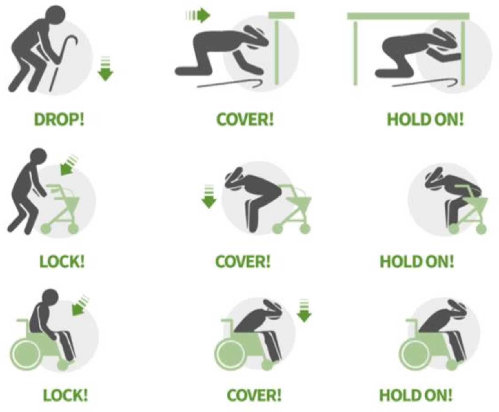
Worldwide, main actions to be taken during earthquakes are the well-known “Drop, Cover, Hold”, that can be applied to different scenarios, e.g., home, workplace, and schools. In some cases, people cannot physically reach tables or structures to be safe; below, Figure 2 shows some examples of how people with mobility limitations can act.
Other standard safety measures are: to stay away from windows, furniture, heavy objects located on upper shelves or hanging from the ceiling, electric equipment and glass doors; to avoid elevators and use the stairs only when the situation and their condition allows it; to turn off electricity and gas if and when possible to avoid explosions or fires; to avoid trees, streetlights, and electric poles; to avoid areas near rivers and sea/ocean due to the risk of a tsunami.
If possible, households can prepare different plans for seismic events, which envisage not only a safety kit to survive some days after the event without external help but also predetermine safe strategic meeting points where to regroup.
In addition to the mere dissemination of safety measures, educating the population on what to expect during earthquakes or after receiving an EEWS warning can help people act in a more rational way [66].
5.3. Measures for Seismic-Resistant Buildings
When it comes to seismic-resistant construction and renovations, Japan is one of the leading countries in seismic-resistant technologies. The three main technologies used in buildings nowadays for areas prone to seismic events are:
- (i)
- “quake resistance”, which means that a building is constructed strong enough to withstand vibrations.
- (ii)
- “vibration-damping”, which means that damping elements to absorb the vibrations are added to the building’s structure.
- (iii)
- “seismic isolation”, which introduces elements to isolate the building from its foundation to prevent vibrations from being transmitted directly to the building.
These technologies enable improving buildings’ resistance to seismic waves and reducing structural damages that can severely affect their practicability. In addition, materials used for this technological solution must be guaranteed to respect the updated construction codes for seismic-prone areas.
5.4. Measures for Assets
The US agency for emergency management, FEMA, produced, and published guidelines to help businesses be organized and prepared in case of earthquakes. These strategies are meant to safeguard not only the workforce and the facilities, but also the continuity of activities after seismic events. In brief, the following steps are recommended for an earthquake-resistant business [67]:
- (i)
- Identify potential hazards that may interrupt the business operations.
- (ii)
- Create a disaster plan to ensure business continuity, to greatly reduce the risks and losses, and guide decisions.
- (iii)
- Prepare the provision of independent post-disaster supplies, given the prioritization of hospitals and schools by first responders.
- (iv)
- Identify and fix the building’s vulnerabilities, e.g., structural elements, non-structural elements, emergency exits, furniture layout.
These measures will not only protect employees, customers, and public service’ workers, but will also allow businesses to have shorter recovery periods or to continue their activities.
6. Discussion
Earthquakes have been shown to cause a high number of casualties and destruction in a short amount of time. Their consequences cannot always be fully assessed due to the additional psychological and social impact that can affect the population.
High death tolls can follow as consequences of total or partial building collapse, non-structural elements not being secured, non-compliance with actual seismic-resistant layout, late or disorganized emergency response, lack of education on safety measures, or lack of dissemination of information by authorities, institutions, and the scientific world.
Earthquakes Early Warning Systems cannot operate in isolation but are certainly a valid solution to mitigate losses if combined with education and preparedness actions, such as updated construction codes, risk management tools, emergency plans, economic resilience plans for private businesses and public institutions, and dissemination, education, and empowerment of the population.
If these elements are not all efficiently working together, the creation of an Early Warning System will only be a palliative measure and will marginally contribute to the mitigation of losses.
A theme that must be discussed further is the risk management of assets, which comprehend not only tangible or intangible assets, as defined previously in the introduction paragraph.
The prevention and mitigation of losses should consider the assessment of how to protect assets in order to maintain public and private services operational, to ensure production continuity, and to prevent money stagnation and unemployment. This way, risk management of disastrous events should focus on the losses as a result of an event and on the future, considering long-term disaster impacts.
In addition, it should also be underlined that, without strong collaboration between the scientific community, national and regional authorities, policymakers, emergency management and security agencies, and citizens, prevention and mitigation measures cannot succeed.
7. Final Remarks
Seismic events are disastrous events that cannot be predicted in time. Considering past events and the experience gained, EEWSs have proven to be a fundamental tool to reduce human losses and mitigate economic consequences.
The worldwide population is growing and concentrating in urban areas, most of them located in high seismic-prone regions, thus increasing the need to deploy early warning systems.
Potential economic losses must be considered in the long term, as experience has shown that an area or country’s economic recovery can take years. The lack of risk assessment plans and natural hazard-related insurance for disasters at government, business, factory, industry, or personal level, may have long-term consequences, such as the impossibility to recover the business, which will consequently raise unemployment in the affected area, stagnate cash flow and risk a stagnant market.
Education, dissemination, raising awareness to natural hazards and how to act to protect ourselves and others is mandatory; these will continue to be key elements in making sure citizens are ready, thus reducing injuries and fatalities.
The resilience of communities and businesses can be improved with EEWS, which may seem expensive at first but are a clear payoff it the long run.
Author Contributions
Conceptualization, R.C.G. and L.B.; methodology, R.C.G. and L.B.; validation, R.C.G. and L.B.; formal analysis, R.C.G. and L.B.; investigation, L.B.; data curation, R.C.G. and L.B.; writing—original draft preparation, R.C.G. and L.B.; writing—review and editing, R.C.G. and L.B.; visualization, R.C.G. and L.B.; supervision, R.C.G. and L.B.; project administration, R.C.G. and L.B. All authors have read and agreed to the published version of the manuscript.
Funding
This research is co-financed by the Interreg Atlantic Area Programme through the European Regional Development Fund.
Institutional Review Board Statement
Not applicable.
Informed Consent Statement
Not applicable.
Conflicts of Interest
The authors declare no conflict of interest.
References
- OECD. Disaster Risk Financing: A Global Survey of Practices and Challenges; OECD Publishing: Paris, France, 2015. [Google Scholar]
- Abeling, S.; Horspool, N.; Johnston, D.; Dizhur, D.; Wilson, N.; Clement, C.; Ingham, J. Patterns of earthquake-related mortality at a whole-country level: New Zealand, 1840–2017. Earthq. Spectra 2020, 36, 138–163. [Google Scholar] [CrossRef]
- Horspool, N.; Elwood, K.; Johnston, D.; Deely, J.; Ardagh, M. Factors influencing casualty risk in the 14th November 2016 MW7. 8 Kaikōura, New Zealand earthquake. Int. J. Disaster Risk Reduct. 2020, 51, 101917. [Google Scholar] [CrossRef]
- Johnston, D.; Standring, S.; Ronan, K.; Lindell, M.; Wilson, T.; Cousins, J.; Kirsch, T. The 2010/2011 Canterbury earthquakes: Context and cause of injury. Nat. Hazards 2014, 73, 627–637. [Google Scholar] [CrossRef]
- Kenny, C. Why Do People Die in Earthquakes? The Costs, Benefits and Institutions of Disaster Risk Reduction in Developing Countries. In Policy Research Working Paper; World Bank: Washington, DC, USA, 2009. [Google Scholar]
- Invest Northern Ireland. Business Assets–Different Types of Business Assets. Available online: https://www.nibusinessinfo.co.uk/content/different-types-business-assets (accessed on 16 October 2020).
- Munich Re. Loss Events Worldwide 2014: 10 Costliest Events (Ordered by Overall Losses). 2015. Available online: http://www.neighborhoodrisk.org/uploads/1/4/3/7/14377764/2___10-costliest-events-ordered-by-overall-losses.pdf (accessed on 25 January 2021).
- FEMA. Earthquake Country Alliance and FLASH. QuakeSmart Ready Business Toolkit. 2020. Available online: https://www.ready.gov/sites/default/files/2020-04/ready-buisiness_quakesmart_toolkit.pdf (accessed on 16 October 2020).
- Harada, N.; Shigemura, J.; Tanichi, M.; Kawaida, K.; Takahashi, S.; Yasukata, F. Mental health and psychological impacts from the 2011 Great East Japan Earthquake Disaster: A systematic literature review. Disaster Mil. Med. 2015, 1, 17. [Google Scholar] [CrossRef] [Green Version]
- Antonioni, G.; Bonvicini, S.; Spadoni, G.; Cozzani, V. Development of a framework for the risk assessment of Natech accidental events. Reliab. Eng. Sys. Saf. 2009, 94, 1442–1450. [Google Scholar] [CrossRef]
- Krausmann, E.; Cruz, A.; Affeltranger, B. The impact of the 12 May 2008 Wenchuan earthquake on industrial facilities. J. Loss Prev. Process Ind. 2010, 23, 242–248. [Google Scholar] [CrossRef]
- Minghui, L. China’s National Early Warning Releasing System and GMAS-A. In CAP Implementation Workshop in Mexico City, Mexico; Global Disaster Preparedness Center (GDPC): Washington, DC, USA, 2019. [Google Scholar]
- Marino, A.; Ciucci, M. Smart approach to integrated natural risks management for industry 4.0. In Smart Structures and NDE for Energy Systems and Industry 4.0 (Proc. SPIE 10973); SPIE (International Society for Optics and Photonics): Bellingham, WA, USA, 2019; p. 1097306. [Google Scholar]
- UNISDR. Early Warning–From Concept to Action. In Proceedings of the Conclusions of the Third International Conference on Early Warning (EWC III), Bonn, Germany, 27–29 March 2006. [Google Scholar]
- Allen, R.M.; Melgar, D. Earthquake Early Warning: Advances, Scientific Challenges, and Societal Needs. 2019. Available online: https://preparecenter.org/resource/early-warning-systems/ (accessed on 16 October 2020).
- UNEP. Early Warning Systems: A State-of-the-Art Analysis and Future Directions Nairobi: Division of Early Warning and Assessment (DEWA); United Nations Environment Programme (UNEP): Nairobi, Kenya, 2012. [Google Scholar]
- Krausmann, E.; Renni, E.; Campedel, M.; Cozzani, V. Industrial accidents triggered by earthquakes, floods and lightning: Lessons learned from a database analysis. Nat. Hazards 2011, 59, 285–300. [Google Scholar] [CrossRef]
- Minson, S.E.; Baltay, A.S.; Cochran, E.; Hanks, T.C.; Page, M.T.; McBride, S.K.; Milner, K.R.; Meier, M.-A. The Limits of Earthquake Early Warning Accuracy and Best Alerting Strategy. Sci. Rep. 2019, 9, 1–13. [Google Scholar] [CrossRef]
- Transparency Market Research. Earthquake Early Warning System Market–Global Industry Analysis, Size, Share, Growth, Trends, and Forecast 2019–2027. 2020. Available online: https://www.transparencymarketresearch.com/earthquake-early-warning-system-market.html (accessed on 16 October 2020).
- Wang, Y.; Li, S.; Song, J. Threshold-based evolutionary magnitude estimation for an earthquake early warning system in the Sichuan–Yunnan region, China. Sci. Rep. 2020, 10, 1–12. [Google Scholar] [CrossRef] [PubMed]
- Stogaitis, M.; Barski, A.; Spooner, B.; Wimpey, G.; Robertson, P.; Kong, Q.; Allen, R.; Bosch, R.; Malkos, S.; Jiang, S.; et al. Earthquakes at Google. In Proceedings of the AGU Fall Meeting 2020 (online), 1–17 December 2020; Available online: https://www.agu.org/fall-meeting (accessed on 2 February 2021).
- Burkett, E.; Given, D.D.; Goertzen, J. ShakeAlert—An Earthquake Early Warning System for the United States West Coast; US Geological Survey: Reston, VA, USA, 2014.
- Marr, B. Google Builds Largest Earthquake Detection System with Your Phone. 2020. Available online: https://www.forbes.com/sites/bernardmarr/2020/09/25/google-builds-largest-earthquake-detection-system-with-your-phone/?fbclid=IwAR1eUcsWL16YvfX9avY65O1wHbbcw4d9IdE4iwaWUTcuAuF5lniagsBQQxI#5f47169d515a (accessed on 16 October 2020).
- Allen, R.M. The Potential for Earthquake Early Warning in Southern California. Science 2003, 300, 786–789. [Google Scholar] [CrossRef] [PubMed] [Green Version]
- Wald, L.A. Earthquake Information Products and Tools from the Advanced National Seismic System (ANSS); US Geological Survey: Reston, VA, USA, 2020; p. 2.
- Kamigaichi, O.; Saito, M.; Doi, K.; Matsumori, T.; Tsukada, S.; Takeda, K.; Shimoyama, T.; Nakamura, K.; Kiyomoto, M.; Watanabe, Y. Earthquake Early Warning in Japan: Warning the General Public and Future Prospects. Seism. Res. Lett. 2009, 80, 717–726. [Google Scholar] [CrossRef]
- Suárez, G.; Espinosa-Aranda, J.M.; Cuéllar, A.; Ibarrola, G.; García, A.; Zavala, M.; Maldonado, S.; Islas, R. A Dedicated Seismic Early Warning Network: The Mexican Seismic Alert System (SASMEX). Seism. Res. Lett. 2018, 89, 382–391. [Google Scholar] [CrossRef]
- Espinosa-Aranda, J.M.; Jimenez, M.A.; Ibarrola, G.; Alcantar, E.; Aguilar, A.; Inostroza, M.; Maldonado, S. Results of the Mexico City early warning system. In Proceedings of the Eleventh Worm Conference on Earthquake Engineering, Acapulco, Mexico, 23–28 June 1996. [Google Scholar]
- Allen, R.M.; Cochran, E.; Huggins, T.J.; Miles, S.; Otegui, D. Lessons from Mexico’s Earthquake Early Warning System. Eos Trans. 2018, 99. [Google Scholar] [CrossRef]
- Rogers, D.P.; Tsirkunov, V. Costs and Benefits of Early Warning Systems: Global Assessment Report on Disaster Risk Reduction; ISDR: Geneva, Switzerland; World Bank: Washington, DC, USA, 2010; p. 17. [Google Scholar]
- Satriano, C.; Elia, L.; Martino, C.; Lancieri, M.; Zollo, A.; Iannaccone, G. PRESTo, the earthquake early warning system for Southern Italy: Concepts, capabilities and future perspectives. Soil Dyn. Earthq. Eng. 2011, 31, 137–153. [Google Scholar] [CrossRef] [Green Version]
- ShakeAlert–Infrastructure. Available online: https://www.shakealert.org/eew-research/caltech/infrastructure/ (accessed on 16 October 2020).
- Cyranoski, D. Japan faces up to failure of its earthquake preparations. Nat. Cell Biol. 2011, 471, 556–557. [Google Scholar] [CrossRef] [Green Version]
- Wallemacq, P.; Guha-Sapir, D.; McClean, D. The Human Cost of Natural Disasters—A Global Perspective; Centre for Research on the Epidemiology of Disaster (CRED): Brussels, Belgium, 2015. [Google Scholar]
- Yu, J.; Yong, P.; Read, S.; Brabhaharan, P.; Foon, M. The Ms 8.0 Wenchuan earthquake of 12 May 2008 reconnaissance report. Bull. N. Z. Soc. Earthq. Eng. 2010, 43, 41–83. [Google Scholar] [CrossRef]
- Chan, E.Y.Y.; Lee, P.P.Y.; Ching, K.K.C. A Public Health Evaluation of 2008 Sichuan Earthquake in China; CCOUC (Collaborating Centre for Oxford University and CUHK for Disaster and Medical Humanitarian Response): Hong Kong, China, 2016. [Google Scholar]
- Fujinawa, Y.; Noda, Y. Japan’s earthquake early warning system on 11 March 2011: Performance, shortcomings, and changes. Earthq. Spectra 2013, 29, 341–368. [Google Scholar] [CrossRef]
- EPICC. Earthquake Planning for Business: A Guide for Businesses in British Columbia Emergency 427 Preparedness for Industry & Commerce Council July 2003; EPICC: Vancouver, BC, Canada, 2003. [Google Scholar]
- Kalantari, A. Seismic Risk of Structures and the Economic Issues of Earthquakes; INTECH Open Access Publisher: London, UK, 2012. [Google Scholar]
- Salzano, E.; Agreda, A.G.; Di Carluccio, A.; Fabbrocino, G. Risk assessment and early warning systems for industrial facilities in seismic zones. Reliab. Eng. Syst. Saf. 2009, 94, 1577–1584. [Google Scholar] [CrossRef]
- Young, S.; Balluz, L.; Malilay, J. Natural and technologic hazardous material releases during and after natural disasters: A review. Sci. Total Environ. 2004, 322, 3–20. [Google Scholar]
- Sezen, H.; Whittaker, A.S. Seismic Performance of Industrial Facilities Affected by the 1999 Turkey Earthquake. J. Perform. Constr. Facil. 2006, 20, 28–36. [Google Scholar] [CrossRef]
- Toyama, M.; Sagara, J.; Ishiwatari, M. Protecting Significant and Sensitive Facilities; World Bank: Washington, DC, USA, 2012. [Google Scholar]
- Ranghieri, F.; Ishiwatari, M. Learning from Megadisasters: Lessons from the Great East Japan Earthquake; World Bank: Washington, DC, USA, 2014. [Google Scholar]
- IEEJ. Eastern Japan Paralysed by Unprecedented Earthquake. Available online: https://www.siew.gov.sg/newsroom/articles/detail/2011/03/28/eastern-japan-paralysed-by-unprecedented-earthquake (accessed on 25 October 2020).
- Krausmann, E.; Cruz, A.M. Impact of the 11 March 2011, Great East Japan earthquake and tsunami on the chemical industry. Nat. Hazards 2013, 67, 811–828. [Google Scholar] [CrossRef]
- Tatano, H.; Kajitani, Y. Production capacity losses due to the 311 disaster—Facility damage and lifeline disruption impacts. In Proceedings of the International Disaster and Risk Conference, Davos, Switzerland, 26–30 August 2012. [Google Scholar]
- Cosmo Oil. Overview of Business Results of Fiscal Year Ending March 2012. 8 May 2012. Available online: https://ceh.cosmo-oil.co.jp/eng/ir/financial/result/2012/pdf/12e_4q_all.pdf (accessed on 25 January 2021).
- Sakai Chemical Industry. The Impact of the Tohoku District-Off the Pacific Ocean Earthquake (No. 4). 26 April 2011. Available online: http://www.sakai-chem.co.jp/en/pdf/pr110426.pdf (accessed on 25 January 2021).
- Sumitomo Metal Industry. Sumitomo Metals Announces Estimated Loss Caused by East Japan Earthquake. 14 April 2011. Available online: https://www.nipponsteel.com/en/news/old_smi/2011/pdf/110414-01_e.pdf (accessed on 25 January 2021).
- Strauss, J.A.; Allen, R.M. Benefits and Costs of Earthquake Early Warning. Seism. Res. Lett. 2016, 87, 765–772. [Google Scholar] [CrossRef] [Green Version]
- Porter, K.; Shoaf, K.; Seligson, H. Value of Injuries in the Northridge Earthquake. Earthq. Spectra 2006, 22, 555–563. [Google Scholar] [CrossRef] [Green Version]
- Scawthorn, C.; Eidinger, J.M.; Schiff, A.J. (Eds.) Fire Following Earthquake; ASCE Publications: Reston, VA, USA, 2005; p. 352. [Google Scholar]
- Petal, M. Evidence-based Public Education for Disaster Prevention: The Causes of Deaths and Injuries in the 1999 Kocaeli Earthquake, VDM. Ph.D. Thesis, The University of California, Los Angeles, CA, USA, 2009. [Google Scholar]
- Japan Meteorological Agency (JMA). Results of the “Survey on the Utilization of Emergency Earthquake Situation, etc.”. 2012. Available online: http://www.jma.go.jp/jma/press/1203/22c/manzokudo201203.html (accessed on 16 October 2020). (In Japanese)
- Ohara, M.; Meguro, K.; Tanaka, A. Survey on people’s awareness of earthquake early warning before and after the 2011 off the Pacific coast of Tohoku earthquake. In Proceedings of the 10th International Symposium on New Technologies for Urban Safety of Mega Cities in Asia, Chiang Mai, Thailand, 12–14 October 2011; pp. 163–171. [Google Scholar]
- Fujinawa, Y.; Rokugo, Y.; Noda, Y.; Mizui, Y.; Kobayashi, M.; Mizutani, E. Development of application systems for earthquake early warning. J. Disaster Res. 2009, 4, 218–228. [Google Scholar] [CrossRef]
- Fujinawa, Y.; Noda, Y. Research and development of earthquake early warning-application systems for various users. Geophys. Explor. 2009, 60, 375–386. [Google Scholar]
- GeoSIG Ltd. Case study: EEW–Honam High-Speed Railway, South Korea. Available online: https://www.geosig.com/Earthquake-Early-Warning-pg33.aspx (accessed on 16 October 2020).
- Horiuchi, Y. Earthquake early warning hospital applications. J. Disaster Res. 2009, 4, 237–241. [Google Scholar] [CrossRef]
- Motosaka, M.; Homma, M. Earthquake early warning system application for school disaster prevention. J. Disaster Res. 2009, 4, 229–236. [Google Scholar] [CrossRef]
- Layne, R. Japan Quake: How Otis Rose to the Challenge, Bloom-Berg Business. 24 March 2011. Available online: http://www.bloomberg.com/bw/magazine/content/11_14/b4222020340761.htm (accessed on 16 October 2020).
- Nakayachi, K.; Becker, J.; Potter, S.; Dixon, M. Residents’ Reactions to Earthquake Early Warnings in Japan. Risk Anal. 2019, 39. [Google Scholar] [CrossRef]
- Becker, K.; Potter, J.; Prasanna, R.; Tan, M.L.; Payne, B.A.; Holden, C.; Horspool, N.; Smith, R.; Johnston, D.M. Scoping the potential for earthquake early warning in Aotearoa New Zealand: A sectoral analysis of perceived benefits and challenges. Int. J. Disaster Risk Reduct. 2020, 51, 101765. [Google Scholar] [CrossRef]
- FEMA/DHS. Ready Campaign FEMA/DHS. In Stay Safe During; U.S. Government: Washington, DC, USA, 2020. Available online: https://www.ready.gov/earthquakes#during (accessed on 25 January 2020).
- United Nations Development Programme (UNDP). Five Approaches to Build Functional Early Warning Systems; UNDP (United Nations Development Programme): New York, NY, USA, 2018. [Google Scholar]
- Earthquake Country Alliance. 7 Steps to an Earthquake Resilient Business. A Supplemental Guide to Putting Down Roots in Earthquake Country. 2008. Available online: https://www.earthquakecountry.org/library/7StepsBusiness2008.pdf (accessed on 16 October 2020).
Figure 1.
USGS MyShake early warning system structure that explains in a simplified way how an earthquake early warning system (EEWS) works when an earthquake happens [22].
Figure 1.
USGS MyShake early warning system structure that explains in a simplified way how an earthquake early warning system (EEWS) works when an earthquake happens [22].

Figure 2.
“Drop Cover Hold” actions adapted for people with mobility limitations (adapted from [65]).
Figure 2.
“Drop Cover Hold” actions adapted for people with mobility limitations (adapted from [65]).


Table 1.
Estimates of distances and times for earthquake early warning applications for different earthquake magnitudes (adapted from [15]).
Table 1.
Estimates of distances and times for earthquake early warning applications for different earthquake magnitudes (adapted from [15]).
| Earthquake Magnitude | Approximate Fault Length | Maximum Epicentral Distance Where MMI V Is Expected | S-Wave Arrival at Maximum Distance Where MMI V Is Expected |
|---|---|---|---|
| M5 | 1 km | 10 km | 4 s |
| M6 | 6 km | 40 km | 10 s |
| M7 | 50 km | 200 km | 40 s |
| M8 (crustal) | 400 km | 700 km | 200 s |
| M9 (subduction) | 1000 km | 1000 km | 300 s |
Table 2.
Estimated reduction rate using an EEWS (adapted from [37]).
Table 2.
Estimated reduction rate using an EEWS (adapted from [37]).
| For All People within Each Category before the EEWS Is Activated | ||||
|---|---|---|---|---|
| Lead Time (s) | After the EEWS Is Activated | Dead | Heavily Injured | Moderately Injured |
| 2 s | Dead | 75 | - | - |
| Heavily injured | 15 | 75 | - | |
| Moderately injured | 5 | 15 | 75 | |
| No injury | 5 | 10 | 25 | |
| 5 s | Dead | 20 | - | - |
| Heavily injured | 60 | 20 | - | |
| Moderately injured | 10 | 50 | 20 | |
| No injury | 10 | 30 | 80 | |
| 10 s | Dead | 10 | - | - |
| Heavily injured | 30 | 10 | - | |
| Moderately injured | 50 | 30 | 10 | |
| No injury | 10 | 60 | 90 | |
| 20 s | Dead | 5 | - | - |
| Heavily injured | 15 | 5 | - | |
| Moderately injured | 30 | 15 | 5 | |
| No injury | 50 | 80 | 95 | |
Publisher’s Note: MDPI stays neutral with regard to jurisdictional claims in published maps and institutional affiliations. |
© 2021 by the authors. Licensee MDPI, Basel, Switzerland. This article is an open access article distributed under the terms and conditions of the Creative Commons Attribution (CC BY) license (http://creativecommons.org/licenses/by/4.0/).
Share and Cite
MDPI and ACS Style
Beltramone, L.; Gomes, R.C. Earthquake Early Warning Systems as an Asset Risk Management Tool. CivilEng 2021, 2, 120-133. https://doi.org/10.3390/civileng2010007
AMA Style
Beltramone L, Gomes RC. Earthquake Early Warning Systems as an Asset Risk Management Tool. CivilEng. 2021; 2(1):120-133. https://doi.org/10.3390/civileng2010007
Chicago/Turabian StyleBeltramone, Luisa, and Rui Carrilho Gomes. 2021. "Earthquake Early Warning Systems as an Asset Risk Management Tool" CivilEng 2, no. 1: 120-133. https://doi.org/10.3390/civileng2010007