SEVUCAS: A Novel GIS-Based Machine Learning Software for Seismic Vulnerability Assessment

 ,
,  ,
,  ,
,  , ,
, ,  , and
, and
Abstract
:1. Introduction
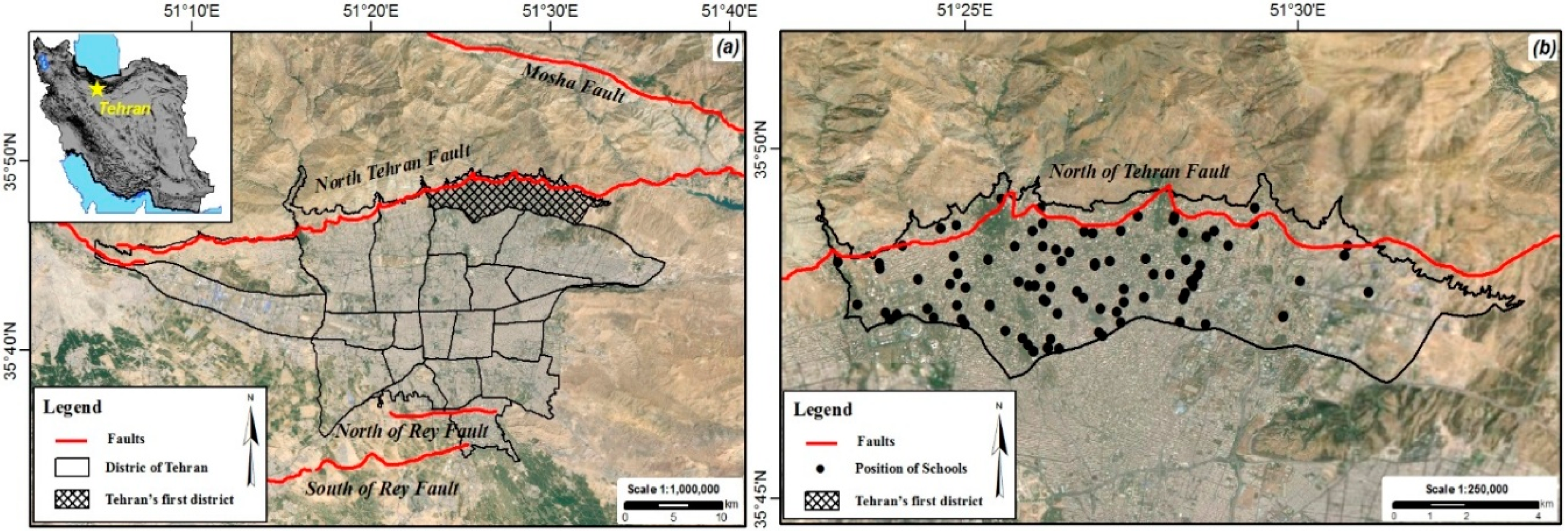
2. Description of the Study Area
3. Materials and Methods
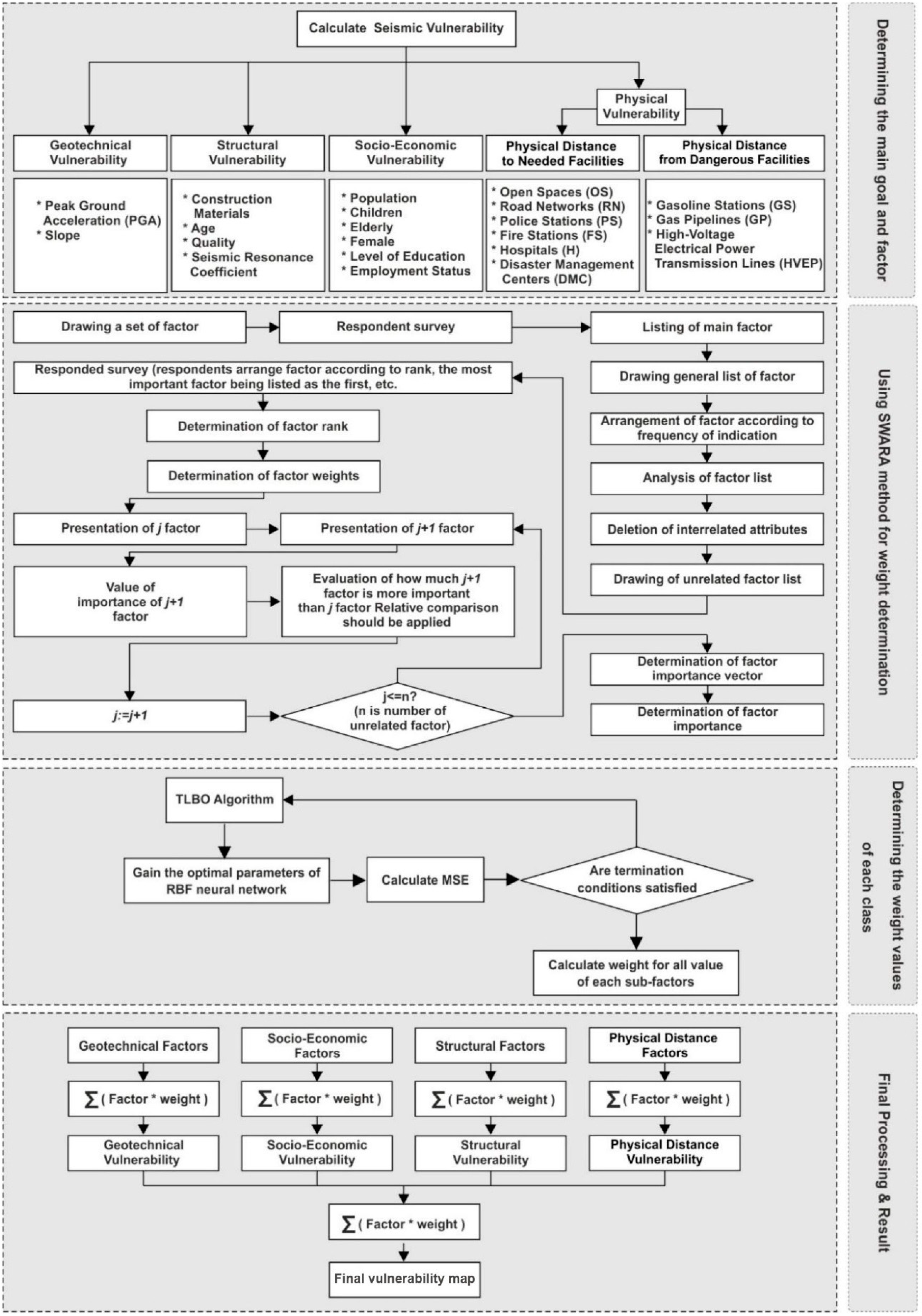
3.1. Determining the Main Goal and Criteria
3.2. Using the SWARA Method for Weight Determination
Factors Weighting
- -
- Determining the comparative importance of the average value :where, stands for the number of experts, shows the offered ranks by the experts for each factor, and j represents the number of the factor.
- -
- Determining the coefficient for each factor, as given in Equation (2):
- -
- Calculating the recalculated weight as follows:
- -
3.3. Optimization of Each Class’ Weight Values Related to Each Factor
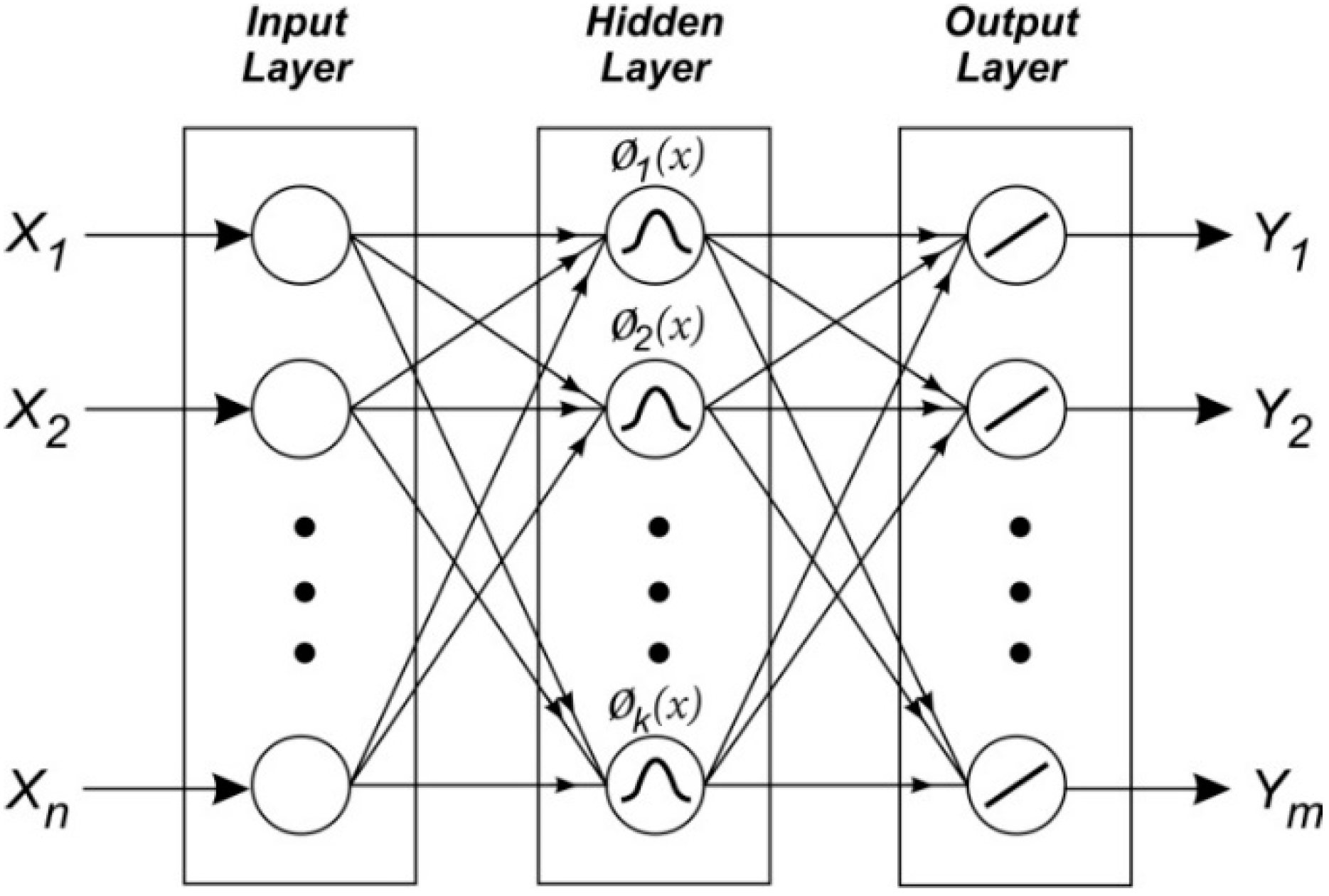
3.3.1. Radial Basis Function (RBF) Neural Network
3.3.2. TLBO Algorithm
Initialization
Teacher Phase
Learner Phase
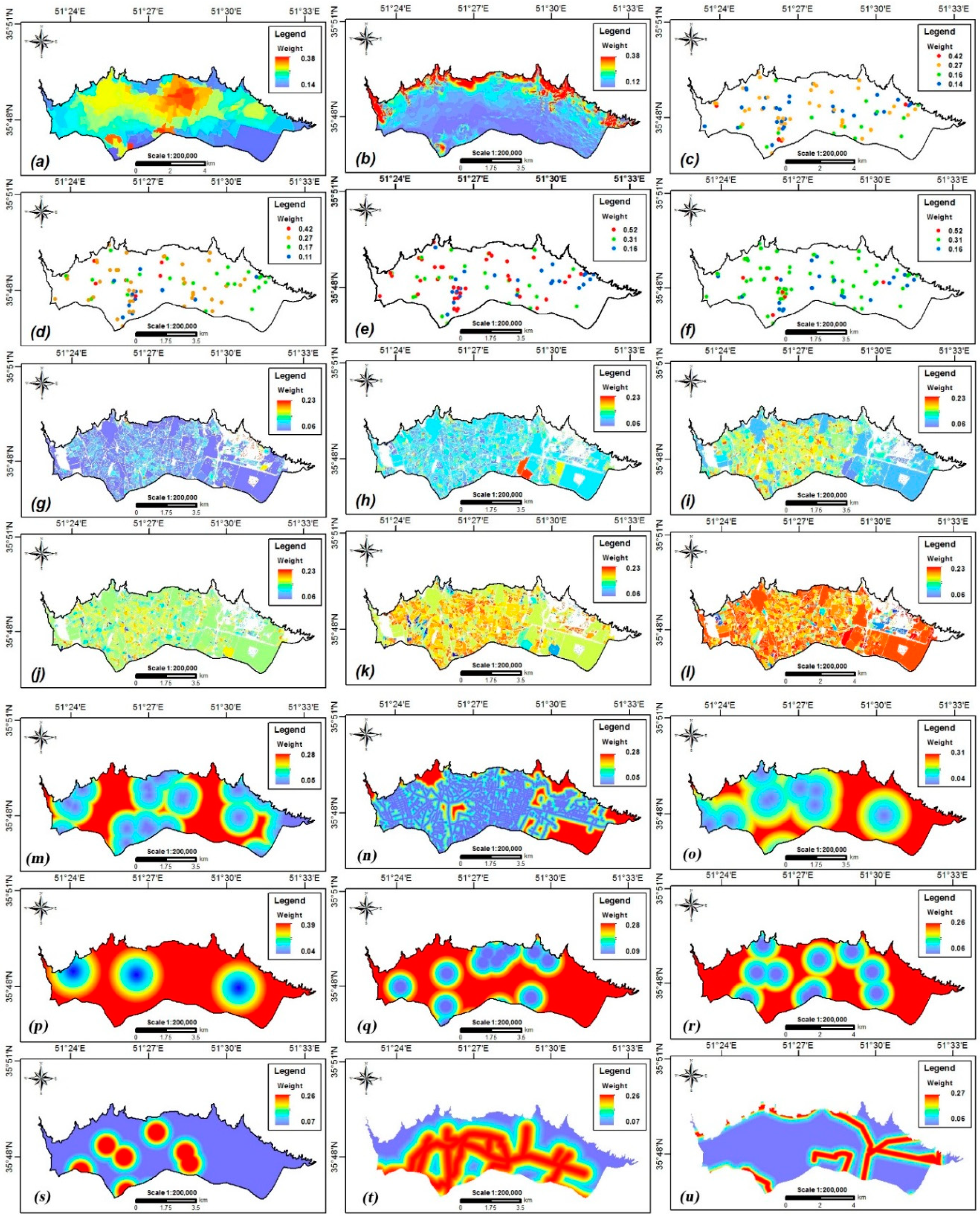
4. Results and Analysis
4.1. SWARA Weighting
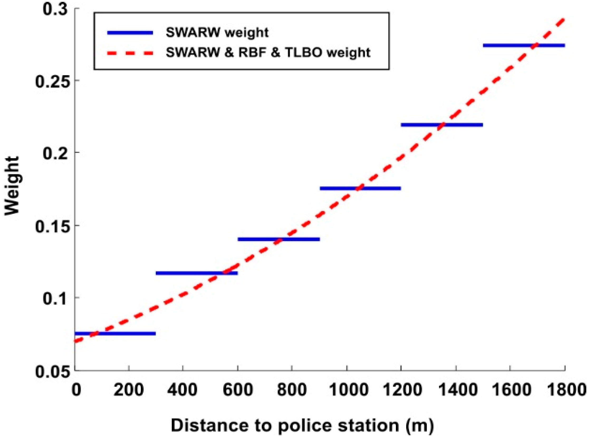
4.2. RBF and TLBO Algorithms to Optimize Class’ Weight
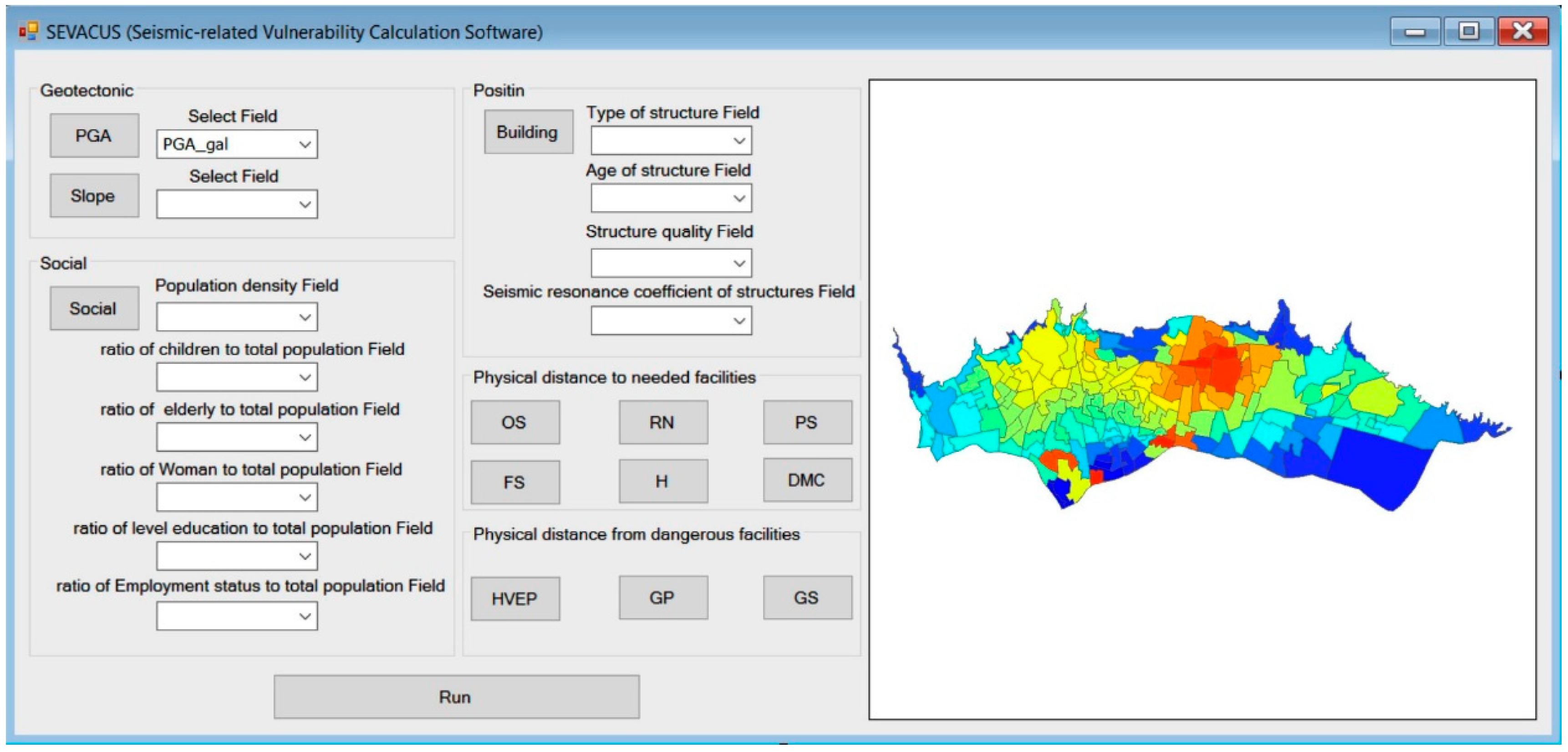
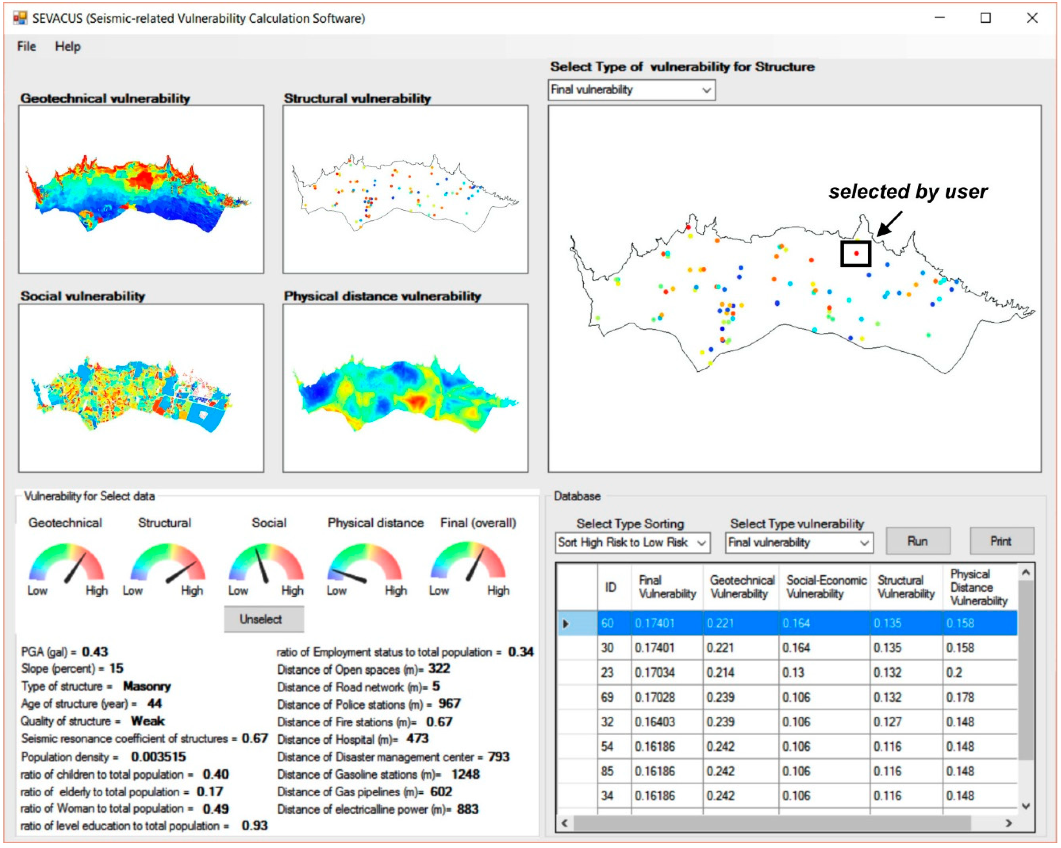
4.3. Producing the Final Seismic Vulnerability Map
- (1)
- The tool could be used to generate geotechnical, structural, socio-economic, and physical distance vulnerability maps in order to separately evaluate the four aforementioned vulnerabilities.
- (2)
- After providing the four vulnerabilities as separate contour maps, the vulnerability of the considered buildings was determined based on their geographical position. Finally, SEVUCAS calculated the overall vulnerability of the considered building by combining all four aforementioned vulnerabilities.
- (3)
- In some cases, a specific building had a great importance such that its seismic vulnerability assessment was included in a case study. The option “Gage” is designed in SEVUCAS to show each of the four abovementioned vulnerability items separately by clicking on that building in the software output window.
- (4)
- In this part, options have been designed to export the numeral vulnerabilities of buildings in the form of Excel worksheets. Moreover, it is possible to sort the considered buildings based on each of the considered vulnerabilities.
5. Discussion
6. Conclusions
Author Contributions
Funding
Conflicts of Interest
References
- Briggs, R.W.; Hayes, G.P. Introduction to the special issue on the 25 April 2015 Mw 7.8 Gorkha (Nepal) earthquake. Tectonophysics 2017, 714, 1–3. [Google Scholar]
- Alexander, D.C. Natural Disasters; Routledge: Abingdon, UK, 2017. [Google Scholar]
- Kagan, Y.Y. Are earthquakes predictable? Geophys. J. Int. 1997, 131, 505–525. [Google Scholar] [CrossRef] [Green Version]
- Coburn, A.; Spence, R. Earthquake Protection; John Wiley & Sons: Hoboken, NJ, USA, 2003. [Google Scholar]
- Moustra, M.; Avraamides, M.; Christodoulou, C. Artificial neural networks for earthquake prediction using time series magnitude data or Seismic Electric Signals. Expert Syst. Appl. 2011, 38, 15032–15039. [Google Scholar] [CrossRef]
- Armaş, I. Multi-criteria vulnerability analysis to earthquake hazard of Bucharest, Romania. Nat. Hazards 2012, 63, 1129–1156. [Google Scholar] [CrossRef]
- Armas, I.; Gavriș, A. Social vulnerability assessment using spatial multi-criteria analysis (SEVI model) and the Social Vulnerability Index (SoVI model)—A case study for Bucharest, Romania. Nat. Hazards Earth Syst. Sci. 2013, 13, 1481–1499. [Google Scholar] [CrossRef]
- Martins, V.N.; e Silva, D.S.; Cabral, P.; Silva, D.S. Social vulnerability assessment to seismic risk using multicriteria analysis: The case study of Vila Franca do Campo (São Miguel Island, Azores, Portugal). Nat. Hazards 2012, 62, 385–404. [Google Scholar] [CrossRef]
- Panahi, M.; Rezaie, F.; Meshkani, S.A. Seismic vulnerability assessment of school buildings in Tehran city based on AHP and GIS. Nat. Hazards Earth Syst. Sci. 2014, 14, 969–979. [Google Scholar] [CrossRef] [Green Version]
- Rezaie, F.; Panahi, M. GIS modeling of seismic vulnerability of residential fabrics considering geotechnical, structural, social and physical distance indicators in Tehran using multi-criteria decision-making techniques. Nat. Hazards Earth Syst. Sci. 2015, 15, 461–474. [Google Scholar] [CrossRef] [Green Version]
- Zebardast, E. Constructing a social vulnerability index to earthquake hazards using a hybrid factor analysis and analytic network process (f’anp) model. Nat. Hazards 2013, 65, 1331–1359. [Google Scholar] [CrossRef]
- Rashed, T.; Weeks, J. Assessing vulnerability to earthquake hazards through spatial multicriteria analysis of urban areas. Int. J. Geogr. Inf. Sci. 2003, 17, 547–576. [Google Scholar] [CrossRef]
- Alizadeh, M.; Hashim, M.; Alizadeh, E.; Shahabi, H.; Karami, M.R.; Pour, A.B.; Pradhan, B.; Zabihi, H. Multi-Criteria Decision Making (MCDM) Model for Seismic Vulnerability Assessment (SVA) of Urban Residential Buildings. ISPRS Int. J. Geo-Inf. 2018, 7, 444. [Google Scholar] [CrossRef]
- Tesfamariam, S.; Saatcioglu, M. Seismic Vulnerability Assessment of Reinforced Concrete Buildings Using Hierarchical Fuzzy Rule Base Modeling. Earthq. Spectra 2010, 26, 235–256. [Google Scholar] [CrossRef]
- Şen, Z. Rapid visual earthquake hazard evaluation of existing buildings by fuzzy logic modeling. Expert Syst. Appl. 2010, 37, 5653–5660. [Google Scholar] [CrossRef]
- Şen, Z. Supervised fuzzy logic modeling for building earthquake hazard assessment. Expert Syst. Appl. 2011, 38, 14564–14573. [Google Scholar] [CrossRef]
- Aghataher, R.; Delavar, M.; Nami, M.; Samnay, N. A fuzzy-ahp decision support system for evaluation of cities vulnerability against earthquakes. World Appl. Sci. J. 2008, 3, 66–72. [Google Scholar]
- Moradi, M.; Delavar, M.R.; Moshiri, B. A gis-based multi-criteria decision-making approach for seismic vulnerability assessment using quantifier-guided owa operator: A case study of Tehran, Iran. Ann. GIS 2015, 21, 209–222. [Google Scholar] [CrossRef]
- Nyimbili, P.H.; Erden, T.; Karaman, H. Integration of GIS, AHP and TOPSIS for earthquake hazard analysis. Nat. Hazards 2018, 92, 1523–1546. [Google Scholar] [CrossRef]
- Alam, M.S.; Haque, S.M. Assessment of Urban Physical Seismic Vulnerability Using the Combination of AHP and TOPSIS Models: A Case Study of Residential Neighborhoods of Mymensingh City, Bangladesh. J. Geosci. Environ. Prot. 2018, 6, 165–183. [Google Scholar] [CrossRef] [Green Version]
- Yousefi, A.; Ahamad, M.S.S.; Majid, T.A. Application of Topsis Method in Prioritization of Highway Bridges for Seismic Retrofitting. Eng. Struct. Technol. 2014, 6, 114–123. [Google Scholar] [CrossRef]
- Khosravi, K.; Sartaj, M.; Tsai, F.T.-C.; Singh, V.P.; Kazakis, N.; Melesse, A.M.; Prakash, I.; Bui, D.T.; Pham, B.T. A comparison study of DRASTIC methods with various objective methods for groundwater vulnerability assessment. Sci. Total Environ. 2018, 642, 1032–1049. [Google Scholar] [CrossRef]
- Bui, D.T.; Panahi, M.; Shahabi, H.; Singh, V.P.; Shirzadi, A.; Chapi, K.; Khosravi, K.; Chen, W.; Panahi, S.; Li, S.; et al. Novel Hybrid Evolutionary Algorithms for Spatial Prediction of Floods. Sci. Rep. 2018, 8, 15364. [Google Scholar] [CrossRef]
- Alizadeh, M.; Ngah, I.; Hashim, M.; Pradhan, B.; Pour, A.B. A Hybrid Analytic Network Process and Artificial Neural Network (ANP-ANN) Model for Urban Earthquake Vulnerability Assessment. Remote Sens. 2018, 10, 975. [Google Scholar] [CrossRef]
- Vrochidou, E.; Alvanitopoulos, P.-F.; Andreadis, I.; Elenas, A.; Alvanitopoulos, P.-F. Structural damage estimation in mid-rise reinforced concrete structure based on time–frequency analysis of seismic accelerograms. IET Sci. Meas. Technol. 2016, 10, 900–909. [Google Scholar] [CrossRef]
- Ghorbanzadeh, O.; Blaschke, T.; Aryal, J.; Gholaminia, K. A new GIS-based technique using an adaptive neuro-fuzzy inference system for land subsidence susceptibility mapping. J. Spat. Sci. 2018, 1–17. [Google Scholar] [CrossRef]
- Zheng, Y.-J.; Chen, S.-Y.; Ling, H.-F. Evolutionary optimization for disaster relief operations: A survey. Appl. Soft Comput. 2015, 27, 553–566. [Google Scholar] [CrossRef]
- Bagheripour, M.H.; Shooshpasha, I.; Afzalirad, M. A genetic algorithm approach for assessing soil liquefaction potential based on reliability method. J. Earth Syst. Sci. 2012, 121, 45–62. [Google Scholar] [CrossRef] [Green Version]
- Tao, Z.-R.; Tao, X.-X. Genetic algorithm in vulnerability evaluation. In Proceedings of the 2009 International Conference on Artificial Intelligence and Computational Intelligence, Shanghai, China, 7–8 November 2009; pp. 392–396. [Google Scholar]
- Adineh, F.; Motamedvaziri, B.; Ahmadi, H.; Moeini, A. Landslide susceptibility mapping using Genetic Algorithm for the Rule Set Production (GARP) model. J. Mt. Sci. 2018, 15, 2013–2026. [Google Scholar] [CrossRef]
- Aghdam, I.N.; Pradhan, B.; Panahi, M. Landslide susceptibility assessment using a novel hybrid model of statistical bivariate methods (FR and WOE) and adaptive neuro-fuzzy inference system (ANFIS) at southern Zagros Mountains in Iran. Environ. Earth Sci. 2017, 76, 21. [Google Scholar] [CrossRef]
- Khosravi, K.; Shahabi, H.; Pham, B.T.; Adamowski, J.; Shirzadi, A.; Pradhan, B.; Dou, J.; Ly, H.-B.; Gróf, G.; Ho, H.L.; et al. A comparative assessment of flood susceptibility modeling using Multi-Criteria Decision-Making Analysis and Machine Learning Methods. J. Hydrol. 2019, 573, 311–323. [Google Scholar] [CrossRef]
- Chapi, K.; Singh, V.P.; Shirzadi, A.; Shahabi, H.; Bui, D.T.; Pham, B.T.; Khosravi, K. A novel hybrid artificial intelligence approach for flood susceptibility assessment. Environ. Model. Softw. 2017, 95, 229–245. [Google Scholar] [CrossRef]
- Khosravi, K.; Pham, B.T.; Chapi, K.; Shirzadi, A.; Shahabi, H.; Revhaug, I.; Prakash, I.; Bui, D.T. A comparative assessment of decision trees algorithms for flash flood susceptibility modeling at Haraz watershed, northern Iran. Sci. Total Environ. 2018, 627, 744–755. [Google Scholar] [CrossRef]
- Bui, D.T.; Khosravi, K.; Li, S.; Shahabi, H.; Panahi, M.; Singh, V.P.; Chapi, K.; Shirzadi, A.; Panahi, S.; Chen, W.; et al. New Hybrids of ANFIS with Several Optimization Algorithms for Flood Susceptibility Modeling. Water 2018, 10, 1210. [Google Scholar] [Green Version]
- Shafizadeh-Moghadam, H.; Valavi, R.; Shahabi, H.; Chapi, K.; Shirzadi, A. Novel forecasting approaches using combination of machine learning and statistical models for flood susceptibility mapping. J. Environ. Manag. 2018, 217, 1–11. [Google Scholar] [CrossRef] [Green Version]
- Ahmadlou, M.; Karimi, M.; Alizadeh, S.; Shirzadi, A.; Parvinnejhad, D.; Shahabi, H.; Panahi, M.; Parvinnejad, D. Flood susceptibility assessment using integration of adaptive network-based fuzzy inference system (ANFIS) and biogeography-based optimization (BBO) and BAT algorithms (BA). Geocarto Int. 2018, 1–21. [Google Scholar] [CrossRef]
- Chen, W.; Hong, H.; Li, S.; Shahabi, H.; Wang, Y.; Wang, X.; Bin Ahmad, B. Flood susceptibility modelling using novel hybrid approach of reduced-error pruning trees with bagging and random subspace ensembles. J. Hydrol. 2019, 575, 864–873. [Google Scholar] [CrossRef]
- Wang, Y.; Hong, H.; Chen, W.; Li, S.; Panahi, M.; Khosravi, K.; Shirzadi, A.; Shahabi, H.; Panahi, S.; Costache, R. Flood susceptibility mapping in dingnan county (China) using adaptive neuro-fuzzy inference system with biogeography based optimization and imperialistic competitive algorithm. J. Environ. Manag. 2019, 247, 712–729. [Google Scholar] [CrossRef]
- Bui, D.T.; Khosravi, K.; Shahabi, H.; Daggupati, P.; Adamowski, J.F.; Melesse, A.M.; Pham, B.T.; Pourghasemi, H.R.; Mahmoudi, M.; Bahrami, S.; et al. Flood Spatial Modeling in Northern Iran Using Remote Sensing and GIS: A Comparison between Evidential Belief Functions and Its Ensemble with a Multivariate Logistic Regression Model. Remote Sens. 2019, 11, 1589. [Google Scholar]
- Chen, W.; Shirzadi, A.; Shahabi, H.; Bin Ahmad, B.; Zhang, S.; Hong, H.; Zhang, N. A novel hybrid artificial intelligence approach based on the rotation forest ensemble and naïve Bayes tree classifiers for a landslide susceptibility assessment in Langao County, China. Geomat. Nat. Hazards Risk 2017, 8, 1955–1977. [Google Scholar] [CrossRef]
- Chen, W.; Shahabi, H.; Shirzadi, A.; Li, T.; Guo, C.; Hong, H.; Li, W.; Pan, D.; Hui, J.; Ma, M.; et al. A novel ensemble approach of bivariate statistical-based logistic model tree classifier for landslide susceptibility assessment. Geocarto Int. 2018, 33, 1398–1420. [Google Scholar] [CrossRef]
- Pham, B.T.; Shirzadi, A.; Bui, D.T.; Prakash, I.; Dholakia, M. A hybrid machine learning ensemble approach based on a Radial Basis Function neural network and Rotation Forest for landslide susceptibility modeling: A case study in the Himalayan area, India. Int. J. Sediment Res. 2018, 33, 157–170. [Google Scholar] [CrossRef]
- Abedini, M.; Ghasemian, B.; Shirzadi, A.; Shahabi, H.; Chapi, K.; Pham, B.T.; Bin Ahmad, B.; Bui, D.T. A Novel Hybrid Approach of Bayesian Logistic Regression and Its Ensembles for Landslide Susceptibility Assessment. Geocarto Int. 2018, 1–44. [Google Scholar] [CrossRef]
- Bui, D.T.; Shahabi, H.; Shirzadi, A.; Chapi, K.; Hoang, N.-D.; Pham, B.T.; Bui, Q.-T.; Tran, C.-T.; Panahi, M.; Bin Ahmad, B.; et al. A Novel Integrated Approach of Relevance Vector Machine Optimized by Imperialist Competitive Algorithm for Spatial Modeling of Shallow Landslides. Remote Sens. 2018, 10, 1538. [Google Scholar] [Green Version]
- Jaafari, A.; Panahi, M.; Pham, B.T.; Shahabi, H.; Bui, D.T.; Rezaie, F.; Lee, S. Meta optimization of an adaptive neuro-fuzzy inference system with grey wolf optimizer and biogeography-based optimization algorithms for spatial prediction of landslide susceptibility. Catena 2019, 175, 430–445. [Google Scholar] [CrossRef]
- Nguyen, V.V.; Pham, B.T.; Vu, B.T.; Prakash, I.; Jha, S.; Shahabi, H.; Shirzadi, A.; Ba, D.N.; Kumar, R.; Chatterjee, J.M.; et al. Hybrid Machine Learning Approaches for Landslide Susceptibility Modeling. Forests 2019, 10, 157. [Google Scholar] [CrossRef]
- Bui, D.T.; Shahabi, H.; Omidvar, E.; Shirzadi, A.; Geertsema, M.; Clague, J.J.; Khosravi, K.; Pradhan, B.; Pham, B.T.; Chapi, K.; et al. Shallow Landslide Prediction Using a Novel Hybrid Functional Machine Learning Algorithm. Remote Sens. 2019, 11, 931. [Google Scholar] [Green Version]
- Zhang, T.; Han, L.; Chen, W.; Shahabi, H. Hybrid Integration Approach of Entropy with Logistic Regression and Support Vector Machine for Landslide Susceptibility Modeling. Entropy 2018, 20, 884. [Google Scholar] [CrossRef]
- Chen, W.; Shahabi, H.; Zhang, S.; Khosravi, K.; Shirzadi, A.; Chapi, K.; Pham, B.T.; Zhang, T.; Zhang, L.; Chai, H.; et al. Landslide Susceptibility Modeling Based on GIS and Novel Bagging-Based Kernel Logistic Regression. Appl. Sci. 2018, 8, 2540. [Google Scholar] [CrossRef]
- Bui, D.T.; Shahabi, H.; Shirzadi, A.; Chapi, K.; Alizadeh, M.; Chen, W.; Mohammadi, A.; Ahmad, B.; Panahi, M.; Hong, H.; et al. Landslide Detection and Susceptibility Mapping by AIRSAR Data Using Support Vector Machine and Index of Entropy Models in Cameron Highlands, Malaysia. Remote Sens. 2018, 10, 1527. [Google Scholar] [Green Version]
- Chen, W.; Peng, J.; Hong, H.; Shahabi, H.; Pradhan, B.; Liu, J.; Zhu, A.-X.; Pei, X.; Duan, Z. Landslide susceptibility modelling using GIS-based machine learning techniques for Chongren County, Jiangxi Province, China. Sci. Total Environ. 2018, 626, 1121–1135. [Google Scholar] [CrossRef]
- Chen, W.; Shahabi, H.; Shirzadi, A.; Hong, H.; Akgun, A.; Tian, Y.; Liu, J.; Zhu, A.-X.; Li, S. Novel hybrid artificial intelligence approach of bivariate statistical-methods-based kernel logistic regression classifier for landslide susceptibility modeling. Bull. Int. Assoc. Eng. Geol. 2018, 1–23. [Google Scholar] [CrossRef]
- Roodposhti, M.S.; Aryal, J.; Shahabi, H.; Safarrad, T. Fuzzy Shannon Entropy: A Hybrid GIS-Based Landslide Susceptibility Mapping Method. Entropy 2016, 18, 343. [Google Scholar] [CrossRef]
- Pham, B.T.; Prakash, I.; Khosravi, K.; Chapi, K.; Trinh, P.T.; Ngo, T.Q.; Hosseini, S.V.; Bui, D.T. A Comparison of Support Vector Machines and Bayesian Algorithms for Landslide Susceptibility Modeling. Geocarto Int. 2018, 1–36. [Google Scholar] [CrossRef]
- Shirzadi, A.; Solaimani, K.; Roshan, M.H.; Kavian, A.; Chapi, K.; Shahabi, H.; Keesstra, S.; Bin Ahmad, B.; Bui, D.T. Uncertainties of prediction accuracy in shallow landslide modeling: Sample size and raster resolution. Catena 2019, 178, 172–188. [Google Scholar] [CrossRef]
- He, Q.; Shahabi, H.; Shirzadi, A.; Li, S.; Chen, W.; Wang, N.; Chai, H.; Bian, H.; Ma, J.; Chen, Y.; et al. Landslide spatial modelling using novel bivariate statistical based Naïve Bayes, RBF Classifier, and RBF Network machine learning algorithms. Sci. Total Environ. 2019, 663, 1–15. [Google Scholar] [CrossRef]
- Hong, H.; Shahabi, H.; Shirzadi, A.; Chen, W.; Chapi, K.; Ahmad, B.B.; Roodposhti, M.S.; Hesar, A.Y.; Tian, Y.; Bui, D.T. Landslide susceptibility assessment at the wuning area, china: A comparison between multi-criteria decision making, bivariate statistical and machine learning methods. Nat. Hazards 2019, 96, 173–212. [Google Scholar] [CrossRef]
- Chen, W.; Panahi, M.; Tsangaratos, P.; Shahabi, H.; Ilia, I.; Panahi, S.; Li, S.; Jaafari, A.; Bin Ahmad, B. Applying population-based evolutionary algorithms and a neuro-fuzzy system for modeling landslide susceptibility. Catena 2019, 172, 212–231. [Google Scholar] [CrossRef]
- Chen, W.; Zhang, S.; Li, R.; Shahabi, H. Performance evaluation of the GIS-based data mining techniques of best-first decision tree, random forest, and naïve Bayes tree for landslide susceptibility modeling. Sci. Total Environ. 2018, 644, 1006–1018. [Google Scholar] [CrossRef]
- Shirzadi, A.; Soliamani, K.; Habibnejhad, M.; Kavian, A.; Chapi, K.; Shahabi, H.; Chen, W.; Khosravi, K.; Pham, B.T.; Pradhan, B.; et al. Novel GIS Based Machine Learning Algorithms for Shallow Landslide Susceptibility Mapping. Sensors 2018, 18, 3777. [Google Scholar] [CrossRef]
- Shirzadi, A.; Shahabi, H.; Chapi, K.; Bui, D.T.; Pham, B.T.; Shahedi, K.; Bin Ahmad, B. A comparative study between popular statistical and machine learning methods for simulating volume of landslides. Catena 2017, 157, 213–226. [Google Scholar] [CrossRef]
- Shahabi, H.; Hashim, M. Landslide susceptibility mapping using GIS-based statistical models and Remote sensing data in tropical environment. Sci. Rep. 2015, 5, 9899. [Google Scholar] [CrossRef] [Green Version]
- Shafizadeh-Moghadam, H.; Minaei, M.; Shahabi, H.; Hagenauer, J. Big data in geohazard; pattern mining and large scale analysis of landslides in Iran. Earth Sci. Inform. 2019, 12, 1–17. [Google Scholar] [CrossRef]
- Nguyen, P.T.; Tuyen, T.T.; Shirzadi, A.; Pham, B.T.; Shahabi, H.; Omidvar, E.; Amini, A.; Entezami, H.; Prakash, I.; Van Phong, T.; et al. Development of a Novel Hybrid Intelligence Approach for Landslide Spatial Prediction. Appl. Sci. 2019, 9, 2824. [Google Scholar] [CrossRef]
- Jaafari, A.; Zenner, E.K.; Panahi, M.; Shahabi, H. Hybrid artificial intelligence models based on a neuro-fuzzy system and metaheuristic optimization algorithms for spatial prediction of wildfire probability. Agric. For. Meteorol. 2019, 266, 198–207. [Google Scholar] [CrossRef]
- Taheri, K.; Shahabi, H.; Chapi, K.; Shirzadi, A.; Gutiérrez, F.; Khosravi, K. Sinkhole susceptibility mapping: A comparison between bayes-based machine learning algorithms. Land Degrad. Dev. 2019, 30, 730–745. [Google Scholar] [CrossRef]
- Roodposhti, M.S.; Safarrad, T.; Shahabi, H. Drought sensitivity mapping using two one-class support vector machine algorithms. Atmos. Res. 2017, 193, 73–82. [Google Scholar] [CrossRef]
- Azareh, A.; Rahmati, O.; Rafiei-Sardooi, E.; Sankey, J.B.; Lee, S.; Shahabi, H.; Bin Ahmad, B. Modelling gully-erosion susceptibility in a semi-arid region, Iran: Investigation of applicability of certainty factor and maximum entropy models. Sci. Total Environ. 2019, 655, 684–696. [Google Scholar] [CrossRef]
- Bui, D.T.; Shirzadi, A.; Shahabi, H.; Chapi, K.; Omidavr, E.; Pham, B.T.; Asl, D.T.; Khaledian, H.; Pradhan, B.; Panahi, M.; et al. A Novel Ensemble Artificial Intelligence Approach for Gully Erosion Mapping in a Semi-Arid Watershed (Iran). Sensors 2019, 19, 2444. [Google Scholar] [Green Version]
- Miraki, S.; Zanganeh, S.H.; Chapi, K.; Singh, V.P.; Shirzadi, A.; Shahabi, H.; Pham, B.T. Mapping groundwater potential using a novel hybrid intelligence approach. Water Resour. Manag. 2019, 33, 281–302. [Google Scholar] [CrossRef]
- Rahmati, O.; Naghibi, S.A.; Shahabi, H.; Bui, D.T.; Pradhan, B.; Azareh, A.; Rafiei-Sardooi, E.; Samani, A.N.; Melesse, A.M. Groundwater spring potential modelling: Comprising the capability and robustness of three different modeling approaches. J. Hydrol. 2018, 565, 248–261. [Google Scholar] [CrossRef]
- Chen, W.; Panahi, M.; Khosravi, K.; Pourghasemi, H.R.; Rezaie, F.; Parvinnezhad, D. Spatial prediction of groundwater potentiality using ANFIS ensembled with teaching-learning-based and biogeography-based optimization. J. Hydrol. 2019, 572, 435–448. [Google Scholar] [CrossRef]
- Rahmati, O.; Choubin, B.; Fathabadi, A.; Coulon, F.; Soltani, E.; Shahabi, H.; Mollaefar, E.; Tiefenbacher, J.; Cipullo, S.; Ahmad, B.B. Predicting uncertainty of machine learning models for modelling nitrate pollution of groundwater using quantile regression and uneec methods. Sci. Total Environ. 2019, 688, 855–866. [Google Scholar] [CrossRef]
- Dreiseitl, S.; Ohno-Machado, L. Logistic regression and artificial neural network classification models: A methodology review. J. Biomed. Inform. 2002, 35, 352–359. [Google Scholar] [CrossRef]
- Khosravi, K.; Panahi, M.; Bui, D.T. Spatial prediction of groundwater spring potential mapping based on an adaptive neuro-fuzzy inference system and metaheuristic optimization. Hydrol. Earth Syst. Sci. 2018, 22, 4771–4792. [Google Scholar] [CrossRef] [Green Version]
- SCI. Available online: https://www.amar.org.ir/english/Population-and-Housing-Censuses (accessed on 1 January 2016).
- Jafari, M.A. Statistical prediction of the next great earthquake around Tehran, Iran. J. Geodyn. 2010, 49, 14–18. [Google Scholar] [CrossRef]
- Keršulienė, V.; Zavadskas, E.K.; Turskis, Z. Selection of Rational Dispute Resolution Method by Applying New Step-Wise Weight Assessment Ratio Analysis (Swara). J. Bus. Econ. Manag. 2010, 11, 243–258. [Google Scholar] [CrossRef]
- Vafaeipour, M.; Zolfani, S.H.; Varzandeh, M.H.M.; Derakhti, A.; Eshkalag, M.K. Assessment of regions priority for implementation of solar projects in Iran: New application of a hybrid multi-criteria decision making approach. Energy Convers. Manag. 2014, 86, 653–663. [Google Scholar] [CrossRef]
- Mardani, A.; Nilashi, M.; Zakuan, N.; Loganathan, N.; Soheilirad, S.; Saman, M.Z.M.; Ibrahim, O. A systematic review and meta-Analysis of SWARA and WASPAS methods: Theory and applications with recent fuzzy developments. Appl. Soft Comput. 2017, 57, 265–292. [Google Scholar] [CrossRef] [Green Version]
- Zolfani, S.H.; Yazdani, M.; Zavadskas, E.K. An extended stepwise weight assessment ratio analysis (SWARA) method for improving criteria prioritization process. Soft Comput. 2018, 22, 7399–7405. [Google Scholar] [CrossRef]
- Aghdaie, M.H.; Zolfani, S.H.; Zavadskas, E.K. Synergies of Data Mining and Multiple Attribute Decision Making. Procedia-Soc. Behav. Sci. 2014, 110, 767–776. [Google Scholar] [CrossRef] [Green Version]
- Karabasevic, D.; Stanujkic, D.; Urosevic, S.; Popovic, G.; Maksimovic, M. An Approach to Criteria Weights Determination by Integrating the DELPHI and the Adapted SWARA Methods. Manag. Sustain. Bus. Manag. Solut. Emerg. Econ. 2017, 22, 15–25. [Google Scholar] [CrossRef] [Green Version]
- Chen, H.-Y.; Leou, J.-J. Saliency-directed image interpolation using particle swarm optimization. Signal Process. 2010, 90, 1676–1692. [Google Scholar] [CrossRef]
- Mansouri, P.; Asady, B.; Gupta, N. An approximation algorithm for fuzzy polynomial interpolation with Artificial Bee Colony algorithm. Appl. Soft Comput. 2013, 13, 1997–2002. [Google Scholar] [CrossRef]
- Kurtulus, B.; Flipo, N. Hydraulic head interpolation using anfis—Model selection and sensitivity analysis. Comput. Geosci. 2012, 38, 43–51. [Google Scholar] [CrossRef]
- Kindelan, M.; Moscoso, M.; González-Rodríguez, P. Radial basis function interpolation in the limit of increasingly flat basis functions. J. Comput. Phys. 2016, 307, 225–242. [Google Scholar] [CrossRef]
- Broomhead, D.S.; Lowe, D. Radial Basis Functions, Multi-Variable Functional Interpolation and Adaptive Networks; Royal Signals and Radar Establishment Malvern: Malvern, UK, 1988. [Google Scholar]
- Bianchini, M.; Frasconi, P.; Gori, M. Learning without local minima in radial basis function networks. IEEE Trans. Neural Netw. 1995, 6, 749–756. [Google Scholar] [CrossRef] [Green Version]
- Buhmann, M.D. Radial Basis Functions: Theory and Implementations; Cambridge University Press: Cambridge, UK, 2003; Volume 12. [Google Scholar]
- Yu, L.; Huang, W.; Lai, K.K.; Wang, S. A reliability-based rbf network ensemble model for foreign exchange rates predication. In International Conference on Neural Information Processing; Springer: Berlin/Heidelberg, Germany, 2006; pp. 380–389. [Google Scholar]
- Panahi, M.; Yekrangnia, M.; Bagheri, Z.; Pourghasemi, H.R.; Rezaie, F.; Aghdam, I.N.; Damavandi, A.A. GIS-Based SWARA and Its Ensemble by RBF and ICA Data-Mining Techniques for Determining Suitability of Existing Schools and Site Selection of New School Buildings. In Spatial Modeling in GIS and R for Earth and Environmental Sciences; Pourghasemi, H.R., Gokceoglu, C., Eds.; Elsevier: Amsterdam, The Netherlands, 2019; pp. 161–188. [Google Scholar]
- Rao, R.; Savsani, V.; Vakharia, D.; Savsani, V. Teaching–learning-based optimization: A novel method for constrained mechanical design optimization problems. Comput. Des. 2011, 43, 303–315. [Google Scholar] [CrossRef]
- Wu, Z.-S.; Fu, W.-P.; Xue, R. Nonlinear Inertia Weighted Teaching-Learning-Based Optimization for Solving Global Optimization Problem. Comput. Intell. Neurosci. 2015, 2015, 1–15. [Google Scholar] [CrossRef] [Green Version]
- Babayev, G.; Ismail-Zadeh, A.; Le Mouel, J.-L. Scenario-based earthquake hazard and risk assessment for Baku (Azerbaijan). Nat. Hazards Earth Syst. Sci. 2010, 10, 2697–2712. [Google Scholar] [CrossRef] [Green Version]
- Harp, E.L.; Wilson, R.C. Shaking intensity thresholds for rock falls and slides: Evidence from 1987 whittier narrows and superstition hills earthquake strong-motion records. Bull. Seismol. Soc. Am. 1995, 85, 1739–1757. [Google Scholar]
- Alinia, H.S.; Delavar, M.R. Tehran’s seismic vulnerability classification using granular computing approach. Appl. Geomat. 2011, 3, 229–240. [Google Scholar] [CrossRef]
- Shirley, W.L.; Boruff, B.J.; Cutter, S.L. Social vulnerability to environmental hazards. In Hazards Vulnerability and Environmental Justice; Routledge: Abingdon, UK, 2012; pp. 143–160. [Google Scholar]
- Tavakoli, B.; Favakoli, A. Estimating the vulnerability and loss functions of residential buildings. Nat. Hazards 1993, 7, 155–171. [Google Scholar] [CrossRef]
- Chakraborty, J.; Tobin, G.A.; Montz, B.E. Population Evacuation: Assessing Spatial Variability in Geophysical Risk and Social Vulnerability to Natural Hazards. Nat. Hazards Rev. 2005, 6, 23–33. [Google Scholar] [CrossRef]
- Peng, Y. Regional earthquake vulnerability assessment using a combination of mcdm methods. Ann. Oper. Res. 2015, 234, 95–110. [Google Scholar] [CrossRef]
- Birkmann, J. Risk and vulnerability indicators at different scales: Applicability, usefulness and policy implications. Environ. Hazards 2007, 7, 20–31. [Google Scholar] [CrossRef]
- Dwyer, A.; Zoppou, C.; Nielsen, O.; Day, S.; Roberts, S. Quantifying Social Vulnerability: A Methodology for Identifying Those at Risk to Natural Hazards; Geoscience Australia Record: Canberra, Australia, 2004; pp. 158–179. [Google Scholar]
- Granger, K.; Jones, T.G.; Leiba, M.; Scott, G. Community risk in cairns: A multi-hazard risk assessment. Aust. J. Emerg. Manag. 1999, 14, 25. [Google Scholar]
- King, D.; MacGregor, C. Using social indicators to measure community vulnerability to natural hazards. Aust. J. Emerg. Manag. 2000, 15, 52. [Google Scholar]
- Kuhlicke, C.; Scolobig, A.; Tapsell, S.; Steinführer, A.; De Marchi, B.; Marchi, B. Contextualizing social vulnerability: Findings from case studies across Europe. Nat. Hazards 2011, 58, 789–810. [Google Scholar] [CrossRef]
- Steinführer, A. Social vulnerability and the 2002 flood. In Country Report Germany (Mulde River); T11-07-08; Helmholz Unweltforschungszentrum (UFZ): Leipzig, Germany, 2007. [Google Scholar]
- Ebert, A.; Kerle, N. Urban social vulnerability assessment using object-oriented analysis of remote sensing and gis data. A case study for Tegucigalpa, Honduras. Int. Arch. Photogramm. Remote Sens. Spat. Inf. Sci. 2008, 37, 1307–1312. [Google Scholar]
- Hellström, T. Critical infrastructure and systemic vulnerability: Towards a planning framework. Saf. Sci. 2007, 45, 415–430. [Google Scholar] [CrossRef]
- Hizbaron, D.R.; Baiquni, M.; Sartohadi, J.; Rijanta, R.; Coy, M. Assessing social vulnerability to seismic hazard through spatial multi criteria evaluation in Bantul district, Indonesia. In Proceedings of the Conference of Development on the Margin, Bonn, Germany, 5–7 October 2011. [Google Scholar]
- Zhang, N.; Huang, H. Social vulnerability for public safety: A case study of Beijing, China. Chin. Sci. Bull. 2013, 58, 2387–2394. [Google Scholar] [CrossRef] [Green Version]
- Karimzadeh, S.; Miyajima, M.; Hassanzadeh, R.; Amiraslanzadeh, R.; Kamel, B. A GIS-based seismic hazard, building vulnerability and human loss assessment for the earthquake scenario in Tabriz. Soil Dyn. Earthq. Eng. 2014, 66, 263–280. [Google Scholar] [CrossRef]
- Frigerio, I.; Ventura, S.; Strigaro, D.; Mattavelli, M.; De Amicis, M.; Mugnano, S.; Boffi, M. A GIS-based approach to identify the spatial variability of social vulnerability to seismic hazard in Italy. Appl. Geogr. 2016, 74, 12–22. [Google Scholar] [CrossRef]


| Radial Basis Function | Function Expression |
|---|---|
| Thin-plate spline (TPS) | |
| Gaussian (G) | |
| Multi-quadrics (MQ) | |
| Inverse multi-quadrics (IMQ) |
| Alternatives (Sub-Indicators) | Sj | Kj | Qj | Wj | Description | References |
|---|---|---|---|---|---|---|
| Geotechnical | ||||||
| Peak ground acceleration (PGA) | - | 1.00 | 1.00 | 0.61 | Earth movement during earthquakes | [9,96,97] |
| Slope | 0.55 | 1.55 | 0.65 | 0.39 | Surface stability and landslide severity | |
| Structural | ||||||
| Construction materials of structures | - | 1.00 | 1.00 | 0.34 | - | [10,15,98,99,100] |
| Age of construction | 0.35 | 1.35 | 0.74 | 0.26 | Degradation in the structural system | |
| Structure quality | 0.15 | 1.15 | 0.64 | 0.22 | Quality of workmanship and supervision | |
| Seismic resonance coefficient of structures | 0.25 | 1.25 | 0.52 | 0.18 | Closeness of natural frequency of structure and the dominant frequency of ground motion | |
| Socio-Economic | ||||||
| Population density | - | 1.00 | 1.00 | 0.28 | Reduction in the ability of rescue | [10,99,101,102,103,104,105,106,107,108] |
| Children population density | 0.55 | 1.55 | 0.65 | 0.18 | Physical vulnerability; lack of training and emotional dependencies | |
| Elderly population density | 0.00 | 1.00 | 0.65 | 0.18 | Physical vulnerability; possibility of illness | |
| Female population density | 0.20 | 1.20 | 0.54 | 0.15 | - | |
| Population of education level density | 0.10 | 1.10 | 0.49 | 0.14 | Education for performing post-disaster undertakings and helping rescue teams | |
| Population of employment status density | 0.70 | 1.70 | 0.29 | 0.08 | Further helping rescue teams | |
| Physical Distance to Needed Facilities | ||||||
| Open spaces (OS) | - | 1.00 | 1.00 | 0.25 | Closeness to immediate occupancy sites/undamaged buildings | [10,12,109,110,111,112] |
| Road network (RN) | 0.15 | 1.15 | 0.87 | 0.22 | Improvement in rescue | |
| Police stations (PS) | 0.05 | 1.05 | 0.83 | 0.21 | Security for search/rescue teams | |
| Fire stations (FS) | 0.50 | 1.50 | 0.55 | 0.14 | Preventing fire spread | |
| Hospitals (H) | 0.25 | 1.25 | 0.44 | 0.11 | Improvement in rescue | |
| Disaster management centers (DMC) | 0.45 | 1.45 | 0.30 | 0.08 | - | |
| Physical Distance from Dangerous Facilities | ||||||
| Gas stations (GS) | - | 1.00 | 1.00 | 0.40 | High probability of fire and explosion | [10] |
| Gas pipelines (GP) | 0.15 | 1.15 | 0.87 | 0.35 | High probability of fire and explosion | |
| High-voltage electrical power transmission lines (HVEP) | 0.35 | 1.35 | 0.64 | 0.26 | High probability of fire and electrification | |
| Criteria (Indicators) | Sj | Kj | Qj | Wj | References |
|---|---|---|---|---|---|
| Geotechnical | - | 1.00 | 1.00 | 0.34 | [10] |
| Structural | 0.20 | 1.20 | 0.83 | 0.29 | |
| Social-economical | 0.35 | 1.35 | 0.62 | 0.21 | |
| Physical distance | 0.35 | 1.35 | 0.46 | 0.16 |
| Class Values | Sj | Kj | Qj | Wj | References |
|---|---|---|---|---|---|
| 1501< | - | 1.00 | 1.00 | 0.27 | [10] |
| 1201–1500 | 0.25 | 1.25 | 0.80 | 0.22 | |
| 901–1200 | 0.25 | 1.25 | 0.64 | 0.18 | |
| 601–900 | 0.25 | 1.25 | 0.51 | 0.14 | |
| 301–600 | 0.20 | 1.20 | 0.43 | 0.12 | |
| 0–300 | 0.55 | 1.55 | 0.28 | 0.08 |
© 2019 by the authors. Licensee MDPI, Basel, Switzerland. This article is an open access article distributed under the terms and conditions of the Creative Commons Attribution (CC BY) license (http://creativecommons.org/licenses/by/4.0/).
Share and Cite
Lee, S.; Panahi, M.; Pourghasemi, H.R.; Shahabi, H.; Alizadeh, M.; Shirzadi, A.; Khosravi, K.; Melesse, A.M.; Yekrangnia, M.; Rezaie, F.; et al. SEVUCAS: A Novel GIS-Based Machine Learning Software for Seismic Vulnerability Assessment. Appl. Sci. 2019, 9, 3495. https://doi.org/10.3390/app9173495
Lee S, Panahi M, Pourghasemi HR, Shahabi H, Alizadeh M, Shirzadi A, Khosravi K, Melesse AM, Yekrangnia M, Rezaie F, et al. SEVUCAS: A Novel GIS-Based Machine Learning Software for Seismic Vulnerability Assessment. Applied Sciences. 2019; 9(17):3495. https://doi.org/10.3390/app9173495
Chicago/Turabian StyleLee, Saro, Mahdi Panahi, Hamid Reza Pourghasemi, Himan Shahabi, Mohsen Alizadeh, Ataollah Shirzadi, Khabat Khosravi, Assefa M. Melesse, Mohamad Yekrangnia, Fatemeh Rezaie, and et al. 2019. "SEVUCAS: A Novel GIS-Based Machine Learning Software for Seismic Vulnerability Assessment" Applied Sciences 9, no. 17: 3495. https://doi.org/10.3390/app9173495