Article

Use and Management in the Heritage Conservation of the Historic Water Supply of Canal de Isabel II, Madrid

by
Jorge Bernabéu-Larena
1,*,
Beatriz Cabau-Anchuelo
1,
Pedro Plasencia-Lozano
2 and
Patricia Hernández-Lamas
1
1
Miguel Aguiló Foundation (FMA), School of Civil Engineering, Technical University of Madrid (UPM), 28040 Madrid, Spain
2
Department of Construction and Manufacturing Engineering, University of Oviedo, 33600 Mieres, Spain
*
Author to whom correspondence should be addressed.
Appl. Sci. 2022, 12(13), 6731; https://doi.org/10.3390/app12136731
Submission received: 30 May 2022 / Revised: 25 June 2022 / Accepted: 27 June 2022 / Published: 2 July 2022
(This article belongs to the Special Issue Interdisciplinary Researches for Cultural Heritage Conservation)

Abstract

:
The historic water supply to large cities constitutes a constructed heritage characterised by comprising a range of public structures—dams, canals, tanks, siphons and aqueducts—over a large geographical area. Within this international context, this paper looks at the case of Canal de Isabel II (CYII) and its historic infrastructure, built in the second half of the 19th century and the early 20th century. The purpose of this study is to analyse how these water supply public works, which maintain their original use, have also taken on new functions through the conversion of some of their parts and added new values to the existing ones. In order to do this, an inventory was drawn up with the location and cultural value of each structure based on its historic, technological, landscape and symbolic features, as well as its use. The results establish the significance of the overall system, not only in functional terms but also as a cultural resource. It is essential to understand the historic water supply infrastructure as a whole, not just as individual components but rather as pieces of a network. This is also essential for the management and preservation of the system, both where the structures are still in use as part of the water supply and where they have been converted for other uses.

Graphical Abstract

1. Introduction

The heritage of public infrastructure must take into consideration its relationship with its surroundings. A connection with location lies in the original meaning and function of a structure and in turn forms part of the building up of the cultural landscape of the environment in which it is situated [1]. Historic water supply systems for large towns and cities necessitated the construction of a number of highly significant public works, particularly in terms of both size and cultural value.
The arrival of railways in the mid-19th century represented a major transformation of the function of the landscape, the growth of urban areas due to the phenomenon of rural exodus and greater industrialisation; this led to increased demand for water for the population. During that period, most large European and American cities (London, Paris, New York, Boston, etc.) had to rethink their water supply systems, as they were insufficient in terms of both quantity and quality (Table 1); in Spain, Madrid approved modern engineering projects, such as those in Jerez [2], El Puerto de Santa María [3], Santander [4] or Valladolid [5], which were completed over subsequent decades.
It was not only a case of increasing the available flow due to the growth in the urban population; the purpose was also to increase the amount of water available per person per day. With some exceptions, European cities did not receive more than 100 L per person per day, yet at the end of the 19th century, there was some consensus on the need to provide more than that: Parker recommended 157 L/person/day, Prouts recommended 200 L/person/day, and Pettenkofer even suggested as much as 300 L/person/day (Table 1). As a result, projects in smaller provincial capitals such as Cáceres or Lugo were designing networks based on 200 L/person/day by the end of the century [6].
The projects submitted and completed during the 19th century also supported ongoing research into the flow of water through pipes and canals that dated back a century: in 1728, Pitot proved that resistance to flow varies inversely to the diameter. In 1732, Couplet was credited with the first known gauging of flow-through pipes, and in 1777, Bossut developed a practical formula for calculating water head loss due to curves. Later, notable contributions made by Darcy or Bazin in the 19th century helped to develop better and more ambitious water supply projects [7] (p. 108).
Table 1. Some supply and systems data from different towns and cities in Europe and America. Authors’ own creation from [8,9,10,11,12,13,14].
Town/CitySystemSupply (Litres per Person per Day)InhabitantsYear per DataSource
AlbanyDam and transport via man-made canal to storage tank75760,0001855[8]
New YorkDam and transport via man-made canal to storage tank272500,0001855[8]
New YorkDam and transport via man-made canal to storage tank4051,000,0001876[9]
BostonMixed system with ground and elevated tanks and pumping to storage tanks.219140,0001855[8]
Philadelphia-200400,0001885[10]
LisbonMixed: water drawn from a spring, indoor sources, etc.4, 46 in summer350,0001856[11]
BerlinRiver water pumped to different distribution tanks.104437,0001857[12]
Chicago-180Calculated for when the city has 1 million inhabs.1874[13]
Paris-67 1863[14]
RomeSpring water and water supplied by aqueducts1105 1863[14]
London-112 1863[14]
Madrid was no exception, as its population had reached 200,000 (Figure 1), and the “water-trips” from the Arab Era making up the means of water supply until that time were gradually closed down due to a lack of acceptable hygiene conditions [15].
This study looks at the case of Canal de Isabel II in the historic supply to the city of Madrid, undertaken in the mid-19th century. The purpose of the paper is to analyse how these water supply public works, which maintain their original purpose, have also taken on new uses through the conversion of some of their parts, added new value to the existing ones and positioned the infrastructure as an identifying mark on the landscape. The system’s cultural value—understood to be an integral vision encompassing constructions, technology, activities and landscapes—helps us to understand this system in terms of its historic, cultural and social significance.
The existing literature and studies on supply works generally focus on their historical development as shapers of the modern city at the beginning of the 20th century [16,17,18] or their technological development [19,20], mainly centred on nodal elements such as dams [21,22,23], reservoirs [24,25,26], aqueducts [27] or pumping stations [28,29], without considering structures such as wells and cisterns [30,31].
Recently, Douet, in a study commissioned by the International Committee for the Conservation of the Industrial Heritage (TICCIH) on the “water industry”, listed the different values of public water works [32] (p. 61) and, through different case studies, reflected on how “the heritage of the modern water industry is almost totally absent” in the UNESCO World Heritage List, “despite its indisputable relevance for human development” [32] (p. 9).
Hunter also argued for the need to enhance the value of this heritage of the water industry, where the management of historic waterworks from a heritage point of view is a challenge, both because they are designed to be “silent and unseen” and because they are active systems as part of everyday life that are “frequently ignored by the public unless it stops working” [33] (p. 21).
Both Douet, who devoted a section to examples of cities with “distant gravity supply”, and Hunter included examples of the reuse and revaluation of water industry elements with the aim of establishing evaluation criteria. Although they recognised their relevance within cultural, industrial and maritime landscapes, both urban and rural, they did not generally cover the territorial extent of the system, only looking at different elements in isolation (dams, tanks, pumping stations, water treatment plants, etc.) rather than the whole system.
The best-known example of heritage recognition of a water supply system as a whole is the Old Croton Aqueduct in New York (1837–1842). It was designated a National Historic Landmark in 1992 from the Croton dam until the touchdown of the High Bridge in Manhattan (41.8 km). It also has several individual structures listed individually on the New York State Register of Historic Places [32] (pp. 89–93).
However, its recognition as a landmark of civil engineering came once it was no longer used due to insufficient supply (1955) and was replaced by the New Croton Aqueduct, which tripled its dimensions. In 1968, it became the Old Croton Aqueduct State Historic Park, thus adding a new recreational and cultural use to its heritage and symbolic dimension.
Another similar case of heritage recognition is the Lisbon water supply system (1731–1799). It was designated as a National Monument in 1910 and included in the UNESCO “Tentative List”. It remained in service until 1968. Its most iconic elements, namely, the Aguas Livres aqueduct bridge (1748), the Mãe d’Água das Amoreiras cistern (1746), the Patriarchal Reservoir (1864) and the Barbadinhos pumping station (1880), are managed by the Water Museum, an institution responsible for research and dissemination of water resources [34].
Fortunately, in both cases, functional obsolescence has not led to their abandonment, but rather, these public works have acquired new values and meaning not only as engineering landmarks but also as identity elements of the landscape that they form. The management of an operational supply system as a historical resource, as in the case of Canal de Isabel II, is more complicated, as utility usually takes preference over heritage, historical, cultural and landscape values. The study forms part of the research project “Analysis and definition of territorial scale strategies to characterise, restore and heighten esteem for the public works heritage” [35].
A number of sources were used for this research: academic research material, UNESCO documents, media reports and field work on several sections of Canal de Isabel II.
Under the Section 2, there is an analysis of the historic construction of Canal de Isabel II and its subsequent development. We identified the “visible” parts of the system, its structures and its constructions that demonstrate the values described by Douet [32]. We address a management system that allows the supply network to be run alongside the use or transformation of its cultural elements. Under the Section 3, we emphasise the overall value of the linear public works, their interest as networks connecting different places and actions, and their value as cultural heritage beyond their practical use. In Canal de Isabel II, we highlight newly acquired values and the new uses of some of its components despite the obsolescence of their original function. The final Discussion resumes the matter of the territorial nature of public works, the importance of discipline over the landscape in order to understand and value it, opportunities and new uses, concluding with the importance of considering their value as a whole.

2. Materials and Methods

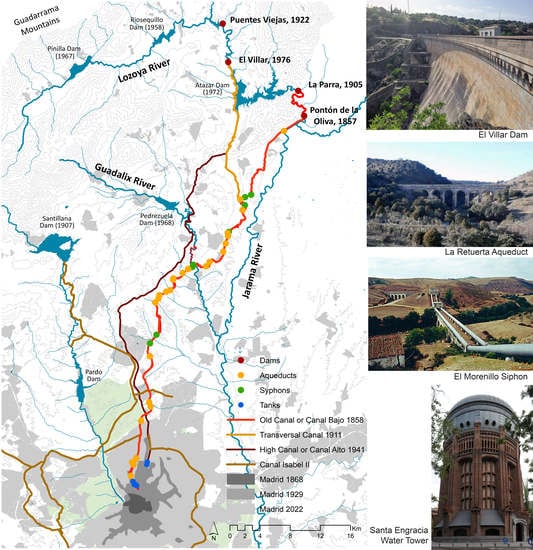
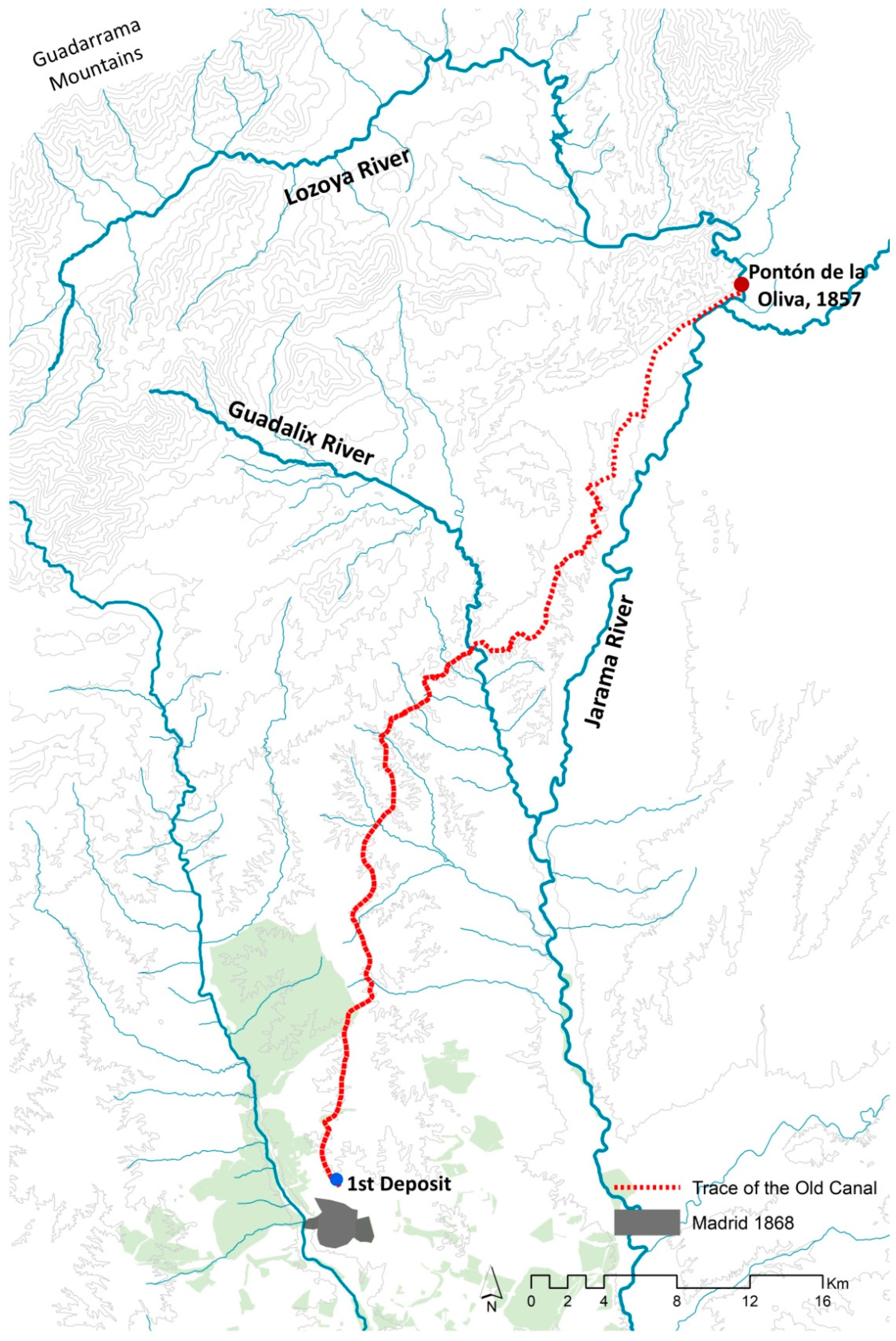
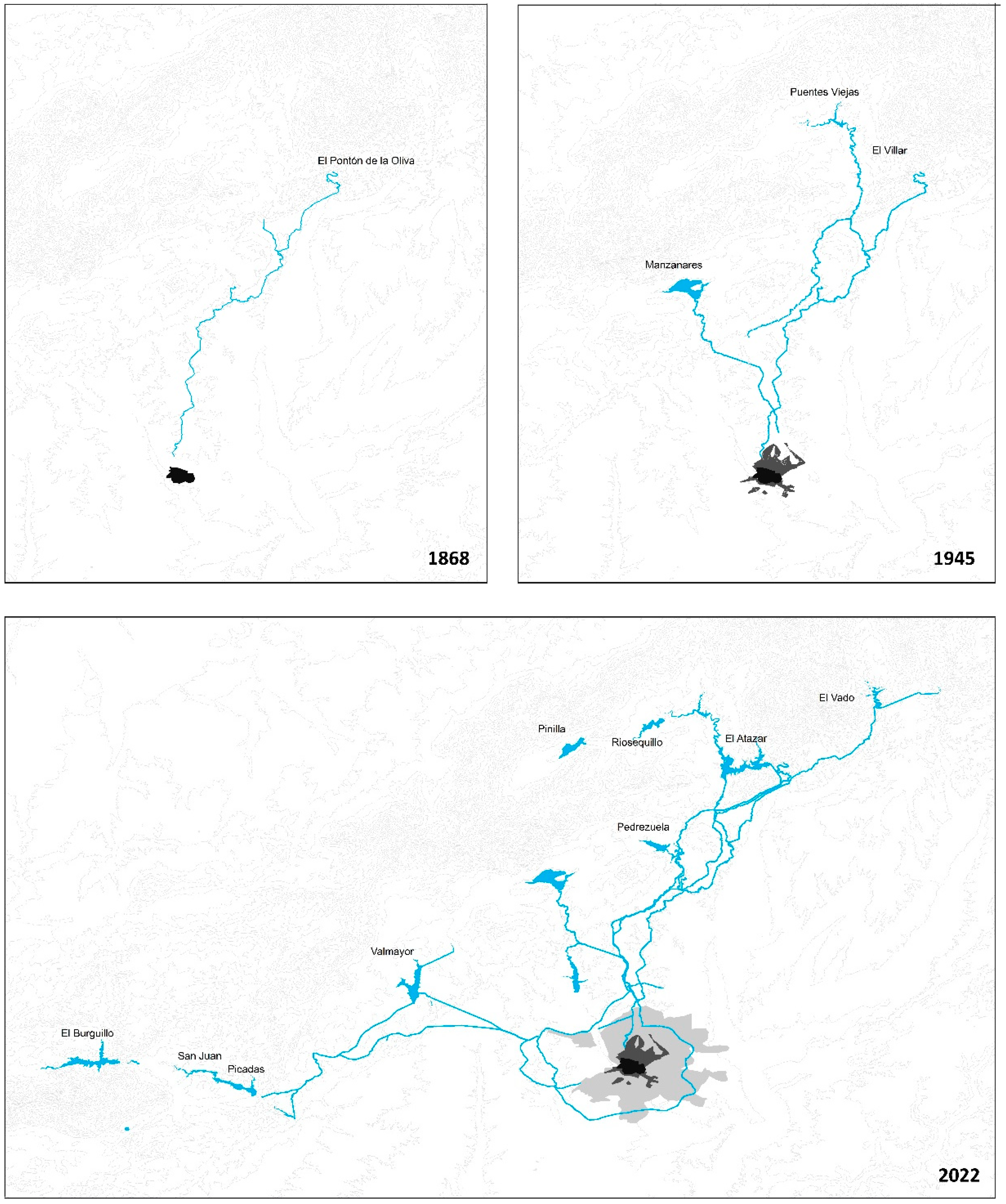
2.1. Historic Construction

In around 1850, Madrid was still supplied with drinking water through the same system that had been in use since the 16th century. There were 77 public water fountains within the urban perimeter, plus around 1000 water carriers. It is estimated that the amount of water supplied would have ranged between 2000–2500 m3 per day for a population of about 235,000 [36] (p. 27). In other words, there were between 50 and 100 litres available per person per day. The projected urban growth was also notable, as can be seen in the approval of the project for the urban development of Madrid before the end of the decade in 1857.
Under the reign of Isabel II and the government of Bravo Murillo, a water supply project was undertaken for Madrid. It was first decided that water would be brought down from the Guadalix and Lozoya rivers due to the purity of their waters. After several different proposals, in 1848, the project put forward by Rafo and Ribera was accepted. After the appointment of a team of engineers (José Garcia Otero, Lucio del Valle, Juan de Ribera and Eugenio Barron), in 1851, work started on a new dam over the bridge called Pontón de la Oliva (Figure 2) and the dam built by Cabarrús (1775) for an irrigation canal linking the Lozoya and Jarama river basins.
At the same time, construction work began on the canal and storage tanks in the city itself (Figure 3). When mapping out the routes, it was decided to build large infrastructures in order to shorten the length of the system. In other words, instead of following the curvature of the landscape, it was decided to transport the water as directly as possible (Figure 3), meaning the construction of tunnels, aqueducts, siphons, etc., to bridge valleys and ravines. Irrigation canals, siphons, regulating tanks and related constructions were built up into this network, at the same time becoming milestones across the Sierra Madrileña.
Work was complicated and full of ups and downs, not just because of the socio-economic context (lack of income, scarcity of resources, non-specialist manpower, illness, etc.) but also because it was a considerable engineering challenge at the time, without the precedent of similar projects. Cities all around the world (Washington, New York, Manchester, Paris, Lisbon, etc.) were all facing the same problem: how to create a water supply that could allow for population growth.
In addition, there were issues with seepage through the limestone on which the El Pontón de la Oliva dam was located, which meant that the water was not rising high enough to reach the entrance to the canal [37] (p. 113). A provisional connection from the Guadalix river was put in place with a new aqueduct, which eventually became permanent. At the same time, the Azud de Navarejos diversionary dam was built upstream of the Pontón de la Oliva to act as the new connection to the head of the canal.
With a total length of 70 km, made up of 29 bridges/aqueducts, 4 siphons and 41 shafts, on 24 June 1858, the Canal Bajo was officially opened by the Queen. The new water supply started to transform the city with decorative fountains in the streets, plazas and gardens, improving not only hygiene but also people’s way of life.
Due to the increased demand for water, low pressure in some areas and the poor functioning of the Pontón dam due to water seepage, Canal de Isabel II ordered the construction of a new dam further upstream in a narrow gorge around 50 metres below an old bridge called El Villar.
Although water flow increased with the new dam, the issue of murky water for several days a year continued, and so work began on the transverse canal or Canal del Villar (22 km), which entered into service in 1911. This 22-km canal ran from the Villar dam and joined the Canal Bajo at the Aldehuela aqueduct, taking out of service the older stretch of the canal running from the La Parra dam to the aqueduct. Taking advantage of the difference in altitude (150 m) between the start and the end of this new stretch, the Torrelaguna hydroelectric plant was built.
To completely resolve the murky water issue, the Puentes Viejas dam was built (1914–1929) upstream of El Villar, which used sedimentation to clean the water before it was transferred to the first dam.
In 1921, an extension was proposed for the transversal canal with what was known as the Canal Nuevo (1929–1945). This was built almost entirely underground and ends at the storage tanks in Chamartín (Figure 4).

2.2. System Components

It is important to understand the canal as a whole: its material and functional components (layout, structures, materials, etc.) are not isolated and unrelated elements, but rather, they make up a network that is not always visible, which can prevent it from being perceived in this way.
The combination of all of these components is what makes the water supply work and, at the same time, is a reflection of the history of Madrid, which would not be the same without its water. These components include dams (Figure 5), bridges/aqueducts (Figure 6), storage tanks (Figure 7) and siphons (Figure 8).
Twenty-nine narrow aqueducts were built, combining structural elegance with savings in construction material [37] (p. 67). In the higher sections of the system, they are masonry-built using local stone, while in lower sections, they are constructed in brickwork, only using masonry for angles and edges.
The canal project is important because it overlaps with the long tradition of structures of this kind built in Spain: Roman aqueducts such as those in Tarragona (Las Ferreras), Segovia or the whole of Mérida [38] had continuity over the centuries in constructions such as the Morella aqueduct (13th century) [39], the Arcos de San Antón in Plasencia (16th century) [40], the Seventeen Arcs in Lorca (18th century) [41] or the Arroyo Quintana aqueduct, part of the San Telmo water pipeline in Malaga (18th century) [42]; this list continued into the 20th century, and Eduardo Torroja designed some notable constructions, such as Tempul in Jerez de la Frontera (1925) or Alloz in Navarra (1939), which were ground-breaking in their typological concept thanks to the use of new materials [43].
The aqueduct also links us to countries of the Mediterranean environment, such as Italy, which to its collection of Roman aqueducts would add others in the Modern Age, such as those of Eleuterio in Palermo (1443) or Bigini in Castelvetrano (16th century) [44], or Portugal, with the 16th-century aqueducts Água da Prata in Évora and Amoreira in Elvas [45]. Similarly, the bridge aqueduct technology would also spread to America and, in particular, to present-day Mexico, where major works were undertaken in the 16th century, such as the Padre Tembleque Aqueduct crossing the Tepeyahualco ravine, a magnificent hybrid of European and pre-Hispanic technology [46], or the aqueduct in Valladolid, today renamed Morelia [47]. In other words, bridge aqueducts in the canal’s system are links in a triple chain connecting the land where they are located with the constructive history of Spain, with the Mediterranean basin and with colonial America. In short, we note that all of the aqueducts mentioned are still standing today, and they are core parts of the landscape; some have even been declared World Heritage Sites, such as Padre Tembleque, Segovia, Elvas, Tarragona or Mérida.
The Roman-inspired underground storage tanks are formed by archwork with barrel vaults and brick pillars built on masonry plinths. The first tank (Primer Depósito) also presented seepage problems and was therefore closed in 1894, when the second and third tanks were opened. A project for three water towers was drawn up for the supply of areas on higher ground; only the one in Calle Santa Engracia was built [37] (p. 208). The structure had a central elevator mechanism designed by Ramon de Aquinaga, which raised the water to a tank 36 metres above the ground (Figure 7).
Siphons are also an interesting part of the project (Figure 8). Although they have been used since ancient times, the ceramic material that limited diameters and advanced knowledge of the hydraulic principles required made it more common to opt for the construction of aqueducts. For the Canal de Isabel II project, cast iron was chosen as the material for the siphons. At the time, they were considered some of the most notable examples: Bodonal, Malacuero or Guadalix [1] (Table 2).

2.3. Water Management for Water Supply

Water management policies are indissolubly associated with the construction of water supply public works. They are at the base of their promotion, construction, regulation and exploitation. The management model determines the growth of the city and the sociocultural signification of water. This section identifies the turning points in water management that have influenced urban development.
At the beginning, Canal de Isabel II was a public company run by a Board made up of State representatives, the City Council and a small group of stakeholders. However, in 1868, it became a public company, reporting to the Ministry of Public Works and Transport. It was not until hydropower arrived in the region and the private company Hidráulica Santillana was constituted that this management scheme changed. Hidráulica Santillana opened the Colmenar hydraulic plant in 1902 and obtained a royal concession to supply water to the northern areas of the city, supported by the City Council, in 1906 [48] (p. 20). These two events created a conflictive situation due to the competitiveness that forced an administrative reorganisation of the company in 1907. CYII became an independent organisation using an industrial business model, still reporting to the Ministry of Public Works [49] (p. 214). It was at this point that CYII initiated the modernisation of its infrastructures and its organisation [50] (p. 483). In 1976, it became a public limited company with its own assets and independent management, reporting to the Ministry of Public Works and Transport until 1984, at which point it started reporting to the regional government, the Comunidad Autónoma de Madrid.
The crucial turning point came in 2002 when its objectives and the composition of its management board were amended by law. Since then, CYII has had permission to provide services outside the Comunidad Autónoma de Madrid and may carry out any kind of commercial or industrial activity directly related to its functions, including taking a minority or majority shareholding in companies with the permission of the regional government [51] (p. 144). In this way, CYII and the city of Madrid can form part of the virtual network system that runs new international-scale economic processes. This new concept of CYII as a multinational company widens its geographical influence, making it difficult to describe [52].
A Regional Government Act in 2008 went one step further with this idea of the liberalisation and extension of the influence of CYII: it permitted the creation of a public limited company for the provision of services relating to water and allowed the privatisation of 49% of shares. In June 2012, the new company “Canal de Isabel II Gestión, S.A.” was created, completely separate from the original CYII, which remains a regulation body. Canal de Isabel II Gestión, S.A took over the operation of water supply, sanitation and hydraulic works for the next 50 years. Even though today, over 80% of its shares are held by CYII and the rest are held by local authorities [53], there is still tension between the people and the regional government. A hydraulic technique has replaced water culture in Madrid, as happened in the 19th century when Canal de Isabel II was created [49] (p. 208).

3. Results

3.1. Value of the Overall System

As a work of engineering, Canal de Isabel II was a fundamental part of the development and modernisation of Madrid. However, it is not only functional; as heritage, it also “contains knowledge of the past with specific present uses” [54]. Its management should be analysed from a functional point of view not only as a water resource but also as a cultural resource.
The difficulty in valuing the heritage of this kind of linear hydraulic work is that it is not always visible. Through individual structures (aqueducts, siphons, irrigation canals, water tanks, etc.) (Figure 9), its value as a whole or as a system must be understood insofar as these components are part of the greater network. They cannot be understood in isolation but only as part of a system, a network with great historic, technical and cultural value. Although some elements of the canal no longer form part of the system in functional terms, they must still be perceived as an integral part of it. It is important to stress the transformative power of this entire network on the landscape.
In addition to its value as a system, the canal and its different components also have other heritage values:
  • Historic: It is proof of a significant activity from history, the bringing of water to supply the people of Madrid.
  • Technological: The canal has played a role in the evolution of engineering and in significant elements such as the design of dams, aqueduct design, pump technology, etc. These are technical milestones and technological challenges overcome from the double perspective of typology and the construction process, bearing in mind their innovative nature. They have the capacity to adapt to different uses over time while maintaining their original character.
  • Social or identity: The utilitarian purpose (value of use) tends to prevail over cultural value, as this is a large infrastructure for the service of the population (allowing the elimination of diseases transmitted in water, improved comfort, etc.) and has made a positive economic contribution (allowing urban and geographical growth, industrial development, etc.). However, it also has a strong presence in our society and culture (literature, songs, films, stamps, folklore, etc.). The canal has become a cultural reference in collective memory. It can evoke and stage and establish links to the viewer. It has taken on a symbolic character.
  • Singularity: From a technical point of view, these are integral and authentic structures (not imitations). Some of the elements are singular typologies or are first examples of other more common structures. The canal is also unique from the perspective of the historic moment, as it set a precedent for the construction of later systems.
  • Aesthetic, landscape and environmental: Its linear nature creates networks that transform the landscape on both urban and geographical scales, giving it unity through its structures, materials, etc.
Canal de Isabel II, as a public company reporting to the Ministry of Public Works and Transport since 1977 [55] (p. 138), not only is the authority in terms of water/water resources but, through its Foundation, seeks to provide know-how in innovation, bring the environment and culture closer to citizens and also promote taking care of water resources [56].
Canal de Isabel II, as a piece of cultural heritage, is included under the National Industrial Heritage Plan, which defines heritage as “an integral whole including the landscape in which the different components that make it up” “are included and related” (covering its declaration as a Bien de Interés Cultural).

3.2. New Values and New Uses

Water supply systems often maintain the utilitarian function for which they were created, subject to ongoing transformations and extensions in order to cover the growing demand for water by the urban population. However, as Sáenz de Ruidrejo claimed, changes for multiple uses over time are a typical feature of large public works that often far exceed the expectations of their creators [57] (p. 27). In this way, some of the components of Canal de Isabel II are no longer used as originally intended and yet, at the same time, have acquired new uses and values, remaining part of the overall system (Table 3).
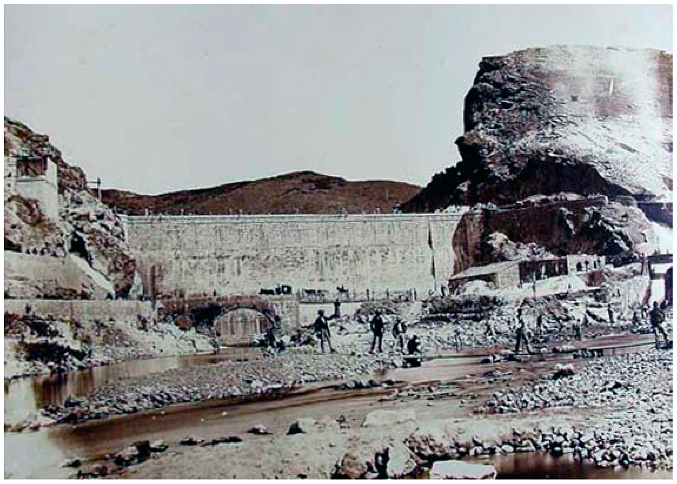
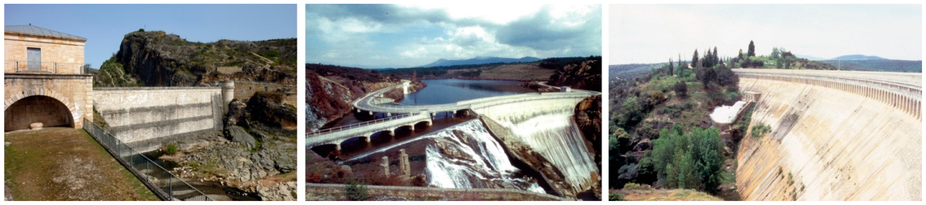
  • Pontón de la Oliva dam. Although it no longer performs the function for which it was built, the dam remains standing and is part of the historic heritage of the Ayllón mountain range. The mountain wall on the left bank of the dam is used by climbing enthusiasts. The dam is also part of a popular trekking route.
  • Recreational area at Riosequillo. Located on the right bank of the Riosequillo reservoir is one of the largest swimming pools in the Madrid region, with a capacity of more than 2000 people. It is operated by the town hall of Buitrago de Lozoya.
  • Cervera Marina. Located on the El Atazar reservoir, this recreational area is the only nautical base in the region of Madrid. It is home to an adapted sailing school, and people can practice windsurfing and rowing, as well as rent berths.
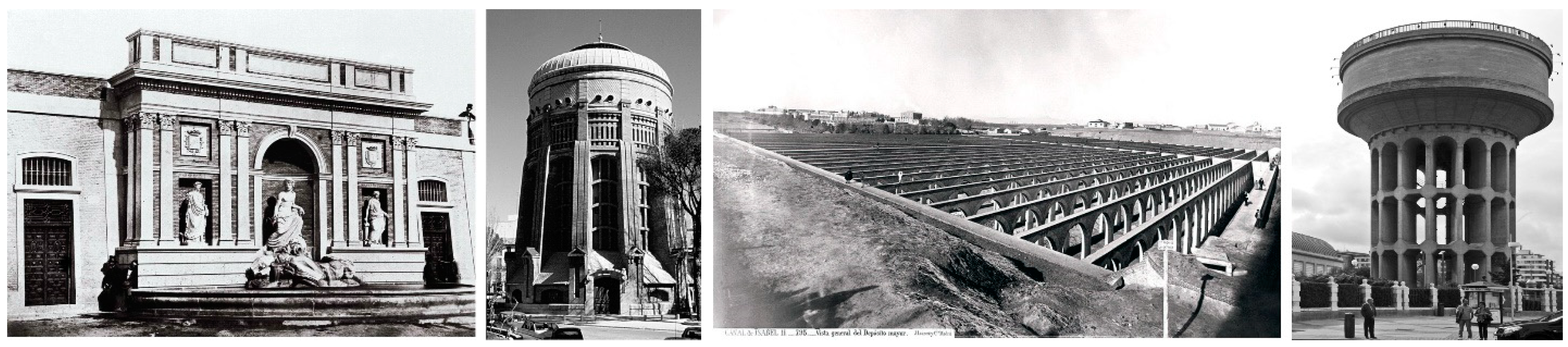
  • First underground tank at Campo de Guardias (1858). It was converted into an archive (1990) and then provisionally into an exhibition hall (2001).
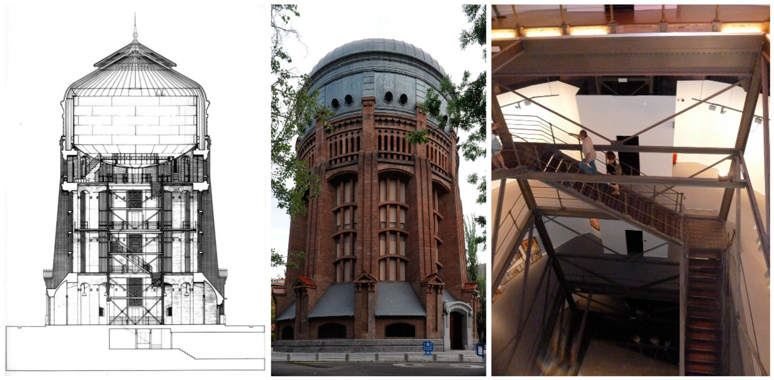
  • Second tank, or the first water tower in Santa Engracia (1907) with a capacity of 1500 m3. It was taken out of service in 1952 and reopened as an exhibition in 1985, maintaining its unique character (Figure 10).
  • Third tank (J.E. Ribera, 1915) converted into the Santander Park (2007). The tank was waterproofed, and the pillars and archwork were reinforced to build a large park with sport and leisure facilities on the roof (80,000 m2) of the tank still in use (capacity 500,000 m3).
  • Fourth tank in Plaza de Castilla or second water tower (1935) with a tank capacity of 3800 m3. One of the underground tanks was converted into an exhibition hall in 2000, maintaining its special and characteristic layout of 1447.5 m high brick arches (2500 m2); a park has been created over the roof of the structure (45,000 m2).
All of these new uses are managed differently, but always through the Canal de Isabel II Foundation.
All of these elements making up Canal de Isabel II, both those still in use as originally intended and those that have been adapted for other uses, are key parts of the collective memory and of the conservation and recovery of the urban landscape. They constitute an immense heritage to be rehabilitated and reused, with great potential for the socio-economic and cultural development of the areas where they are located. These new actions must always seek to maintain the character of the canal as key testimony to understanding and documenting this great work of engineering in the city of Madrid.
Nevertheless, as the infrastructure is still in use, some clashes arise with new uses, such as water quality problems due to recreational activities or overuse, the deterioration of vegetation and the environment, the surrounding area with the opening of new paths or routes, etc. In order to avoid this, a balance must be found between the different parts of the system and the new uses, with the new activities having virtually zero effects on the canal and its geography.

4. Discussion

The landscape is the sum of the many dialogues between people and the land, adding layer after layer to make up our current reality. These layers are the images of that territory, which humans have collected throughout their existence, and they blend together into the mental image—the landscape—that humans have of that land [58] (Lynch said that “the landscape serves as a vast mnemonic system for the retention of group history and ideals” [59], p. 126). Furthermore, a phrase from Waterman (humans have always left their mark on the landscape, such as the first cave paintings or the “great feats of engineering such as Stonehenge” [60], p. 15) shows that not all layers of the landscape have the same depth or weight. Without a doubt, certain public works are major protagonists of the character of the landscape and therefore make a distinctive mark on it [61,62]; Canal de Isabel II is the protagonist of the territory where it is located because its “layer” overshadows other man-made or natural elements present along its path; it can therefore be considered the cultural landscape of engineering.
With this idea in mind, three types of cultural landscapes of engineering can be distinguished: one or more elements in an urban location; a singular isolated work or one in a rural environment; and a set of interrelated elements with common characteristics, located across a large geographical area. Given that it is a work comprising a set of singular elements, Canal de Isabel II falls under the third category and should therefore be protected and managed on a territorial scale, integrating the whole environment [63].
Similarly, in recent times, there has been an increase in a new way of integrating into the landscape and perceiving it from within, as a part of it. One example of this is the spread of new viewpoints or observation sites appearing across the landscape, which demonstrates the need to relate to places [64]. A work of engineering can therefore be a special place for looking out over the landscape. There are notable examples of this reality in geographical routes established in recent years, associated with linear public works: within Spain, the Caminito del Rey [65], the Canal de Castilla [66] or the numerous green routes [67,68].
Indeed, tourism is an attractive option for the valuation of these heritage sites with such a historic background. We believe that aqueducts and visitable civil works should be considered places with the potential for receiving visitors interested in the history of engineering techniques or old structures. As pointed out by Medina Lasansky: “Everything, from historical monuments to exotic holiday destinations has been redesigned and packaged up for tourist consumption.” “As a result we now have a new conceptualisation of the history of specific buildings, spaces and places” [69].
Regarding the tourist use—but not exclusively linked to it—it is worth referring to the assumption that the space crossed by the canal is a cultural landscape of engineering. Just as Aldo Rossi said that architecture is a place, an event and a symbol all at the same time [70] (p. 7), we can apply the idea to large engineering works and attribute to the entire system the idea of a single place, as well as that of the technical symbol of a specific moment in time and, therefore, an event.
To conclude, it is essential to ensure the cultural preservation of public works. It should be remembered that, despite its monumental features, in the mid-20th century—and after the first declarations of historical and artistic monuments in Spain, dating from 1844, after the protection of the Segovia Aqueduct in 1884 and the Tarragona Aqueduct in 1905, and after Riegl published The Modern Cult of Monuments in 1903—in around 1915, the 16th-century Los Pilares aqueduct in Oviedo, with 41 arches and 3190 m in length, was partially pulled down to widen the bay of tracks for the railway station. Only five lonely arches remain in an uneventful area of the town. This, and other cases—such as the Eiffel bridge over the Tagus, recognised at the time as one of its 10 best bridges [71], yet demolished in 1932—must alert us to the risk posed to public works, which is always difficult to protect from an administrative point of view once they fall into disuse.
The greatest enemy of public works is ignorance of their existence, in conjunction with open-air deterioration due to natural causes: sun, frost, wind, rain and biological activity [72,73]. Registration, conservation and rehabilitation are necessary for the preservation of these works, but their recognition as heritage must be based on the significance of public works as a cultural value. The conservation of heritage must be supported by a system of protection that allows for renovation. As we have seen, one of the greatest threats to public works is obsolescence. For this reason, the best approach is one that deals not only with the conservation and repair of works but also—fundamentally—with their adaptation and rehabilitation for new uses.
In the case of historic supply systems, it is essential to understand these works as a whole, not just as individual components but rather as pieces of a network. This is also essential for the management and preservation of the canal, both where the structures are still in use as part of the water supply and where they have been converted for other uses.

5. Conclusions

In this work, the case of the Canal de Isabel II water supply to Madrid was used to analyse how these public works, which maintain their original purpose, have also taken on new uses through the conversion of some of their parts, added new values to the existing ones and positioned the infrastructure as a landmark. The main features of the original project are described in the Section 2, including the administrative and technical contexts, or the main constructions (dams, tunnels, aqueducts, siphons, etc.), and the importance of considering the water supply as a whole unit and not as a group of isolated elements is highlighted. Moreover, the relevance of aqueducts in the history of water supply projects from Roman times to the 20th century in Spain and the tradition of aqueduct construction in western Mediterranean countries or in Spanish America is underlined to understand the cultural relevance linked to this kind of public work in its geographical context. Additionally, the evolution of the water management model from the origin of the CYII to today is described.
The results establish the significance of the overall system, not only in functional terms but also as a cultural resource. Thus, several heritage values are stated: historic, technological, social or identity reference, singularity, aesthetic, landscape and environmental. These characteristics make the canal a relevant item in terms of historic, cultural and social significance, especially given the almost total absence of the heritage of the modern water industry in the UNESCO World Heritage List.
Another key point of the research is the knowledge of the new uses given to some elements of the water supply scheme. Thus, some of the components currently out of service, such as the Pontón de la Oliva dam or some old tanks, hold new uses linked to the cultural sector; however, Canal de Isabel II still manages them through its Foundation. This administrative solution, which is uncommon, allows the canal to continue its history as a singular and vast individual element regarding its unit.
Overall, the main finding of the research is the relevance of the whole water supply system. This fact is decisive not only in the use and management of the infrastructure, in which each element is part of the system, but also in the enhancement of its heritage value and in its eventual transformation. Its consideration should not be limited to the individual element but extend to the overall network. It is essential to maintain the potential of the whole in its use, management, reconversion and heritage value.
As future lines of research, we would like to point out two lines of interest. On the one hand, the study methodology and valuation proposal can be applied to other public works that also have an important territorial extension and historical value and use, for example, roads, railways or ports. In addition to their linear development in the territory or along the coast, they also have similarities to water supply systems in their important territorial identity and to the historical evolution of the cities. Finally, the analysis of tourist opportunities as social and cultural activators is a line with great potential. Again, it will be essential to maintain the overall character of public works in their heritage appreciation.

Author Contributions

Conceptualisation, J.B.-L. and P.P.-L.; methodology, B.C.-A. and P.H.-L.; research, J.B.-L., B.C.-A. and P.H.-L.; data curation, B.C.-A. and P.H.-L.; writing—original draft preparation, P.P.-L. and P.H.-L.; writing—review and editing, J.B.-L. and B.C.-A.; visualisation, B.C.-A.; supervision and project administration, P.H.-L. All authors have read and agreed to the published version of the manuscript.

Funding

This research was funded by Ministerio de Ciencia, Innovación y Universidades, Gobierno de España. Proyectos I + D+i, 2020–2022, (PID2019-105877RA-I00). Análisis y definición de estrategias para la caracterización, recuperación y puesta en valor del patrimonio de las obras públicas. Una aproximación desde la escala territorial. Coordinator: Rita Ruiz, Universidad de Castilla La Mancha.

Institutional Review Board Statement

Not applicable.

Informed Consent Statement

Not applicable.

Conflicts of Interest

The authors declare no conflict of interest. The funders had no role in the design of the study; in the collection, analyses or interpretation of data; in the writing of the manuscript; or in the decision to publish the results.

References

  1. Hernández Lamas, P.; Cabau Anchuelo, B.; de Castro Cuartero, O.; Bernabéu Larena, J. Mobile Applications, Geolocation and Information Technologies for the Study and Communication of the Heritage Value of Public Works. Sustainability 2021, 13, 2083. [Google Scholar] [CrossRef]
  2. Editorial Office. Acueducto de Jerez. Rev. Obras Públicas 1865, 13, 166–171. [Google Scholar]
  3. Pardo, M. Abastecimiento de aguas del Puerto de Santa María. Rev. Obras Públicas 1878, 26, 111–114. [Google Scholar]
  4. Barron, E. Conducción de agua a Santander. Rev. Obras Públicas 1878, 28, 2–5. [Google Scholar]
  5. Borregón López-Peñalver, A. Abastecimiento provisional de aguas en Valladolid. Rev. Obras Públicas 1880, 28, 2–5. [Google Scholar]
  6. Plasencia-Lozano, P. El Proyecto de Abastecimiento de Cáceres realizado por García Faria en 1895. Rev. Obras Públicas 2011, 158, 55–62. [Google Scholar]
  7. Merdinger, C.J. Water supply through the Ages: Part I. Early History. Mil. Eng. 1955, 318, 280–285. [Google Scholar]
  8. Houghton, J. Abastecimiento de aguas en varias poblaciones de los Estados Unidos. Rev. Obras Públicas 1855, 3, 225–226. [Google Scholar]
  9. Editorial Office. Consumo de agua de Nueva York. Rev. Obras Públicas 1876, 24, 74. [Google Scholar]
  10. Editorial Office. Abastecimiento de aguas para grandes poblaciones. Rev. Obras Públicas 1899, 46, 459–460. [Google Scholar]
  11. Del Valle Arana, L. Abastecimiento de agua en Lisboa. Rev. Obras Públicas 1856, 4, 133–136. [Google Scholar]
  12. Editorial Office. Nota sobre la distribución de las aguas de Berlín. Rev. Obras Públicas 1857, 5, 124–127. [Google Scholar]
  13. Churruca Brunet, E. Abastecimiento de aguas de Chicago. Rev. Obras Públicas 1874, 22, 109–116. [Google Scholar]
  14. Monterde, A. Consumo de agua en las grandes poblaciones. Rev. Obras Públicas 1863, 11, 87–88. [Google Scholar]
  15. Blasco Esquivias, B. Toledo y Madrid: Sistemas de captación y uso del agua para servicio doméstico en la Edad Moderna. In Patrimonio Cultural Vinculado con el Agua. Paisaje, Urbanismo, Arte, Ingeniería y Turismo; Editora Regional de Extremadura: Mérida, Mexico, 2014; pp. 267–279. [Google Scholar]
  16. Melosi, M.V. Precious Commodity: Providing Water for America’s Cities; University of Pittsburgh Press: Pittsburgh, PA, USA, 2011. [Google Scholar]
  17. Hassan, F. Water, History for Our Times. IHP Essays on Water History; UNESCO: Paris, France, 2011; Volume 2. [Google Scholar]
  18. Blake, N.M. Water for the Cities: A History of the Urban Water Supply Problem in the United States; University Microfilm International: Ann Arbor, MI, USA, 1995. [Google Scholar]
  19. Angelakis, A.; Zheng, X.Y. Evolution of water supply, sanitation, wastewater, and stormwater technologies globally. Water 2015, 7, 455–463. [Google Scholar] [CrossRef] [Green Version]
  20. Vilar, D.D.; Fonseca, F.P. The waters of Cantareira: The hydraulic heritage of the city of Sao Paolo. In Hydraulic Heritage in Ibero-America; Francisco da Silva, C., Vieira, A., José Manuel Lopes, C., Jesus, N.-G., Eds.; Nova Science Publisher: Hauppauge, NY, USA, 2020; pp. 127–158. [Google Scholar]
  21. Billington, D.P.; Jackson, D.C.; Melosi, M.V. The History of Large Federal Dams: Planning, Design and Construction in the Era of Big Dams; US Department of the Interior, Bureau of Reclamations: Washington, DC, USA, 2005.
  22. Jackson, D.C. Dams; Routledge: Oxfordshire, UK; Taylor & Francis Group: Abingdon, UK, 1998. [Google Scholar]
  23. Astwood, K.; Fell, G. Karoki Water Supply Dams and Reservoirs; Engineering Heritage New Zealand: Wellington, New Zealand, 2012. [Google Scholar]
  24. Douet, J. Temples of Steam. Waterworks Architecture in the Steam Age; Bristol Polytechnic: Bristol, UK, 1992. [Google Scholar]
  25. Vonka, M.; Kořinek, R. Chimney Reservoirs: Unique Technical Structures from the first half of the 20th century in the Czech Republic. Acta Polytech. 2018, 58, 155–164. [Google Scholar] [CrossRef] [Green Version]
  26. Bandrés Mariscal, C.; Robador González, M.D.; Albardonedo Freire, A. Analysis and structure of water distribution system in the distribution depot of the Carmona Gate as a way of supplying water to the Royal Alcazar of Seville. In Conserving Cultural Heritage, Proceedings of the 3rd International Congress on Science and Technology for the Conservation of Cultural Heritage, Cádiz, Spain, 21–24 May 2017; Mosquera, M., Almoraima, M.L., Eds.; Taylor & Francis Group: Oxfordshire, UK, 2018; pp. 209–212. [Google Scholar]
  27. Koeppel, G. Water for Gotham: A History; Princeton University Press: Princeton, NJ, USA, 2001. [Google Scholar]
  28. Baker, M.N.; Taras, M. The Quest for Pure Water: The History of Water Purification from the Earliest Records to the Twentieth Century; American Water Works Association: Denver, CO, USA, 1981. [Google Scholar]
  29. Şener, İ. Assessment of Izmir Halkapinar Water Pump Station for Its Conservation as Industrial Heritage. Ph.D. Thesis, School of Engineering and Sciences of Izmir Institute of Technology, Izmir, Turkey, 2019. [Google Scholar]
  30. Voudouris, K.; Valipour, M.; Kaiafa, A.; Zheng, X.Y.; Kumar, R.; Zanier, K.; Kolokytha, E.; Angelakis, A. Evolution of water wells focusing on Balkan and Asian civilizations. Water Supply 2019, 19, 347–364. [Google Scholar] [CrossRef]
  31. Ursino, N.; Pozzato, L. Heritage-Based Water Harvesting Solutions. Water 2019, 11, 924. [Google Scholar] [CrossRef] [Green Version]
  32. Douet, J. The Water Industry as World Heritage; TICCIH Thematic Paper; 2018; Available online: https://ticcih.org/wp-content/uploads/2018/05/TICCIH-Water-Report.pdf (accessed on 16 May 2022).
  33. Hunter Burkett, M. Silent and Unseen: Stewardship of Water Infraestructural Heritage. In Adaptative Strategies for Water Heritage. Past, Present and Future; Springer International Publishing: Berlin/Heidelberg, Germany, 2020; pp. 21–39. [Google Scholar]
  34. Blazquez Herrero, C. El Acueducto de Aguas Livres en Lisboa; Agua Ibérica: Aragon, Spain, 2019; Available online: https://www.aguaiberica.com/2019/06/18/el-acueducto-de-aguas-livres-en-lisboa/ (accessed on 15 June 2022).
  35. Ruiz, R. Coordinator. Análisis y definición de estrategias para la caracterización, recuperación y puesta en valor del patrimonio de las obras públicas. Una aproximación desde la escala territorial (PID2019-105877RA-I00). In I+D+I Project; Ministerio de Ciencia; Innovación y Universidades: Madrid, Spain, 2020–2022. [Google Scholar]
  36. Rueda Laffond, J.C. El Agua en Madrid. Datos Para Historia del Canal de Isabel II (1851–1930); Fundación Empresa Pública: Madrid, Spain, 1994. [Google Scholar]
  37. Martínez Vázquez de Parga, R. Historia del Canal de Isabel II; Fundación Canal de Isabel II: Madrid, Spain, 2001. [Google Scholar]
  38. Fernández Casado, C. Acueductos Romanos en España; Instituto Eduardo Torroja: Madrid, Spain, 1972. [Google Scholar]
  39. García Grinda, J.L. Arquitectura e ingenios hidráulicos: Orígenes y presencia medieval. Bibl. Estud. E Investig. 2009, 24, 143–168. [Google Scholar]
  40. Plasencia Lozano, P. L´acquedotto “Arcos de San Antón” di Plasencia. In Il Valore Dell’acqua nel Patrimonio dei beni Culturali Attraverso la Lettura di Alcuni Episodi Architettonici, Urbani e Territoriai. Gli Acquedotti e le Fontane a Roma dal XVI al XIX Secolo; Aracne: Roma, Italy, 2014; pp. 203–218. [Google Scholar]
  41. Pelegrín Garrido, M.C. Obras hidráulicas históricas de Lorca. Alberca 2006, 4, 165–171. [Google Scholar]
  42. Camacho Martínez, R. Los problemas del agua en Málaga en el siglo XVIII: El Acueducto de San Telmo y su valoración actual. In Paisajes Modelados por el Agua: Entre el Arte y la Ingeniería; Editora Regional de Extremadura: Mérida, Spain, 2012; pp. 41–61. [Google Scholar]
  43. Torroja, E. Acueducto de Alloz. Inf. Construcción 1962, 14, 134–148. [Google Scholar] [CrossRef] [Green Version]
  44. Nobile, M.R. Fontane e acquedotti nella Sicilia tra XV e XVII secolo. In Patrimonio Cultural Vinculado con el Agua. Paisaje, Urbanismo, Arte, Ingeniería y Turismo; Editora Regional de Extremadura: Mérida, Spain, 2014. [Google Scholar]
  45. Trindale, L. A água nas cidades portugueseas entre os séculos XIV e XVI. In Patrimonio Cultural Vinculado con el Agua. Paisaje, Urbanismo, Arte, Ingeniería y Turismo; Editora Regional de Extremadura: Mérida, Spain, 2014; pp. 367–380. [Google Scholar]
  46. de Jesús Martínez Pelcastre, E. Herencia constructiva en la fábrica de acueductos novohispanos en el siglo XVI en el estado de Hidalgo. In Tercer Congreso Internacional Hispanoamericano de Historia de la Construcción; Instituto Juan de Herrera: Madrid, Spain, 2019; pp. 319–330. [Google Scholar]
  47. Cabrera Aceves, J. El acueducto histórico de Valladolid, hoy Morelia, México. Nuevos acercamientos a su función hidráulica y estereotomía. In Proceedings of the Noveno Congreso Nacional y Primer Congreso Internacional Hispanoamericano de Historia de la Construcción, Segovia, Spain, 13–17 October 2015; pp. 289–299. [Google Scholar]
  48. Sánchez de Toca, J. Juicio del Sr. Sánchez de Toca. Rev. Obras Públicas 1925, Tomo I, 20–23. [Google Scholar]
  49. Gavira, C. De la cultura del agua a la técnica hidráulica: El canal de Isabel II. In Ciudad, Territorio y Patrimonio. Materiales de Investigación; Castrillo Romón, M., Ed.; Instituto Universitario de Urbanística: Valladolid, Spain, 2000. [Google Scholar]
  50. de Isabel, C., II. Plan de obras para mejorar y completar el abastecimiento de aguas de Madrid. Rev. Obras Públicas 1907, Tomo I, 483–487. [Google Scholar]
  51. Ortega de Miguel, E.; Sanz Mulas, A. A public sector multinational company: The case of Canal de Isabel II. Util. Policy 2007, 15, 143–150. [Google Scholar] [CrossRef]
  52. Rubio Gavilán, A.; Hernández Lamas, P.; Bernabéu Larena, J. Water Supplies build the cities: The Canal de Isabel II as origin of the metropolis if Madrid. In Back to the Sense of the City, Proceedings of the 11th International Congress Virtual Cities and Territories, 6–8 July 2016; 11 VCT.; Institute of Urban Design, Faculty of Architecture, Cracow University of Technology: Kraków, Poland, 2016. [Google Scholar]
  53. Marcos, J. El Canal, Que Aguirre Quería Privatizar, Ganó 225 Millones en 2014 El Pais (Madrid). Available online: http://ccaa.elpais.com/ccaa/2015/06/20/madrid/1434822230_248284.html (accessed on 21 June 2021).
  54. Harvey, D.C. Heritage Past and Heritage Presents: Temporality, meaning and the scope of heritage studies. Int. J. Herit. Stud. 2001, 7, 319–338. [Google Scholar] [CrossRef]
  55. Aguiló Alonso, M. El Agua en Madrid; Diputación de Madrid. Area de Urbanismo y Ordenación Territorial: Madrid, Spain, 1983. [Google Scholar]
  56. Fundación Canal. About Us. Available online: https://www.fundacioncanal.com/en/about-us/ (accessed on 24 April 2022).
  57. Sáenz Ruidrejo, F. Presentación. In Descripciones de los Canales Imperial de Aragón y Real de Tauste (1976); Ministerio de Fomento: Madrid, Spain, 1984. [Google Scholar]
  58. Plasencia Lozano, P. Apuntes sobre la relación entre la obra pública y el paisaje. Carreteras. Rev. Técnica Asoc. Española Carret. 2017, 212, 20–27. [Google Scholar]
  59. Lynch, K. The Image of the City; The MIT Press: Cambridge, UK, 1960. [Google Scholar]
  60. Waterman, T. Principios Básicos de la Arquitectura del Paisaje; Nerea: San Sebastián, Spain, 2009. [Google Scholar]
  61. Nárdiz Ortiz, C. El Paisaje en la Ingeniería; Ministerio de Fomento: Madrid, Spain, 2019. [Google Scholar]
  62. Español Echániz, I. La Carretera en el Paisaje. Criterios Para su Planificación, Trazado y Proyecto; Junta de Andalucía: Seville, Spain, 2008. [Google Scholar]
  63. Plasencia Lozano, P. Alconétar, paisaje cultural del al ingeniería. Una propuesta de ordenación territorial. In Paisajes Modelados por el Agua: Entre el Arte y la Ingeniería; Editora Regional de Extremadura: Badajoz, Spain, 2012; pp. 187–205. [Google Scholar]
  64. Plasencia Lozano, P. Miradores a la obra pública y la obra pública como mirador. In El Patrimonio de las Obras Públicas. Del Puente Romano de Alcántara al Diálogo con la Actualidad; Sial Pigmalión: Madrid, Spain, 2022; pp. 429–462. [Google Scholar]
  65. Machuca Santa Cruz, L.; Machuca Casares, B. Caminito del Rey: “el proyecto ha sido un desafio”. PH Boletín Inst. Andal. Patrim. Histórico 2016, 24, 19–21. [Google Scholar] [CrossRef]
  66. Leno Cerro, F. La evaluación de los recursos turísticos: El caso del Canal de Castilla. Treb. Geogr. 1990, 43, 135. [Google Scholar]
  67. AevvBoss. Declaración para una “Red Verde Europea”. Asociación Europea de Vías Verdes, 15-03-2016. Available online: https://www.aevv-egwa.org/es/declaracion-para-una-red-verde-europea/ (accessed on 15 May 2022).
  68. Bargón García, M.; Plasencia Lozano, P. Las vías verdes en Asturias. La reutilización de una infraestructura ferroviaria obsoleta como parques lineales urbanos y regionales. In Restauro: Temi Contemporanei per un Confronto Dialettico; Università degli Studi di Firenze: Firenze, Italy, 2020; pp. 428–437. [Google Scholar]
  69. Medina Lasansky, D. Introducción. In Arquitectura y Turismo. Percepción, Representación y Lugar; Gustavo Gili: Barcelona, Spain, 2006; pp. 15–27. [Google Scholar]
  70. Rossi, A. L´Architettura Della Città; Marsilio Editore: Padua, Italy, 1966. [Google Scholar]
  71. Plasencia Lozano, P. El puente sobre el Tajo de Eiffel en España. Inf. Construcción 2018, 70, e268. [Google Scholar] [CrossRef]
  72. Sainz-Jimenez, C.; González, J.M. Aerobiology and cultural heritage: Some reflections and future challenges. Aerobiologia 2007, 23, 89–90. [Google Scholar] [CrossRef]
  73. Sainz-Jimenez, C. Biodeterioration vs biodegradation: The role of microorganisms in the removal of pollutants deposited on historic buidlings. Int. Biodeterior. Biodegrad. 1997, 40, 225–232. [Google Scholar] [CrossRef] [Green Version]
Figure 1. Evolution of the population of Madrid: year–inhabitants. Source: Created by the authors based on data from the Spanish National Institute of Statistics, INE 2022.
Applsci 12 06731 g001
Figure 2. Construction of the Pontón de la Oliva dam, 1855. Photo: Charles Clifford. (Public domain. Biblioteca virtual del Patrimonio Bibliográfico, https://bvpb.mcu.es/es/consulta/registro.cmd?id=403102) (accessed on 15 May 2022).
Applsci 12 06731 g002
Figure 3. Ground route of the first Canal de Isabel II, 1868. Source: Created by the authors.
Applsci 12 06731 g003
Figure 4. Evolution of the water supply network and the urban nucleus of Madrid: 1868, 1945 and 2022. Source: Created by the authors.
Applsci 12 06731 g004
Figure 5. Pontón de La Oliva (1858–1860): straight solid masonry gravity-based dam and narrow-lipped spillway. Villar Dam (1869–1882) Engineers Elzeario Boix and José Morer: first curved gravity dam built worldwide with a lateral spillway system. Puentes Viejas Dam (1914–1929): curved plan gravity dam. Source: FMA.
Applsci 12 06731 g005
Figure 6. Canal Bajo Aqueducts: La Sima Aqueduct (1855), La Retuerta Aqueduct (1855) and El Espartal Aqueduct (1852). Source: FMA.
Applsci 12 06731 g006
Figure 7. Tanks: Primer Depósito-Campo de Guardias (1858), Santa Engracia water tower (1912), Tercer Depósito (1893) and Plaza de Castilla water tower (1939; relocated in 1952). Source: Charles Clifford and FMA.
Applsci 12 06731 g007
Figure 8. Siphons: Guadalix Siphon; Morenillo Siphon. Source: Clifford, 1858; FMA.
Applsci 12 06731 g008
Figure 9. Canal de Isabel II as a whole system. Source: Created by the authors.
Applsci 12 06731 g009
Figure 10. First water tank (1907) converted into exhibition hall (1985). Source: FMA.
Applsci 12 06731 g010
Table 2. Main siphons in Europe. Note the maximum load of those designed in Madrid, exceeded only by the ones in Liverpool [2].
PopulationSiphonLength (m)Maximum Load (m)Interior Diameter (m)Thickness (m)
MadridGuadalix323.5053.600.920.018
Malacuero843.0045.000.920.018
Bodonal1410.0021.000.920.018
New YorkManhattan1254.0031.500.920.018
GlasgowGlasgow3500.00251.120.19
LiverpoolAspull a Montrey13,00086.501.120.025
JerezAlbaladejo10,20080.000.610.019 and 0.025
Guadalete18,00090.000.610.019 and 0.025
Table 3. Heritage elements of the canal, types and original and current uses. Note the correspondence with Figure 9.
TypeNumberNameYearIn ServiceNew Use
Aqueducts1Cuevas1852Yes
2La Aldehuela 1852Yes
3Espartal1852Yes
4Bajada Morenillo1852Yes
5Regachuelo1855Yes
6de la Cerca de Gavino1855Yes
7Fuente del Palo1855Yes
8Valmayor1855Yes
9Barbotoso1855Yes
10Navalperal1855Yes
11Retuerta1855Yes
12Sima1855Yes
13Valcaliente1855Yes
14Colmenarejo1855Yes
15Cabeza-Cana1855Yes
16Mojapán1855Yes
17El Cerrillo1855Yes
18La Parrilla1855Yes
19Valdealeas1858Yes
20Valle de la Fuente1858Yes
21Vallegrande o Valdelatas1858Yes
22El Sotillo1858Yes
23Valdeperales 1858Disappeared
24Los Pinos1858Yes
25La Traviesa1858Yes
26Valdeacederas1858Yes
27Los Barrancos1858Yes
28La Huerta del Obispo1858Yes
29Amaniel1858Yes
Syphonss1La Malacuera1858Yes
s2Los Yesos1858Yes
s3El Morenillo1858Yes
s4Guadalix1858Yes
s5El Bodonal, Viñuelas1858Yes
Tanks1First buried tank1858–1894NoArchive, exhibitions
2Second buried tank1879YesPark
3Third buried tank1915YesPark
4First elevated tank1912–1952NoExhibitions
Dams1Pontón de la Oliva1858NoLandmark
2Navarejos1859Yes
3El Villar1882Yes
4La Parra1904Yes
5Puentes Viejas1929Yes
Publisher’s Note: MDPI stays neutral with regard to jurisdictional claims in published maps and institutional affiliations.

