Object-Based Mapping of Coral Reef Habitats Using Planet Dove Satellites


1
Center for Global Discovery and Conservation Science (GDCS), Arizona State University, Tempe, AZ 85281, USA
2
The Nature Conservancy, Caribbean Division, Coral Gables, FL 33134, USA
*
Author to whom correspondence should be addressed.
Remote Sens. 2019, 11(12), 1445; https://doi.org/10.3390/rs11121445
Submission received: 23 May 2019
/
Revised: 13 June 2019
/
Accepted: 15 June 2019
/
Published: 18 June 2019
(This article belongs to the Special Issue Earth Observation Technology Applied to Coral Reefs)
Abstract
:High spatial resolution benthic habitat information is essential for coral reef protection and coastal environmental management. Satellite-based shallow benthic composition mapping offers a more efficient approach than traditional field measurements, especially given the advancements in high spatial and temporal resolution satellite imagery. The Planet Dove satellite constellation now has more than 150 instruments in orbit that offer daily coverage at high spatial resolution (3.7 m). The Dove constellation provides regularly updated imagery that can minimize cloud in tropical oceans where dense cloud cover persists. Daily image acquisition also provides an opportunity to detect time-sensitive changes in shallow benthic habitats following coral bleaching events, storms, and other disturbances. We developed an object-based coral reef habitat mapping approach for Dove and similar multispectral satellites that provides bathymetry estimation, bottom reflectance retrieval, and object-based classification to identify different benthic compositions in shallow coastal environments. We tested our approach in three study sites in the Dominican Republic using 18 Dove images. Benthic composition classification results were validated by field measurements (overall accuracy = 82%). Bathymetry and bottom reflectance significantly contributed to identifying benthic habitat classes with similar surface reflectance. This new object-based approach can be effectively applied to map and manage coral reef habitats.
1. Introduction
Coral reefs and associated shallow coastal ecosystems are among the most productive and vulnerable in the world [1]. Effective protection and management of coral reefs rely heavily on accurate and up-to-date spatially-explicit information on shallow benthic habitats [2]. Traditional labor-intensive field surveys offer point and transect records that can only be applied to small areas [3]. While field-based methods can collect detailed information along coral reef transects, these data are often limited to very small areas and are inadequate for monitoring large areas [4]. However, satellite remote sensing technology, when combined with field survey data, provides a solution to repeatedly map and monitor coral reef benthic habitats over large geographic areas [5]. A common trade-off of remote sensing is its lower accuracy compared to field surveys.
Advances in Earth observation offer benefits to coral reef habitat mapping via higher spatial resolution (pixel sizes <5 m) and increasing temporal resolution [6]. High image acquisition frequency (e.g., daily) provides increased likelihood of obtaining cloud-free scenes over tropical regions and delivers time-sensitive data allowing detection of changes to the benthos such as large-scale coral bleaching [2,7]. In NASA MODIS image analyses, a typical portion of the cloud-free satellite images over reef regions ranges from 20% to 30% [8,9]. Previous coral reef studies have been conducted using mid-spatial resolution satellite images (e.g., Landsat-8, Sentinel-2) or high-resolution images with low temporal frequency (e.g., IKONOS, Worldview) [3,4,10,11,12,13]. Coral reef mapping could benefit from high temporal frequency satellite sensors (e.g., Planet Dove).
Mapping benthic composition in shallow coastal environments requires multiple inputs, including sea surface reflectance, bottom (or benthic) reflectance, and bathymetry to identify different habitats using either an object- or a pixel-based approach [2,14]. In particular, bathymetry information is central to identifying different benthic surfaces within distinct coastal geomorphic zones. Moreover, bottom reflectance retrieved from satellite images follows the removal of water column attenuation effects using radiative transfer modeling techniques [15]. Here, we developed a comprehensive object-based mapping approach that provides bathymetry estimation, bottom reflectance retrieval, and object-based classification, all using Planet Dove satellite images. We applied and verified our approach in three coastal sites located in the southeastern Dominican Republic using GPS-referenced underwater video and transducer bathymetry field data. We then performed an accuracy assessment analyzing different benthic habitat types and bathymetric ranges. As part of this research, we also investigated the effects that benthic habitat reflectance, bathymetry, and water column attenuation have on Dove-derived coral reef habitat products.
2. Materials and Methods
2.1. Study Sites
Three shallow coastal study sites were selected within a recently declared 8000 km2 marine sanctuary “Arrecifes del Sureste” (Latitude: ~17.5°–18.8° N, Longitude: ~67.8°–69.35° W). This sanctuary covers 120 km of coast and is a primary tourism hub, receiving over 4 million visitors annually (Figure 1). With coral reef-based tourism being a major part of the local Dominican Republic economy, a park management plan is currently being developed to monitor and protect these coastal ecosystems. We chose benthic classes to conform to those used by conservation practitioners who manage these habitats within the Dominican Republic. Our research provides an opportunity to test object-based shallow benthic composition mapping across a wide range of benthic types, geomorphic zones, and bathymetric ranges. Such products can provide baseline data, monitor changes, and inform adaptive management actions within the park.
2.2. Field Data Collection
From 30 April to 4 May 2018, a total of six field transects were generated to measure and assess a diverse array of benthic compositions within the three study sites (Catalina Island, Saona Island, and Eastern Dominican Republic, Figure 1). Bathymetric field measurements were collected using a Lowrance Elite7Ti ® (Tulsa, OK, USA) system with a xSonic P319 (50/200 kHz) transducer and 10 Hz GPS receiver that collected continuous depth readings at 3 pts/sec along each transect. In parallel, a GPS-referenced SeaViewer Sea-Drop 6000 HD (Tampa, FL, USA) underwater video camera with 30 m vertical cable was used to record benthic habitat types along each transect (Table 1). A total of 152.4 km of bathymetric measurements and 122 benthic video samples were recorded along all transects. From these data, we generated 5300 bathymetric measurement points at a 15 m interval. Benthic habitat types (coral reef crest, coral patch deep, coral back-reef/flat, coral fore-reef, gorgonian/soft coral, hardbottom with algae, seagrass dense, seagrass sparse, sand shallow, and sand deep with sparse macroalgae) were classified for each video sample (Table 1). A total of 3000 points were applied as the training samples for the object-based classification. The remaining 2300 points were used for model verification. We selected the training and verification points based on depths and habitat types.
2.3. Satellite Image Processing
Planet (formerly Planet Labs, Inc.) has manufactured and launched numerous miniature satellites called “Dove”. With a constellation of over 150 satellites, the Doves offer 3.7 m spatial resolution and collect daily scenes. A total of 18 sun-synchronous Dove images from three satellite sensors were selected to map benthic habitats over the study area. The single scene dimensions are approximately 25 km × 8 km with a spatial resolution of 3.7 m. These images were collected from 22 January to 30 January 2018 and were selected based on minimal cloud cover, sun-glint, waves, and water turbidity. The Dove top-of-atmosphere (TOA) radiance in Blue (470 nm), Green (540 nm), Red (610 nm) and Near-Infrared (NIR; 780 nm) bands were used to correct atmospheric effects by using the 6S atmospheric correction model [17]. The resulting surface reflectance in visible bands were subtracted by the NIR band in order to minimize sea surface effects to derive marine reflectance as [18]:
Below-surface remote sensing reflectance () was then calculated using method by [19]:
With below-surface reflectance calculated, water bathymetry was predicted using an adaptive bathymetry estimation method with self-tuning parameters () as described in Li et al. [20]:
Using the modeled bathymetry, we estimated bottom reflectance by using bathymetry as input information. We masked out deep open ocean according to the bathymetry (H > 15 m). The total below-surface remote sensing reflectance is the combination of both water column contribution () and bottom contribution at the water surface () as [21]:
where bottom contribution at the water surface () is contributed by bottom reflectance () as:
where k is an attenuation coefficient for the water column [19].
After deriving surface reflectance , bottom reflectance and bathymetry H, we used eCognition Developer 9.4 (Munich, Germany) software to segment the images using the following parameters: Scale (150), Shape (0.1), and Compactness (0.5). We tested different combinations of segmentation parameters (50 < Scale < 200, 0.05 < Shape < 0.2, 0.1 < Compactness < 1.0) to arrive at the combination that best captured the representation of benthic features based on the visual examination. These processing steps are illustrated in Figure 2.
The interpreted GPS-referenced video transects were used to identify objects that represented each habitat type, and the nearest neighbor classifier was applied to classify the objects. The nearest neighbor classifier was selected because it offered the best results after comparison of multiple classifiers (e.g., nearest neighbor, support vector machine, etc.). The mean values of the blue and green bands for both surface reflectance and bottom reflectance and mean depth were used as object attributes for the classifier. For shallow to medium depths (<10 m), a greater layer weight was placed on surface reflectance values, and for deeper depths (>10 m), a greater weight was placed on bottom reflectance values. The lower portions of water leaving radiance are contributed by the bottom reflectance at greater depths [19,22]. Upon completing the benthic composition classification, an accuracy assessment (confusion matrix) was conducted using the remaining field validation points.
3. Results
3.1. Bathymetry Retrieval and Benthic Composition Classification
The high-resolution bathymetry information generated from Planet Dove satellite images was consistent with known spatial variations from shallow to deep coral reef regions and out to the deep ocean. For instance, general depth trends were retrieved with an increasing depth gradient extending from land to ocean. These satellite-derived bathymetry measurements supported the mapping of benthic geomorphologic zones, such as shallow reef crest (depth <3 m), which are found along the coast of southeastern Dominican Republic (Figure 3). Comparing the mapped bathymetry to field-based water depth measurements, root mean square errors (RMSE) ranged from 1.37 m to 1.98 m, and R2 ranged from 0.70 to 0.91 (Catalina Island, RMSE = 1.98 m, R2 = 0.70; Saona Island, RMSE = 1.37 m, R2 = 0.91, east Dominican Republic, RMSE = 1.72 m, R2 = 0.73) (Figure A1a–c). The overall accuracy RMSE was 1.5 m, sufficient to support subsequent benthic classification steps. The NIR band was used to remove the water surface effect in the initial step of satellite image processing (Figure 2). Therefore, higher RMSE values at the Catalina Island study site were caused by poor image quality in the near-infrared band.
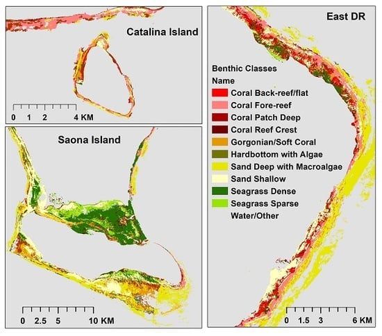
The results of the image segmentation for the three study sites are shown in Figure 4. Different benthic habitat types were segmented based on the combined inputs of surface reflectance, bottom reflectance, and bathymetry. The final derived benthic habitat maps based on the classification scheme are shown in Figure 5. This scheme was developed for coral reef management applications, which provides a baseline to compare future change, and is useful for the identification of targeted conservation areas, marine spatial planning, and ecosystem service models (Figure 5) [23]. Coral reefs were classified into fore-reef and back-reef classes when considering bathymetry, reef crest, and the spatial proximity to the shoreline. Seagrass beds were mapped in shallow protected lagoons, such as the middle region of Saona Island and near-shore areas of the Punta Cana region in eastern DR (Figure 5).
3.2. Accuracy Assessment
Confusion matrix results were calculated using field measurement data. Table 2a,b shows the results of the accuracy assessment and corresponding error matrix comparing the observed and predicted classes for the 11 different benthic habitat types. Overall accuracy was 82%. When considering the users’ accuracy, deep water without benthic signals (88%), deep and shallow sand (87%) and both dense and sparse seagrass (86%) have high reported accuracy. Shallow sand has a higher accuracy (92%) than deep sand (81%). Dense seagrass was slightly easier to predict (92%) than sparse seagrass (84%). For the coral reef classes, coral fore-reef classification performed better (77%) than the coral back-reef classification (69%). Coral reef crest (58%) and gorgonian/soft coral (49%) had the lowest reported classification accuracy.
4. Discussion
The accuracy of the benthic habitat classification is impacted by multiple factors, including habitat heterogeneity, bathymetry, and water column attenuation. Mean bathymetric values, surface reflectance (blue and green bands), and bottom reflectance (blue and green bands) for different benthic classes are shown in Table 3. Regarding the heterogeneous spatial patterns of benthic habitats, although the Dove imagery provides a 3.7 m spatial resolution, it is sometimes not sufficient for detecting complex mixed benthic composition classes, such as gorgonian/soft coral habitats [24]. As expected, habitats that are more homogenous, such as seagrass and sandy bottom, were more easily identified (Table 2). Classification accuracy can also be affected by the level of detail of the classification scheme [11], with lower reported accuracy observed in fine classification types (coral reef crest, coral back-reef/flat, coral fore-reef, and gorgonian/soft coral).
Bathymetry is an important predictor of habitat classes, especially when reflectance values are very similar between two classes (e.g., coral reef crest and coral back-reef/flat) (Figure 6). However, bathymetry results for habitats located in very shallow waters (≤1 m) are prone to erroneous results since water column attenuation is too low to detect depth [25]. Consequently, this resulted in low classification accuracy for the coral reef crest class (mean depth = 1.09 m). In contrast, the bathymetry provided a suitable model to identify deeper water regions (open ocean, depth >15 m). Moreover, in shallow coastal environments, water column contributions to surface reflectance increase as depth increases [15,26,27]. Surface reflectance contains large portions of non-bottom contribution (water column backscatter light) in deep water (depth >10 m). Therefore, it is critical that bottom reflectance is derived to properly classify benthic compositions [2,4]. For example, sandy bottom located at greater depths (>10 m) has a similar surface reflectance in the Dove’s bands when compared with deep coral patch (Table 3, Figure 6). However, the bottom reflectance of deep sand is distinct from other benthic compositions which helps to accurately identify it. The combined inputs of surface reflectance, bottom reflectance, and bathymetry contribute to superior image segmentation results (Figure 4) [4,14]. For instance, the different benthic types ranging from shallow coastal waters to open ocean could be segmented using bathymetry [28]. To summarize, our approach combined multiple data (surface reflectance, bottom reflectance, and bathymetry) derived solely from Dove satellite sensors to identify benthic compositions which are provided at a high spatial resolution and accuracy.
5. Conclusions
We developed an object-based benthic mapping approach based on high spatial resolution Planet Dove satellite imagery. This approach combines bottom reflectance retrieval, bathymetry estimation, and object-based classification using Dove images. Our approach was successfully applied at three study sites in the southeastern Dominican Republic. The combined inputs of surface reflectance, bottom reflectance, and bathymetry helped to accurately identify multiple benthic habitat classes with relatively similar surface reflectance values. Our study found that bathymetry estimation and benthic habitat classification are affected by the poor image quality in the NIR band over ocean regions where the signal is low. The NIR band was applied to remove the water surface effects, and poor quality NIR band values led to the abnormal values in the visible bands. Moreover, the low signal-to-noise ratio of CubeSat imagery also affected the accuracy of bathymetry estimation. In future studies, we will explore a solution to reduce the NIR band effect. Finally, the dense cloud coverage, high turbidity waters, breaking waves all led to the challenge of tropical benthic composition mapping.
Author Contributions
Conceptualization, J.L., S.R.S., and G.P.A.; methodology, J.L. and D.E.K.; software, J.L., S.R.S., and D.E.K.; validation, S.R.S.; formal analysis, J.L., S.R.S., and G.P.A.; investigation, J.L., S.R.S., and G.P.A.; resources, S.R.S. and G.P.A.; data curation, J.L. and D.E.K.; writing—original draft preparation, J.L., S.R.S., and G.P.A.; writing—review and editing, J.L., S.R.S., D.E.K., and G.P.A.; visualization, J.L.; supervision, G.P.A.; project administration, G.P.A.; funding acquisition, G.P.A.
Funding
This research was funded by The Nature Conservancy and the Avatar Alliance Foundation.
Acknowledgments
The authors thank The Nature Conservancy Caribbean Division, George Raber from the University of Southern Mississippi, Grupo Punta Cana, and Fundación Dominicana de Estudios Marinos (FUNDEMAR) for field data collection support. All authors appreciate the reviewers’ constructive suggestions.
Conflicts of Interest
The authors declare no conflicts of interest.
Appendix A
Figure A1.
(a) Satellite derived bathymetry validation at Catalina Island, Dominican Republic. (b) Satellite derived bathymetry validation at east Dominican Republic. (c) Satellite derived bathymetry validation at Saona Island, Dominican Republic.
Figure A1.
(a) Satellite derived bathymetry validation at Catalina Island, Dominican Republic. (b) Satellite derived bathymetry validation at east Dominican Republic. (c) Satellite derived bathymetry validation at Saona Island, Dominican Republic.


References
- Moberg, F.; Folke, C. Ecological goods and services of coral reef ecosystems. Ecol. Econ. 1999, 29, 215–233. [Google Scholar] [CrossRef]
- Hedley, J.; Roelfsema, C.; Chollett, I.; Harborne, A.; Heron, S.; Weeks, S.; Skirving, W.; Strong, A.; Eakin, C.; Christensen, T. Remote sensing of coral reefs for monitoring and management: A review. Remote Sens. 2016, 8, 118. [Google Scholar] [CrossRef]
- Roelfsema, C.; Kovacs, E.; Roos, P.; Terzano, D.; Lyons, M.; Phinn, S. Use of a semi-automated object based analysis to map benthic composition, Heron Reef, Southern Great Barrier Reef. Remote Sens. Lett. 2018, 9, 324–333. [Google Scholar] [CrossRef]
- Hedley, J.; Roelfsema, C.; Koetz, B.; Phinn, S. Capability of the Sentinel 2 mission for tropical coral reef mapping and coral bleaching detection. Remote Sens. Environ. 2012, 120, 145–155. [Google Scholar] [CrossRef]
- Purkis, S.J. Remote Sensing Tropical Coral Reefs: The View from Above. Annu. Rev. Mar. Sci. 2018, 10, 149–168. [Google Scholar] [CrossRef] [PubMed]
- Asner, G.P.; Martin, R.E.; Mascaro, J. Coral reef atoll assessment in the South China Sea using Planet Dove satellites. Remote Sens. Ecol. Conserv. 2017, 3, 57–65. [Google Scholar] [CrossRef]
- Bythell, J.C.; Hillis-Starr, Z.M.; Rogers, C.S. Local variability but landscape stability in coral reef communities following repeated hurricane impacts. Mar. Ecol. Prog. Ser. 2000, 204, 93–100. [Google Scholar] [CrossRef]
- Hedley, J.D.; Roelfsema, C.; Brando, V.; Giardino, C.; Kutser, T.; Phinn, S.; Mumby, P.J.; Barrilero, O.; Laporte, J.; Koetz, B. Coral reef applications of Sentinel-2: Coverage, characteristics, bathymetry and benthic mapping with comparison to Landsat 8. Remote Sens. Environ. 2018, 216, 598–614. [Google Scholar] [CrossRef]
- Mercury, M.; Green, R.; Hook, S.; Oaida, B.; Wu, W.; Gunderson, A.; Chodas, M. Global cloud cover for assessment of optical satellite observation opportunities: A HyspIRI case study. Remote Sens. Environ. 2012, 126, 62–71. [Google Scholar] [CrossRef]
- Hamel, M.A.; Andréfouët, S. Using very high resolution remote sensing for the management of coral reef fisheries: Review and perspectives. Mar. Pollut. Bull. 2010, 60, 1397–1405. [Google Scholar] [CrossRef] [PubMed]
- Andréfouët, S.; Kramer, P.; Torres-Pulliza, D.; Joyce, K.E.; Hochberg, E.J.; Garza-Pérez, R.; Mumby, P.J.; Riegl, B.; Yamano, H.; White, W.H. Multi-site evaluation of IKONOS data for classification of tropical coral reef environments. Remote Sens. Environ. 2003, 88, 128–143. [Google Scholar]
- Huang, R.; Yu, K.; Wang, Y.; Wang, J.; Mu, L.; Wang, W. Bathymetry of the Coral Reefs of Weizhou Island Based on Multispectral Satellite Images. Remote Sens. 2017, 9, 750. [Google Scholar] [CrossRef]
- Collin, A.; Etienne, S.; Jeanson, M. Three-dimensional structure of coral reef boulders transported by stormy waves using the very high resolution WorldView-2 satellite. J. Coast. Res. 2016, 75, 572–576. [Google Scholar] [CrossRef]
- Roelfsema, C.; Kovacs, E.; Ortiz, J.C.; Wolff, N.H.; Callaghan, D.; Wettle, M.; Ronan, M.; Hamylton, S.M.; Mumby, P.J.; Phinn, S. Coral reef habitat mapping: A combination of object-based image analysis and ecological modelling. Remote Sens. Environ. 2018, 208, 27–41. [Google Scholar] [CrossRef]
- Li, J.; Yu, Q.; Tian, Y.Q.; Becker, B.L.; Siqueira, P.; Torbick, N. Spatio-temporal variations of CDOM in shallow inland waters from a semi-analytical inversion of Landsat-8. Remote Sens. Environ. 2018, 218, 189–200. [Google Scholar] [CrossRef]
- Purkis, S. Summary Report of Satellite Mapping of Benthic Habitats and Bathymetry for Antigua, Dominica and St. Lucia, Caribbean; The Nature Conservancy: Arlington, VA, USA, 2016. [Google Scholar]
- Wilson, R.T. Py6S: A Python interface to the 6S radiative transfer model. Comput. Geosci. 2013, 51, 166. [Google Scholar] [CrossRef]
- Thompson, D.R.; Hochberg, E.J.; Asner, G.P.; Green, R.O.; Knapp, D.E.; Gao, B.-C.; Garcia, R.; Gierach, M.; Lee, Z.; Maritorena, S. Airborne mapping of benthic reflectance spectra with Bayesian linear mixtures. Remote Sens. Environ. 2017, 200, 18–30. [Google Scholar] [CrossRef]
- Li, J.; Yu, Q.; Tian, Y.Q.; Becker, B.L. Remote sensing estimation of colored dissolved organic matter (CDOM) in optically shallow waters. ISPRS J. Photogramm. Remote Sens. 2017, 128, 98–110. [Google Scholar] [CrossRef] [Green Version]
- Li, J.; Knapp, D.E.; Schill, S.R.; Roelfsema, C.; Phinn, S.; Silman, M.; Mascaro, J.; Asner, G.P. Adaptive bathymetry estimation for shallow coastal waters using Planet Dove satellites. 2019. (in review) [Google Scholar]
- Barnes, B.B.; Hu, C.; Schaeffer, B.A.; Lee, Z.; Palandro, D.A.; Lehrter, J.C. MODIS-derived spatiotemporal water clarity patterns in optically shallow Florida Keys waters: A new approach to remove bottom contamination. Remote Sens. Environ. 2013, 134, 377–391. [Google Scholar] [CrossRef] [Green Version]
- Brando, V.E.; Anstee, J.M.; Wettle, M.; Dekker, A.G.; Phinn, S.R.; Roelfsema, C. A physics based retrieval and quality assessment of bathymetry from suboptimal hyperspectral data. Remote Sens. Environ. 2009, 113, 755–770. [Google Scholar] [CrossRef]
- Schill, S.R.; Knowles, J.E.; Rowlands, G.; Margles, S.; Agostini, V.; Blyther, R. Coastal Benthic Habitat Mapping to Support Marine Resource Planning and Management in St. Kitts and Nevis. Geogr. Compass 2011, 5, 898–917. [Google Scholar] [CrossRef]
- Andrefouet, S.; Muller-Karger, F.E.; Robinson, J.A.; Kranenburg, C.J.; Torres-Pulliza, D.; Spraggins, S.A.; Murch, B. Global assessment of modern coral reef extent and diversity for regional science and management applications: A view from space. In Proceedings of the 10th International Coral Reef Symposium, Okinawa, Japan, 28 June–2 July 2006; Volume 2, pp. 1732–1745. [Google Scholar]
- Stumpf, R.P.; Holderied, K.; Sinclair, M. Determination of water depth with high-resolution satellite imagery over variable bottom types. Limnol. Oceanogr. 2003, 48, 547–556. [Google Scholar] [CrossRef]
- Hochberg, E.J.; Atkinson, M.J.; Andréfouët, S. Spectral reflectance of coral reef bottom-types worldwide and implications for coral reef remote sensing. Remote Sens. Environ. 2003, 85, 159–173. [Google Scholar] [CrossRef]
- Mobley, C.D. Light and Water: Radiative Transfer in Natural Waters; Academic press: San Diego, CA, USA, 1994; Volume 592. [Google Scholar]
- Schutte, V.G.; Selig, E.R.; Bruno, J.F. Regional spatio-temporal trends in Caribbean coral reef benthic communities. Mar. Ecol. Prog. Ser. 2010, 402, 115–122. [Google Scholar] [CrossRef] [Green Version]
Figure 1.
Planet Dove mosaic imagery (shown in RGB true color) covering three study sites within the Arrecifes del Sureste marine sanctuary in southeastern Dominican Republic (DR): Catalina Island (a), eastern Dominican Republic (b), and Saona Island (c). Field data transects are shown as red lines. The general location of the study region is provided in the lower right panel.

Figure 2.
Bathymetric, bottom reflectance, and benthic map retrival.

Figure 3.
Bathymetric spatial information derived from Dove satellite images covering three study sites within the Arrecifes del Sureste marine sanctuary in southeastern Dominican Republic: Catalina Island, Saona Island, and eastern Dominican Republic. The bathymetry was derived from medium to high tidal stages.

Figure 4.
Image segmentation results of benthic features within the three study sites.

Figure 5.
Benthic habitat classification results covering three study sites within the Arrecifes del Sureste marine sanctuary in southeastern Dominican Republic: Catalina Island, Saona Island, and eastern Dominican Republic.
Figure 5.
Benthic habitat classification results covering three study sites within the Arrecifes del Sureste marine sanctuary in southeastern Dominican Republic: Catalina Island, Saona Island, and eastern Dominican Republic.

Figure 6.
Mean surface reflectance and mean bottom reflectance of different benthic classes.


Table 1.
Benthic composition classification scheme.
| Benthic Habitat Type | Description [16] | Field Video Example |
|---|---|---|
| Coral Reef Crest | Coral Reef Crest is found in shallow water break zones. The benthic cover consists of coral build up and turf/calcareous algae. Large fleshy macroalgae are largely absent and only small coral colonies were observed. |  |
| Coral Patch Deep | Coral Patch Deep is typically covered with a veneer of turf algae and a sparse (<5%) cover of scleractinian coral, hydrocoral, gorgonians, sponges, and macroalgae. Typically found on the exposed margins seaward beyond the reef crest, above ~10 m depth where large waves may scour the seafloor. |  |
| Coral Back-reef/flat | Skeletal rubble originating from reef structures and bonded by coralline algae to form a semiconsolidated framework with patchy macroalgae. Typically found on the sheltered margins landward of the reef crest. This habitat may also be found surrounding or atop carbonate frameworks. |  |
| Coral Fore-reef | Moderately rugose frameworks with sparse coral cover (typically <10%). Colonies are predominantly small (submeter) in size. Typically found on the exposed seaward slope of the reef crest. The coral community is composed primarily of Siderastrea, Montastrea, Diploria, and Colpophyllia spp. Crustose coralline algae and fleshy algae (Sargassum, Dictyota) along with gorgonians dominate the remainder of substrate. |  |
| Gorgonian/Soft Coral | Areas of a framework formed of massive coral species such as Montastrea or Dendrogyra. The coral structure may or may not have a living coral veneer. The reef maintains the coral form. Live coral cover is patchy (<15% overall). Gorgonians dominate the substrate between corals. |  |
| Hardbottom with Algae | Reef framework heavily dominated by macroalgae and occasional gorgonians. Coral cover is typically low (<5%). |  |
| Seagrass Dense | Dense meadows of seagrass (>60% cover) dominated by Thalassia testudinum. Other seagrasses (e.g., Syringodium filiforme) and macroalgae (e.g., Halimeda sp.) are also present but at lower density. |  |
| Seagrass Sparse | Sand with less than 40% seagrass or Halimeda cover. The community is dominated by Thalassia testudinum but other seagrasses (principally Syringodium filiforme) and macroalgae (Halimeda sp.) contribute significantly to cover. |  |
| Sand Shallow | Unconsolidated sediment sheets with little to no invertebrate, seagrass, or macroalgal cover. This class occurs at all depths and in all geomorphological zones but typically found in more abundance in the southern side and within embayments and lagoons. |  |
| Sand Deep with sparse Macroalgae | Coarse, often rippled sand sheets found in areas with higher energy flow along with small patches of Halimeda algae. |  |
Table 2.
(a) Confusion matrix results for accuracy assessment for Coral Reef Crest (CR), Coral Patch Deep (CP), Coral Back-reef/flat (CB), Coral Fore-reef (CF), Gorgonian/Soft Coral (GS), Hardbottom/Algae (H), Seagrass Dense (SD), Seagrass Sparse (SS), Sand Shallow (S), Sand Deep/Macroalgae (SM), Water (W). Orange color indicates correct classification while green color represents wrong classification. (b) Classification accuracy assessment.
(a)
| User Class\Sample | CR | CP | CB | CF | GS | H | SD | SS | S | SM | W |
|---|---|---|---|---|---|---|---|---|---|---|---|
| Coral Reef Crest | 46 | 0 | 4 | 1 | 0 | 0 | 18 | 7 | 3 | 0 | 0 |
| Coral Patch Deep | 0 | 38 | 1 | 6 | 3 | 0 | 2 | 0 | 2 | 7 | 0 |
| Coral Back-reef/Flat | 18 | 0 | 110 | 5 | 0 | 0 | 12 | 4 | 11 | 0 | 0 |
| Coral Fore-reef | 5 | 6 | 1 | 161 | 4 | 1 | 2 | 0 | 19 | 10 | 0 |
| Gorgonian/Soft Coral | 0 | 3 | 0 | 6 | 55 | 0 | 10 | 12 | 14 | 12 | 0 |
| Hardbottom/Algae | 0 | 0 | 0 | 0 | 0 | 13 | 0 | 0 | 0 | 7 | 0 |
| Seagrass Dense | 2 | 4 | 2 | 5 | 0 | 0 | 453 | 20 | 6 | 0 | 0 |
| Seagrass Sparse | 1 | 0 | 0 | 0 | 0 | 0 | 33 | 214 | 6 | 0 | 0 |
| Sand Shallow | 0 | 0 | 6 | 1 | 0 | 0 | 2 | 32 | 502 | 5 | 0 |
| Sand Deep/Macroalgae | 0 | 0 | 0 | 8 | 6 | 2 | 0 | 0 | 14 | 299 | 38 |
| Water | 0 | 5 | 0 | 14 | 2 | 4 | 0 | 0 | 3 | 34 | 476 |
(b)
| Users’ Accuracy | Producer’s Accuracy | |
|---|---|---|
| Coral Reef Crest | 0.58 | 0.63 |
| Coral Patch Deep | 0.64 | 0.68 |
| Coral Back-reef/flat | 0.69 | 0.89 |
| Coral Fore-reef | 0.77 | 0.78 |
| Gorgonian/Soft Coral | 0.49 | 0.79 |
| Hardbottom/Algae | 0.65 | 0.65 |
| Seagrass Dense | 0.92 | 0.84 |
| Seagrass Sparse | 0.84 | 0.72 |
| Sand Shallow | 0.92 | 0.86 |
| Sand Deep/Macroalgae | 0.81 | 0.80 |
| Water | 0.88 | 0.93 |
| Overall accuracy | 0.82 | |
| Kappa value | 0.81 | |
Table 3.
Accuracy and mean physical values of different benthic compositions within the classified objects. SD/Range means standard deviation to range ratio calculated from Table 2.
Table 3.
Accuracy and mean physical values of different benthic compositions within the classified objects. SD/Range means standard deviation to range ratio calculated from Table 2.
| Benthic Classes | Users’ Accuracy | SD/Range | Depth (m) | Surface Blue | Surface Green | Bottom Blue | Bottom Green |
|---|---|---|---|---|---|---|---|
| Coral Reef Crest | 0.58 | 0.303 | 1.09 | 0.0685 | 0.0748 | 0.0353 | 0.0395 |
| Coral Patch Deep | 0.64 | 0.292 | 7.4 | 0.0446 | 0.0412 | 0.027 | 0.0258 |
| Coral Back-reef/flat | 0.69 | 0.293 | 2.3 | 0.073 | 0.0773 | 0.0408 | 0.0446 |
| Coral Fore-reef | 0.77 | 0.295 | 6.2 | 0.0456 | 0.0424 | 0.0262 | 0.0259 |
| Gorgonian/Soft Coral | 0.49 | 0.288 | 8.3 | 0.0506 | 0.045 | 0.0345 | 0.0314 |
| Hardbottom/Algae | 0.65 | 0.328 | 10.4 | 0.0443 | 0.0371 | 0.03 | 0.026 |
| Seagrass Dense | 0.92 | 0.299 | 2.7 | 0.047 | 0.0485 | 0.0244 | 0.026 |
| Seagrass Sparse | 0.84 | 0.299 | 1.7 | 0.0853 | 0.0944 | 0.0474 | 0.0528 |
| Sand Shallow | 0.92 | 0.299 | 5.4 | 0.1156 | 0.1084 | 0.0832 | 0.0793 |
| Sand Deep/Macroalgae | 0.81 | 0.297 | 12.8 | 0.0561 | 0.0428 | 0.0535 | 0.0401 |
| Water | 0.88 | 0.298 | 19.2 | 0.01 | 0.0194 |
© 2019 by the authors. Licensee MDPI, Basel, Switzerland. This article is an open access article distributed under the terms and conditions of the Creative Commons Attribution (CC BY) license (http://creativecommons.org/licenses/by/4.0/).
Share and Cite
MDPI and ACS Style
Li, J.; Schill, S.R.; Knapp, D.E.; Asner, G.P. Object-Based Mapping of Coral Reef Habitats Using Planet Dove Satellites. Remote Sens. 2019, 11, 1445. https://doi.org/10.3390/rs11121445
AMA Style
Li J, Schill SR, Knapp DE, Asner GP. Object-Based Mapping of Coral Reef Habitats Using Planet Dove Satellites. Remote Sensing. 2019; 11(12):1445. https://doi.org/10.3390/rs11121445
Chicago/Turabian StyleLi, Jiwei, Steven R. Schill, David E. Knapp, and Gregory P. Asner. 2019. "Object-Based Mapping of Coral Reef Habitats Using Planet Dove Satellites" Remote Sensing 11, no. 12: 1445. https://doi.org/10.3390/rs11121445
Note that from the first issue of 2016, this journal uses article numbers instead of page numbers. See further details here.