EuroGOOS roadmap for operational coastal downstream services
 Ghada El Serafy1,2*
  Lőrinc Mészáros1,2
  Vicente Fernández3
  Arthur Capet4
  Jun She5
  Marcos Garcia Sotillo6
  Angelique Melet7
  Sebastien Legrand4
  Baptiste Mourre8
  Francisco Campuzano9
  Ivan Federico10
  Antonio Guarnieri11
  Anna Rubio12
  Tomasz Dabrowski13
  Georg Umgiesser14
  Joanna Staneva15
  Laura Ursella16
  Ivane Pairaud17
  Antonello Bruschi18
  Helen Frigstad19 Katrijn Baetens4
  Veronique Creach20
  Guillaume Charria17
  Enrique Alvarez Fanjul7
- 1Unit of Marine and Coastal Systems, Deltares, Delft, Netherlands
- 2Applied Mathematics, Delft University of Technology, Delft, Netherlands
- 3European Global Ocean Observing System (EuroGOOS), Brussels, Belgium
- 4Operational Directorate Natural Environment (OD Nature), Royal Belgian Institute of Natural Sciences (RBINS), Brussels, Belgium
- 5Department of Weather Research, Danish Meteorological Institute, Copenhagen, Denmark
- 6Nologin Oceanic Weather systems, Nologin Consulting S.L., Zaragoza, Spain
- 7Mercator Ocean International (MOi), Toulouse, France
- 8Balearic Islands Coastal Observing and Forecasting System, SOCIB, Palma, Spain
- 9+ATLANTIC Colab, Peniche, Portugal
- 10Ocean Predictions and Applications, Centro Euro-Mediterraneo sui Cambiamenti Climatici (CMCC), Lecce, Italy
- 11Istituto Nazionale di Geofisica e Vulcanologia, Sezione di Bologna, Bologna, Italy
- 12Marine Research, Basque Research and Technology Alliance (BRTA), AZTI, Pasaia, Spain
- 13Marine Institute, Ocean Science and Information Services, Galway, Ireland
- 14Institute of Marine Science, National Research Council (ISMAR-CNR), Venice, Italy
- 15Hydrodynamics and Data Assimilation, Institute for Coastal Systems, Helmholz Centre Hereon, Geesthacht, Germany
- 16Oceanography Section, National Institute of Oceanography and Applied Geophysics (OGS), Trieste, Italy
- 17Laboratoire d’Océanographie Physique et Spatiale (LOPS), Univ Brest, CNRS, IRD, French Research Institute for Exploitation of the Sea (Ifremer), Plouzané, France
- 18National Centre for Coastal Zone Protection and Characterization, Marine Climatology and for Operational Oceanography, Italian National Institute for Environmental Protection and Research (ISPRA), Rome, Italy
- 19Oceanography and Biogeochemistry, Norwegian Institute for Water Research (NIVA), Grimstad, Norway
- 20Centre for Environment, Fisheries and Aquaculture Science (CEFAS), Lowestoft, United Kingdom
The EuroGOOS Coastal working group examines the entire coastal value chain from coastal observations to services for coastal users. The main objective of the working group is to review the status quo, identify gaps and future steps needed to secure and improve the sustainability of the European coastal service provision. Within this framework, our white paper defines a EuroGOOS roadmap for sustained “community coastal downstream service” provision, provided by a broad EuroGOOS community with focus on the national and local scale services. After defining the coastal services in this context, we describe the main components of coastal service provision and explore community benefits and requirements through sectoral examples (aquaculture, coastal tourism, renewable energy, port, cross-sectoral) together with the main challenges and barriers to user uptake. Technology integration challenges are outlined with respect to multiparameter observations, multi-platform observations, the land-coast-ocean continuum, and multidisciplinary data integration. Finally, the technological, financial, and institutional sustainability of coastal observing and coastal service provision are discussed. The paper gives special attention to the delineation of upstream and downstream services, public-private partnerships and the important role of Copernicus in better covering the coastal zone. Therefore, our white paper is a policy and practice review providing a comprehensive overview, in-depth discussion and actionable recommendations (according to key short-term or medium-term priorities) on the envisaged elements of a roadmap for sustained coastal service provision. EuroGOOS, as an entity that unites European national operational oceanography centres, research institutes and scientists across various domains within the broader field of operational oceanography, offers to be the engine and intermediary for the knowledge transfer and communication of experiences, best practices and information, not only amongst its members, but also amongst the different (research) infrastructures, institutes and agencies that have interests in coastal oceanography in Europe.
1 Introduction
The major interface between humans and the ocean occurs in the coastal seas. Marine industries thrive in this area while European citizens make daily use of the coastal ocean for tourism, leisure and recreation. Operational oceanography assists both industry and the general public to make decisions about their use of and access to the coastal ocean. The EuroGOOS community has developed, based on in situ and satellite observations, data and modelling capacities, a wide range of products and services for such use cases. EuroGOOS (www.eurogoos.eu) is the European component of the Global Ocean Observing System of the Intergovernmental Oceanographic Commission of UNESCO (IOC GOOS).
The EuroGOOS Coastal working group examines the entire value chain from coastal observations, satellite data, ocean forecasts and analysis, to products and services for coastal users. The working group reviews sustainability and fitness for purpose of the existing system and identifies gaps and future steps needed to secure and improve all elements of the coastal value chain. The EuroGOOS Coastal Working Group builds upon significant initiatives already completed or underway that have focused on coastal observatories. These include, but are not limited to, the work of EMODnet, SeaDataNet, CLMS (Copernicus Land Monitoring Service), and Copernicus Marine Service In Situ Thematic Centres, which play significant role in making available key datasets for coastal areas, the JERICO-NEXT, JERICO-S3 and JERICO-DS EC projects, which work towards sustaining the JERICO-RI (Research Infrastructure) on long term, as well as activities within EuroGOOS working groups, platforms task teams, and the five regional operational oceanographic systems (ROOS).
This EuroGOOS Coastal Working Group community paper aims to define a roadmap for sustained (operational) coastal (downstream) services provision from the EuroGOOS perspective. This EuroGOOS roadmap for coastal services refers mainly to a “community coastal downstream service”, which means that the service is provided by a broad EuroGOOS community with focus on the national and local scale services. The sections of this paper describe each element of the roadmap (see Figure 1). In this section, we first outline our definition of (operational) coastal (downstream) services that gives scope for the rest of the paper. Then the major components for coastal service provision are presented, followed by aspects related to the users of the coastal services, including sectoral requirements and benefits, as well as challenges and barriers to coastal service provision. Challenges and barriers are described in relation to user uptake, as well as related to technical integration covering multiparameter observations, multi-platform observations, the land-coast-ocean continuum, and multidisciplinary data integration. Finally, the sustainability aspects of coastal services are discussed with special attention given to sustained coastal observing, coastal-estuary modelling, coastal service production and provision.
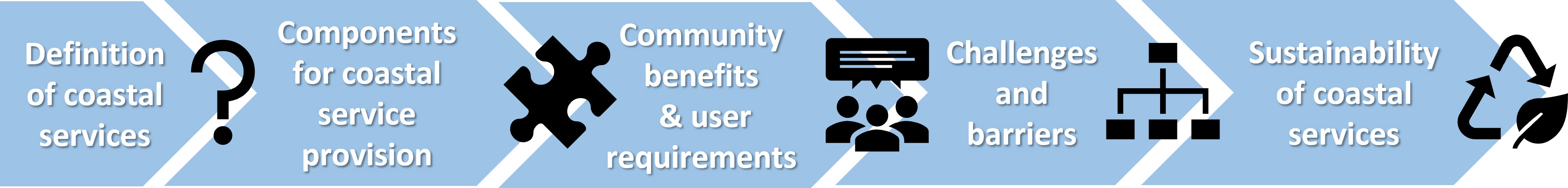
Figure 1 Elements of the EuroGOOS Roadmap for operational coastal downstream services.
1.1 Downstream coastal services
In the coming years, as the Copernicus Programme unfolds its second phase (2021-2027), several evolutions and new products could be developed and implemented by Copernicus Services (https://www.copernicus.eu/en/copernicus-services), pending on available funding. In this framework, the development of downstream services, and in particular building on the Copernicus Marine Service, could contribute to coastal services providing an improved characterization of coastal zones (e.g. dynamic nearshore bathymetry, high-resolution surface winds in coastal zones, continuity with inland waters, spectral wave information, exploiting Copernicus Sentinel missions), upgraded forecasting systems (higher resolution, inclusion of more coastal processes, improved land-ocean interfaces, data assimilation, probabilistic forecasting, more integrated systems) and co-production of model-derived information between Member States services and Copernicus Services for core users (Melet et al., 2021). The latter would allow an improved monitoring and forecasting of coastal zones, and will support policies, advance knowledge of the coastal environment and associated economies. As coastal zones represent a thematic area where the synergy from multiple Copernicus core services is needed, a strengthening of interfaces, cooperation and co-production between the services is consequential and will allow maximizing the added-value of the Copernicus Programme. This could be exemplified by the Copernicus Thematic Hub (CTH) on coastal zone, launched in June 2023. This CTH on coastal zones provides an integrated catalogue of products from different Copernicus Services that are relevant for coastal zones, to allow an easier user journey with simplified access to key information on coastal zones under a single-entry point, and with a central service desk to provide guidance and support. A first step in this direction will be carried out by EuroGOOS and OceanPrediction DCC (https://www.mercator-ocean.eu/en/presse-en/oceanprediction_dcc/) collaboration on an online operational modelling inventory Atlas (selection by regions). Ongoing collaboration and support is already existing between EuroGOOS Coastal Working Group and UN Ocean Decade Coastpredict.
In the European context, downstream coastal services are generally considered as tailor made data and information services “downstreaming” the Copernicus core services by downscaling, transforming, enhancing, and adding value to the upstream data flow, and therefore fulfilling requirements of coastal users. The added value may be given by (i) improved numerical models with higher spatial-temporal resolution and specific coastal parametrizations; (ii) new and better monitoring techniques; (iii) the integration of models and observations to provide useful information for the local coastal managers and policy makers and (iv) coupling with complementary numerical models (e.g. Dynamic Energy Budget (DEB) models) for tailored needs, (v) synthesis metrics or indicators tailored for specific sectorial needs. Such a downstream framework is more varied and fragmented than the upstream service, and it is more linked to national, regional and local policies, end-users and funding, even in consideration that such services are strongly dependent on local detailed and updated data that could hardly be produced at pan European scale.
1.2 Operational coastal services
Operational oceanography, defined by EuroGOOS as the activity of systematic and long-term routine measurements of the seas and oceans and atmosphere, and their rapid interpretation and dissemination, has been maturing especially at global and regional scales over the last decades (e.g. Le Traon et al., 2019), and is responding to an increasingly more diverse range of user needs and applications. Operational coastal services are a subset of marine, land, and climate information services, dedicated to the coastal ocean. Their “operational” qualification refers to the provision of systematic, high-quality, regularly-updated and long-term routine information on the coastal ocean, their analysis and interpretation together with a timely (near real-time or right time) dissemination to users. As such, operational coastal services provide a sustained response to user needs and support decision-making. Operational coastal services rely on operational systems, which are often integrated systems based on observations (remote and in situ) and numerical models of the ocean and coastal processes (e.g. circulation, wind-waves, sea-ice, biogeochemistry, biology, sediments). The corresponding monitoring capacity includes the provision of coastal ocean hindcasts (reanalysis), nowcasts (analysis) and forecasts of key ocean parameters relevant to coasts.
The “service” side of operational coastal services refers to the transformation of coastal ocean science-based data, together with other relevant sources of information, into added-value, qualified products and services tailored to specific user requirements. On top of this added-value product layers, additional layers can be developed to analyse and process the data into information usable by the scientific community, managers, policymakers and the downstream sector (industries). Moreover, services associated with the information delivery can be classified as the development of (i) relevant sectoral indicators, assessment and reporting activities (e.g. Ocean State Report and C3S state of the climate reporting activities of Copernicus), and (ii) service activities, such as user desk, user support, tailored user products and interaction with users to provide products that better address their requirements and needs (e.g. Le Traon et al., 2019), (iii) tailored user interfaces, apps, and delivery of compliant data for connected devices (e.g. internet of things).
2 Components for coastal service provision
Sustainable coastal service provision relies on few major components (see Figure 2). The solid foundation of coastal services are the coastal observations, both in situ and remotely sensed. This is complemented by coastal modelling that fills spatio-temporal gaps, provides a consistent description of the ocean state across a wide range of variables, and provides coastal forecasts. Characteristics that condition the relevance of coastal observations and coastal modelling for the provision of integrated coastal operational services are summarized in Table 1.
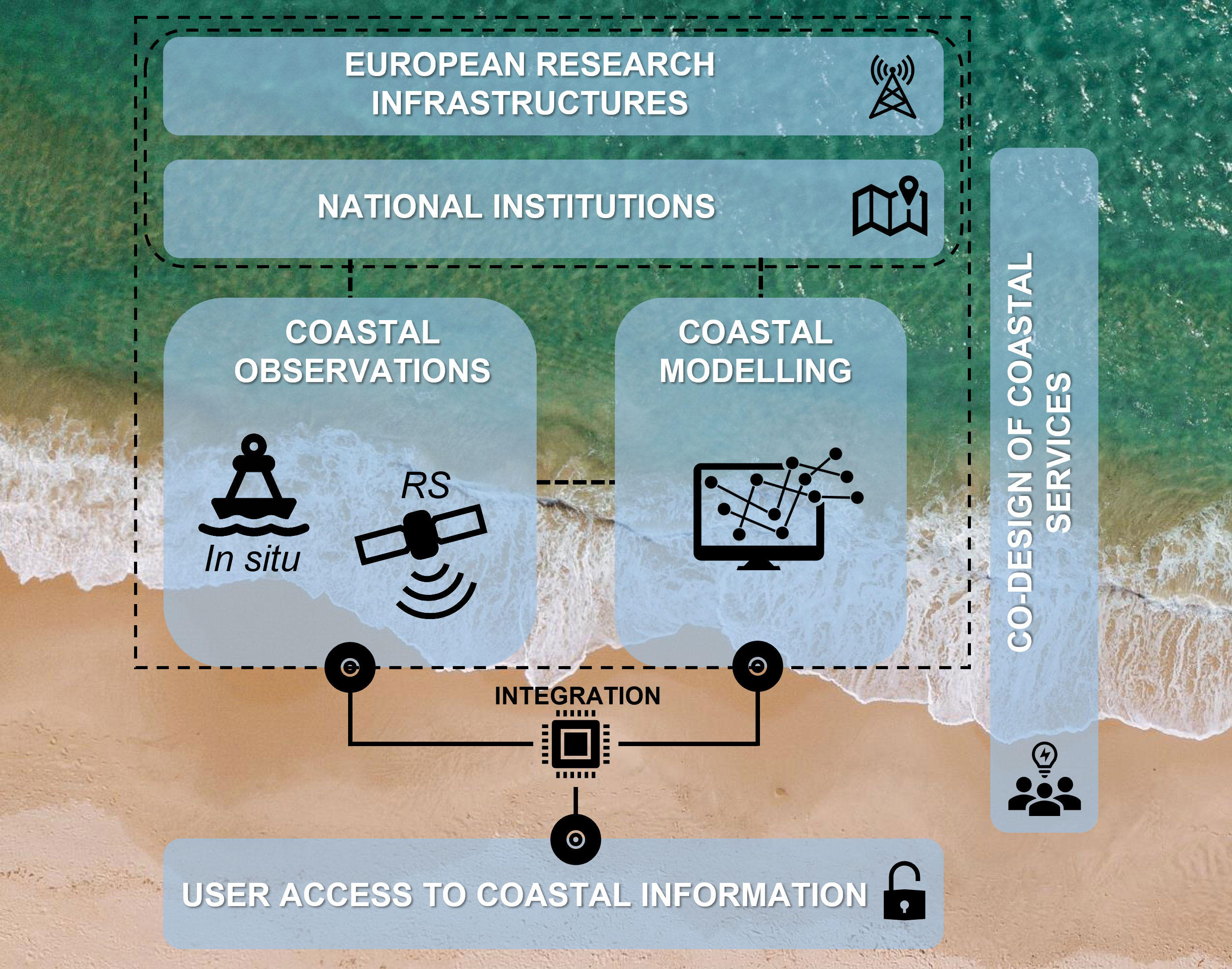
Figure 2 Components of coastal service provision. This figure has been designed using resources from Freepik.com.
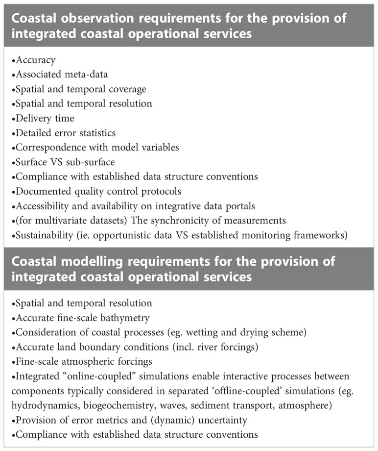
Table 1 Required characteristics of coastal observations and models for the provision of integrated coastal operational services.
Moreover, apart from the National Institutions, in the European context, European Marine Research Infrastructures are very important elements that provide integrated resources including both facilities and services. In order to guarantee the uptake of coastal observations and services, user access is crucial including access to the physical infrastructure and virtual access to resources and generated services as a first step towards coastal digital twinning. Finally, as coastal space is shared by various sectors and stakeholders, co-design of the coastal services is another important component, which guarantees that coastal services are fit-for-purpose and tailored to coastal user needs.
2.1 European marine research infrastructures and national institutions
European Marine Research Infrastructures are integrated resources including both facilities and services used by the marine science community. Apart from scientific equipment, they include scientific data collections and e-infrastructures such as data and computing systems and communication networks. European Marine Research Infrastructures are listed below in the order of relevance to the coast: the International Centre for Advanced Studies on River-Sea Systems (Danubius-RI - https://www.danubius-ri.eu/) for transitional river-delta-sea systems (land sea continuum), the Joint European research Instrastructure of Coastal Observatories (Jerico-RI - https://www.jerico-ri.eu/) dedicated to coastal waters (noting that JERICO-RI was not yet accepted for ESFRI Roadmap), the European contribution to the Argo programme (EuroArgo - https://www.euro-argo.eu/) partly covering coast but focusing on more regional and open ocean, the European Multidisciplinary Seafloor and water column Observatory (EMSO - http://emso.eu/) and the Integrated Carbon Observation System (ICOS - https://www.icos-cp.eu/) covering mostly open ocean. Specific contributions of the European Marine Research Infrastructures to coastal observations are mentioned in the relevant subsections below.
It must be mentioned, however, that most physical infrastructure is operated by national institutions using national funding. European Marine Research Infrastructures provide transnational access to the national physical infrastructure and also provide best practices/harmonisation/training as well as e-services. Currently most of the weight goes to national institutions, except for some components, like ARGO. At the moment, European Research Infrastructures are far from the optimal state.
2.2 Coastal observations
2.2.1 In situ component
Operational coastal in situ monitoring systems complement satellite observations to depict the ocean conditions. The costal in-situ component of the ocean observations has the specificity of partially relaying on land-based or on-land solution, like tide gauges, fixed platforms, and HF radars.
Tide gauges record sea level elevations continuously at the coast. Today with an extended global coverage, they have been traditionally located in ports or urbanized are because of the importance for navigations. EuroGOOS Tide Gauge Task Team brings the tide gauge communities in the European and adjacent seas and maintains an inventory of tide Gauges metadata (http://eutgn.marine.ie/geonetwork/srv/spa/catalog.search#/home). Fixed platforms include cabled stations, benthic landers, wave and multiparameter buoys and subsurface moorings that are maintained periodically and can also transmit data in real time. They carry out a large variety of multiparameter measurements and are a major contribution to the Ocean observing coastal network in terms of surface and subsurface data. They are coordinated at European level by EuroGOOS Fixed Platforms Task Team (https://eurogoos.eu/fixed-platforms-task-team/) and the European Multidisciplinary Seafloor and water column Observatory (EMSO) ERIC. Then, HF radar is a cost-effective solution to provide real-time high spatial-temporal resolution maps of ocean surface currents over wide coastal areas, suitable for many applications for coastal management (Mantovani et al., 2020). While the value of real-time data has been highlighted on many occasions for monitoring and predicting the surface drift of floating objects, long-term data series are key for the study of coastal ocean processes, their interplay, air sea interactions and connectivity between marine areas (Rubio et al., 2017). Since 2014, the European HF radar community is organized around the HF radar Task Team (https://eurogoos.eu/high-frequency-radar-task-team/) and the European HF radar node (https://www.hfrnode.eu/) with the aim of promoting this technology in Europe, as well as to ensure its coordinated development and the full exploitation of its potential for coastal services.
A major component for the in-situ coastal observation is JERICO-RI (Farcy et al., 2019), which encompasses all the solutions listed above and also counts on onboard solutions, including Ferrybox, VM ADCP, CTP profiles, and unmanned autonomous vehicles (AUVs and gliders) when they are operated close to the coast. Another component of the coastal observation is the Argo floats, which are coordinated in Europe by the Euro-ARGO ERIC, that are sometimes deployed or driven in coastal areas to monitor oceanic variables not only close to the surface but also, and very importantly, at depth.
This ensemble of physical infrastructures provides information on physical parameters such as water temperature, salinity, sea level, surface currents, waves, and/or biogeochemical variables such as dissolved oxygen and pCO2, nutrients, chlorophyll and cDOM fluorescence or pH. Furthermore, it is also important to consider in situ data routinely gathered in the framework of monitoring campaigns like the monitoring programs related to the Water Framework Directive, Marine Strategy Framework Directive and Bathing Water Directive. Such data may be accessed through the local or regional agencies responsible of water quality monitoring, official European Environment Agency (EEA) portal EIONET (hosting both public and restricted data), regional convention data portalsor other platforms like EMODnet data portals.
For the real time data, the Copernicus Marine Environment Monitoring Service In situ Thematic Assembly Center centralizes a good part of this information to feed marine Copernicus Services through http://www.marineinsitu.eu/dashboard/. An important characteristic of observing systems in the context of operational oceanography, that is particularly challenging in the coastal context, is the timeframe of data delivery to operational chains and the distinction between “near-real time” delivery of automatically processed fast-acquisition data, and “delayed-time” delivery of reprocessed, quality (re-)controlled data. Furthermore, the provision of accurate error statistics associated with observation values is crucial for the design of data-assimilation schemes and for characterizing the uncertainty associated with composite end-products (Davidson et al., 2019).
A better description of land-ocean continuum also requires improved river inputs: improved quality and availability of river runoff data, as well as optimization of data integration into the forcing of coastal models. Large-scale hydrological models can provide estimates of freshwater flows, but these estimates depend on the quality of precipitation data and reliable information on the 3D structure of the soil. Therefore, the identification and harmonization of in situ river data within European marine data services is also required.
2.2.2 Remote sensing component
Operational Earth-Observation products are available over the global ocean. Sea surface temperature, salinity, sea level, sea-ice coverage, ocean colour, surface roughness and winds are monitored routinely from satellite remote sensing data. While several limitations affect most of these products in the coastal areas due to the interference with the land and the limited spatio-temporal resolution with regard to the coastal dynamics, they still provide very valuable information to monitor the regional ocean conditions (e.g. Melet et al., 2020). Very significant improvements have been achieved in the recent years, in particular with the launch of Copernicus Sentinel-2, Sentinel-3, and Sentinal-6 satellites, providing new high-accuracy and high-resolution information in the coastal zones including estuaries. This is also reflected in the evolution of Copernicus Marine Service Thematic Assembly Centres.
For instance, the Copernicus Marine Service Ocean Colour Thematic Assembly Center (OC TAC) has provided high-resolution ocean colour datasets in coastal zones since May 2021 that are fully addressing coastal user requirements. Depending on their applications, these users require spatial resolutions of 300m over the shelf, down to 10’s of metres in coastal waters. As an example of evolving from opportunistic data acquisition to established sustained monitoring networks, in 2018-2021, the OC data streams shifted from relying on science mission to the operational OC data stream from two OLCI and two VIIRS sensors. From 2020, OCTAC relies also on the operational high-resolution products (e.g., chlorophyll-a concentration, total suspended matter, water turbidity): Landsat 8 OLI (Operational Land Imager) and the two Sentinel-2 Multi Spectral Instruments (MSI), this provide high resolution products for the coastal buffer of all European waters. The continuous and sustained operational data stream for both development targets, i.e. OC and high-resolution images, is foreseen to continue beyond 2030.
Apart form the coastal water column, there are other landward aspects that require advances from remote sensing technologies at the pan-European level. For example, there is a strong need to advance the resolution and accuracy of existing coastal topography information (e.g., EMODnet, Copernicus Marine upcoming production of satellite-derived bathymetry, Cesbron et al., 2021). While this is not particularly relevant for the open ocean, it is crucial in the coastal zone (Jacob and Stanev, 2021) for instance to improve the assessment of the effects of sea-level rise and extreme waves and surf events on beaches. Based on existing observing systems and novel AI approaches, new smart remote sensing products can be developed, e.g., using beach images from different sources (i.e., video monitoring and satellite), which is still an underestimated source of beach morphodynamics data (Vos et al., 2019).
Remote sensing can also contribute to the better description of land-ocean continuum. Apart from direct measurements of salinity and water constituents in estuaries, which are related to river runoffs, there is indirect information about the river plume structure that can be obtained from satellite data. The interpretation of these observations usually requires a combination with in situ or model data (Brando et al., 2015). Recently the Copernicus Land Monitoring Service has also delivered their Coastal Zones (https://land.copernicus.eu/local/coastal-zones) dataset that includes monitor landscape dynamics in coastal zones (land use/land cover changes). The new products covers all European coastal territories to an inland depth of 10 km and includes maritime infrastructures at Coastal Zone hotspots.
2.3 Coastal modelling
Coastal numerical models allow producing tailored products for diverse end-users by integrating ocean and land processes. An overview of European capacity in terms of operational modelling has been provided by a systematic survey conducted by the EuroGOOS Coastal Working Group (Capet et al., 2020). This survey reveals the wide diversity of model engines deployed in European waters to address hydrodynamics, waves and biogeochemistry dynamics, and highlight the current standards (2018-2019) in terms of i) technical aspects (resolution, grid typology, forecasting times, model assumptions, etc.), ii) observational data dependency (for validation and assimilation purposes), iii) preference for upstream forcing datasets and data providers (atmosphere, ocean, and land boundary conditions), iv) accessibility and dissemination of simulation data.
Numerical model implementations seeking relevance for coastal service provision first require reliable high-resolution bathymetry information, derived from observations or remote sensing. Specific coastal user needs require high resolution (<1km) which limits the spatial extent of manageable model domains (or requires the usage of unstructured grid models) and requires accurate open ocean boundary conditions for circulation, tides and waves (as limited domains have boundaries closer to area of interest). Pan-European or global atmospheric forcings data sets (e.g., NCEP or ECMWF products) are typically challenged at coastal scale and lack the topological influences affecting near-shore marine atmospheric conditions. Also, those are often disregarded in favour of regional atmospheric products (Capet et al., 2020). Particularly relevant for biogeochemical considerations, coastal models are critically dependant of realistic riverine inputs and land boundary conditions (c.f. Copernicus Marine Service SE LAMBDA project; http://www.cmems-lambda.eu/).
More generally, coastal models need to simulate complex and interactive processes that are specific to the three-fold coastal interface (land-sea-atmosphere), such as tidal amplification, wetting and drying of intertidal areas, waves diffraction, freshwater influence and river plume dynamics, upwelling processes, phytoplankton blooms, erosion and accumulation processes, seafloor drag and benthic diagenesis. Such process complexity i) induce grid topology requirements that is not met in the open sea, and ii) involve interactions between model components (atmosphere, rivers, currents, waves, biogeochemistry, sediment transport) that are typically represented in distinct “numerical modules” and evaluated in separate simulations (“offline coupling”), whereas resolving interactive processes obviously demands interactive simulations (“online coupling”). The temporal and spatial integration of the different processes (IOC-UNESCO, 2022) need to be constrained with adequate observations in a streamlined data flow, whereas established monitoring networks well adopted by the open ocean operational community (eg. Argo, Remote Sensing) are typically challenged nearshore. Because the complex coastal processes mentioned above often constitutes specific targets of, or directly influences on, end-product coastal services, the adequacy of calibrated models, is better depicted through process-oriented validation, although usual validation protocols remains relevant for systematic error characterization. After consideration of the above, coastal models can produce forecasts to support decision-making. A sometimes-disregarded contribution of numerical models is to confirm in situ and remote sensing observations by identifying outliers or unrealistic values.
2.4 User access to coastal information
Access to infrastructure services is considered in the present manuscript in a broad sense, including both access to the infrastructure itself (physical access) and to the data or other products it provides (Virtual Access).
The physical access (in person or remotely) is generally known as Transnational access (TNA or TA). TNA programs make high-quality operational field and lab infrastructures and technical support available to a wide range of users (from scientists to engineers) of different nationalities. In the EU, TNA activities started in the early 2000s in non-marine fields (Gunn, 2007) and since the FP7, TNA has become one of the three mandatory components of the Integrating Activities (European Commission, 2009). In the marine domain, access to facilities becomes a component of EU I3 projects back in 2010 (i.e. JERICO, MESOAQUA and AQUAEXCELL). Since then and due to its success, access activities are part not only in I3 but also in INFRADEV projects (EuroFleets, FIXO3, JERICO-NEXT, AQUACOSM, EuroFleets+, JERICO-S3, JERICO-DS, EMSO-LINK, DANUBUS-RI, EUMarineRobots, etc). Moreover, most European Research Infrastructures (e.g. EMSO, ICOS, EMBRC, LifeWatch) have an access policy with well-defined procedures. Although TNA at EU level is becoming mature and open to users outside Europe, established access at national level (National RIs) is rather rare (e.g. HIMIOFOTS, Greece). On the other hand, looking outside Europe, most observing systems (IOOS, IMOS) limit access only to Virtual Access (VA) or Service Access (SA), which generally concerns data and computing facility access (considered by some as a “service” sensu stricto).
2.5 Co-design of coastal services
Involvement of stakeholders and their participation in the co-development of the service is of vital importance to ensure a successful roll-out and the buy-in of the end users. Where possible, the involvement should extend beyond the group of the target end-users of the service. All stakeholders, such as regulators, industry members, scientists and members of the civil society should be involved in the co-design process. These stakeholders represent different perspectives, have different requirements, and therefore contribute to the co-design in different ways. Regulators can provide information on safety and environmental legislation and contribute to the co-design with Codes of Practice evaluation and interpretations. Industry members can grant access to vital local validation information by sharing their in situ observations that are otherwise classified, and also have accurate vision on technical requirements for the services. Scientists will contribute with the interpretation of environmental data and modelling expertise to derive forecasting products. Finally, the general public can provide feedback on forecast and other information products thereby guiding future developments.
In the European context the necessary coastal service components are present, functional and to large extent fulfil their complementary roles. The in situ component collects locally relevant information and targets specific problems (thematic), the remote sensing component provides complementary information with large spatial coverage but limited to certain variables, and the modelling component offers forecasting capacity, although limited to validated sets. Emerging European Marine Infrastructures contribute to the integrated and harmonized access to scientific resources by promoting community data sharing, replicability, availability, and filling gaps in observation networks. These components are scattered, however, keeping them far from their full potential. For instance, the in situ component still lacks standardized procedures and data management in some thematics (especially biogeochemistry and biology), and major gaps still exist in the observation network (spatial, temporal, vertical, variables). The roles and responsibilities of European Marine Infrastructures for coastal service provision compared to national institutions is still not clear and delivered coastal observations and model outputs require further integration before users can exploit the coastal services. Their sustainable financing is also a difficult question. It is therefore important to further strengthen these components to guarantee to sustainability of coastal services, and this must be done with community benefits and user requirements in mind (see next section). The coastal service components also require scientific evolution to fulfil the need of Digital Twinning concept where all components need to function in a more efficient and harmonized manner.
3 Community benefits and user requirements
The development and sustained availability of operational oceanography at global to regional scales stimulated the development of downstream coastal services, driven by the tremendous social, economic and ecological value of coastal zones. Indeed, coastal zones provide many services to human society, including food, energy, flood safety, ocean recreation, tourism and coastal livelihoods. Besides those services coastal zones are also contributing to water quality maintenance, waste treatment, biogeochemical cycling, regulating services, and supporting the green and blue economy. The need to translate the massive amount of ocean data and information into actionable information for decision support that can be effectively used to assist coastal zone activities, implement policies and directives further motivates the development of dedicated coastal products and services.
3.1 Blue coastal economy in europe
Seas and oceans are drivers for the European economy and have great potential for innovation and growth. Established sectors of the European Blue Economy (economic activities related with marine and maritime activities) include marine living resources (fishing, aquaculture and processing sector), marine non-living resources (e.g. oil & gas), marine renewable energy (wind, tides, waves, etc), port activities, shipbuilding and repair, maritime transport and coastal tourism. These sectors represent 5 million people employed in 2018, a number that increased by 11.6% in a single year and amount to 2.2% of employment in Europe (European Commission, 2020). While the marine environment is typically associated with the above traditional activities, it also houses an increasing number of emerging, innovative sectors, including some marine renewable energy (i.e. ocean energy, floating solar energy and offshore hydrogen generation), blue bioeconomy and biotechnology, extraction of marine minerals, desalination, maritime defence, and submarine cables. These sectors offer significant potential, especially regarding renewable energies where the EU is in the world lead hosting 70% of global ocean energy (wave and tidal) installed capacity, and 86% of the world’s total installed offshore wind capacity at the end of 2018 (Díaz and Soares, 2020). To give an idea of its current expansion, jobs in the offshore wind energy sector have multiplied nine-fold in less than 10 years (European Commission, 2020).
Beyond sustained direct economic activity, the ocean also has an economic value in terms of provision of resources, habitat for marine life, carbon sequestration, coastal protection, waste recycling and storing, processes that influence climate change and biodiversity, as well as cultural and aesthetic values. Increasingly recognized by authorities (see novel introduction of dedicated chapter in EC Blue Growth report 2020), coastal ecosystem services1 directly benefit mankind from regional (e.g. coastal protection) to global (e.g. carbon sequestration) scales, and are managed under regional (e.g. regional sea conventions), national (e.g. national strategies for the Green Transition) and European legislative frameworks such as the Water Framework Directive (WFD), Marine Strategy Framework Directive (MSFD), Marine Spatial Planning Directive (MSPD) and Common Fishery Policy (CFP).
3.2 Benefits and Requirements through examples of service uptake
Blue Economy activities that involve operations at sea, but also downstream activities that depend in some ways on the accurate information and forecast of the state of marine and coastal environment, directly benefit from the availability and adequate delivery of operational coastal services, as defined in Sect. 1. Indeed such services may:
● Reduce uncertainty in short-term evolution of the coastal environment and its ecosystem;
● Allow offshore operators to improve environmental footprint, efficiency, safety, product/service quality, and costs;
● Enable effective and efficient marine spatial planning and legislation for environment, fisheries, transport, marine renewable energy, border control, and defence;
● Ensure that usage of the sea does not disrupt marine ecosystems, and provision of ecosystem services;
● Stimulate competition and innovation in established and emerging maritime sectors.
A rich portfolio documenting use-cases of coastal services uptake can be found for instance at the Copernicus Marine Service User Uptake portal (https://marine.copernicus.eu/markets/use-case-demos/?segment=coastal-monitoring) and the ETOOFS Guide (IOC-UNESCO, 2022). We selected below a few examples from key coastal sectors to illustrate user implications in co-designing the services, and the associated economic benefits (see Figure 3). These examples do not aim to offer a comprehensive overview but instead present the way forward by being “the first stepping stones” towards providing coastal services. While not complete, our selected sectors (aquaculture, ports, renewable energy, tourism, cross sectoral) are in the center of the European Green Deal and its new approach for a sustainable blue economy, moreover they cover most EU Established Blue Economy sectors (European Commission, 2022).
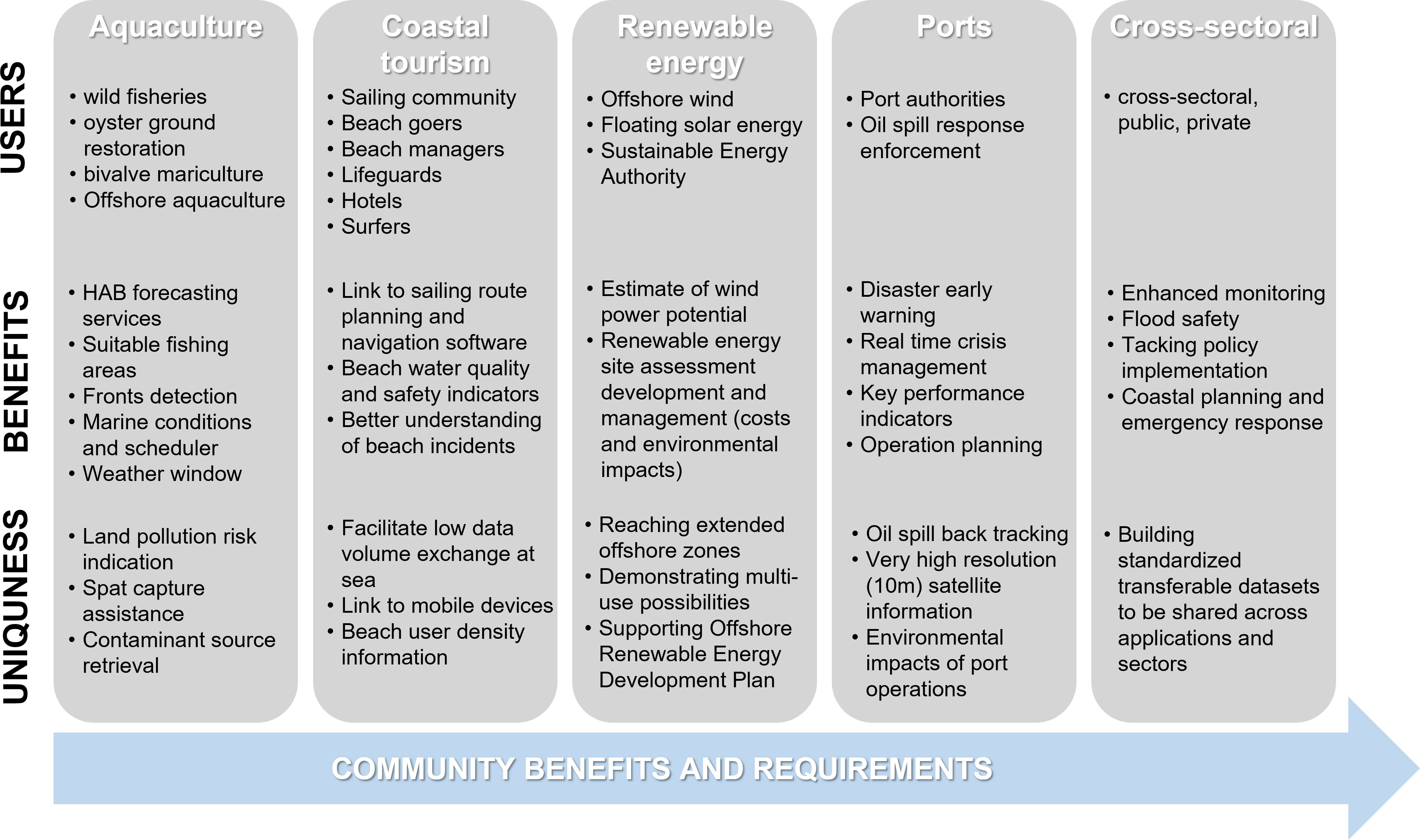
Figure 3 Sectoral community benefits and requirements of coastal services illustrated through specific coastal users, their benefits from the services and the uniqueness of the developed services.
Regarding user feedback, based on the 2022 annual survey sent to Copernicus Marine users, 94% of users that completed the survey and selected “coastal services” as their main blue market declared being satisfied, amongst which 65% declared to be very satisfied.
The number of Copernicus Marine users selecting “coastal services” as their prime blue market (amongst the 12 categories of the Copernicus Marine Service blue markets) as well as the volume of data being downloaded for this blue market have increased over the past 2 years. It must be noted, however, that this only gives a partial view as many users are interested in different blue markets and do not necessarily select “coastal services” as their prime blue market, even though they are using Copernicus Marine for coastal purposes.
3.2.1 Examples from the aquaculture sector
Examples of novel coastal services to the aquaculture sector include mapping of suitable fishing areas, fronts detection, marine conditions and scheduler, land pollution, site prospection, spat capture assistance, and contaminant source retrieval. Such services are provided by FORCOAST (https://forcoast.eu/) in eight aquaculture pilot sites covering five European regional waters: North Sea, Baltic Sea, Mediterranean Sea, Black Sea and the coastal Atlantic Ocean. These services are Copernicus-based services that incorporate Copernicus products, local monitoring data and advanced modelling. Benefits of the provided FORCOAST services were appreciated by end-users, Portuguese oyster farmers in the Sado estuary managed to save time and cost in their day-to-day operation, for instance.
Providing near real-time and forecast information for the aquaculture industry along Europe’s Atlantic coast is also of vital importance in mitigating the effects of Harmful Algal Blooms (HABs). Recent projects that aimed at the co-development with end users and demonstration of HAB forecasting services as one of the societal needs from the coastal observing and forecasting systems include the FP7 Asimuth (Cusack et al., 2016), H2020 AtlantOS (Cusack et al., 2018) and Interreg Atlantic Area PRIMROSE (https://www.shellfish-safety.eu/). Further operational services developed in recent years in response to the aquaculture sector needs to include the Weather Window Tool (Dale et al., 2018) designed and developed within the framework of the AtlantOS project and currently rolled out across the European Atlantic coasts in the framework of the Interreg Atlantic Area MyCOAST project (http://mycoast-project.org/). Identification of suitable sites for offshore aquaculture is also possible based on the observational and modelling systems and relevant demonstration of the service in response to the industry requirement was also performed in the framework of AtlantOS (Dale et al., 2017). Co-Clime (https://www.coclime.eu/) also develops coastal climate services for the aquaculture industry related to HAB outbreaks in the future climate. Coastal models may also be of help for the management of shellfish production areas, in order to reduce risks related to bacterial contamination. As shown by the CADEAU project (Northern Adriatic sea water quality for aquaculture and tourism sectors) a system of numerical models downscaling Copernicus Marine Service products to the coastal scale, may be used to assess the impact of bacterial pollution sources reproducing transport, diffusion and fate of bacteria.
Last, but not least, all the data and information produced by operational coastal services may be used in the framework of the Maritime Spatial Planning Directive to identify Allocated Zones for Aquaculture (AZA), following national and international guidelines (e.g. FAO (Macias et al., 2019)), as shown by use cases as AQUAGIS (European Aquaculture Society - ePoster Viewer (aquaeas.org)).
3.2.2 Examples from the coastal tourism sector
Following enquiries from the coastal tourism sector, various coastal services have been developed to this community. A good example is in Ireland where based on the request of the sailing community, Irish Marine Institute (IMI) developed a tailored product based on the North East Atlantic operational forecasting model. Surface currents are subset over five geographical areas around the Irish waters and the English Channel and published in a GRIB format via an ftp site https://sftp.marine.ie/. The service was developed in collaboration with some of the sailors that contacted the IMI. The GRIB format requirement and the subset were determined by the route planning and navigation software OpenCPN (https://opencpn.org/) and constraints on the download size while at sea, respectively. The size of each of five subsets is around 20 MB. Initially, the currents were provided in knots, which was subsequently changed to m/s, following upgrades of OpenCPN. According to the feedback received, this product was used during the Fastnet Race, one of the oldest and biggest races in the Irish and UK waters.
Another Irish example serves beach goers. The Irish Environmental Protection Agency in collaboration with Local Authorities and the Department of Housing, Planning and Local Government run a webpage https://www.beaches.ie, where the latest information on water quality and others is presented for 204 beaches in Ireland. Met Eireann (the Irish national met service) and the Marine Institute contribute to the information provided with current weather and weather forecasts and tidal information, respectively. The users can check the latest water quality information and if there are any swim restrictions in place (all current restrictions around the country are displayed on home page), find information on amenities, historical water quality information, photos, aforementioned weather and tides information and other. With the geolocation turned on, the users can find the nearest beaches and their latest water quality status. A similar application, carried out in the framework of the CADEAU project (Bruschi et al., 2021), provided data and information for one caste study, to assess the potential impact of bacterial pollution sources on bathing waters (as defined in the EU Bathing Water Directive) and help bathing waters’ managers in identifying potential sources of impact and planning mitigation measures.
The coastal tourism sector also benefits from advances in video-monitoring systems. Video-monitoring systems applied to coastal areas are based on high resolution cameras installed mainly on beaches, ports protection structures as well as natural coastal stretches. For example, in the Basque Country region in Spain, 20 operational stations are distributed along the 100 km of the coastline (KOSTASystem). These cameras work operationally and rely on photogrammetric techniques, which enable the transformation of the captured oblique images (2D) into a rectified metrical one. The processed images allow the development of direct monitoring services and the integration of key observations to improve coastal forecasts. In the long term and climate change context, the main results have been obtained in beach morphology monitoring. In addition, in the short term, the network operates during extreme wave emergency situations by monitoring wave overtopping and flooding. It is also used for daily beach management during summer, improving beach safety by means of a rip current detection, predicting wave induced currents, and providing information about beach users density. For this last application, KOSTASystem has shown its benefit in the COVID-19 context to coastal managers and beach users and helped in ensuring and implementing the social distancing recommendations (Epelde et al., 2021). This still emerging but now well-established technology will benefit from enhanced European collaboration, harmonisation, and best practices exchanges and integration in the coastal observing network.
Beach video-monitoring services were also developed in the Balearic Islands, a hot spot for tourism in Europe. The Balearic Islands Coastal Observing and Forecasting System (SOCIB) provides real-time images of three representative beaches in Mallorca and Menorca Islands, allowing to characterize the state of nearshore waves and currents as well as the evolution of the coastline, which is an essential input for decisions on coastal protection and governance. Also targeted at the beach, coastal communities and tourism sector, the beach lifeguard product (Heslop et al., 2019), developed in collaboration with the relevant local authorities, provides the meteocean conditions for the 352 beaches of the Balearic Islands, together with the associated 48-hour predictions generated by SOCIB forecasting systems. It is accessible through a mobile application, easing the elaboration of lifeguards daily reports with unified criteria, and so the understanding of the relation between beach incidents and marine conditions, contributing to an improved management and planning. As a freely available service, any beachgoer can also benefit from it to check the conditions at their favourite sites. Specific services were also developed for several hotels in the Balearic Islands providing local information on beach, water temperature, waves and weather conditions through dedicated seaboards (e.g. http://seaboard.socib.es/clm).
National marine forecasting agencies also serve the coastal tourism sector. The Marine Forecasting Centre of Belgium of the Royal Belgian Institute of Natural Sciences (RBINS) issues 5-day forecasts of the marine conditions in the North Sea twice a day with a high resolution for the Belgian part of the North Sea. These forecasts are used in numerous applications to support the missions and activities of Belgian and foreign public sectors, among them the tourism and leisure industries. The main users of this site from the tourism sector are surfers. Surfers use the application for mobile devices to schedule their sessions for good wave and current conditions.
3.2.3 Examples from the renewable energy sector
The renewable energy sector is a prominent player in the Blue Economy and therefore one of the main potential users of coastal services. Apart from making accessible Copernicus data products for this sector, the ODYSSEA project (https://odysseaplatform.eu/) derived its own wave and wind power products which are produced operationally for the renewable energy sector and shown in the Marinomica (https://marinomica.com/) platform. ODYSSEA also ran dedicated assessments, such as the one that revealed huge wind power potential in the Thracian Sea. Within ODYSSEA the collaboration with offshore companies is also guaranteed by mounting in situ sensors on their platforms which creates an improved involvement and trust between user and data provider.
Current bottlenecks relating to the large-scale installation of ocean multi-use activities are addressed by the UNITED project (https://www.h2020united.eu/), which demonstrates business synergies and benefits of ocean multi-use; provides a roadmap for deployment in future multi-use sites and potential scaling barriers to be addressed through best practices and lessons learnt. UNITED also enhance the technology readiness levels of multi-use solutions, involving industrial actors and integrating knowledge, technologies and facilities. It will also propose business models to reduce operation costs and generate benefits to all sectors involved.
Another example of coastal services for the renewable energy sector is Ireland’s Marine Renewable Energy Portal (http://www.oceanenergyireland.ie/), an on-line access point for all relevant information and data related to Irish marine renewable energy activity and resources. The portal is a ‘signpost’ to facilitate public access to marine data, maps, tools and information for renewable energy site assessment, development and management. The portal has been developed by the Sustainable Energy Authority of Ireland (SEAI) and the Marine Institute in accordance with requirements set out under the Offshore Renewable Energy Development Plan published in 2014 by Ireland’s government.
3.2.4 Examples from the port sector
Coastal areas with industrial ports and harbors are among the locations most at risk from oil spill pollution, which heavily impacts the aquatic and ecological life, the coastal infrastructures, and the local economy. This underlines the need for timely and accurate coastal services for operationsand disaster response. Oil spill models predicting the fate and the transport of the oil slick have been recently enhanced by downscaling from state-of-art regional models (e.g. Copernicus Marine Service) and to very high-resolution hydrodynamic models for coastal and harbour areas. The WITOIL platform (www.witoil.com), an innovative web-based decision support system to facilitate emergency management in the case of oil spill accident (Liubartseva et al., 2016), includes these new advancements for the coastal harbour area, e.g. Port of Taranto, in north western Ionian Sea (Liubartseva et al., 2021). The oil spill modelling outputs for the area of Taranto are also used in the IMPRESSIVE project (https://impressive-project.eu/), which integrates in web platform both models downscaled by Copernicus Marine Service and Earth Observation (satellite, flying drone) data for pollution control in harbors and coastal areas. A further coastal service in water monitoring and oil spill pollution is the OKEANOS project (https://parsec-accelerator.eu/portfolio-items/okeanos/), a web-based integrated and intuitive service combining open-source satellite observations (i.e. affordable), artificial intelligence and high-resolution ocean modelling (i.e. accurate).
Further examples of coastal information services tailored to the needs of the port sector are provided by the HiSea project (https://hiseaproject.com/). The HiSea information services include (i) early warning service on potential risk factors issuing alerts on storms, harmful algal blooms, faecal contamination and other hazards; (ii) real time crisis management regarding pollution accidents to identify the appropriate responses; (iii) key performance indicators regarding fish growing rates, environmental conditions, or the level of vulnerability to storms for vessels; (iii) Information for planning operations including accurate and reliable meteorological, hydrodynamic and water quality forecasts; and (iv) a knowledge data base built on cause-effect relations that will help better understand and manage future operations.
3.2.5 Cross-sectoral examples
Coasts are often home to multiple activities where different sectors share the coastal space. In these cases, coastal services need to fulfil cross-sectoral requirements. The Venice Lagoon is a good example where cross-sectoral services are needed (H2020 CERTO Project- https://certo-project.org/) as it has significant amount of biogeochemical, eco-geomorphological, and anthropogenic processes (e.g. mass tourism). In this area, coastal downstream users and stakeholders highlighted the need of satellite products to (directly or indirectly) support the provisioning of information and advice on the sustainable management of human activities affecting, and affected by, marine ecosystems. For the Venice lagoon, the Copernicus Sentinel-2 satellite proved to be a suitable tool for monitoring the evolution of the Venice lagoon water transparency as well as of main European rivers largely affected by goods transportation, tourism, and agriculture (Braga et al., 2020; Zambrano-Monserrate et al., 2020; Yunus et al., 2020). Venice also need coastal services (storm surge forecast) to operate its mobile flood barriers (called MOSE) at each inlet of the lagoon. These gates rise from the seabed when needed to stop the tide from entering the lagoon (fully operational by the end of 2023). The operation of the MOSE will mainly depend on the water level forecast. Hence, water level forecasting is one of the fundamental aspects of the closing procedure of the mobile gates. Improving the reliability of these forecasts will contribute to avoid missing or false closures due to too low or too high predictions (Umgiesser et al., 2021). This will save money as missing closures could result in flooding and damage to the city of Venice (shops, low lying apartments), while false closures will unnecessarily delay ship passage for its industrial and touristic ports (Vergano et al., 2010). Moreover, the forecast is essential to warn the population from imminent danger to life and goods, and the preparation of boat travel and walkways for pedestrians inside the city. The fact that the company operating the mobile gates depends increasingly on the forecast done in conjunction with the City Municipality, the Ministry of Environment, and the National Research Council, shows that this service offered to the city and its population is highly valued both for information and decision making.
Another representative example of cross-sectoral synergies is the coastal service provided in Italy by the Ligurian agency for the protection of the environment (ARPAL) (https://marine.copernicus.eu/print/pdf/node/1864). Here a set of marine water quality applications was developed by the private sector, in order to deliver coastal monitoring and forecasting services which help fulfill its institutional mission, including among the rest, the monitoring and forecast of bathing water quality, of river fine sediment plume and oil slicks in the sea, of algal bloom and aquaculture pollution. The system adopts a downscaling approach of circulation numerical models based on the core products of the Copernicus Marine Service: very high resolution hydrodynamic and water quality forecasts, up to 50 meters in certain coastal areas, are provided operationally on a daily basis. Such tools represent a fundamental support for coastal planning, response to emergencies and more broadly for the institutional activities of ARPAL. This scheme is particularly relevant since it proposes a virtuous synergy between the public and the private sectors where downstreaming services of public benefit are developed, implemented and updated by private entities whereas they are managed and delivered by public local institutions, which should be ultimately the responsible subjects of a public service.
Finally, the Interreg Atlantic Area MyCOAST project demonstrates the benefits of standardization of datasets used as inputs to cross-sectoral services, which enables their transfer between different coastal observatories. From around fifteen tools existing in the partnership, six were shortlisted for these demonstrations:
● The Flood Risk Mapping Tool, using historical sea level and wave predictions to provide high resolution mapping of the flooding risk based on return periods;
● MyCOASTLCS, enables the visualisation, identification and quantification of pollution hotspots of non-reactive, buoyant, slow diffusing and short-lived substances;
● ADRIFT, to aid them in marine search and rescue operations in Galway Bay;
● LI4MOHID, providing forecasts of the fate of hazardous noxious substances and oil spills;
● The Weather Window Tool, providing a user-friendly interface of short-term wave forecasts;
● The OSERIT tool to aid the risk assessment of oil spills, also used to follow up high risk operations such as guiding damaged ships through Belgian waters.
4 Challenges and barriers to coastal services provision
In order to guarantee the sustainability of (operational) coastal services the main challenges and barriers to coastal service provision must be analysed. In this section we group the challenges into two categories: (1) challenges and barriers to user uptake, and (2) challenges and barriers to technical integration. Addressing these two types of challenges require very different solutions. While the first focuses on the service-user interface, the second deals with the interface between physical regions, multidisciplinary domains and multi-sourced data. Despite their distinct nature they are equally important to overcome.
4.1 Challenges and barriers to user uptake
As mentioned above there is a wide and complex panorama of coastal service providers (including core and downstream operational services, delivered both from public or private sectors) and end users (coming from both the public sector, including here national, regional and local agencies, together with the academia, and from the private sector, with very different types of enterprises involved), resulting in a very diverse casuistry of coastal service provider-user relationships. User uptake is one of the main challenges faced by operational coastal services and it can determine the service sustainability. To succeed, it is mandatory for coastal services to deal with and put down the listed barriers. Challenges and barriers to user uptake are equally varied, and they depend for each case mostly on the maturity level of delivered services, as well as on the tradition in the services uses.
Some of the blue economy sectors (such as port activities, shipbuilding and repair, maritime transport, marine resources (oil, gas and renewable energies), search & rescue and fight against pollution operations) have a long tradition in the use of operational oceanography services; on the other hand, there are other emerging sectors (i.e. aquaculture and fisheries, coastal tourism, water quality, coastal (smart) cities management, etc.) where the use of operational coastal services is more recent, but it is being rapidly increased and generalized. It can be expected that challenges and user-uptake barriers vary across sectors of the Blue Economy, there will not be the same level of end-user adoption in all areas of activity.
Note that no matter the level achieved by a coastal service in terms of maturity or user implication, there are always challenges and barriers to user uptake that must be overcome. Among others, some of these most common barriers (with example of actions reported by different services to overcome them) are summarized in the following categories:
4.1.1 Lack of end-user knowledge on available products or new services
This usually happens to new users who get access to a service for the first time or to experienced users when facing service or product upgrades. At this stage, it is key for the service provider to give relevant guidance to the end-user. The potential barrier to the user uptake can be minimized when the service counts with some ServiceDesk facility in place. Likewise, development of training activities (i.e., setting up email campaigns, combined with tailored in-app guided tours or training sessions) can be quite helpful to let users’ understand the product showing the value they expect to receive from using it. Established operational oceanographic services, such as the Copernicus Marine Service core one (Le Traon et al., 2019) or those delivered by European and national agencies, count with this needed ServiceDesk facility (see Copernicus Marine User Uptake Report, 2022)and they are usually involved in end-user training activities (see the Copernicus Marine e-training service: https://marine.copernicus.eu/services/user-learning-services) and in end-user engagement actions related to the promotion of noticeable use cases, highlighting the effective Copernicus Marine downstreaming (see Copernicus Marine Use Cases: https://marine.copernicus.eu/services/use-cases; Sotillo et al., 2019). However, this is not the case for all the existing coastal services. In some cases, for instance in those services delivered by smaller organizations or by producers more focused on specific R&D aspects, it is possible that less resources may be focused on this end-user uptake, making end-user awareness an issue. On the contrary, this lack of end-user knowledge should not be a barrier for very specific tailor-made applications, built by a provider for a single targeted identified end-user (i.e. a business company, or a specific department or service from some organization).
4.1.2 Lack of service capability to anticipate end-user needs or doubts
Even if a service is very well designed, knowing anticipatedly most of the potential end-user doubts and questions, there will always be instances when users struggle and will require some on-the-fly support. Here, a ServiceDesk action will be also required. And most probably this action should count with support of some technical teams to provide adequate resources to overcome end-user challenges faced with the service products. To face this barrier, ocean and coastal services should count not only with a service desk ready to act (in a few clicks, by an email, in 24/7), but also expecting some technical support. Economies of scale can certainly benefit service providers to face their user-uptake, and a good option can be to build a strong service end-user community. This is quite strategic, and possible, when different end-users with commonalities are using the same service or variants of an application delivered by a single service provider (e.g. the case of the Puertos del Estado SAMOA services, focused on providing customised coastal and local met-ocean information for the different Spanish Port Authorities; see Sotillo et al, 2020). However, building end-user communities may not be possible for all coastal services.
4.1.3 End users and service providers may speak different languages
Difficulties in the communication between service providers and end-users are quite common. They are mostly motivated by the very different perspectives and conceptions that each one has on the service itself. Ocean literacy is key to ensure a log-term reduction of miscommunication risks. The IOC/UNESCO and many national reports emphasize the need for increased ocean literacy to improve economic stability and national security, and to allow society to understand critical issues associated with important ocean-related topics spanning ecology, trade, energy exploration, climate change, biodiversity, the ocean, and human health, and developing a sustainable future (Santoro et al., 2018).
Communication issues arise especially when coastal service interfaces are being designed: for users, enhancement of the user-friendliness is a common request (service interfaces never seems simple enough); on the other hand, for providers, and especially when very specialized research teams are involved in the user interface development, it is usually difficult to renounce delivering the several aspects and potential functionalities that a service can provide (resulting in an enhancement of interfaces complexity). Therefore, a service needs to achieve some commitment to work with an adequate level of simplicity (facing the service delivery) but avoiding any loss in terms of scientific or technical rigour. This is key to ensure co-design approaches. The service provider – end user dialogue is very important, and usually will imply for the services to dedicate specific resources on building ad-hoc end-user tools. In that sense, Alvarez-Fanjul et al. (2018) illustrates how the use of a new specific interface tool was key to ensure proper exploitation, by the 25 Spanish Port Authorities, of the different met-ocean information delivered by Puertos del Estado (including here products delivered by the general PdE operational oceanographic services already in place and the new SAMOA port services). Another success story is the H2020 FORCOAST project, where the end-user groups were small scale businesses in wild fisheries, oysterground restoration and bivalve mariculture. These users were only interested in simplified information services, not data services. For this reason, data (measured or modelled) is not delivered to them, only instant messages via Telegram containing a simplified bulletin. For instance, the FORCOAST Marine Conditions and Scheduler for oyster farms forecasts conditions at a user-defined location and sends a bulletin that displays the water level in relation to working environments like wind, precipitation, and daylight. A working limit can be set, for which the bulletin will provide some additional visual support, enabling for faster information extraction.
In a more general framework, the UN Ocean Decade identifies among their challenges (the 9th) to “ensure comprehensive capacity development and equitable access to data, information, knowledge and technology across all aspects of ocean science and for all stakeholders.” (IOC-UNESCO, 2021). Some evolution in ocean literacy (as pointed in McKinley et al., 2022) and in communication processes between end-users and service providers (understanding them as new forms of collaboration, participation and joint action by multiple stakeholders, through highly participatory processes involving experts and citizen stakeholders) are key to ensure sustainable ocean policies in the future (Britton et al., 2021).
4.1.4 Coastal service sustainability: a service cost evaluation and some acknowledgement of the value received by end-user usages are needed
There is a need for usage metrics to understand how users adopt coastal services and for some specific work to identify how users are improving their activities with them. If possible, together with an economic analysis. Count with this kind of analysis, can play a significant role in the sustainability of operational coastal services. However, these analyses cannot be done without specific actions and close relationships between players. These analyses are complex (Mehvar et al., 2018) and not always easy to implement and need a strong implication from the end-user organizations (with deliveries of a lot of information, not always easy to get, on their operations and processes, together with their economic costs and benefits). Collaborative frameworks, such as R&D Projects, can help to co-develop this service end-user cost/benefit analyses (i.e., in the aforementioned Interreg Atlantic Area MyCOAST project, focused on developing end-user interoperable tools addressing coastal risks, has among their objectives to get some economic assessment on the impacts that using operational coastal services have in some of the project targeted end-users).
Need of service resources to understand users activities (needs and gaps) and possibilities to adopt new strategies or modification of procedures. A very common high risk: “no time for updates in some end-users”. In this case, it is useful for the promotion of events to generate collaborative frameworks (i.e. user uptake projects, demonstrator activities, participation of end-users in advisory groups, public-private collaboration to foster specific in-app). Likewise, it is needed to trigger initiatives to understand how users may adopt coastal products and its features. This kind of gap analysis should be generalized, and it can be organized at different levels with a regional/national, European or global perspective (see in the following section examples of gap analysis). Finally, note that to produce an effective gap analysis is needed contacting end-users to collect information from their uses of coastal services, creation of an improved understanding of the needs, identification of existing gaps and deliver ways forward recommendation for future evolution of services in order to fulfil detected gaps. In that sense two examples can provide a nice example of a gap analysis scope and of the importance of its recommendations. The report on data services for Spanish intermediate users at coastal zones (Fernandez et al., 2020) created to support European Environmental Agency (EEA) action and the paper Geraldini et al., 2021 describing the methodology and the results of the analysis on Italian Institutional Users needs in terms of EO products and services and the subsequent gap analysis with reference to existing Copernicus and EMODnet products.
4.2 Challenges and barriers to technical integration
Integration of multidisciplinary coastal data needs to be performed at different levels to address the service requirements as adequately as possible. For instance, while operational Earth-Observation products are available over the global ocean, coastal in situ monitoring systems complement satellite observations to depict the ocean conditions in the coastal area (Nechad et al., 2015; Lavigne et al., 2021).
The integration of these multiple components provides an important added value for the generation of reliable coastal services. Notice that this integration occurs at several levels:
1. Technological integration allows multiparameter observation at the same place and time;
2. Integration of data from different observing platforms, including in situ and remote sensing, and modelling systems through data assimilation techniques or other blending approaches. This requires the harmonization of operation of the systems and processing, standardization of the data and information on observation uncertainties, as well as streamlined operational data flows;
3. Seamless integration between terrestrial, coastal and open ocean compartments through enhancing the synergies and connections of the existing observatories and modelling systems - including integration with drainage basin modelling, river modelling and sediment transport modelling;
4. Multidisciplinary data integration allows physical-biogeochemical coupling (like monitoring or forecasting drift of contaminants or physical conditions favouring the development of species that can generate algae blooms and/or invasion of some species (i.e. jellyfish) or appearance of new species) and enables ecosystem approaches (for instance for integrated fisheries and aquaculture or coastal water quality management).
When the design of the observational systems and modelling strategies ensure the complementarity/compatibility of the observed and modelled variables, which requires narrow collaboration/coordination between modelling and monitoring experts (between or within research institutes), the resulting data can be assembled (blended) in real-time or delayed-mode to provide added-value integrated products or services as for example discussed in Tintoré et al., 2019. This process can be assured by regional or coastal observatories that can distribute the resulting product services near real-time, after applying the necessary basic quality control procedures. These data could also reach the national and aggregated data repositories, enabling their exploitation by a large variety of users.
4.2.1 Data fusion and aggregation
The pan-European data infrastructures (like Copernicus Marine Service, Copernicus Marine Service in situ TAC, DIAS, EMODnet, SeaDatanet, EIONET) provide a rich background for the development of integrated coastal services, through increasing the open-access availability to homogenised operational and historical datasets and data products. Global multi-observations products are also included in the service catalogue of Copernicus Marine Service. They provide through different data fusion/blending techniques, products derived from a combination of two or more sensors, satellite and in situ, including 3D temperature, oxygen, salinity, geopotential height and geostrophic current fields, 2D sea surface salinity and sea surface density fields, total surface and near-surface currents, vertical velocity fields, surface carbon data sets of FCO2, pCO2 and pH, nutrient vertical distribution and particulate organic carbon and chlorophyll-a fields (some of them in near real time).
Modellers and forecasters combine these multi-sensor and multi-disciplinary observations with the outputs of numerical models so as to optimize the 3-dimensional ocean conditions used to initialize the predictions. Capet et al. (2020) provide a recent review of the operational modelling and predictive capacities in European Seas in terms of hydrodynamics, waves and biogeochemistry. Recent examples demonstrate the benefit of assimilating HF radar, gliders, CTDs and tide gauge observations in European coastal models (Vandenbulcke et al., 2017; Hernández-Lasheras and Mourre, 2018; Schulz-Stellenfleth et al., 2021; Hernández-Lasheras et al., 2021). Other options for data assemblage/blending relies on the use of statistical and variational methods directly on complementary observational data sets, based on different techniques like optimal interpolation, variational analysis, Self-Organizing Maps, Data Interpolating Empirical Orthogonal Functions (DINEOF), or the combination of observations and outputs of numerical models. Several examples of such approaches can be found for instance in the case of the coastal HF radars (e.g. O’Donncha et al., 2014; Cianelli et al., 2015; Ren et al., 2015; Jordà et al., 2016, Manso-Narvarte et al., 2020, Manso-Narvarte et al., 2021). To obtain high-resolution subsurface current maps from the combination of HF radar data and other data sources in the water column is especially valuable for the development of services linked to biogeochemical and environmental issues, since plankton or pollutants can be located deeper in the water column and not only follow surface dynamics. This is one example of the importance of synchronous surface and subsurface complementary data sets. Other examples may include the harmonized glider and remote sensing efforts, for instance conducted at SOCIB.
With regards to satellite remote sensing of the ocean, new Sentinel satellite observation systems have the potential to enhance the view of the ocean from space and provide new observations for ocean prediction improvement (e.g. CFOSAT, Davison et al., 2019). The development of the Copernicus Sentinel missions has already had an essential impact on Copernicus Marine Service (Le Traon et al., 2019) and demonstrated high potential for coastal zone integrated modelling (von Schuckman et al., 2020). Recent advances in numerical modelling, satellite data and coastal processes, together with the rapid evolution of Copernicus Marine Service products and the increasing pressures on coastal zones, suggest the timeliness of extending such Copernicus Marine Service products towards the coast. The CEASELESS EU H2020 project (Sanchez-Azilla et al., 2021) combines Sentinel and in situ data with high resolution coupled models for coastal predictions at a variety of scales, according to stakeholder requirements. These predictions explicitly introduce land discharges into coastal oceanography and consider the limited size of coastal domains to address local conditioning, assimilation memory and anisotropic error metrics, all oriented to promote a wider uptake of Copernicus Marine Service-based predictions. CEASELESS results have served to derive scientific, technical and application criteria for a robust integrated coastal product.
Quantitative error of high-resolution satellite observation, in situ observations and coastal models and adapted triple collocation descriptors, suited for characterizing the spatial error structures for a given coastal geometry enables a unified framework for verifying both offshore and coastal zones (Schulz-Stellenfleth and Staneva, 2019). At regional scales, in situ observations density can be increased through the use of drifters, which also permit the evaluation of drift projection for various applications, including oil spill response and search and rescue. A Coastal Ocean Forecasting System (COFS), often targeted toward operational use, involves a combination of appropriate coastal observing and modeling systems (e.g., Kourafalou et al., 2015a; Kourafalou et al., 2015b; De Mey et al., 2017; De Mey et al., 2019). The resulting value chain comprises observations made at sea, satellite data, ocean forecasts and analyses providing specific products and services for end users. Integration of observations with models can add value to coastal observations and enable a wealth of applications, e.g., monitoring coastal sea-level rise (Ponte et al., 2019), decision-making support, marine search and rescue, coastal management under a sustainable ecosystem approach, aquaculture, dredging, transport and fate of pollutants, port operations, among others (de Mey et al., 2019).
4.2.2 Multidisciplinary data integration
Many of the coastal services depend on including and combining data from different disciplines. They depend on the understanding of the intricate and complex interactions between abiotic and biotic, physical and chemical parameters that control the marine ecosystems structure and functioning. Multidisciplinary data integration allows physical-biogeochemical coupling (like monitoring or forecasting drift of contaminants or physical conditions favouring the development of species that can generate algae blooms and/or invasion of some species (i.e. jellyfish) or appearance of new species) and enables ecosystem approaches (for instance for integrated fisheries and aquaculture or coastal water quality management). Habitat suitability models are good examples that demonstrate the advantages of multidisciplinary data integration (see Melo-Merino et al., 2020 for a review). Also plankton studies (Lett et al., 2008; Pastore et al., 2020), physical oceanography studies (James et al., 2018; Sonnewald et al., 2019) and coastal services such as guiding ships through marine waters (Yoo and Kim, 2016) have demonstrated the benefits of an integrated approach. Many coastal services also depend on combining information from terrestrial, coastal and open ocean compartments through enhancing the synergies and connections of the existing observatories and modelling systems such as the integration with drainage basin modelling, river modelling and sediment transport modelling. A good example of this is the case study presented in Frigstad et al., 2020 where combination of river and coastal national monitoring (fixed stations) with in situ continuous FerryBox data took place. Another good example can be found in Sotillo et al., 2021 where watershed numerical model outputs were used as land forcing in the Atlantic regional model of Copernicus Marine Service (IBI-MFC) finding some model improvement (i.e., better capture of salinity variability and more realistic simulation of baroclinic frontal structures linked to coastal and river freshwater buoyancy plumes). The outputs were compared with Sea Surface Salinity produced from SMOS (European Space Agency’s Soil Moisture and Ocean Salinity) daily remotely sensed satellite estimations (Olmedo et al., 2020).
In recent times, EMODnet physics made effort for aggregation, harmonisation and standardisation of near-real-time river flow to contribute to the integration of the water continuum and improving the land boundary conditions in regional and numerical modelling.
She et al. (2019) pointed out that although the quantity of monitoring data available is constantly increasing, the tools available to forecast them (hydrodynamical, wave model, biogeochemical ecosystem models), are not always up to the task to deliver services that need a combination of all the available information. A multi-disciplinary data-driven model approach leveraging the progress that has been made in the domain of machine learning will considerably enhance the amount of this type of coastal services in the future.
5 Sustainability of coastal services
The EuroGOOS roadmap for coastal services discussed in this paper refers mainly to a “community coastal downstream service”, which means that the service is provided by a broad EuroGOOS community with focus on the national and local scale service. The “downstream” service may use data and/or data products from upstream services such as Copernicus Marine Service which is a core service covering a regional sea basin scale. The spatial area of the coastal service in this paper covers national Exclusive Economical Zone (EEZ) waters with focus on coastal zone and estuary waters impacted by land discharges.
As described in Section 2, the coastal service provision includes several components, i.e., coastal observations, coastal modelling, European Marine Research Infrastructures and National Institutions, access to coastal information, and co-design. Sustainability of these components can be divided into overall sustainability and technical sustainability (see Figure 4).
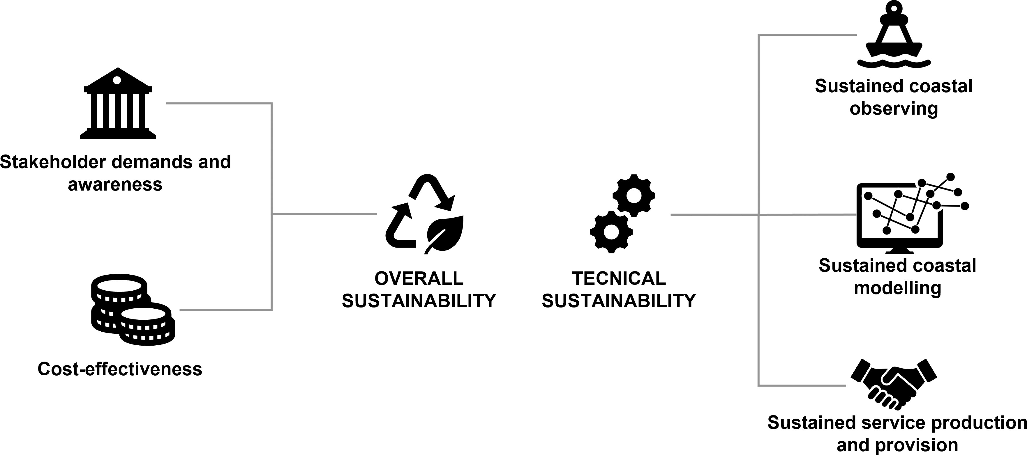
Figure 4 Factors contributing to the sustainability of coastal services.
5.1 Overall sustainability
The overall sustainability of coastal service is determined by political will and ensured by EU and, especially, national legislations, which give a mandate to one or more public and/or private institutes performing the service. With clear governmental mandates, the coastal service as a community function is sustained. Since the coastal service provides essential data and information for public safety, climate change adaptation, environmental protection, ecosystem-based management and blue economy sectors, it is natural that the service is supported at the governmental level.
Governments, when supporting the coastal service, would also require the service to be performed cost-effectively. However, the potential of coastal services is far from being fully exploited, partly due to multi-sector and multi-disciplinary features in the governance, research and development.
Due to budget constraints, governmental support can only cover part of the coastal services or some dedicated service areas e.g., storm surge. Level of the support also varies with countries, depending on the governmental strategy, especially towards Green Transition, stakeholder demands and also the capacity in a country providing such services. The more cost-effectiveness, capability and awareness on the benefit of the coastal service, the more likely the service will get governmental support. Sustainability related to these factors can be called technical sustainability.
The technical sustainability thus depends on the cost-effectiveness of the service and also the stakeholder demands and awareness. Below we analyse the technical sustainability in several areas for EuroGOOS coastal service: sustained coastal observing system, sustained coastal modelling, sustained production, sustained services, and stakeholder demands and awareness.
5.2 Sustained coastal observing
Coastal observing should fit for the purpose of national and local applications. A major deficiency of the current coastal-estuary observing system is lack of common standard and integration. Currently coastal-estuary observing is done at national level by multi-sectors, e.g. operational agency, environmental agency, fishery agency, maritime and hydrological agency, coastal guards, municipalities, research institutes and private persons and entities (private companies, NGOs, citizen science, etc). Major challenges are:
● Monitoring programs are designed separately for different purposes;
● Observations are measured with different standards;
● Spatio-temporal gaps are not sufficiently assessed and lack of solutions for filling the gaps;
● Data are managed and disseminated within different communities, thus lack of data sharing in all relevant communities.
It has never been simple to carry out multi-sector and multi-disciplinary integration in terms of governance, monitoring, R&D, production and service. Multi-dimensional integration to remove the sectorial and institutional barrier is a challenging but efficient way to improve the sustainability of coastal observing (She et al., 2019).
On-going European Ocean Observation System (EOOS) framework initiative will integrate multi-sectoral marine observations, both in open ocean and coastal waters. It is recommended that EOOS should pay special attention on integrating multi-sectoral coastal-estuary observations for the purpose of coastal service. Cost-effective, fit-for-purpose and coordinated sampling strategies should be designed to fill the gaps of coastal-estuary observing and reduce the monitoring cost and increase benefits of observations. It is recommended to use modelling and assimilation studies (OSSE and OSEs) to help improve and optimize the coastal sampling strategies.
In addition to enhanced integration and coordination, sustainability of coastal observing systems can also be improved by cost-effective monitoring technology; more efficient data sharing & integration and cost-effective sampling strategies.
Cost-effective monitoring technology: Coastal monitoring networks measure multi-disciplinary parameters in the coastal-estuary region, including river discharge of fresh water, nutrients and pollutants, water temperature, salinity, sea level, waves, currents, water quality, sediment, SPM, topography, coastal erosion, phytoplankton, zooplankton, benthic and fishery etc. Here we only focus on monitoring technology for physical parameters. As a cost-effective monitoring technology, satellite monitoring for sea level, waves, ice, SST, chl-a, optical parameters, SPM and algae in coastal-estuary waters should be enhanced. A major bottleneck is the quality and resolution of the satellite data in the shallow waters and when approaching the coasts. HF-radar is an effective tool making current measurements, thus can be widely applied in coastal monitoring. Unmanned Aerial Vehicles (UAVs) or “drones” provide an efficient and cost-effective survey tool for topographic mapping and surface parameter measurement in the coastal zone. Ferrybox has been widely used in European regional seas to provide cost-efficient monitoring on surface parameters. Water column measurements are normally monitored by moorings, research vessels and gliders/floats. In recent years, floats and gliders are more and more frequently used in coastal seas to obtain water column measurements.
Public-public partnership for data integration: operational monitoring provides high frequency measurements for sea level, temperature, salinity, waves and currents but with quite low spatial resolution. Environmental and fishery agencies observe national waters regularly with a low temporal resolution but much higher spatial coverage compared to operational monitoring. Research institutes perform research field campaigns with high quality and resolution observing. Enhanced public-public partnership is recommended to improve data sharing and accessibility, so that integrated datasets can fit for multi-purposes in operational, environmental and ecosystem applications.
Public-private partnership for data integration: in recent years observations made by citizens, NGOs and companies become more and more active in coastal sea monitoring. Ferrybox lines have been widely operated in European regional seas, as a result of successful public-private partnership in ocean monitoring. In an efficient public-private partnership, the public partners can facilitate operations of private monitoring (e.g. as national contact point, providing recommendations on optimizing sampling strategies), demonstrate the quality and usefulness of private observations, facilitate collection, dissemination and usage of private data, share and spread best practices on public-private cooperation for ocean observing; while the private partners can provide more observations either free of charge or in a cost-effective way.
5.3 Sustained coastal-estuary modelling
Systematic and long-term R&D strategy to support coastal-estuary modelling in EU and national level is a primary condition for sustained coastal-estuary modelling. Although coastal operational oceanography has been identified as one of the four priority areas of EuroGOOS research (She et al., 2016) and EuroGOOS Coastal Working Group is actively involved in promoting EuroGOOS cooperation in this area, coastal modelling is mainly focused on the coastal ocean instead of coastal-estuary area. Technically, key factors for cost-effectiveness include e.g. HPC efficiency, flexible grid for high resolution modelling, assimilation technology to integrate high resolution/frequency data with models, improved shallow water parameterization and effectively coupling between coastal-estuary-catchment-seabed. Technological challenges on HPC efficiency, flexible grid and assimilation are common issues in both coastal-estuary modelling and coastal ocean modelling, which have been addressed in She et al. (2016), and Capet et al. (2020). However, knowledge and technological gaps in resolving physical-biogeochemical processes and coastal-estuary-catchment-seabed coupling processes in coastal-estuary models are yet to be identified. Corresponding roadmap for solving these issues should be made.
5.4 Sustained service production and provision
An efficient operational platform, a system of systems, including observations, models, HPC infrastructure and operational teams, is at the core of operational coastal service provision. Among different options of data production and provision systems, operational system is prevailing with its robustness, high efficiency, quality and sustainability. The operational platform allows an operational information service, more frequent and automatic update of the service data and products and support to adaptive planning and decision-making and risk management.
Although the EuroGOOS community members have used operational approaches in generating and providing the coastal service, many other actors have not done so yet. Therefore, during future development of the coastal service, the operational approach and practices, e.g., delivery data in near real time or at right time, produce model data more frequently and regularly, integrate observations with models in an operational platform, should be promoted.
A coastal service delivers, in a timely manner, high quality data, products and information to users. According to a climate data survey in Denmark, among more than 800 entities using community climate data service, only 13 of them (i.e., 1.6%) make their own climate data (Larsen et al., 2021). This means that most users will use data products from the service provider directly. Thus, it is of high importance for the service providers to make the data products user friendly with high added-value. Such data products are called tailored products, which explicitly address user demands. To maximize their fit-for-purpose, these tailored data products should be co-designed as synergy between the data providers, the product users and the stakeholders.
A sustained service provision needs an effective business model that covers the entire value chain of the coastal service, especially as end-users can’t obviously be asked to fund the entire service provision chain. Therefore, the business plan necessarily includes (heavy) public funding at its basis (e.g. launching Sentinels). Then several layer of processing (with products getting closer and closer to “accessible services”) are gradually taken in charge by operators from public to private entities. Somewhere near the end of the processing chain, the business plan involves payment for targeted services. It is very important to clarify: At what level does this occur now? and Where should it occur to ensure sustainability?
The coastal service shall develop and provide highly value-added tailored products which meet end and intermediate user needs and highlight societal priority issues and major drivers. In addition, much less has been done in collecting information and data on the user demands and user behaviour on using coastal-estuary data and products. New, innovative business models should be developed and implemented. One example is in the field of implementing legislation of EU Directives, e.g., MSFD, WDF and national strategies for the Green Transition. Many governmental agencies, service providers and blue growth sectors have to work together. In many cases, current business model is that governmental planning tasks (e.g. Marine Spatial Planning) are contracted to external service providers on a case-by-case basis. Through developing an open and free community tailored product service, a large part of the planning can be made as internal activities within the government agencies and the general implementation plan in a given sector can be made available in national level or regional level, which is much more efficient and optimal than the current case-by-case practices (She and Murawski, 2019).
6 Actionable recommendations
Based on the above analysis, a list of key short-term or medium-term priorities to provide targeted, efficient and effective products for coastal services can be recommended:
6.1 Community and user uptake
● Identification of needs and requirements of coastal users (both intermediate and end-users);
● Sharing best practices between EuroGOOS coastal downstream services
● Integrating different coastal service components and communities through an operational approach
● Enhance surveys on user requirements and user behaviour on using community coastal-estuary data service
● Enhanced communication with wider community to increase awareness of stakeholders on EuroGOOS coastal service
● Design, develop and demonstrate innovative business models for sustained coastal service, and sharing best practices
● Design a comprehensive communication campaign to enlarge the community of coastal end users, involving policymakers, investors, ICT players, energy & utility, and other companies
● Define a roadmap with timeline and milestones including relevant large projects, technical deployments and defining an R&D agenda
● Ensure the sustainability of coastal services by making them integrated and fit-for-purpose
6.2 Technical integration
● Design new observational and computational coastal systems or evaluate the existing ones;
● Promote unified and shared components of observations and computational applications towards a common, unique and all-inclusive Coastal European Operational Oceanography system (through standards and procedures to be followed).
● Identify monitoring and observation data gaps in national waters (coastal-estuary). These gaps should be identified depending on the use (socio-economic sector) and updated on regular basis.
● Sleeping data harvesting and access through enhanced public-private and public-public partnerships
● Identify knowledge and technological gaps in coastal-estuary modelling and based on these developing coastal-estuary modelling systems to provide a seamless modelling capacity
In this context, EuroGOOS, which unites the national operational oceanography centres, could be the engine for the knowledge transfer and communication of experiences, best practices and information, not only amongst its members, but also amongst the different infrastructures, associations and agencies that have operational roles and/or interests in oceanography in Europe.
7 Discussion
The huge amount of resources invested at European level on the monitoring and understanding of the marine environment has today reached an unprecedented extent. This allowed the enhancement, or in most of the cases the creation of new monitoring and prediction systems of the state of the marine environment based on remote and in situ observations, on numerical models and on the integration of models and observations. Such great of an effort, mainly directed towards public institutions through research and development projects has prepared the terrain for a mature and structural implementation of the European core services of monitoring and forecasting of the Earth in the framework of the Copernicus Program within six different services: Marine, Land, Atmosphere, Climate Change, Emergency and Security. Coastal extension is already on the way, for instance the Copernicus Thematic Hub on coastal zones is launched in June 2023. The Copernicus Marine Service is also developing the coastal extension of their services since Dec 2022 (green light of the European Commission to do so). This coastal extension includes (i) improved and new pan-EU satellite core monitoring of coastal zones (with new products such as satellite derived bathymetry); (ii) co-design and co-production of coastal marine information with Member States systems via the National Marine Stakeholder Forum (active since Oct 2022) for a re-enforced governance, deeper interactions with Member States representatives and national entities in the marine domain; and (iii) a User engagement/national collaboration programme on coastal interfaces (on-going since May 2023), in which pilot demonstrations for coastal interfaces and monitoring will be made, incl. development of use cases/applications that support EU Policy and Environmental Directives. The main activity with respect to landward aspects undertaken in the Copernicus Marine Service is dealing with river forcings. They are strengthening their interface with CEMS and investigating the use of EFAS/GLOFAS for river discharges to force their ocean models. On this topic, they have also funded different R&D projects (2018-2020): Land-Marine Boundary Developments And Analysis (LAMBDA), Benefits Of Dynamically Modelled River Discharge Input For Ocean And Coupled Atmosphere-Land-Ocean Systems (BRONCO), Estuarine Box Model For Interfacing Rivers And Ocean (ESTUARIO), Coastal Unstructured Resolution For Aquatic Environments (CURAE).
The European Operational Oceanography and Ocean Observation landscape has radically changed after the definitive success and the sustained and regulated functioning of Copernicus and of its Core Services, which became the European Earth Observation Program, driven by the end users and ruled by the European Commission and the Member States through the User Forum and the Committee. In particular, the Copernicus Marine Service provides regional (North-East Atlantic, Arctic, Baltic, Mediterranean and Black Sea) products that provide accuracy higher than the global product, also provided by the same service. The “regionalization” of processing chains, indeed, takes into account the characteristics of each regional sea for production and data validation, improving accuracy of estimates in coastal waters. This is a very important first step for the coastal community.
The Copernicus core services are, however, not designed to cover local and very high-resolution scales which are often required for the coastal environment. Nevertheless, the advancement in technology of observing systems and in computational power for the modelling compartment allow today to achieve much more comprehensive and resolved monitoring systems of the coastal environment. In this regard, it is important that the research advancements produced by public institutions in the core framework be a booster for the downstreaming of commercial applications in a synergic technological and business model. The potential competition between the private and public sectors (research and local stakeholders) should be avoided. On the contrary, it will be important that the expertise, dynamicity and efficiency of the private sector be an added value for the coastal community in terms of services of high technological content and reliability. Furthermore, it is important to create a robust and self-sustaining ecosystem of users and stakeholders around coastal services. This means that alongside the implementation of innovative coastal services, it is important to look into the future assuring that these new services are built on solid foundations, assuring long term financial robustness and a solid user community interested in using and improving the services.
Member states have already started coordinated actions at national level in order to optimize the development and implementation of coastal services, basing the priorities on the users’ needs (e.g. Geraldini et al., 2021), in continuity with the Copernicus Services and the European Research Infrastructures. A tight and fruitful coordination between the national and European levels of the coastal services and between the main actors of the Copernicus core Services and community developed downstream services will be essential, as undertaken in the new actions of Copernicus Marine with its National Marine Stakeholder Forum and the national collaboration/user engagement programme, and as outlined in the White Paper of the Med 7 Initiative “Copernicus for the blue economy in the Mediterranean Sea and beyond” (Geraldini et al., 2021). In particular, the need for findability, availability, interoperability, reusability of the data (FAIR principle), the harmonization of local coastal products amongst neighbouring countries, the definition of a clear boundary between the segments of products free of charge and those left to the free market (commercial companies) and between base research and operational activities will be essential characteristics to be considered in the national-to-European coordination.
EuroGOOS in its capacity of enhancing cooperation and promoting the benefits of operational oceanography to ensure that sustained observations are made in Europe’s seas, underpinning a suite of fit-for-purpose products and services for marine and maritime end-users, can partly fulfil this national-to-European coordination. This activity should also be pursued, taking into strong account the role of the Copernicus Programme, the European Research Infrastructures and the general landscape of European Oceanography, where many organizations at European level (such as EMODnet, EEA, EMB) and entities and agencies at various levels play today important roles in the monitoring of the land and ocean. In this complex landscape of agencies and organisations, enhanced dialogue between the national representatives of the Copernicus Programme and the EuroGOOS members would be beneficial and desirable. The arrival of DTO concept and the arrival of the UN Ocean Decade programmes would help to develop those on a European and Global scale.
Author contributions
GE is the chair of the Coastal Working Group and the initiator of this community paper. LM consolidated and harmonised the various draft versions and coordinated the manuscript review process. EA reviewed the manuscript. Main contributors per topic: Definition of coastal services: VF, AG, AM, LM. Community benefits and user requirements: AC, MG, IF, TD, LM. Existing coastal services and gap analysis: GU, VF, VC, AC, FC. Components for coastal service provision and their integration: BM, FC, AR, CF, JoS, KB. Sustainability of coastal services: JuS, VF. All authors contributed to the article and approved the submitted version.
Funding
This work was supported by the FORCOAST project which received funding from the European Union’s Horizon 2020 research and innovation programme under grant agreement No 870465, INTERREG Atlantic Area Projects MyCOAST (EAPA 285/2016) and iFADO (EAPA 165/2016) co-funded by the ERDF (EU).
Acknowledgments
This work was initiated by the EuroGOOS Coastal Working Group and received support from the EuroGOOS board. We are grateful for EuroGOOS and its community to have enabled the writing of this paper.
Conflict of interest
Author Marcos Garcia Sotillo was employed by company Nologin Consulting S.L.,.
The remaining authors declare that the research was conducted in the absence of any commercial or financial relationships that could be construed as a potential conflict of interest.
Publisher’s note
All claims expressed in this article are solely those of the authors and do not necessarily represent those of their affiliated organizations, or those of the publisher, the editors and the reviewers. Any product that may be evaluated in this article, or claim that may be made by its manufacturer, is not guaranteed or endorsed by the publisher.
Footnotes
- ^ Services provided by the natural environment to the society, not to confound with operational services as described in Sect. 1
References
Alvarez Fanjul E., Sotillo M. G., Perez Gomez B., Garcia Valdecasas J. M., Perez Rubio S., Lorente P., et al. (2018). “Operational oceanography at the service of the ports,” in New frontiers in operational oceanography. Eds. Chassignet E., Pascual A., Tintoré J., Verron J. (Tallahassee, Florida, USA: GODAE OceanView), 729–736. doi: 10.17125/gov2018.ch27
Braga F., Scarpa G. M., Brando V. E., Manfè G., Zaggia L. (2020). COVID-19 lockdown measures reveal human impact on water transparency in the Venice lagoon. Sci. Total Environ. 736, 139612. doi: 10.1016/j.scitotenv.2020.139612
Brando V. E., Braga F., Zaggia L., Giardino C., Bresciani M., Matta E., et al. (2015). High-resolution satellite turbidity and sea surface temperature observations of river plume interactions during a significant flood event. Ocean Sci. 11, 909–920. doi: 10.5194/os-11-909-2015
Britton E., Domegan C., McHugh P. (2021). Accelerating sustainable ocean policy: the dynamics of multiple stakeholder priorities and actions for oceans and human health. Mar. Policy 124, 104333. doi: 10.1016/j.marpol.2020.104333. ISSN 0308-597X.
Bruschi A., Lisi I., De Angelis R., Querin S., Cossarini G., Di Biagio V., et al. (2021). Indexes for the assessment of bacterial pollution in bathing waters from point sources: the northern Adriatic Sea CADEAU service. J. Environ. Manage. 293, (2021). doi: 10.1016/j.jenvman.2021.112878
Capet A., Fernández V., She J., Dabrowski T., Umgiesser G., Staneva J., et al. (2020). Operational modeling capacity in European seas–an EuroGOOS perspective and recommendations for improvement. Front. Mar. Sci. 7. doi: 10.3389/fmars.2020.00129
Cesbron G., Melet A., Almar R., Lifermann A., Tullot D., Crosnier L. (2021). Pan-European satellite-derived coastal bathymetry–review, user needs and future services. Front. Mar. Sci. 8. doi: 10.3389/fmars.2021.740830
Cianelli D., Falco P., Iermano I., Mozzillo P., Uttieri M., Buonocore B., et al. (2015). Inshore/offshore water exchange in the gulf of Naples. J. Mar. Systems. 145, 37–52. doi: 10.1016/j.jmarsys.2015.01.002
Copernicus Marine Service (2022) COPERNICUS MARINE USER UPTAKE. Available at: https://marine.copernicus.eu/sites/default/files/media/pdf/2023-02/Copernicus_Marine_KPI_report_2022.pdf (Accessed 14/05/2023).
Cusack C., Dabrowski T., Lyons K., Berry A., Westbrook G., Nolan G., et al. (2016). Harmful algal bloom warning system for SW ireland. part II: ASIMUTH-tailored model products, observations. Harmful Algae 53, 86–101. doi: 10.1016/j.hal.2015.11.013
Cusack C., Silke J., Ruiz-Villarreal M., Eikrem W., Dale T., Moejes F., et al. (2018). Harmful algal bloom bulletins. AtlantOS Deliverable 6, 36. doi: 10.3289/AtlantOS_D8.6
Dale T., Cusack C., Ruiz M. (2017). Aquaculture site selection report. AtlantOS Deliverable 2, 39. doi: 10.3289/AtlantOS_D8.2
Dale T., Cusack C., Ruiz Villarreal M., Leadbetter A., Lyons K., Burke N., et al. (2018). Aquaculture operation bulletin: weather window nowcast/forecast bulletin tool for offshore aquaculture operators. AtlantOS Deliverable D8.8. doi: 10.3289/AtlantOS_D8.8
Davidson F., Alvera-Azcárate A., Barth A., Brassington G. B., Chassignet E. P., Clementi E., et al. (2019). Synergies in operational oceanography: the intrinsic need for sustained ocean observations. Front. Mar. Sci. 6. doi: 10.3389/fmars.2019.00450
De Mey-Frémaux P., Ayoub N., Barth A., Brewin R., Charria G., Campuzano F., et al. (2019). Model-observations synergy in the coastal ocean. Front. Mar. Sci. 6, 436. doi: 10.5670/oceanog.2009.76
De Mey P., Stanev E., Kourafalou V. (2017). Science in support of coastal ocean forecasting–part 1. Ocean Dynamics 67, 665–668. doi: 10.1007/s10236-017-1048-1
Díaz H., Guedes Soares C. (2020). Review of the current status, technology and future trends of offshore wind farms. Ocean Eng. 209, 107381. doi: 10.1016/j.oceaneng.2020.107381
Epelde I., Liria P., de Santiago I., Garnier R., Uriarte A., Picón A., et al. (2021). (under review) beach carrying capacity management under covid-19 era on the basque coast by means of automated coastal videometry. Ocean Coast. Manage. 208. doi: 10.1016/j.ocecoaman.2021.105588
European Commission (2009). FP7 grant agreement – annex III – specific provisions for transnational access activities. Brussels: European Commission.
Luxembourg: European Commission (2020). The EU blue economy report 2020 Vol. 18 (Luxembourg: Publications Office of the European AtlantOS). doi: 10.2771/363293
European Commission (2022). The EU blue economy report (Luxembourg: Publications Office of the European Union. Luxembourg).
Farcy P., Durand D., Charria G., Painting S. J., Tamminen T., Collingridge K., et al. (2019). Toward a European coastal observing network to provide better answers to science and to societal challenges; the JERICO research infrastructure. Front. Mar. Sci. 6. doi: 10.3389/fmars.2019.00529
Fernández F., Álvarez-Fanjul E., Delgado J., Díaz R., Valcárcel N., García-Fletcher A., et al. (2020) Data services for intermediate users at the coastal zone: analysis of gaps and recommendations for evolution from the Spanish perspective. report supporting the European environment agency’s (EEA) crosscutting coordination of the Copernicus in situ component establishing an eionet group of in situ data experts. Available at: https://insitu.copernicus.eu/library/reports/data-services-for-intermediate-users-at-the-coastal-zone-spanish-perspective.
Frigstad H., Kaste Ø, Deininger A., Kvalsund K., Christensen G., Bellerby R. G. J., et al. (2020). Influence of riverine input on Norwegian coastal systems. Front. Mar. Sci. 7. doi: 10.3389/fmars.2020.00332
Geraldini S., Bruschi A., Belloti G., Taramelli A. (2021). User needs analysis for the definition of operational coastal services. Water 13 (1), 92. doi: 10.3390/w13010092
Gunn A. G. (2007). “Radionet: advanced radio astronomy across Europe,” in Organizations and strategies in astronomy volume 7. astrophysics and space science library, vol. 343 . Ed. Heck A. (Dordrecht: Springer). doi: 10.1007/978-1-4020-5301-6_9
Heslop E., Tintoré J., Rotllan P., Alvarez-Berastegui D., Frontera B., Mourre B., et al. (2019). SOCIB integrated multi-platform ocean observing and forecasting: from ocean data to sector-focused delivery of products and services. J. Oper. Oceanogr. 12, S67–S79. doi: 10.1080/1755876X.2019.1582129
Hernández-Lasheras J., Mourre B. (2018). Dense CTD survey versus glider fleet sampling: comparing data assimilation performance in a regional ocean model west of Sardinia. Ocean Sci. 14, 1069–1084. doi: 10.5194/os-14-1069-2018
Hernández-Lasheras J., Mourre B., Orfila A., Santana A., Reyes E., Tintoré J. (2021). Evaluating high-frequency radar data assimilation impact in coastal ocean operational modelling. Ocean Sci. 17, 1157–1175. doi: 10.5194/os-17-1157-2021
IOC-UNESCO (2021). The united nations decade of ocean science for sustainable developmen-2030): implementation plan, summary (Paris: UNESCO Publishing).
IOC-UNESCO (2022). Implementing operational ocean monitoring and forecasting systems. GOOS 275, 24–37. doi: 10.48670/ETOOFS
Jacob B., Stanev E. V. (2021). Understanding the impact of bathymetric changes in the German bight on coastal hydrodynamics: one step toward realistic morphodynamic modeling. Front. Mar. Sci. 8, 640214. doi: 10.3389/fmars.2021.640214
James S. C., Zhang Y., O’Donncha F. (2018). A machine learning framework to forecast wave conditions. Coast. Eng. 137, 1–10. doi: 10.1016/j.Coastaleng.2018.03.004
Jordà G., Sanchez-Roman A., Gomis D. (2016). Reconstruction of transports through the strait of Gibraltar from limited observations. Clim. Dynam. 1–15. doi: 10.1007/s00382-016-3113-8
Kourafalou V. H., De Mey P., Le Hénaff M., Charria G., Edwards C. A., He R., et al. (2015a). Coastal ocean forecasting: system integration and validation. J. Operat. Oceanogr. 8, S127–S147. doi: 10.1080/1755876X.2015.1022336
Kourafalou V. H., De Mey P., Staneva J., Ayoub N., Barth A., Chao Y., et al. (2015b). Coastal ocean forecasting: science foundation and user benefits. J. Operat. Oceanogr. 8, S127–S147. doi: 10.1080/1755876X.2015.1022348
Lavigne H., van der Zande D., Ruddick K., Dos Santos J. C., Gohin F., Brotas V., et al. (2021). Quality-control tests for OC4, OC5 and NIR-red satellite chlorophyll-a algorithms applied to coastal waters. Remote Sens. Environ. 255, 112237. doi: 10.1016/j.rse.2020.112237
Larsen M. A. D., Karamitilios G., Halsnæs K., She J., Madsen K. S. (2021)Data driven climate change adaptation part a: Advancing future multi-sectorial climate services by mapping current usage and demand, DMI report no. 21-30, Danish meteorological institute. Available at: https://www.dmi.dk/publikationer/.
Le Traon P. Y., Reppucci A., Alvarez Fanjul E., Aouf L., Behrens A., Belmonte M., et al. (2019). From observation to information and users: the Copernicus marine service perspective. Front. Mar. Sci. 6. doi: 10.3389/fmars.2019.00234
Lett C., Verley P., Mullon C., Parada C., Brochier T., Penven P., et al. (2008). A Lagrangian tool for modelling ichthyoplankton dynamics. Environ. Model. Software 23 (9), 1210–1214. doi: 10.1016/j.envsoft.2008.02.005
Liubartseva S., Coppini G., Pinardi N., De Dominicis M., Lecci R., Turrisi G., et al. (2016). Decision support system for emergency management of oil spill accidents in the Mediterranean Sea. Nat Hazards Earth Syst. Sci. 16, 2009–2020. doi: 10.5194/nhess-16-2009-2016
Liubartseva S., Federico I., Coppini G., Lecci R. (2021). Stochastic oil spill modeling for environmental protection at the port of taranto (southern Italy). Mar. pollut. Bull. 171, 112744. doi: 10.1016/j.marpolbul.2021.112744
Macias J. C., Avila Zaragozá P., Karakassis I., Sanchez-Jerez P., Massa F., Fezzardi D., et al. (2019). Allocated zones for aquaculture: a guide for the establishment of coastale zones dedicated to aquaculture in the Mediterranean and the black Sea (Rome: General Fisheries Commission for the Mediterranean. Studies and Reviews), 90.
Mantovani C., Corgnati L. P., Horstmann J., Rubio A., Reyes E., Quentin C., et al. (2020). Best practices on high frequency radar deployment and operation for ocean current measurement. Front. Mar. Sci. - Ocean Observation. 7. doi: 10.3389/fmars.2020.00210
Manso-Narvarte I., Fredj E., Jordà G., Berta M., Griffa A., Caballero A., et al. (2020). 3D reconstruction of ocean velocity from high-frequency radar and acoustic Doppler current profiler: a model-based assessment study. Ocean Sci. 16, 575–591. doi: 10.5194/os-16-575-2020
Manso-Narvarte I., Rubio A., Jordà G., Carpenter J., Merckelbach L., Caballero A. (2021). Three-dimensional characterization of a coastal mode-water eddy from multiplatform observations and a data reconstruction method. Remote Sensing. 13 (4), 674. doi: 10.3390/rs13040674
McKinley E., Burdon D., Shellock R. J. (2022). The evolution of ocean literacy: a new framework for the united nations ocean decade and beyond. Mar. pollut. Bull. 186, 114467. doi: 10.1016/j.marpolbul.2022.114467. ISSN 0025-326X.
Mehvar S., Filatova T., Dastgheib A., De Ruyter van Steveninck E., Ranasinghe R. (2018). Quantifying economic value of coastal ecosystem services: a review. J. Mar. Sci. Engineering 6 (1), 5. doi: 10.3390/jmse6010005
Melet A., Buontempo C., Mattiuzzi M., Salamon P., Bahurel P., Breyiannis G., et al. (2021). European Copernicus Services to inform on sea-level rise adaptation: current status and perspectives. Front. Mar. Sci. 8, 703425. doi: 10.3389/fmars.2021.703425
Melet A., Teatini P., Le Cozannet G., Conversi A., Jamet C., Benveniste J., et al. (2020). Earth observations for monitoring marine coastal hazards and their drivers. Surveys Geophysics 41, 1489–1534. doi: 10.1007/s10712-020-09594-5
Melo-Merino S. M., Reyes-Bonilla H., Lira-Noriega A. (2020). Ecological niche models and species distribution models in marine environments: a literature review and spatial analysis of evidence. Ecol. Model. 415, 108837. doi: 10.1016/j.ecolmodel.2019.108837
Nechad B., Ruddick K., Schroeder T., Oubelkheir K., Blondeau-Patissier D., Cherukuru N., et al. (2015). CoastColour round robin data sets: a database to evaluate the performance of algorithms for the retrieval of water quality parameters in coastal waters. Earth system Sci. Data 7 (2), 319–348. doi: 10.5194/essdd-8-173-2015
Olmedo E., González-Haro C., Hoareau N., Umbert N., González-Gambau V., Martínez J., et al. (2020). Nine years of SMOS Sea surface salinity global maps at the Barcelona expert center. Earth Syst. Sci. Data Discuss 13 (2), 857–888. doi: 10.5194/essd-2020-232
O'Donncha F., McKenna S., Updyke T., Roarty H., Ragnoli E. (2014). "Assessment and quantification of HF radar uncertainty," Vol. pp (NL, Canada: 2014 Oceans - St. John's, St. John's), 1–10. doi: 10.1109/OCEANS.2014.7003098
Pastore V. P., Zimmerman T. G., Biswas S. K., Bianco S. (2020). Annotation-free learning of plankton for classification and anomaly detection. Sci. Rep. 10, 12142. doi: 10.1038/s41598-020-68662-3
Ponte R. M., Carson M., Cirano M., Domingues C. M., Jevrejeva S., Marcos M., et al. (2019). Towards comprehensive observing and modeling systems for monitoring and predicting regional to coastal Sea level. Front. Mar. Sci. 6. doi: 10.3389/fmars.2019.00437
Ren L., Nash S., Hartnett M. (2015). “Data assimilation with high-frequency (HF) radar surface currents at a marine renewable energy test site,” in Renewable energies offshore. Ed. Guedes Soares C. (Leiden: CRC Press/Balkema), 189–193.
Rubio A., Mader J., Corgnati L., Mantovani C., Griffa A., Novellino A., et al. (2017). HF Radar activity in European coastal seas: next steps towards a pan-European HF radar network. Front. Mar. Sci. 4. doi: 10.3389/fmars.2017.00008
Sanchez-Arcilla A., Staneva J., Cavaleri L., Badger M., Bidlot J., Sorensen J. T., et al. (2021). CMEMS-based coastal analyses: conditioning, coupling and limits for applications. Front. Mar. Sci. 8, 604741. doi: 10.3389/fmars.2021.604741
Santoro F., Santin S., Scowcroft G., Fauville G., Tuddenham P. (2018). Ocean literacy for all, a toolkit, IOC/UNESCO & UNESCO Venice office (Paris: UNESCO). doi: 10.25607/OBP-1554
Schulz-Stellenfleth J., Staneva J. (2019). A multi-collocation method for coastal zone observations with applications to sentinel-3A altimeter wave height data (15, 249-268: Ocean Sci.). doi: 10.5194/os-15-249-2019
She J., Murawski J. (2019). Developing community marine data service for blue growth sectors. J. Operational Oceanography 12:sup2, S80–S96. doi: 10.1080/1755876X.2019.1644095
She J., Allen I., Buch E., Crise A., Johannessen J. A., Traon Le, et al. (2016). Developing European operational oceanography for blue growth, climate change adaptation and mitigation, and ecosystem-based management. Ocean Sci. 12, 953–976. doi: 10.5194/os-12-953-2016
She J., Muñiz Piniella Á., Benedetti-Cecchi L., Boehme L., Boero F., Christensen A., et al. (2019). An integrated approach to coastal and biological observations. Front. Mar. Sci. 6, 314. doi: 10.3389/fmars.2019.00314
Sonnewald M., Wunsch C., Heimbach P. (2019). Unsupervised learning reveals geography of global ocean dynamical regions. Earth Space Sci. 6, 784–794. doi: 10.1029/2018EA000519
Sotillo M. G., Campuzano F., Guihou K., Lorente P., Olmedo E., Matulka A., et al. (2021). River freshwater contribution in operational ocean models along the European Atlantic façade: impact of a new river discharge forcing data on the Copernicus marine service IBI regional model solution. J. Mar. Sci. Engineering 9 (4), 401. doi: 10.3390/jmse9040401
Sotillo M. G., Cerralbo P., Lorente P., Grifoll M., Espino M., Sanchez-Arcilla A., et al. (2020). Coastal ocean forecasting in Spanish ports: the SAMOA operational service. J. Operational Oceanography 13 (1), 37–54. doi: 10.1080/1755876X.2019.1606765
Sotillo M. G., Garric G., Gasparin F., Giordan C., Gehlen M., Gregoire M. L., et al. (2019). From observation to information and users: the Copernicus marine service perspective. Front. Mar. Sci. 6. doi: 10.3389/fmars.2019.00234
Tintoré J., Pinardi N., Álvarez-Fanjul E., Aguiar E., Álvarez-Berastegui D., Bajo M., et al. (2019). Challenges for sustained observing and forecasting systems in the Mediterranean Sea. Front. Mar. Sci. 6. doi: 10.3389/fmars.2019.00568
Umgiesser G., Bajo M., Ferrarin C., Cucco A., Lionello P., Zanchettin D., et al. (2021). The prediction of floods in Venice: methods, models and uncertainty (review article). Nat. Hazards Earth Syst. Sci. 21, 2679–2704. doi: 10.5194/nhess-21-2679-2021
Vandenbulcke L., Beckers J. M., Barth A. (2017). Correction of inertial oscillations by assimilation of HF radar data in a model of the ligurian Sea. Ocean Dynamics 67, 117–135. doi: 10.1007/s10236-016-1012-5
Vergano L., Umgiesser G., Nunes P. A. L. D. (2010). An economic assessment of the impacts of the MOSE barriers on Venice port activities. Transportation Res. Part D: Transport Environ. 15 (6), 343–349. doi: 10.1016/j.trd.2010.04.001
von Schuckmann K., Holland E., Haugan P., Thomson P. (2020). Ocean science, data, and services for the UN 2030 sustainable development goals. Mar. Pol. 121, 104154. doi: 10.1016/j.marpol.2020.104154
Vos K., Splinter K. D., Harley M. D., Simmons J. A., Turner I. L. (2019). CoastSat: a Google earth engine-enabled Python toolkit to extract shorelines from publicly available satellite imagery. Environ. Model. Software 122, 104528. doi: 10.1016/j.envsoft.2019.104528
Yunus A., Masago Y., Hijioka Y. (2020). COVID-19 and surface water quality: Improved lake water quality during the lockdown. Sci. Total Environ. 731, 139012. doi: 10.1016/j.scitotenv.2020.139012
Yoo B., Kim J. (2016). Path optimization for marine vehicles in ocean currents using reinforcement learning. J. Mar. Sci. Technol. 21, 334–343. doi: 10.1007/s00773-015-0355-9
Keywords: EuroGOOS, operational oceanography, coastal services, roadmap, copernicus
Citation: El Serafy G, Mészáros L, Fernández V, Capet A, She J, Sotillo MG, Melet A, Legrand S, Mourre B, Campuzano F, Federico I, Guarnieri A, Rubio A, Dabrowski T, Umgiesser G, Staneva J, Ursella L, Pairaud I, Bruschi A, Frigstad H, Baetens K, Creach V, Charria G and Alvarez Fanjul E (2023) EuroGOOS roadmap for operational coastal downstream services. Front. Mar. Sci. 10:1177615. doi: 10.3389/fmars.2023.1177615
Received: 01 March 2023; Accepted: 31 May 2023;
Published: 11 July 2023.
Edited by:
Jose A. Jimenez, Universitat Politecnica de Catalunya, SpainReviewed by:
Manel Grifoll, Universitat Politecnica de Catalunya, SpainAndrea Taramelli, University Institute of Higher Studies in Pavia, Italy
Copyright © 2023 El Serafy, Mészáros, Fernández, Capet, She, Sotillo, Melet, Legrand, Mourre, Campuzano, Federico, Guarnieri, Rubio, Dabrowski, Umgiesser, Staneva, Ursella, Pairaud, Bruschi, Frigstad, Baetens, Creach, Charria and Alvarez Fanjul. This is an open-access article distributed under the terms of the Creative Commons Attribution License (CC BY). The use, distribution or reproduction in other forums is permitted, provided the original author(s) and the copyright owner(s) are credited and that the original publication in this journal is cited, in accordance with accepted academic practice. No use, distribution or reproduction is permitted which does not comply with these terms.
*Correspondence: Ghada El Serafy, Ghada.ElSerafy@deltares.nl