WebCAT: Piloting the Development of a Web Camera Coastal Observing Network for Diverse Applications
 Gregory Dusek1*
  Debra Hernandez2
  Mark Willis3† Jenna A. Brown4
  Joseph W. Long5 Dwayne E. Porter6
  Tiffany C. Vance7
- 1Center for Operational Oceanographic Products and Services, National Ocean Service, National Oceanic and Atmospheric Administration, Silver Spring, MD, United States
- 2Southeast Coastal Ocean Observing Regional Association, Charleston, SC, United States
- 3Surfline, Inc., Nags Head, NC, United States
- 4St. Petersburg Coastal and Marine Science Center, United States Geological Survey, Saint Petersburg, FL, United States
- 5Department of Earth and Ocean Sciences, University of North Carolina Wilmington, Wilmington, NC, United States
- 6Arnold School of Public Health, University of South Carolina, Columbia, SC, United States
- 7United States Integrated Ocean Observing System Program, National Ocean Service, National Oceanic and Atmospheric Administration, Silver Spring, MD, United States
Web cameras are transforming coastal environmental monitoring. Improvements in camera technology and image processing capabilities, paired with decreases in cost, enable widespread use of camera systems by researchers, managers and first responders for a growing range of environmental monitoring applications. Applications are related to transportation and commerce, preparedness, risk reduction and response, and stewardship of coastal resources. While web cameras are seemingly ubiquitous, operators often follow unique installation procedures and collect, store, and process imagery data in various ways. These inconsistencies significantly limit the ability for imagery data to be shared and utilized across research and operational disciplines. Similar to the early days of other remote sensing networks like High Frequency Radar, the benefits and downstream application of coastal imagery data can be greatly enhanced through centralized data access and standardization of data collection, analysis and dissemination. The NOAA National Ocean Service Web Camera Applications Testbed (WebCAT) was launched in 2017 in partnership with SECOORA, as a public-private partnership to address this coastal ocean observing standardization need. WebCAT is a pilot project relying on the private sector expertise of Surfline, Inc., to install and operate several web cameras capable of meeting the short-term needs of diverse users including NOAA, USGS, state health agencies, academia and others. The project aims to determine operational imagery collection, storage, processing, access, and archival requirements that will foster collaboration across research and operational user communities. Seven web cameras have been installed at six locations along the southeast United States coast (from Florida to North Carolina) for purposes including: counting animals on the beach and migrating right whales, identifying rip currents, validating wave runup models, and understanding human use of natural resources. Here we present a review of the state of coastal imagery data and an overview of the WebCAT project. Goals of an upcoming community workshop will also be presented along with our vision for how WebCAT can motivate a future sustained operational web camera network.
Introduction
Over the past several decades coastal imagery has become a proven and invaluable tool for remote sensing of the coastal environment. Uses for imagery data range from coastal morphological change, to surf zone hydrodynamics, to beach attendance and safety, and even to detecting marine debris. Fixed position cameras for scientific coastal monitoring have been in use since the 1980s with the Argus systems the most well-known and utilized (Holman and Stanley, 2007), along with several other systems and approaches (Pearre and Puleo, 2009; Nieto et al., 2010; Brignone et al., 2012; Taborda and Silva, 2012). These systems typically consist of one or more stationary cameras at well elevated positions with a wide field-of-view, onsite computer for image processing and file transfer, and a set of algorithms that use individual pixels or groups of pixels for monitoring coastal features and processes. Although use of these types of systems have expanded as cameras have become smaller and more cost effective, there are challenges preventing widespread installation. These challenges include difficulties in finding suitable site infrastructure or an appropriate host; expertise needed for system installation and data processing; and costs associated with system installation, operation and maintenance.
Web cameras (sometimes called surfcams or webcams) have emerged as a potential alternative or complement to coastal imagery systems established for scientific use. Webcams are small, stand-alone and relatively inexpensive camera systems, which may have either remote or onsite data acquisition, processing, and analysis. A typical webcam installation consists of a single robotic pan-tilt-zoom camera, which can rotate to provide the field-of-view range of a multi-camera system. Webcams are already widely used for a range of activities including observing surf conditions, news and weather reporting, beach safety, and monitoring recreational beach use. Due to these use cases, an extensive network of coastal webcams already exists. For instance, there are over 500 cams on the Surfline network alone1. Researchers relied on a similarly extensive network in Australia to investigate webcam use for wave observations and shoreline monitoring (Splinter et al., 2011; Mole et al., 2013; Bracs et al., 2016), and were able to demonstrate acceptable shoreline monitoring performance. Though researchers in the United States have begun to install and utilize webcams for similar research objectives, more standardized use of webcam infrastructure and resulting downstream imagery products has yet to be realized.
Here we present the Web Camera Application Testbed (WebCAT), a public-private partnership to develop a sustained operational webcam network with standardized imagery data acquisition and processing for a range of downstream applications. The testbed relies on the private sector expertise of Surfline, Inc., to install and operate seven webcams at six locations along the United States southeast Atlantic and Gulf coasts (Figure 1), and partners with the National Oceanic and Atmospheric Administration (NOAA) National Ocean Service (NOS) and National Weather Service (NWS), the Southeast Coastal Ocean Observing Regional Association (SECOORA), the United States Geological Survey (USGS), and academic and state partners to store, process, and analyze the imagery data. The installation locations for the testbed were selected based on the availability of suitable installation infrastructure and initial research use cases. The initial use cases identified include: observations of coastal hazards (e.g., rip currents and wave runup), identification of both beach and marine fauna (e.g., right whales), and assessing human use of natural resources, though potential uses are likely much broader.
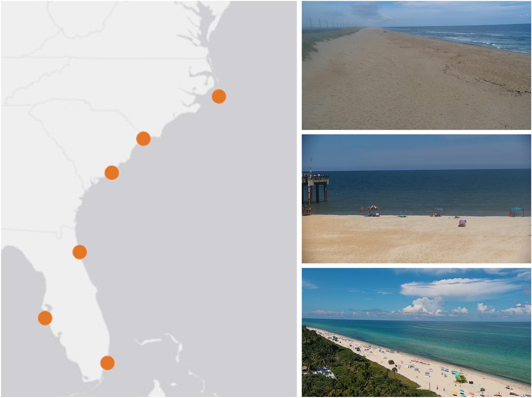
Figure 1. The six pilot WebCAT webcam locations (left) and example snapshots from the webcams in Buxton, NC (top right), St. Augustine Pier, FL (middle right) and Miami, FL (bottom right). The other webcam locations (not shown) include North Myrtle Beach, SC, Folly Beach, SC, and Bradenton, FL.
This initial pilot project is a proof-of-concept for both the public-private partnership model and for the standardization of webcam imagery data acquisition, processing, storage and delivery. As a model for success, one needs to look no further than High Frequency (HF) Radar. The HF Radar national network is a coastal ocean current remote sensing network which initially started as an academic research endeavor in the 1990s and now consists of a nationwide operational network of more than 100 radars (Harlan et al., 2010). Users can access near real-time ocean surface current data via the network in a standard format for any location across the United States, thus enabling widespread downstream use of HF Radar data. A similar potential exists for coastal webcam imagery data; webcams operated by private industry, academic, federal, regional or local partners share standardized imagery data with a regional (e.g., SECOORA, other IOOS regional associations) or federal (NOAA and USGS) centralized repository. Single site access to standardized coastal imagery data has the potential to spark innovation beyond traditional research applications to the realm of widespread operational use.
This paper will first describe the broad range of applications that have utilized coastal imagery data. The WebCAT network and methodology will then be described along with descriptions of initial applications. Lastly, both near-term (months to years) and long-term (years to decades) goals for WebCAT will be presented.
Imagery to Monitor the Coastal Environment
Over the past several decades coastal imagery data has been used for a wide range of research applications. Imagery data related to hydrodynamics and morphodynamics has been predominantly acquired and processed via the well-established Argus camera systems (Holman and Stanley, 2007; Holman and Haller, 2013), though more recently other camera or webcam systems have been utilized for coastal monitoring. The uses for coastal imagery can be broken into categories of coastal morphological change, hydrodynamics, human impact on coastal resources, and ecological, environmental and water quality observations.
Coastal Morphological Change
Perhaps the most widespread and studied use of coastal imagery data is to observe and measure coastal morphological change. Some initial uses of Argus imagery quantified sandbar morphology using time-averaged (i.e., time-exposure) imagery (Lippmann and Holman, 1989; van Enckevort and Ruessink, 2003). As described in Holman and Stanley (2007), averaging 10 min of individual surf zone images captured every 2 Hz produces an image where bright intensity pixels indicate waves consistently breaking and denote shallow water, and dark intensity pixels indicate the absence of breaking waves and relatively deeper water (Figure 2). Non-moving features appear as they do in a snapshot. A time series of these time-exposure images over days to years demonstrates changing surf zone morphology including the presence of sand bars and rip current channels.
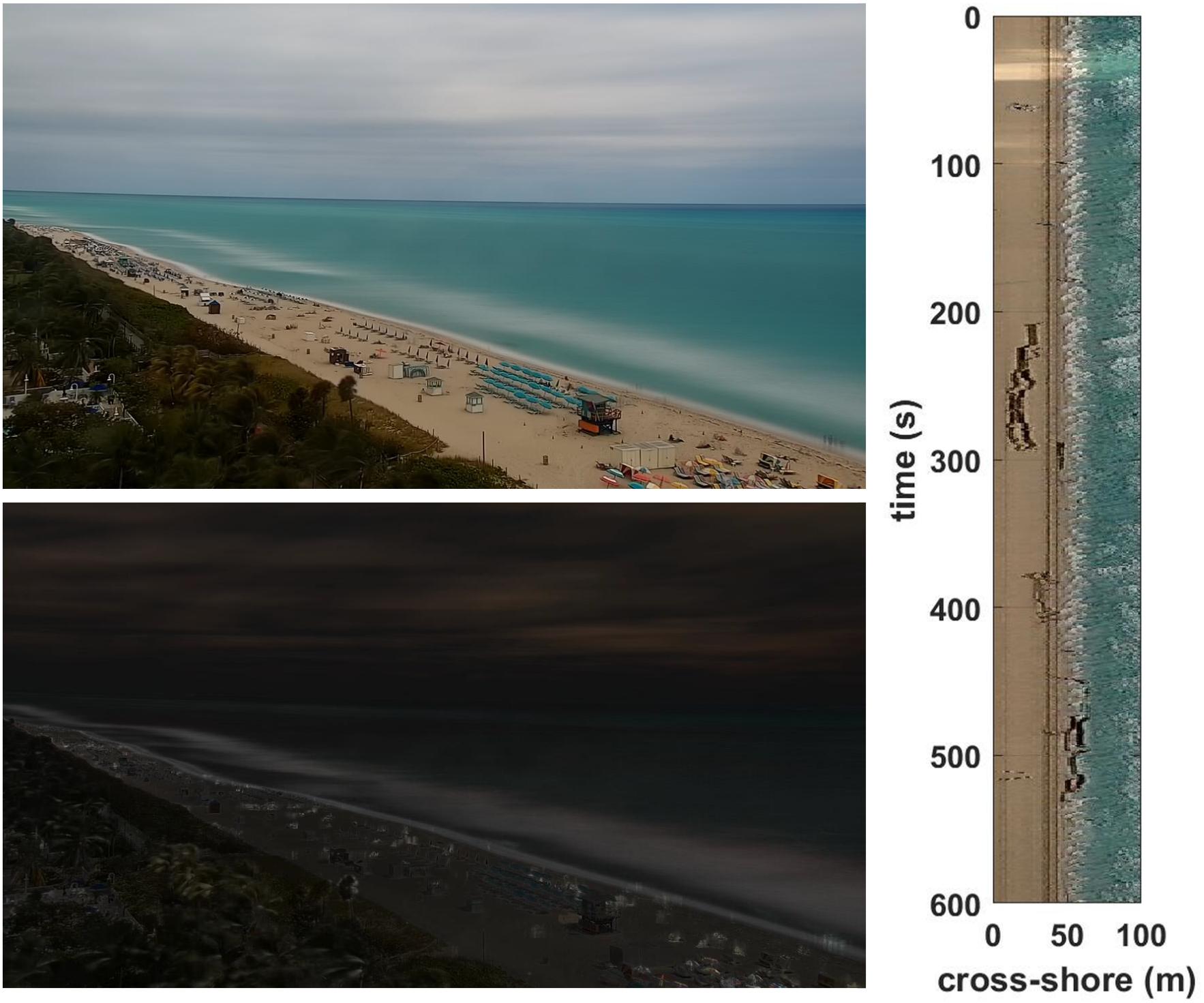
Figure 2. An example time-exposure (top), time-variance (bottom) and time-stack (right) imagery from the Miami, FL webcam at 1200 UTC on March 10, 2018. Note the white pixels varying along the beach that indicate where waves are breaking in the time-exposure image.
Imagery data has also been frequently used for the identification and quantification of shoreline change (Aarninkhof et al., 2003; Plant et al., 2007; Pearre and Puleo, 2009; Harley et al., 2014; Pianca et al., 2015; Didier et al., 2017). Typically this involves utilizing the time-exposure imagery and relying on image characteristics such as pixel brightness and pixel color to identify the shoreline position, which can then be tracked over time.
Measuring surf zone bathymetry is another application of coastal imagery data that has seen recent advancements. Beyond the more qualitative assessments enabled by time-exposure imagery, assimilation of imagery into a numerical model has produced reasonably accurate estimates of the surf zone bathymetry (van Dongeren et al., 2008). The algorithm cBathy (Holman et al., 2013), tracks wave crests in imagery over time to inversely determine depth from the dispersion relation of waves in intermediate or shallow water. The approach is accurate and robust compared to vessel-based surveys during relatively low wave height conditions (Brodie et al., 2018). Imagery derived bathymetry has also been assimilated into hydrodynamic models to predict nearshore circulation and flow features like rip currents (Wilson et al., 2014).
Hydrodynamics
Rip currents are a fundamental surf zone circulation feature that are important to observe due to the hazard posed to swimmers. Rip currents (or more precisely rip current channels) can be observed in time-exposure imagery as darker pixels extending through the region of brighter pixels denoting waves breaking over a sandbar (Lippmann and Holman, 1989). Rip current occurrence has been quantified over space and time for different coastal locations using this approach (Holman et al., 2006; Turner et al., 2007). Non-stationary or transient rips (i.e., not forced by the surf zone bathymetry) have been similarly observed by relying on alongshore variations in the time-variance imagery (Long and Ozkan-Haller, 2016). Attempts have also been made to automate the identification of rip currents in time-exposure imagery (Pitman et al., 2016).
Additional information about surf zone circulation and flow can be observed by tracking foam on the surface of the water using imagery time series. For instance, the flow speed of longshore currents can be measured by tracking the temporal and alongshore position of foam (Chickadel et al., 2003; Almar et al., 2016). Though computationally intensive, some progress has been made on utilizing the two dimensional motion of foam and other particles through particle image velocimetry (PIV). This approach has observed both swash (Holland et al., 2001) and surf zone current velocity fields (Puleo et al., 2003). More recently a similar approach known as optical flow estimation has observed flow fields in the surf zone with some skill compared to in situ observations (Derian and Almar, 2017).
In addition to currents, coastal imagery has been used to observe wave characteristics. Wave runup, or the time-varying, shoreward extent of breaking waves at the shoreline, is typically observed using time-stacks of imagery data (Figure 2; Holman and Guza, 1984; Holland et al., 1995; Stockdon et al., 2006). This approach tracks the maximum landward extent of wave runup at one alongshore location over time, and can help explain storm-induced morphological change including beach and dune erosion and overwash. Progress has also been made in measuring wave characteristics from surf zone imagery. Wave period and peak wave direction can be estimated (Herbers and Guza, 1990; Stockdon and Holman, 2000), but the ability to measure wave height has been limited, and typically requires multiple-cameras for stereo imaging (Bechle and Wu, 2011; de Vries et al., 2011; Shand et al., 2012). Lastly, other hydrodynamic topics explored via imagery data include observing internal waves (Suanda et al., 2014) and tracking movement of coastal sea ice (Druckenmiller et al., 2009).
Human Impact on Coastal Resources
Coastal imagery has also been widely used outside of the realm of physical processes. Perhaps most common is the use of imagery to identify and quantify beach users for the purposes of coastal zone management. This typically involves the development of an automated person counting method, which is then applied to a coastal region to analyze beach use over time (Green et al., 2005; Guillen et al., 2008; Balouin et al., 2014). Preferred locations of beach users can also be assessed to determine association with potential hazards (Silva-Cavalcanti et al., 2018) and to support beach management by relating use to beach carrying capacity (Jimenez et al., 2007; Cisneros et al., 2016). Marine debris or beach litter can also be identified and spatially and temporally tracked using imagery (Kako et al., 2010; Kataoka et al., 2012). Debris on the beach were identified based on pixel color and the relative differences from the surrounding beach or coastal background. Physical mechanisms leading to debris occurrence and position on the beach has been established (Kako et al., 2018).
Ecological, Environmental and Water Quality Observations
Though coastal applications are thus far limited, recent efforts have demonstrated the ecological and environmental monitoring capabilities of webcam or other stationary imagery (Bradley and Clarke, 2011). These include quantifying the increases in forested extent for an alpine treeline ecotone (Roush et al., 2007), monitoring deciduous autumnal color change (Astola et al., 2008), calculating normalized snow indices from ground-based cameras (Hinkler et al., 2002), comparing the “green-up” signal to canopy photosynthesis data (Richardson et al., 2007, 2009), and tracking the development of invasive Pepperweed (Sonnentag et al., 2011). Though not relying on a webcam, a smartphone camera app has been developed and tested to perform above water observations of water quality including suspended sediment, chlorophyll and dissolved organic matter (Leeuw and Boss, 2018). Presumably webcams could be used for similar types of observations.
The Web Camera Application Testbed
The WebCAT was initiated to meet short-term coastal observation needs and to pilot a proposed model for a public-private partnership to develop a web camera observation network. As described above, coastal imagery data is widely used for a range of applications in the research community. However, data acquisition, delivery and processing varies depending on the camera type, operator and end use. WebCAT seeks to standardize these aspects of the collection of coastal webcam imagery to maximize data access and the benefit for a range of end use applications. The observation needs initially identified include observing and quantifying wave runup, rip current occurrence, beach use and counting fauna on land and in the ocean. These use cases, coupled with existing infrastructure and host availability largely dictated the locations for camera installation (Figure 1 and Table 1). The camera installation and data acquisition was handled by Surfline, Inc., and their expertise and pre-existing infrastructure minimized cost and made the process much more efficient than it would have been otherwise. SECOORA and Axiom utilized their existing web services to host the near real-time and archived imagery data and developed a site to deliver the data to end users2. The data page includes denoting camera downtime, which can occur for a variety of reasons including camera malfunction (there were several lightning strikes at the Miami camera), as well as modifications or errors in the data transmission system. Data users such as NOAA, USGS and academic partners are applying downstream processing methods for specific end use applications.
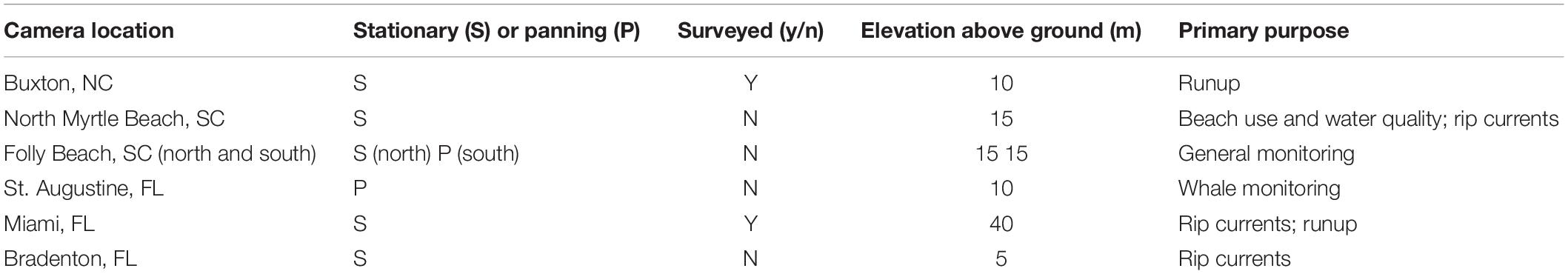
Table 1. WebCAT camera specific information and metadata.
Surfline installed seven webcams for the WebCAT project. After an initial prioritization process with the stakeholders, Surfline spent several months searching for suitable hosts. Site reviews were conducted at each location to ensure suitability for the project. Host agreements were made with property owners of each location, which outline privacy, liability, right to terminate and other considerations. High Definition PTZ IP cameras were installed at each site with a minimum imagery resolution of 1280 × 720, a sampling rate of 30 Hz (or frames per second) and a bitrate of 1500 kbps. Imagery data was made operational via existing Surfline processes and technologies. For example, Surfline already stores camera streams on Amazon Web Services (AWS) to allow their users access to the data in ten minute increments. This process was replicated for these installations, and data access was provided to Axiom who in turn made archived imagery data available to project stakeholders. In addition, Surfline had existing processes to share live streams of their cams with partners, which allowed seamless syndication of the cams on the SECOORA WebCAT website. In addition, site surveys and additional calibrations were performed at two locations (Buxton, NC and Miami, FL) to aid in converting image coordinates to real world coordinates. Standard practice for converting to real world coordinates includes intrinsic calibrations, which account for lens distortion, and extrinsic calibrations, which account for camera position and look angles, and applying standard photogrammetric relationships (Holland et al., 1997).
Several cameras (initially Miami, FL and Bradenton, FL) will be used to aid in rip current identification and were selected in part because a NOAA rip current forecast model is being validated at those locations (Dusek and Seim, 2013). Initially the time-exposure imagery will be utilized to manually identify rip currents during select time periods, however, approaches to identify rip currents in an automated or machine learning approach are also being explored. Images from select cameras with sufficiently high viewpoints and camera calibration measurements (Miami, FL and Buxton, NC) are being used to create wave runup time-stacks for extracting water levels at the shoreline and validating total water level models3. Imagery is also being used as a means to count and inventory items and activities along swimming beaches and the nearshore. Explorations include automated identification and counting of pets and birds, which may be correlated to bacterial loading and corresponding swimming beach water quality forecasts. Similarly, identification and monitoring of St. Augustine-based migrating right whales will enable the correlation of imagery-based and in-person sightings.
There were some challenges in developing the pilot WebCAT network. Finding a suitable host for new camera installations was particularly difficult. This is a common issue with camera installation, as private businesses and residences are often hesitant to participate. In some cases, this challenge resulted in camera locations, and particularly camera elevations, being less than ideal for some applications. Another challenge was installing the camera to meet the broadest range of needs for each installation. For applications where camera stability isn’t as important (e.g., counting people or animals), a panning camera is preferred to maximize field-of-view. However, for applications where stability is essential (e.g., wave runup calculations) a panning camera potentially introduces more error than is desirable (Bracs et al., 2016).
A Future Operational Web Camera Observing System
The WebCAT project will focus on continuing to enhance standardized data delivery over the near-term. For instance, investigating how best to include the downstream processing common in other scientific monitoring stations including time-exposure images, variance images and time-stacks as part of standard imagery products accessible to end users. One potential approach is to process imagery in near real-time, as each 10-min video segment is available for download. Users could then download only the processed images, potentially including rectified imagery where possible, instead of having to download the full video and perform this processing locally. An important consideration when standardizing and optimizing how to deliver webcam coastal imagery data is coordinating the needs of both the established coastal imagery research community and operational end users (e.g., NOAA, USGS, etc.). A recent coastal webcam workshop brought these user groups together to identify and document universal requirements and best practices for webcam installation, imagery acquisition, delivery, and processing. Further, it is envisioned that an ongoing community of practice will be initiated to ensure the processes, successes and lessons learned are carried forward beyond the initial WebCAT pilot.
In the long-term the WebCAT project lays the groundwork for a potential future nationwide webcam coastal ocean observing network. Similar to the HF Radar network and other national coastal observing networks, it is envisioned that common data collection and QA/QC procedures (IOOS, 2016) and data and metadata formats will be followed by all systems existing within the network. This standardization will enable the imagery data to be provided through regional hubs or websites of individual institutions or providers while also being available through a national centralized repository. This standardization will also ensure that a data user can easily access high quality imagery data for their specific application from potentially hundreds of different coastal locations throughout the United States regardless of the webcam operator. However, unlike other coastal observing networks the relatively low costs associated with webcam installation, operation and maintenance will equate to a wide range of data providers including federal, private (e.g., Surfline), academic, regional (SECOORA) and local partners. If this vision is achieved, webcam coastal imagery will transform environmental monitoring along our coastlines.
Author Contributions
GD was the primary author. DH was the project lead and contributed to the text. MW was the webcam lead and contributed to the text. JB created Figure 2 and contributed to the text. JL and DP provided the references and contributed to the text. TV contributed to the text and reviewed.
Conflict of Interest Statement
The authors declare that the research was conducted in the absence of any commercial or financial relationships that could be construed as a potential conflict of interest.
Footnotes
References
Aarninkhof, S. G. J., Turner, I. L., Dronkers, T. D. T., Caljouw, M., and Nipius, L. (2003). A video-based technique for mapping intertidal beach bathymetry. Coast. Eng. 49, 275–289. doi: 10.1016/S0378-3839(03)00064-64
Almar, R., Larnier, S., Castelle, B., Scott, T., and Floc’h, F. (2016). On the use of the Radon transform to estimate longshore currents from video imagery. Coast. Eng. 114, 301–308. doi: 10.1016/j.coastaleng.2016.04.016
Astola, H., Molinier, M., Mikkola, T., and Kubin, E. (2008). “Web cameras in automatic autumn colour monitoring,” in Proceedings of the IEEE International Geoscience and Remote Sensing Symposium, (Boston, MA: IEEE), 824–827.
Balouin, Y., Rey-Valette, H., and Picand, P. A. (2014). Automatic assessment and analysis of beach attendance using video images at the Lido of Sete beach, France. Ocean Coast. Manag. 102, 114–122. doi: 10.1016/j.ocecoaman.2014.09.006
Bechle, A. J., and Wu, C. H. (2011). Virtual wave gauges based upon stereo imaging for measuring surface wave characteristics. Coast. Eng. 58, 305–316. doi: 10.1016/j.coastaleng.2010.11.003
Bracs, M. A., Turner, I. L., Splinter, K. D., Short, A. D., Lane, C., Davidson, M. A., et al. (2016). Evaluation of opportunistic shoreline monitoring capability utilizing existing “Surfcam” infrastructure. J. Coast. Res. 32, 542–554. doi: 10.2112/Jcoastres-D-14-00090.1
Bradley, E. S., and Clarke, K. C. (2011). Outdoor webcams as geospatial sensor networks: challenges, issues and opportunities. Cartogr. Geogr. Inf. Sci. 38, 3–19. doi: 10.1559/152304063813
Brignone, M., Schiaffino, C. F., Isla, F. I., and Ferrari, M. (2012). A system for beach video-monitoring: beachkeeper plus. Comput. Geosci. 49, 53–61. doi: 10.1016/j.cageo.2012.06.008
Brodie, K. L., Palmsten, M. L., Hesser, T. J., Dickhudt, P. J., Raubenheimer, B., Ladner, H., et al. (2018). Evaluation of video-based linear depth inversion performance and applications using altimeters and hydrographic surveys in a wide range of environmental conditions. Coast. Eng. 136, 147–160. doi: 10.1016/j.coastaleng.2018.01.003
Chickadel, C. C., Holman, R. A., and Freilich, M. H. (2003). An optical technique for the measurement of longshore currents. J. Geophys. Res. Ocean 108:3364. doi: 10.1029/2003jc001774
Cisneros, M. A. H., Sarmiento, N. V. R., Delrieux, C. A., Piccolo, M. C., and Perillo, G. M. E. (2016). Beach carrying capacity assessment through image processing tools for coastal management. Ocean Coast. Manag. 130, 138–147. doi: 10.1016/j.ocecoaman.2016.06.010
de Vries, S., Hill, D. F., de Schipper, M. A., and Stive, M. J. F. (2011). Remote sensing of surf zone waves using stereo imaging. Coast. Eng. 58, 239–250. doi: 10.1016/j.coastaleng.2010.10.004
Derian, P., and Almar, R. (2017). Wavelet-based optical flow estimation of instant surface currents from shore-based and UAV videos. IEEE Trans. Geosci. Remote Sens. 55, 5790–5797. doi: 10.1109/Tgrs.2017.2714202
Didier, D., Bernatchez, P., Augereau, E., Caulet, C., Dumont, D., Bismuth, E., et al. (2017). LiDAR validation of a video-derived beachface topography on a tidal flat. Remote Sens. 9:826. doi: 10.3390/rs9080826
Druckenmiller, M. L., Eicken, H., Johnson, M. A., Pringle, D. J., and Williams, C. C. (2009). Toward an integrated coastal sea-ice observatory: system components and a case study at Barrow, Alaska. Cold Reg. Sci. Technol. 56, 61–72. doi: 10.1016/j.coldregions.2008.12.003
Dusek, G., and Seim, H. (2013). A probabilistic rip current forecast model. Journal of Coastal Research 29, 909–925. doi: 10.2112/Jcoastres-D-12-00118.1
Green, S., Blumenstein, M., Browne, M., and Tomlinson, R. (2005). “The detection and quantification of persons in cluttered beach scenes using neural network-based classification,” in Proceedings of the ICCIMA 2005: Sixth International Conference on Computational Intelligence and Multimedia Applications, (Las Vegas, NV: IEEE), 303–308.
Guillen, J., Garcia-Olivares, A., Ojeda, E., Osorio, A., Chic, O., and Gonzalez, R. (2008). Long-term quantification of beach users using video monitoring. J. Coast. Res. 24, 1612–1619. doi: 10.2112/07-0886.1
Harlan, J., Terrill, E., Hazard, L., Keen, C., Barrick, D., Whelan, C., et al. (2010). The integrated ocean observing system high-frequency radar network: status and local, regional, and national applications. Mar. Technol. Soc. J. 44, 122–132. doi: 10.4031/Mtsj.44.6.6
Harley, M. D., Andriolo, U., Armaroli, C., and Ciavola, P. (2014). Shoreline rotation and response to nourishment of a gravel embayed beach using a low-cost video monitoring technique: San Michele-Sassi Neri, Central Italy. J. Coast. Conserv. 18, 551–565. doi: 10.1007/s11852-013-0292-x
Herbers, T. H. C., and Guza, R. T. (1990). Estimation of directional wave spectra from multicomponent observations. J. Phys. Oceanogr. 20, 1703–1724. doi: 10.1175/1520-04851990020<1703:Eodwsf<2.0.Co;2
Hinkler, J., Pedersen, S. B., Rasch, M., and Hansen, B. U. (2002). Automatic snow cover monitoring at high temporal and spatial resolution, using images taken by a standard digital camera. Int. J. Remote Sens. 23, 4669–4682. doi: 10.1080/01431160110113881
Holland, K. T., Holman, R. A., Lippmann, T. C., Stanley, J., and Plant, N. (1997). Practical use of video imagery in nearshore oceanographic field studies. IEEE J. Ocean. Eng. 22, 81–92. doi: 10.1109/48.557542
Holland, K. T., Puleo, J. A., and Kooney, T. N. (2001). Quantification of swash flows using video-based particle image velocimetry. Coast. Eng. 44, 65–77. doi: 10.1016/S0378-3839(01)00022-29
Holland, K. T., Raubenheimer, B., Guza, R. T., and Holman, R. A. (1995). Runup kinematics on a natural beach. J. Geophys. Res. Ocean 100, 4985–4993. doi: 10.1029/94jc02664
Holman, R., and Haller, M. C. (2013). Remote Sensing of the Nearshore. Ann. Rev. Mar. Sci. 5 5, 95–113. doi: 10.1146/annurev-marine-121211-172408
Holman, R., Plant, N., and Holland, T. (2013). cBathy: a robust algorithm for estimating nearshore bathymetry. J. Geophys. Res. Ocean 118, 2595–2609. doi: 10.1002/jgrc.20199
Holman, R. A., and Guza, R. T. (1984). Measuring run-up on a natural beach. Coast. Eng. 8, 129–140. doi: 10.1016/0378-3839(84)90008-90005
Holman, R. A., and Stanley, J. (2007). The history and technical capabilities of Argus. Coast. Eng. 54, 477–491. doi: 10.1016/j.coastaleng.2007.01.003
Holman, R. A., Symonds, G., Thornton, E. B., and Ranasinghe, R. (2006). Rip spacing and persistence on an embayed beach. J. Geophys. Res. Ocean 111:C01006. doi: 10.1029/2005jc002965
IOOS (2016). Manual for Real-Time Quality Control of High Frequency Radar Surface Current Data: A Guide to Quality Control and Quality Assurance of High Frequency Radar Surface Currents Data Observations. Silver Spring, MD: U.S. Integrated Ocean Observing System.
Jimenez, J. A., Osorio, A., Marino-Tapia, I., Davidson, M., Medina, R., Kroon, A., et al. (2007). Beach recreation planning using video-derived coastal state indicators. Coast. Eng. 54, 507–521. doi: 10.1016/j.coastaleng.2007.01.012
Kako, S., Isobe, A., Kataoka, T., Yufu, K., Sugizono, S., Plybon, C., et al. (2018). Sequential webcam monitoring and modeling of marine debris abundance. Mar. Pollut. Bull. 132, 33–43. doi: 10.1016/j.marpolbul.2018.04.075
Kako, S., Isobe, A., and Magome, S. (2010). Sequential monitoring of beach litter using webcams. Mar. Pollut. Bull. 60, 775–779. doi: 10.1016/j.marpolbul.2010.03.009
Kataoka, T., Hinata, H., and Kako, S. (2012). A new technique for detecting colored macro plastic debris on beaches using webcam images and CIELUV. Mar. Pollut. Bull. 64, 1829–1836. doi: 10.1016/j.marpolbul.2012.06.006
Leeuw, T., and Boss, E. (2018). The hydrocolor app: above water measurements of remote sensing reflectance and turbidity using a smartphone camera. Sensors 18, E256. doi: 10.3390/s18010256
Lippmann, T. C., and Holman, R. A. (1989). Quantification of sand-bar morphology - a video technique based on wave dissipation. J. Geophys. Res. Ocean 94, 995–1011. doi: 10.1029/JC094iC01p00995
Long, J. W., and Ozkan-Haller, H. T. (2016). Forcing and variability of nonstationary rip currents. J. Geophys. Res. Ocean 121, 520–539. doi: 10.1002/2015jc010990
Mole, M. A., Mortlock, T. R. C., Turner, I. L., Goodwin, I. D., Splinter, K. D., and Short, A. D. (2013). Capitalizing on the surfcam phenomenon: a pilot study in regional-scale shoreline and inshore wave monitoring utilizing existing camera infrastructure. J. Coast. Res. 2, 1433–1438. doi: 10.2112/Si65-242.1
Nieto, M. A., Garau, B., Balle, S., Simarro, G., Zarruk, G. A., Ortiz, A., et al. (2010). An open source, low cost video-based coastal monitoring system. Earth Surf. Process. Landf. 35, 1712–1719. doi: 10.1002/esp.2025
Pearre, N. S., and Puleo, J. A. (2009). Quantifying seasonal shoreline variability at rehoboth beach, delaware, using automated imaging techniques. J. Coast. Res. 25, 900–914. doi: 10.2112/08-1029.1
Pianca, C., Holman, R., and Siegle, E. (2015). Shoreline variability from days to decades: results of long-term video imaging. J. Geophys. Res. Ocean 120, 2159–2178. doi: 10.1002/2014jc010329
Pitman, S., Gallop, S. L., Haigh, I. D., Mahmoodi, S., Masselink, G., and Ranasinghe, R. (2016). Synthetic imagery for the automated detection of rip currents. J. Coast. Res. 75, 912–916. doi: 10.2112/Si75-183.1
Plant, N. G., Aarninkhof, S. G. J., Turner, I. L., and Kingston, K. S. (2007). The performance of shoreline detection models applied to video imagery. J. Coast. Res. 23, 658–670. doi: 10.2112/1551-5036(2007)23%5B658:tposdm%5D2.0.co;2
Puleo, J. A., Farquharson, G., Frasier, S. J., and Holland, K. T. (2003). Comparison of optical and radar measurements of surf and swash zone velocity fields. J. Geophys. Res. Ocean 108:3100.
Richardson, A. D., Braswell, B. H., Hollinger, D. Y., Jenkins, J. P., and Ollinger, S. V. (2009). Near-surface remote sensing of spatial and temporal variation in canopy phenology. Ecol. Appl. 19, 1417–1428. doi: 10.1890/08-2022.1
Richardson, A. D., Jenkins, J. P., Braswell, B. H., Hollinger, D. Y., Ollinger, S. V., and Smith, M. L. (2007). Use of digital webcam images to track spring green-up in a deciduous broadleaf forest. Oecologia 152, 323–334. doi: 10.1007/s00442-006-0657-z
Roush, W., Munroe, J. S., and Fagre, D. B. (2007). Development of a spatial analysis metho using ground-based repeat photography to detect changes in the alpine treeline ecotone, Glacier National Park, Montana, USA. Arctic Antarctic Alpine Res. 39, 297–308. doi: 10.1657/1523-0430(2007)39%5B297:doasam%5D2.0.co;2
Shand, T. D., Bailey, D. G., and Shand, R. D. (2012). Automated detection of breaking wave height using an optical technique. J. Coast. Res. 28, 671–682. doi: 10.2112/Jcoastres-D-11-00105.1
Silva-Cavalcanti, J. S., Costa, M. F., and Pereira, P. S. (2018). Rip currents signaling and users behaviour at an overcrowded urban beach. Ocean Coast. Manag. 155, 90–97. doi: 10.1016/j.ocecoaman.2018.01.031
Sonnentag, O., Detto, M., Vargas, R., Ryu, Y., Runkle, B. R. K., Kelly, M., et al. (2011). Tracking the structural and functional development of a perennial pepperweed (Lepidium latifolium L.) infestation using a multi-year archive of webcam imagery and eddy covariance measurements. Agric. For. Meteorol. 151, 916–926. doi: 10.1016/j.agrformet.2011.02.011
Splinter, K. D., Strauss, D. R., and Tomlinson, R. B. (2011). Assessment of post-storm recovery of beaches using video imaging techniques: a case study at gold coast, Australia. IEEE Trans. Geosci. Remote Sens. 49, 4704–4716. doi: 10.1109/Tgrs.2011.2136351
Stockdon, H. F., and Holman, R. A. (2000). Estimation of wave phase speed and nearshore bathymetry from video imagery. J. Geophys. Res. Ocean 105, 22015–22033. doi: 10.1029/1999jc000124
Stockdon, H. F., Holman, R. A., Howd, P. A., and Sallenger, A. H. (2006). Empirical parameterization of setup, swash, and runup. Coast. Eng. 53, 573–588. doi: 10.1016/j.coastaleng.2005.12.005
Suanda, S. H., Barth, J. A., Holman, R. A., and Stanley, J. (2014). Shore-based video observations of nonlinear internal waves across the inner shelf. J. Atmos. Ocean. Technol. 31, 714–728. doi: 10.1175/Jtech-D-13-00098.1
Taborda, R., and Silva, A. (2012). COSMOS: a lightweight coastal video monitoring system. Comput. Geosci. 49, 248–255. doi: 10.1016/j.cageo.2012.07.013
Turner, I. L., Whyte, D., Ruessink, B. G., and Ranasinghe, R. (2007). Observations of rip spacing, persistence and mobility at a long, straight coastline. Mar. Geol. 236, 209–221. doi: 10.1016/j.margeo.2006.10.029
van Dongeren, A., Plant, N., Cohen, A., Roelvink, D., Haller, M. C., and Catalan, P. A. (2008). Beach wizard: nearshore bathymetry estimation through assimilation of model computations and remote observations. Coast. Eng. 55, 1016–1027. doi: 10.1016/j.coastaleng.2008.04.011
van Enckevort, I. M. J., and Ruessink, B. G. (2003). Video observations of nearshore bar behaviour. Part 1: alongshore uniform variability. Cont. Shelf Res. 23, 501–512. doi: 10.1016/S0278-4343(02)00234-230
Keywords: webcam, coastal observations, observing network, environmental monitoring, video imagery
Citation: Dusek G, Hernandez D, Willis M, Brown JA, Long JW, Porter DE and Vance TC (2019) WebCAT: Piloting the Development of a Web Camera Coastal Observing Network for Diverse Applications. Front. Mar. Sci. 6:353. doi: 10.3389/fmars.2019.00353
Received: 04 October 2018; Accepted: 07 June 2019;
Published: 25 June 2019.
Edited by:
Justin Manley, Just Innovation Inc., United StatesReviewed by:
Tom Shyka, Northeastern Regional Association of Coastal Ocean Observing Systems (NERACOOS), United StatesTodd Holland, United States Naval Research Laboratory, United States
Copyright © 2019 Dusek, Hernandez, Willis, Brown, Long, Porter and Vance. This is an open-access article distributed under the terms of the Creative Commons Attribution License (CC BY). The use, distribution or reproduction in other forums is permitted, provided the original author(s) and the copyright owner(s) are credited and that the original publication in this journal is cited, in accordance with accepted academic practice. No use, distribution or reproduction is permitted which does not comply with these terms.
*Correspondence: Gregory Dusek, gregory.dusek@noaa.gov
†Present address: Mark Willis, National Weather Service, National Oceanic and Atmospheric Administration, Wilmington, NC, United States