When a magnitude-6.1 quake struck Afghanistan in June, long-standing vulnerabilities — including a heavily faulted region, traditional adobe-style construction, and lack of enforceable building codes — were again revealed.
By Zakeria Shnizai, Ph.D., Kabul Polytechnic University and St. John’s College, Morteza Talebian, Ph.D., Research Institute for Earth Sciences – Geological Survey of Iran, Sotiris Valkanotis, Ph.D., Democritus University of Thrace, Greece, Richard Walker, Ph.D., University of Oxford
Citation: Shnizai, Z., Talebian, M., Valkanotis, S., and Walker, R., 2022, Multiple factors make Afghan communities vulnerable to earthquakes, Temblor, http://doi.org/10.32858/temblor.266
A magnitude-6.1 earthquake struck the Afghanistan–Pakistan border in the early morning hours of June 22, 2022. Though relatively moderate in size, the earthquake devastated Paktika and Khost Provinces in southeastern Afghanistan, killing more than 1,050 people and injuring almost 3,000 more. Three weeks later, on July 18, a magnitude-5.1 aftershock again rattled the region.
The outsized destruction wrought by the quakes was promoted by geography, regional economic fragility, and by the widespread use of traditional adobe construction techniques.
A seismically active region
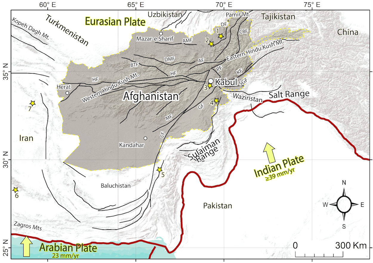
Afghanistan is one of the most seismically active intercontinental regions in the world. The country sits on the edge of the Eurasian tectonic plate. Natural hazards abound due to the nearby slow-motion collision of India into Asia. Northward motion of India at 1.5 inches per year (40 millimeters per year) dissects eastern Afghanistan and adjacent parts of Pakistan with a series of northeast-oriented left-lateral strike slip faults, in which rocks on either side of the fault move to the left relative to the other side. Compression between the tectonic plates results in shortening of the crust along thrust faults within the lobe-shaped Sulaiman and Salt ranges.
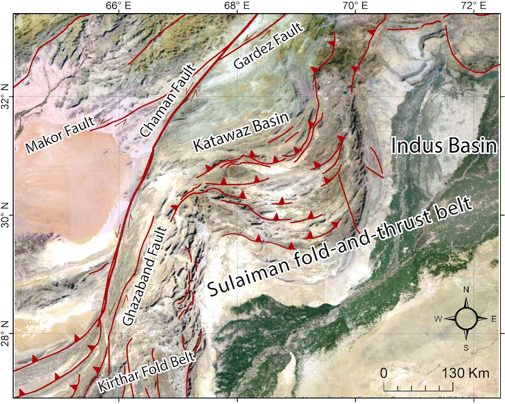
Active faulting is distributed even more widely across Afghanistan; northern parts of the country sit within the Afghan-Tajik depression — a large low-elevation depression surrounded by high glacial peaks, floored by sediments many kilometers thick, and cut through by numerous earthquake faults — and the Herat Fault stretches across the country, almost to the Iranian border. Within eastern Afghanistan, active faults raised the great mountain ranges of the Hindukush and Pamir, as well as wide belts of lower-elevation mountainous terrain, interwoven with low-relief sedimentary basins bounded by faults.
Rural populations are thinly spread across the mountainous regions. The basins, with abundant arable land and fed by waters from the surrounding high mountains, sustain higher densities of population, including large urban centers such as Kabul.
Faults dissect eastern Afghanistan
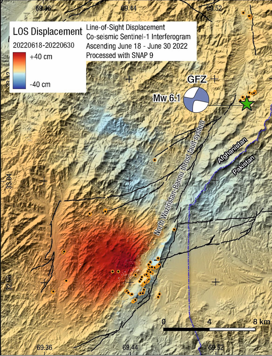
The magnitude, location and focal mechanism for the June 2022 earthquake have been computed from seismic networks around the world. Satellite radar interferometry — a remote sensing technique that compares images taken from a satellite over a period of time — has yielded detailed measurements of ground displacement during the earthquake. Considering these data, we determined that slip likely occurred on a roughly north-south oriented left-lateral strike-slip fault parallel to, and with an epicenter approximately 1.2 miles (2 kilometers) west of, and into the hanging wall of, the North-Waziristan-Bannu Thrust Fault system, in a region of exhumed and tightly folded sediments of Paleogene and Quaternary age.
The quake resulted from the northward collision of India into Eurasia. The most prominent structure within this zone is the Chaman Fault, which extends for much of the distance from the Makran coast of Pakistan to the Hindu Kush in northeastern Afghanistan. As the recent earthquake highlights, the fault, though prominent, is only one part of a broad zone of deformation, in which multiple widely distributed and often unmapped faults are present that can rupture in earthquakes large enough to cause significant damage and loss of life.
Surprising damage, but a common occurrence
The large death toll and widespread destruction caused by June’s moderate-sized magnitude-6.1 earthquake are surprising compared to others around the world; earthquakes of this magnitude and depth are generally far less destructive. But in this region, the devastating effects of earthquakes such as this are, sadly, all too common.
The June event is just one in a long line of damaging earthquakes that have hit Afghanistan. More than 15,000 people have been killed in such events in the last 24 years. Moderate to large earthquakes such as the Takhar earthquake (magnitude 6.5) in 1998 and the Nahrin earthquake (magnitude 6.1) in 2002 individually claimed the lives of thousands of people.
Similar situations exist across large parts of the interior of Asia, where the collisions of India and Arabia with Eurasia have activated belts of faults stretching from the Mediterranean to China, and where several factors combine to increase the vulnerability of populations. Earthquake disasters in Iran such as at Bam in 2003, Rudbar in 1990, Tabas in 1978 and Dasht-e-Bayaz in 1969, show the potential for devastation. The Tabas earthquake, for example, a magnitude-7.3 quake, killed 85 percent of the entire population in this rural region in the east of the country.
What makes the population so vulnerable?
Obviously, one of the factors that leads to increased vulnerability is the wide distribution of active faults in the region. Although a few of the major faults, such as the Chaman Fault in Afghanistan or the Main Kopeh Dagh Fault in Turkmenistan, slip at rates on the order of 1 centimeter per year (less than half an inch), other faults in the region slip more slowly. The recurrence intervals between earthquakes in any one area may be thousands of years. Because these shocks have not occurred in modern history, they are rarely in the minds and cultural memories of local populations and civic leaders. Without that memory, communities may not be prepared for a major disaster and individuals may not know how to protect themselves during shaking.

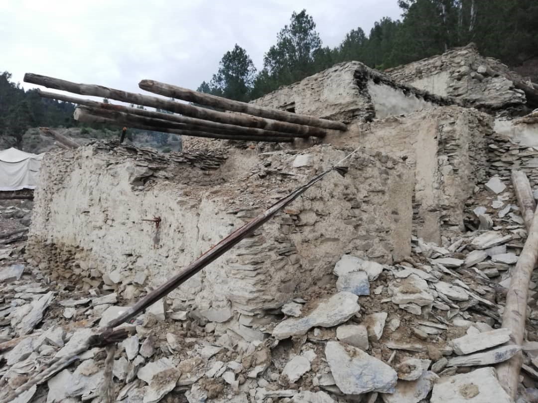
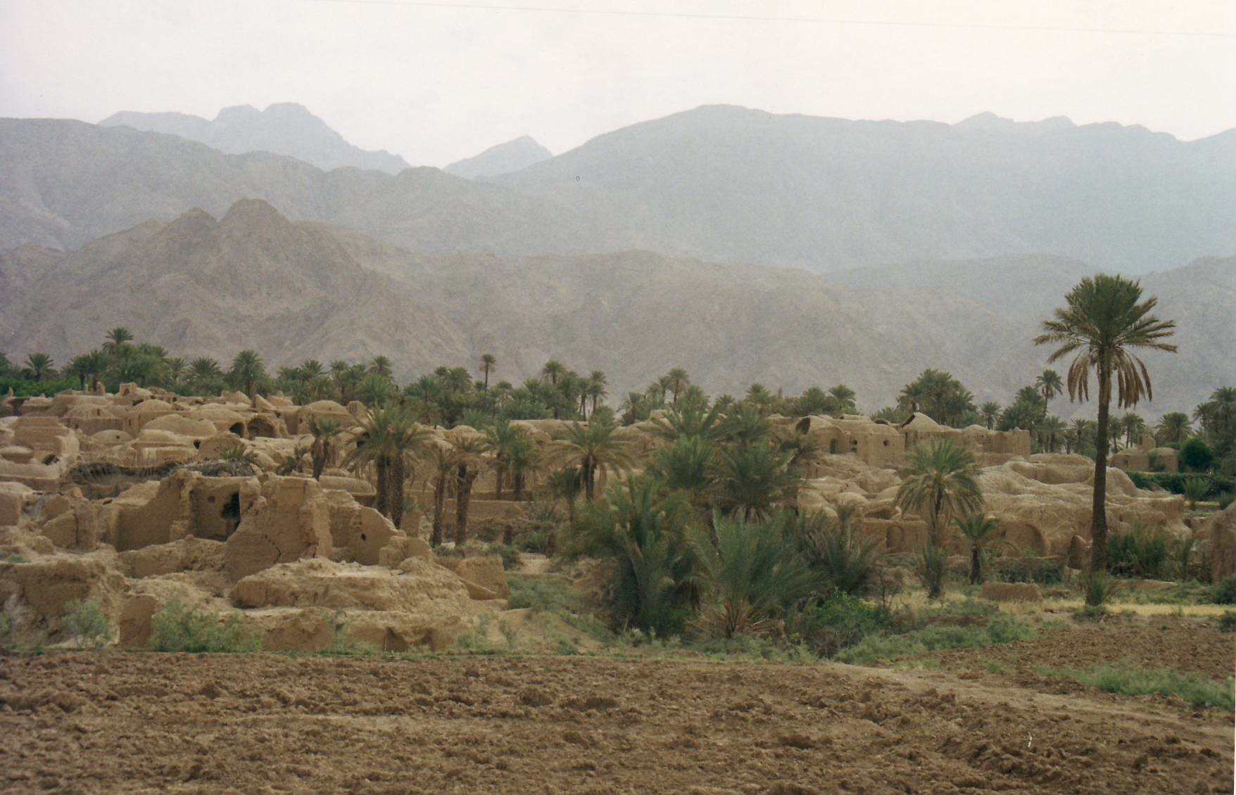
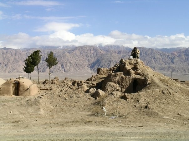
Construction styles are a second major factor in the vulnerability of rural populations. Unreinforced adobe construction with traditional building methods is the dominant style of rural construction across much of the Asian interior. Homes and other buildings consist of a thick flat or domed roof of dried mud supported by timber, siting on walls of mud brick or, in the case of the recently damaged villages in Afghanistan, of stone blocks cemented with dried mud.
These building styles are well suited to the climatic conditions. They insulate from extreme heat and cold and make use of cheap and locally sourced materials. They are, however, susceptible to collapse from shaking, with the collapse of their heavy walls and roofs leading to high fatality rates.
The environment also plays a large role in vulnerability. Populations across much of Asia are clustered in narrow fringes between desert and mountains, which provide opportunities for settlement and agriculture and offer pathways for migration and trade. But the mountain fringes are formed by active faults. Springs along the faults are often the main source of water, bringing life to otherwise inhospitable lands. Raised groundwater levels at the mountain edges can also be tapped through networks of Qanats — a type of underground canal. But the proximity to active faults, when combined with the traditional building styles, make nearby villages susceptible to even moderate, local earthquakes.
Reducing the risk
The continuing occurrence of destructive earthquakes in Afghanistan and surrounding regions provides an urgency in designing and implementing strategies to reduce vulnerabilities to earthquake hazards. Large cities and urban centers are expanding rapidly, with past settlements of traditional adobe replaced by high-rise blocks. Kabul, for instance, occupies a narrow north-south elongated basin that is bounded by faults. It is an ancient city, with recorded large earthquakes in 1505 and 1891, yet its population and urban infrastructure has grown from 500,000 to 3 million over past decades. Quetta — farther south along the Chaman Fault system in Pakistan — suffered a large magnitude-7.7 earthquake in 1935. Historical records also document damaging earthquakes elsewhere in Afghanistan, including Herat, Mazar-e-Sharif and Kandahar.
There is no quick and simple way to build resilience in regions such as those damaged in the June earthquake, and effective efforts toward the reduction of risk for future populations likely involve a wide range of disciplines working together. Geological, geophysical and historical analyses are all required to develop archives of past events, identify active faults and ensure that urban expansion and infrastructure development are based on the best available knowledge.
Engineering has an important role through the design of simple strategies for building with traditional materials and designs. But the success of any program ultimately rests on the ability to convince populations that there are ways of mitigating severe damage and loss by understanding hazards and by improving construction methods, which in turn only fully work if there are policy frameworks in place for their enforcement, with financial support in place.
Over the last few decades, Iranian scientists have worked to convince the government of the increased risk from earthquakes as cities grow. Collaboration between Iranian scientists and policymakers has now led to development of building codes that are revised every five years to improve building resilience. The latest update is expected to be released in 2023 and will incorporate updated knowledge of earthquake sources and active faults.
Within cities, it is the responsibility of builders to follow such codes. In rural areas, the situation is different, as building a resistant structure requires legislation as well as financial support. In rural parts of Iran, this support can come from long-term grants and loans from the government, which are conditional on builders following design standards and the guided plan of the village. Many villages with vulnerable adobe buildings still exist; however, these efforts will gradually improve the situation.
In Afghanistan, earthquake-resistant construction design guidelines were replaced with a formal building code in 2012. As in Iran, the building of resistant structures requires not only a code, but also effective enforcement and financial support. Much of the progress in Iran has occurred immediately after recent earthquake disasters, before governmental priorities shift to other concerns. We hope that if some good can come from the recent Afghanistan earthquake it is in effecting a long-term increase in resilience.
Acknowledgement
In writing this article we are particularly indebted to the work and ideas of Nicolas Ambraseys (1929-2012), Manuel Berberian, and James Jackson.
Further Reading
For those wishing to learn more about the earthquake hazards of the Asian interior, we recommend “A history of Persian Earthquakes” (Cambridge University Press) and “Earthquakes in Afghanistan” (Seismological Research Letters, 74, 2003) by Ambraseys and co-authors. We also recommend works by Berberian and Yeats, including “Tehran: an earthquake time bomb” (in GSA Special Paper 525), and the papers “Fatal attraction: living with earthquakes, the growth of villages into megacities, and earthquake vulnerability in the modern world” by James Jackson (10.1098/rsta.2006.1805) and “Uncharted seismic risk” by Philip England and James Jackson (10.1038/ngeo1168).