- Brief Report
- Open access
- Published:
The tale of three landslides in the Western Ghats, India: lessons to be learnt
Geoenvironmental Disasters volume 9, Article number: 16 (2022)
Abstract
In recent years, landslides have become a typical monsoon calamity in the Western Ghats region of Kerala, India. In addition to property damage, heavy rainfall (36% above normal) and multiple landslides (4728) killed 48 people in 2018. This tendency continued throughout the monsoon seasons of 2019, 2020, and 2021, resulting in the deaths of over 100 people. Anomalous precipitation is ascribed to the frequent development of low-pressure in the surrounding oceans. Using ground real data and satellite imagery, we evaluated the features of three large landslides in the state of Kerala, which occurred during the monsoon season of 2021. Our investigation found that the Kokkayar landslide was triggered by anthropogenic-related agricultural activities, the Plappally landslide by geomorphic and tectonic processes as well as human involvement, and the Kavali landslide by forest fragmentation with dense vegetation on thin soil. The triggering mechanism for all three of these landslides, however, is the intense rainfall of 266 mm in less than 24 h. Thus, an accurate and precise forecast of rainfall can be used to define a threshold for an early warning, which will be vital for saving lives.
Introduction
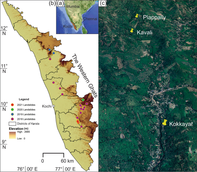
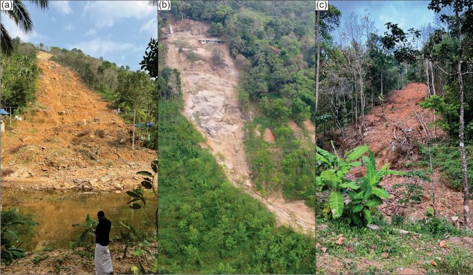
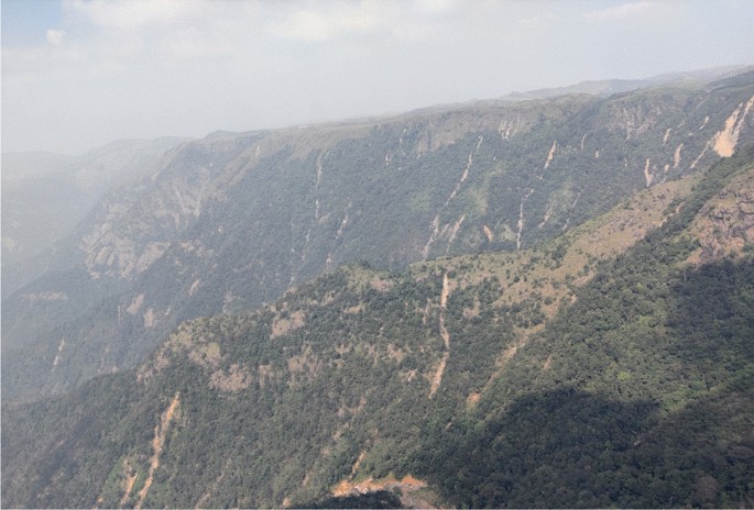
Catastrophic landslides have become a common monsoonal phenomenon in India’s southwest state of Kerala, which is located in the foothills of the prominent mountain chain, the Western Ghats. The anomalous rainfall of 2018, which was about 36% more than the normal rainfall (Vishnu et al. 2019), triggered 4728 landslides (Hao et al. 2020) and killed 48 people. These landslides occurred in a single storm-event i.e., 16th August 2018. The following years saw further landslides, with the monsoon season of 2019 witnessing disastrous landslides such as the one at Puthumala, which killed 17 people, and the Kavalappara, which killed another 59 people (Sajinkumar and Oommen 2020; Wadhawan et al. 2020). Both these landslides occurred on 8th August 2019. The Pettimudi landslide of 6th August 2020 was the most tragic one that killed 70 people and devastated several hutments in a tea plantation region (Achu et al. 2021; Sajinkumar and Oommen 2021). Year 2021 also experienced cataclysmic landslides on 16th October with the most disastrous ones being at Kokkayar in Idukki district and Plappally and Kavali, near Koottickal in Kottayam district. All these devastating landslides that occurred since 2018 showed an uneven geographic distribution (Fig. 1a, b), pointing to the possibility that many parts of the Western Ghats are susceptible to landslides, though these landslides are located along the same valley (Fig. 1c). In this study, we narrate the ground real data and interpretation of high-resolution remotely sensed images of the three landslides- Kokkayar, Plappally and Kavali (Fig. 2, a, b, c) that occurred in 2021. We also employed ethnographic techniques, such as in-depth interviews with elderly impacted individuals, to learn about their shared experiences. These three landslides are amongst the tens of landslides in the vicinity of the study area (Fig. 3). The reason for selecting these three landslides is because of their catastrophic nature resulting in many human casualties. We believe that the narrative of these three landslides applies to other landslides that occurred in the immediate vicinity of this area.
Site and situation of the landslides
Kokkayar landslide
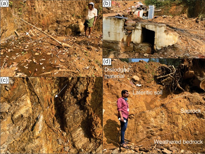
Kokkayar landslide (9°34′21''N; 76°53′13''E) of Peermade taluk in the Idukki district of Kerala has killed seven people and completely destroyed seven houses. The dimension of this landslide is 500 m (length) × 40 m (avg. width) × 1 m (avg. thickness). Rubber plantations predominantly occupy the area with intermittent clusters of mixed vegetation. The area is utilized for agriculture through terrace cultivation with the cut slope protected by rubble masonry wall. Rain pits were constructed on this slope. Houses are constructed by the cut and fill method but without any support in the cut slope. Most of the houses have dug wells and the depth to water level is shallow (< 2 m) whereas during the landslide these were found overflowing (as per local witness), pointing to the fully saturated column of soil. Numerous springs spout from this area (Fig. 4a). This spouting phenomenon existed before landslides because dwellings have drains to flush away storm water (Fig. 4b). These observations indicate that a seasonal first and/or second-order stream flows through this area, which might have been modified during the course of agriculture and/or habitation. A few fresh gullies have been formed, to which water is now confined.
The in-depth interviews with the local people revealed that the vegetation, mainly rubber trees were clear-felled after slaughter tapping a few years prior to the event. Contour bunding and rain-pits were made prior to replanting the rubber saplings. These interventions seem to have taken place ignoring the natural hydrological requirement of letting the first/second order streams to have its free flow channels. Such interventions may have contributed to destabilizing of soil on the slopes.
The area is characterized by outcrops of hornblende biotite gneiss. The general trend of this foliated rock is 173°/35 W. The preponderance of feldspar in this rock and its subsequent alteration through weathering has resulted in the formation of clay. The rock is highly jointed, and weathering is found to be extensive along these joints (Fig. 4c). The crown of the landslide is occupied by bouldery outcrops of this rock with no soil cover. Hence, during monsoon, all the water in the crown part has surcharged the immediately downslope column of lateritic soil causing an increase in pore-water pressure. Near the flanks of the landslide, the soil profile shows dislodged soil followed by lateritic soil of 1 m thickness and another 1 m thick saprolite (Fig. 4d). This is further followed by bedrock. The dislodged material was finally dumped into the Pullakayar, a tributary of Manimala River.
Plappally landslide
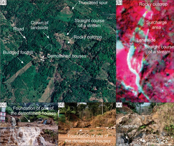
Plappally landslide (9°37′3''N; 76°52′21''E) in Kanjirapally taluk of Kottayam district has killed four people and demolished two buildings. This landslide of 500 m (length) × 20 (avg. width) × 1 m (avg. thickness) was initiated in a rubber plantation whereas its runout stretches through areas of different land use types. In the Google Earth image (before landslide), the upslope in which the landslide occurred is confined is a truncated spur and its right boundary is marked by a straight lower-order river course, indicating a lineament (Fig. 5a). Due to the broader surface area of this spur, the run-off zone is more extensive. The storm water when crossing the barren rock outcrop, situated downslope, facilitates sudden surcharge to the thin veneer of soil lying immediately downslope. It is in this zone the recent landslide was initiated. The surcharge zone can be well seen in the high-resolution (3 m) False Colour Composite (FCC) of Planet Lab (Fig. 5b). The truncated spur together with the bulged foothill suggests this as a paleo-landslide, within which the recent landslide occurred.
a Google Earth image showing a distant view of Plappally landslide showing a suspected lineament, remnants of paleolandslide and its associated truncated spur (b) 3 m resolution FCC of Planet Lab image showing the landslide runout and its surcharge area (c) Storm water gushing through the uprooted house location (d) The ruins of the devastated house, which was constructed along the course of a lower-order stream (e) Seepage along the joints of hornblende biotite gneiss
This landslide is also confined to a lower-order stream course. The two buildings, which were destroyed, were constructed precisely on the river course. Water gushes through this during the monsoon (Fig. 5c), whereas it is dry during the non-monsoon season (Fig. 5d) showing its seasonal nature. But seepage can be seen along the joints of the country rock, hornblende biotite gneiss (Fig. 5e). Here again, in the upper slope, where the houses stood before the landslide, plantation with young rubber trees existed, which indicates a similar influencing factor like at Kokkayar.
Kavali landslide
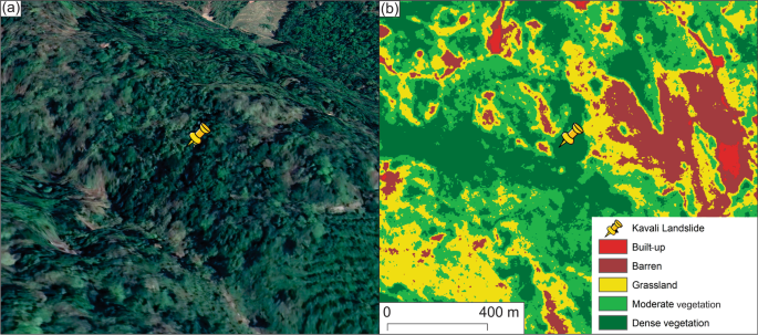
Six people died and one house was demolished by the Kavali landslide, which is 250 m (length) × 15 (avg. width) × 2 m (avg. thickness) in dimension. Hornblende biotite gneiss is the country rock, which is highly weathered and jointed. The attitude of this highly foliated rock is 315°/80NE. Here too, spring water is tapped for domestic purposes. The destroyed house was constructed in a cut-slope, but the cut-slope is still retained after the landslide. The cut-slope profile exhibits lateritic soil, saprolite, and weathered bedrock. The area is characterized by thick vegetation when compared to the sparse vegetation in the adjacent area. This thick mixed vegetation with rubber plantation is the major crop, followed by nutmeg, arecanut, and teak. Google Earth image (Fig. 6a) also revealed thick vegetation. A Normalized Difference Vegetation Index (NDVI) map was created using the high-resolution Planet Lab image to understand the area’s land use. NDVI revealed that the landslide occurred in a densely vegetated area when compared to other areas consisting of a wide variety of land uses like moderate vegetation, grassland, barren outcrop, and built-up. Usually, landslides are less reported in densely vegetated areas (cf. Alcantara-Ayala et al. 2006; Reichenbach et al. 2014). In contrast to this, a recent study by Lan et al. (2020) suggests that a densely vegetated slope decreases its stability. This study has been concurred with by the recent findings of Hao et al. (2022) wherein most of the landslides that occurred in Kerala during 2018 are spatially associated with forest land. However, a closer look at Fig. 6a, b reveals forest fragmentation and breaking-off of the contiguity of the forest canopy, creating scattered and fragmented forest islands. Studies reveal that such a process could compromise landscape integrity (Ramachandra and Kumar 2011; Batar et al. 2021).
Discussion
The Western Ghats, especially its southern part encompassing the entire state of Kerala, witness landslides often during monsoon season. Since 2018, the noteworthy feature of the monsoon has been that it triggers landslides during the sporadic high-intensity rainfall (cf. Vishnu et al. 2019, 2020; Yunus et al. 2021; Sajinkumar et al. 2022). Though several studies have been conducted in this region, and measures suggested were not adopted, we present here specific omnipresent reasons that facilitate landslides in this region.
Introspection of land use policy
The recent landslide susceptibility map of Kerala (cf. Sajinkumar and Oommen 2021; Escobar-Wolf et al. 2021) shows an area of 3300 and 2886 km2 as highly and moderately susceptible to landslides, respectively. It will be an arduous task to implement stringent measures such as habitation- and construction-free zones in these areas. However, some of the landslide-facilitating practices that are common, may be inadvertently so, can be averted. Kerala is predominantly an agrarian state, and the general agricultural land use seen are cash crops, with rubber plantations occupying the midlands and tea, coffee and cardamom in the highlands. All the three landslides occurred in the midlands, especially where rubber plantation dominates the land use. The construction of rain pits is a common practice in almost all rubber estates. Major disturbance to the slope stability occurs when fully matured rubber trees are slaughtered after their life span of ~ 20 years, and fresh saplings are planted in a broad pit of 1 m3 size. Rain pits are also dug here. The method of stubble mulching is not practiced here and large area of land will be disturbed when the trees are uprooted using machinery. Hence, avoiding rain pits, planting pits, and promoting stubble mulching practice will help reduce the probability of landslide occurrences. Avoiding rain pits and planting pits in susceptible landslide areas will help increase run-off rather than infiltration. In addition, all agricultural techniques on the hilly slope affects the lower-order drainage, by obstructing it with rubble-masonry walls, redirecting it to a more hazardous slope, or by constructing houses. These lower-order courses, except in thickly vegetated forest areas, are usually seasonal, and during monsoon season, the normal flow of water is thus disturbed by these practices. Hence, a stringent land use policy to avoid such practices in agricultural fields is a pressing requirement.
Rainfall- the sole triggering factor
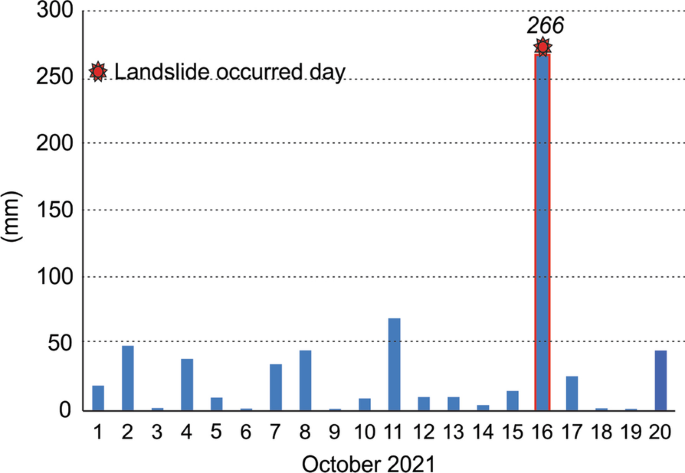
As mentioned, these three landslides were also triggered by a sporadic-high intensity rainfall of > 266 mm in a single day (Fig. 7) but with a 5-day antecedent rainfall of only 109.9 mm. The comparatively higher rainfall of 48.8 (2nd October), 45.4 (8th October and 69.6 mm (11th October) might have saturated the soil column and the 16th October anomalous event was sufficient enough to trigger landslides. In order to limit the risk of rainfall-induced landslides, an accurate and exact rainfall forecast that allows for the issuance of early warnings based on the rainfall threshold of the area is essential (Weidner et al. 2018). The sparse density of rain gauges and manual operation methods make things difficult. For e.g., the rain gauge station nearest to these three landslides is Kanjirapally, approximately 10 km away from this landslide, which is grossly inadequate to capture the micro-climatic conditions of the susceptible areas. Moreover, this rain gauge station is a manual one with daily rainfall recording on the succeeding day at 8.30 am (www.imd.gov.in). Having automated rain gauges that report rain information near real-time will be critical for developing early warning systems.
Soil thickness and soil-rock interface plane
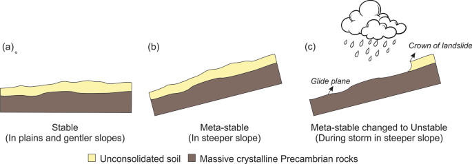
The hilly area of the entire state of Kerala is characterized by a thin veneer of unconsolidated soil, resting above the massive Precambrian crystalline rock except for plateau regions like Munnar and Nelliyampathy (Sajinkumar and Anbazhagan 2015). Usually, the glide plane of the landslides will be the contact plane of these two litho-units (cf. Istiyanti et al. 2021). Thus, wherever the landslide occurs, the bedrock will be exposed, which can be seen in all these three landslides. Hence, along with the understanding of landslide susceptibility, the soil thickness of the area and the saturation capacity of that soil column have to be investigated. The contact between these two litho-units is stable in a plain or gentler slope (Fig. 8a) whereas it will be in a meta-stable position when in a steep slope (cf. Getachew and Meten 2021; Puente-Sotomayor et al. 2021) (Fig. 8b). This equilibrium will be lost when the soil column is saturated by water during the monsoon season (Fig. 8c).
Conclusion
The three landslides that occurred on 16th October 2021 are located in the same valley, and were triggered by a high-intensity rainfall of 266 mm in one day. These similarities are never the same when conditioning factors are analyzed. The steep slopes of the hilly regions where all three landslides occurred originally contained natural contiguous forests that may have held the thin soil and regolith layer together. The modern landscape, however, is dominated by human interventions such as the replacement of natural vegetation with plantations, highways, and human settlements. These measures facilitated the triggering of the landslides by a sudden storm of intense rainfall (cf. Lahai et al. 2021). However, a closer check using ground reality and satellite photographs revealed that the Kokkayar landslide was completely caused by humans, whereas the Plappally landslide was also affected by geomorphic and tectonic causes. The third site, the Kavali landslide, was caused by forest fragmentation on the forest island. Consequently, regardless of the contributing components, the common and vital feature to be researched is the rainfall dynamics, which can be converted into early warning systems, thereby saving countless lives.
References
Achu AL, Joseph S, Aju CD, Mathai J (2021) Preliminary analysis of a catastrophic landslide event at Pettimudi, Kerala state. India Landslides 18:1459–1463
Alcántara-Ayala I, Esteban-Chávez O, Parrot JF (2006) Landsliding related to land-cover change: a diachronic analysis of hillslope instability distribution in the Sierra Norte, Puebla, Mexico. CATENA 65:152–165
Batar AK, Shibata H, Watanabe T (2021) A novel approach for forest fragmentation susceptibility mapping and assessment: a case study from the Indian Himalayan region. Remote Sens 13(20):4090
Escobar-Wolf RV, Sanders JD, Oommen T, Sajinkumar KS, Vishnu CL (2021) A GIS tool for infinite slope stability analysis (GIS-TISSA). Geosci Front 12(2):756–768
Getachew N, Meten M (2021) Weights of evidence modeling for landslide susceptibility mapping of Kabi-Gebro locality, Gundomeskel area central Ethiopia. Geoenviron Disasters 8(1):1–22
Hao L, Rajaneesh A, van Westen C, Sajinkumar KS, Martha TR, Jaiswal P, McAdoo BG (2020) Constructing a complete landslide inventory dataset for the 2018 Monsoon disaster in Kerala, India, for land use change analysis. Earth Syst Sci Data 12(4):2899–2918
Hao L, van Westen C, Rajaneesh A, Sajinkumar KS, Martha TR, Jaiswal P (2022) Evaluating the relation between land use changes and the 2018 landslide disaster in Kerala, India, for land use change analysis. CATENA 216:106363
Istiyanti ML, Goto S, Ochiai H (2021) Characteristics of tuff breccia-andesite in diverse mechanisms of landslides in Oita Prefecture, Kyushu Japan. Geoenviron Disasters 8(1):1–14
Lahai YA, Anderson KF, Jalloh Y, Rogers I, Kamara M (2021) A comparative geological, tectonic and geomorphological assessment of the Charlotte, Regent and Madina landslides, Western area Sierra Leone. Geoenviron Disasters 8(1):1–17
Lan H, Wang D, He S, Fang Y, Chen W, Zhao P, Qi Y (2020) Experimental study on the effects of tree planting on slope stability. Landslides 17:1021–1035
Puente-Sotomayor F, Mustafa A, Teller J (2021) Landslide susceptibility mapping of urban areas: logistic regression and sensitivity analysis applied to quito Ecuador. Geoenviron Disasters 8(1):1–26
Ramachandra T, Kumar U (2011) Characterisation of landscape with forest fragmentation dynamics. J Geogr Inf Syst 3(3):242–253
Reichenbach P, Busca C, Mondini AC, Rossi M (2014) The influence of land use change on landslide susceptibility zonation: the Briga catchment test site (Messina, Italy). Environ Manage 54:1372–1384
Sajinkumar KS, Anbazhagan S (2015) Geomorphic appraisal of landslides on the windward slope of Western Ghats, southern India. Nat Hazards 75(1):953–973
Sajinkumar KS, Oommen T (2020) Rajamala landslide: continuation of a never-ending landslides series. J Geol Soc India 6:310
Sajinkumar KS, Arya A, Rajaneesh A, Oommen T, Ali P, Yunus RVR, Avatar R, Thrivikramji KP (2022) Migrating rivers, consequent paleochannels: the unlikely partners and hotspots of flooding. Sci Total Environ 807:150842
Sajinkumar KS, Oommen T (2021) Landslide atlas of Kerala. Geol Soc India, p 34.
Vishnu CL, Sajinkumar KS, Oommen T, Coffman RA, Thrivikramji K, Rani VR, Keerthy S (2019) Satellite-based assessment of the August 2018 flood in parts of Kerala, India. Geomat Nat Hazards Risk 10(1):758–767
Vishnu CL, Rani VR, Sajinkumar KS, Oommen T, Bonali FL, Pareeth S, Thrivikramji K, McAdoo BG, Anilkumar Y (2020) Catastrophic flood of August 2018, Kerala, India: partitioning role of geologic factors in modulating flood level using remote sensing data. Remote Sens Appl Soc Environ 2:100426
Wadhawan SK, Singh B, Ramesh MV (2020) Causative factors of landslides 2019: case study in Malappuram and Wayanad districts of Kerala. India Landslides 17:2689–2697
Weidner L, Oommen T, Escobar-Wolf RV, Sajinkumar KS, Rinu S (2018) Regional scale back-analysis using TRIGRS: An approach to advance landslide hazard modeling and prediction in sparse data regions. Landslides 15(12):2343–2356
Yunus AP, Fan X, Subramanian SS, Jie D, Xu Q (2021) Unraveling the drivers of intensified landslide regimes in Western Ghats, India. Sci Total Environ 770:145357
Acknowledgements
The authors thank Kerala State Disaster Management Authority (KSDMA) for facilitating fieldwork in these areas. Jobin Sebastian, a freelance photographer and paraglide trainer, is highly thanked for providing photos (Figs. 1d and 2). The lab work was carried out at the Laboratory for Earth Resources Information System (LERIS) housed at the Department of Geology, University of Kerala. LERIS is a collaborative initiative of Indian Space Research Organization and University of Kerala.
Funding
The author declare that there is no funding in the manuscript.
Author information
Authors and Affiliations
Contributions
RSA-Field visit, manuscript writing DN-Field visit, manuscript writing AR-Data analysis, figure preparation TO-Data analysis, figure preparation, manuscript writing YPA-Data analysis, figure preparation, manuscript writing KSS-Field visit, Data analysis, figure preparation, manuscript writing, supervision
Corresponding author
Ethics declarations
Ethical approval
The data employed in this work is accessible to the public upon request and therefore ethical approval is not required. This paper is not being submitted to any other journal at the same time.
Competing interests
The authors declare that we have no financial and personal relationships with other people or organizations that can inappropriately influence our work, there is no professional or other personal interest of any nature or kind in any product, service, and/or company that could be construed as influencing the position presented in, or the review.
Additional information
Publisher's Note
Springer Nature remains neutral with regard to jurisdictional claims in published maps and institutional affiliations.
Rights and permissions
Open Access This article is licensed under a Creative Commons Attribution 4.0 International License, which permits use, sharing, adaptation, distribution and reproduction in any medium or format, as long as you give appropriate credit to the original author(s) and the source, provide a link to the Creative Commons licence, and indicate if changes were made. The images or other third party material in this article are included in the article's Creative Commons licence, unless indicated otherwise in a credit line to the material. If material is not included in the article's Creative Commons licence and your intended use is not permitted by statutory regulation or exceeds the permitted use, you will need to obtain permission directly from the copyright holder. To view a copy of this licence, visit http://creativecommons.org/licenses/by/4.0/.
About this article
Cite this article
Ajin, R.S., Nandakumar, D., Rajaneesh, A. et al. The tale of three landslides in the Western Ghats, India: lessons to be learnt. Geoenviron Disasters 9, 16 (2022). https://doi.org/10.1186/s40677-022-00218-1
Received:
Accepted:
Published:
DOI: https://doi.org/10.1186/s40677-022-00218-1
