

Abstract
Despite efforts to understand the hydrologic impact of hydropower dams, their influence on downstream river temperatures has gone unnoticed in data limited regions. Using 30 years of Landsat thermal infrared observations (1988–2018), we identified a relationship between dry season water temperature cooling trends and dam development in the 3S Basin, a major tributary of the Mekong River. Within a year of the beginning of operations of major dams in the 3S River Basin, rapid decreases in annual average dry season river temperature were observed ranging between 0.7 ° C and 2 ° C. Furthermore, in situ water temperature observations confirmed decreasing river temperature for two major dam development events. Evidence was found that the 3S outflow has been cooling the Mekong River downstream of the confluence, by as much as 0.8 ° C in recent years. Our findings are critically important for understanding how fish and aquatic ecosystems will behave in the future as more hydropower dams are built in the Mekong River Basin.
Export citation and abstract BibTeX RIS
1. Introduction
The Mekong River Basin (MRB) in Southeast Asia (figure 1, right panels) is currently going through a hydrologic transformation (Molle et al 2012). Growing demand for renewable energy and the economic benefits it brings has driven dramatic hydropower development in the MRB over the last 20 years and continues into the coming decades (WLE 2017). As Laos vies to be the 'battery of Asia', with plans to build an unprecedented nine dams on the currently free flowing main stem of the Mekong River, the region is poised to drastically increase its ability to produce renewable energy. However, with the economic benefits of hydropower comes environmental costs y -25(Winemiller et al 2016). Dams in the MRB have already significantly altered sediment transport (Lu and Siew 2006, Kummu and Varis 2007, Fu et al 2008), river connectivity (Grill et al 2014), and streamflow (Lu et al 2014, Bonnema and Hossain 2017). These and other alterations to the natural river system threaten downstream fish and rice production, and by extension, the food security of millions of inhabitants of the region (Lauri et al 2012, Ziv et al 2012, Kondolf et al 2014). In spite of the extensive effort towards understanding the changing river system in the face of dam development, there is one critical impact of dams that has gone undetected, the aggregate effects of dams on downstream water temperature.

Figure 1. Map of 3S Basin showing existing and future (under construction, planned, and proposed) dams as of 2017 (WLE 2017) as well as the locations of three water quality monitoring stations. Major dams were defined as dams located on a major river or a tributary with a significant impounded reservoir (>25 km2 surface area). Minor dams consisted of dams on smaller tributaries, and run-of-the-river style dams on major rivers with no impounded reservoir and unlikely thermal stratification. Further details on estimation of kinetic temperature from Landsat data are provided as a supplement.
Download figure:
Standard image High-resolution imageHydropower dams tend to cool the downstream water temperature by releasing water from the penstock located at deeper levels of thermally stratified reservoirs (Sherman et al 2007, Niemeyer et al 2018). Changes in the thermal regime of rivers in the MRB may threaten fish production downstream, a source of food and livelihood for millions (Ahmed et al 1998, Mekong River Commission 2003). The Mekong River and its tributaries are home to one of the largest inland fisheries in the world (Baran and Myschowoda 2009). Sustained and extensive perturbations in the thermal regime of the river, would have significant impacts on the health of the fish population (Ficke et al 2007) and regional biodiversity (Liermann et al 2012). The MRB severely lacks in situ temperature monitoring stations, causing dam driven temperature change to remain hidden and unexplored. Satellite remote sensing estimates can mitigate this lack of in situ observations and help illuminate the potential thermal impacts of dams. The Landsat Mission thermal infrared (TIR) sensors are a promising option due to high revisit time (16 days), high spatial resolution (60–120m), and a long historical record. Landsat TIR data has been used before to monitor river temperatures (Dugdale 2016, Ling et al 2017, Tavares et al 2019), but not in the context of the dam development in the MRB, to the best of our knowledge. Applying TIR data to the MRB allows for the monitoring of river temperature in locations that were previously un-monitored. This is key to understanding the thermal impacts of current dams and predicting the impacts of dams that are not yet built.
The 3S Basin (figure 1), the largest tributary to the Mekong River (Adamson et al 2009), is a prime location to reveal the hidden thermal impacts of dams. The 3S Basin is a microcosm of dam development in the MRB, with many small, upper tributary dams already built and progressively larger dams planned or under construction on the main rivers. In other words, 3S Basin is like a time capsule - what is now happening now to the lower Mekong River in general has already been happening to the 3S Basin since the 2000s. In addition, the two basins have strikingly similar hydro-climatic properties. The 3S Basin also suffers from a lack of in situ river temperature observations, with only three monitoring stations (figure 1) operational for more than 5 years. The basin consists of three major rivers (Sekong, Sesan, and Srepok), draining from southern Lao PDR, western Vietnam, and eastern Cambodia before emptying into the Mekong River. While the three sub-basins are undergoing hydropower development, they are being developed at different rates (WLE 2017). Major dams on the Sesan River were constructed in 2001, 2008, and 2009, while major dams on the Sekong River were not installed until 2015 (WLE 2017). Direct comparisons of stream temperature trends between three basins at different stages of development allow for the identification of dam driven temperature changes. Understanding how river temperature is changing in the 3S Basin and the source of those changes is critical for better managing rice and fish production downstream (Arias et al 2014, Kummu and Sarkkula 2008). This is especially true in the coming decades, with more major dams planned for all three rivers.
This study presents the results of the application of Landsat 4, 5, 7, and 8 TIR observations towards monitoring changes in river temperature in the 3S Basin in an attempt to answer: Are dams in the 3S Basin causing changes in stream temperature and if so, what are the impacts on the temperature of the Mekong River?
2. Materials and methods
Landsat thermal infrared (TIR) data has seen wide use in estimating land and lake surface temperature, but its application to rivers has only recently gained traction (Dugdale 2016). Despite this, recent studies have estimated river temperatures with uncertainties as low as ±0.4 ° C (Wawrzyniak et al 2012). In this study, dry season water surface temperature estimates derived from Landsat TIR data from 1988 to 2018 are compared with the timing of upstream hydropower dam developments to explore the role that hydropower plays in altering stream temperature. TIR data for water surface temperature estimation of the Sekong, Sesan, and Srepok rivers are derived from Landsat 4, 5, 7, and 8. A flowchart of the temperature estimation process is shown in figure S.1 (see the supplementary data, available online at stacks.iop.org/ERL/15/044017/mmedia). Only the late dry season (January through April) is considered here because this is the only time period in which consistent cloud free images are available. In this process, Landsat visible/near infrared imagery is classified to identify the extent of the river surface, TIR data is cropped to the river extent, and the surface temperature is estimated using a single channel algorithm described in Jiménez-Muñoz et al (2008). This algorithm uses atmospheric vapor content, here taken from the NCEP/NCAR reanalysis dataset, to correct for atmospheric effects on the TIR band. The reaches of each of the three major 3S Rivers observed in this study are highlighted in green in figure 1 and their length, average width, and distance downstream from nearest dam are shown in table 1. These reaches are selected to minimize the distance to the nearest dam, while ensuring that the rivers remain wide enough during the dry season to be distinguishable from the land in the TIR band. Google Earth Engine, which has been successfully applied to large Landsat image processing tasks in the past (Pekel et al 2016), is leveraged here to estimate surface temperature from 1364 Landsat images.
Table 1. Characteristics of the river reaches observed using Landsat TIR data.
| River | Reach length (km) | Distance downstream from nearest dam (km) |
|---|---|---|
| Sekong | 104 | 73 |
| Sesan | 107 | 56 |
| Srepok | 134 | 78 |
Download table as: ASCIITypeset image
Monthly stream temperature observations from the three monitoring stations in the 3S Basin (figure 1) from 2004 to 2011 are used to validate the Landsat based water surface temperature estimates (figure S.2). This monthly in situ dataset, while limited by its short 7 year record, is also used to examine changes in the seasonality of the river temperature over time. To complement this investigation into water temperature seasonality, the seasonal operating patterns of upstream reservoirs are derived using visible/near infrared imagery, synthetic aperture radar (SAR) data, and topographical information (see supplement for methodology). Other factors that could impact the change in water temperature are also investigated, including air temperature, precipitation, and deforestation using global climatologic datasets and land cover classification datasets described in the supplement.
3. Results
3.1. River temperature: the view from space
By leveraging thermal infrared data from 1364 satellite images from Landsat 4, 5, 7, and 8, we constructed annual timeseries of average late dry season (January–April) water surface temperature of the three major 3S rivers, aggregated from the entire river reach downstream of all current dams (figure 1, left panel—reach highlighted in green), from 1988 through 2018 (figure 2). From these timeseries, a remarkable relationship emerges between the construction and operation of major dams (dams on major rivers with >25 km2 surface area) and downstream river temperature. Major dams were defined as dams that form significant reservoirs on the main stem or on a major tributary of one of the three major 3S Rivers. On all three rivers, significant temperature decreases were observed within one year of the beginning of operations of a major dam. These temperature changes were most clearly observed on the Sesan River, which experienced the construction of three major dams. In 2001, the Sesan River dry season water temperature experienced a 1 °C decrease, corresponding with the commissioning of the Yali Dam, first major dam on the river (figure 2, middle panel). The water temperature dropped again between 2008 and 2009, by around 2 °C and again, this temperature change corresponds with the timing of two major dams, Sesan 4, and Plie Krong, starting operations (figure 2, middle panel). The Srepok River also experienced dam development in 2009, with a network of 4 dams coming online in 2009. Once again, a sharp decrease in temperature was observed. Between 2007 and 2009, the water temperature dropped by 1.4 °C (figure 2, lower panel). The Sekong River experienced a temperature decrease corresponding with the commissioning of the Xe Kaman Dam in 2015, but with less severity than the other two rivers, only dropping by 0.7 °C over the course of three years (figure 4, upper panel). This can be attributed to the fact that the Xe Kaman Dam impounds a major tributary of the Sekong River, and not Sekong River itself, meaning that it only influenced the temperature of a portion of the water observed by the satellite data. Unfortunately, the tributary is not wide enough in the dry season to be accurately resolved by the thermal Landsat data, so the thermal impacts of this dam can only be deduced downstream after the impacted water has mixed with relatively free flowing water. The 0.7 °C–1.4 °C temperature decreases observed on all rivers appear larger compared to the observed uncertainty in the annual averages which ranges from 0.1 °C to 0.3 °C.
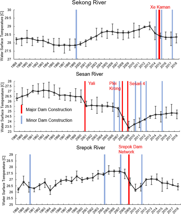
Figure 2. Timeline of dam development in each sub-basin and corresponding average annual Landsat based dry season river temperature downstream of dam development. Error bars represent 50th percentile bounds.
Download figure:
Standard image High-resolution imageAnother characteristic of the Landsat temperature time series is that the river surface temperature appears unaffected by the influence of minor dams. Here, dams were classified as minor for one of two reasons. Several of the dams on the main stems of the major rivers are run-of-the-river style impoundments and do not create a sizeable reservoir. This means the water behind the dam does not thermally stratify, resulting in little thermal change to the downstream river. Most of the minor dams however, are located on smaller tributaries and impound only a fraction of the total basin discharge.
A third feature of the satellite-based temperature timeseries is that all three rivers experience temperature changes unrelated from dam development. Each river goes through periods of warming. For the Sekong, and Srepok Rivers, these warming periods last greater than 10 years and overall equal or exceed the temperature decreases apparently caused by reservoirs, resulting in river temperatures ending around the same as they were in 1988, at the beginning of the time series. The Sesan River however goes through shorter periods of warming, which are not enough to offset the temperature drops. Clearly, there are other factors influencing river temperature and some possible sources of warming are explored in following sections. The possible influences of air temperature, precipitation, and forested area changes on river temperature are therefore explored further in section 3.3.
3.2. River temperature: limited ground observations
The in situ water temperature monitoring stations provided monthly temperature observations but were only in operation from 2004 through 2011. While this time period misses the commissioning of the Xe Kaman Dam in the Sekong River Basin (which occurred in 2015), it captures clearly the construction of major dams on both the Sesan and Srepok Rivers in 2008 and 2009. Since the monitoring stations were in operation year-round, the observations also provided valuable insight into the seasonality of perceived thermal influence exerted by hydropower dams on the downstream reaches. To that end, we separated the datasets into pre- and post-dam time periods. The Sekong in situ temperature was also split at 2008 to serve as a reference. From these datasets, we constructed a monthly average water temperature profile for each river during pre- and post-dam construction periods (figure 3).
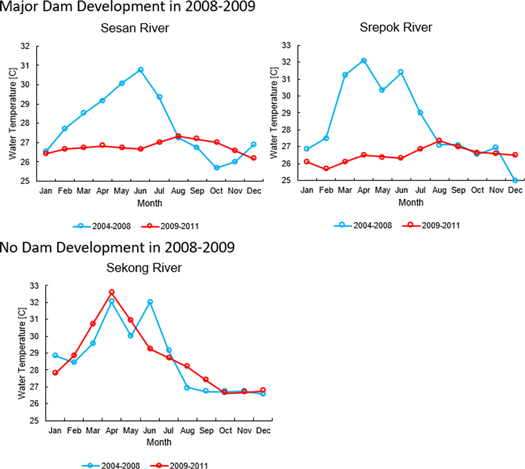
Figure 3. Average monthly river temperature from in situ monitoring stations, separated into pre- and post-dam construction periods. The Sekong River experienced no major development within this time period and the separated time periods are shown as a reference.
Download figure:
Standard image High-resolution imageThe pre- and post-dam differences in monthly water temperature for Srepok and Sesan Rivers are striking, with both experiencing drastic cooling in the late dry season after dam construction. More importantly, these cooling effects linger into the first half of the wet season (May, June, and July), when streamflow significantly increases. This is critical because it represents a stabilization of seasonal water temperature. In other words, dams are eliminating the naturally occurring seasonal water temperature variance. These stark post-dam temperature changes are contrasted by an absence of change in water temperature seasonality in the free flowing Sekong River over the same time period. Sesan River temperature post-dam construction was cooler throughout the late dry season (February through May and into the beginning of the wet season (June and July)), with the difference growing to approximately 4 °C in June (figure 3, upper left panel). However, from August through January, there was little change after dam construction. The Srepok River experienced a similar pattern, but peak temperature difference of 6 °C occurred earlier in the season in April (figure 3, upper right panel). One possible explanation for the slight difference in seasonality between the Sesan and Srepok is that the Sesan already had one major dam present during the pre-dam period while the Srepok was relatively free flowing until 2009. This means there was likely a thermal influence on the Sesan River temperature during the pre-dam time period.
To help explain the seasonality of the temperature effects, we need to look at patterns in the way reservoirs store and release water, otherwise known as operating patterns. Most reservoir operations follow patterns based on seasonally dependent hydrologic conditions (i.e. upstream precipitation and runoff) and objectives (i.e. hydropower production, flood control, water supply, etc). Since the governing rules that the dam operators in the 3S Basin follow are unknown to us and in situ reservoir observations of storage or outflow are limited, we used remote sensing observations to derive average monthly storage patterns using a proven approach we developed in a previous study (figure 4; Bonnema and Hossain 2017). This was done using Sentinel-1 satellite mission's SAR data to estimate changes in reservoir surface area, and linking these surface area changes to storage estimates using topographical information from the Shuttle Radar and Topography Mission. Details on how reservoir operating pattern was estimated are provided in the supplement. On the Sesan River, the three major rivers all follow the same general pattern, starting relatively full in January and draining throughout the dry season to minimum storage, then filling back up in the early to mid-wet season, with filling beginning between May and July. During the low inflow dry season months, the reservoirs have the most control over downstream streamflow. Only one reservoir on the Srepok River follows this pattern, with the remaining dams operating at a relatively static level throughout the year. However, this dynamic reservoir is considerably larger than the other Srepok River reservoirs. When inflow increases in the wet season, two things happen. First, to ensure adequate storage for flood control, reservoir outflow increases dramatically to keep water levels in the reservoir sufficiently low. Second, the temperature of the water flowing into the reservoir likely decreases due simply to the abundance of fresh runoff. This is consistent with the cooling observed at the in situ temperature monitoring stations in the beginning of the wet season (May through July) because during this time, the reservoirs are more rapidly discharging water from the cooler layers, while upstream inflow remains warmer. As the wet season continues into August, the natural streamflow becomes colder, to the point where the reservoir stratification no longer exerts a cooling effect on the river downstream. In other words, the river naturally cools down to the temperature of the stratified reservoir outflow and no temperature change occurs.
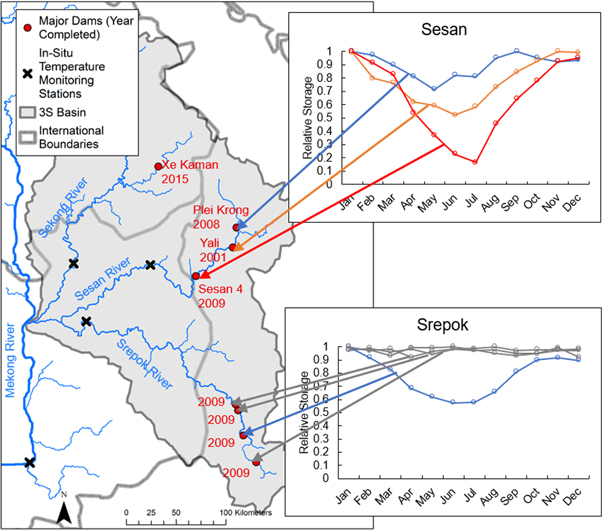
Figure 4. Remote sensing derived operating patterns of major dams in Sesan and Srepok Basins.
Download figure:
Standard image High-resolution image3.3. Other potential drivers of river temperature change
It is clear that there may be other drivers, both natural and artificial, besides dam development that can alter river temperature. Here, we take a closer look at three of these drivers, precipitation and air temperature trends, as well as land cover change, to determine if any of these could have played a role in the cooling effects we observed (figure S.4-supplement). Annual precipitation for all three basins remained relatively constant throughout the 30-year period, except for 1999 and 2000, which were anomalously wet years. This roughly corresponds with the sharp cooling seen in the Sesan Basin, and an excess in runoff could cause water temperatures to decrease. However, the Sekong or Srepok River Basins experienced the same high precipitation and neither showed any signs of river temperature cooling around 2000. Annual average air temperature showed a mild warming trend which is similar for all three basins. Interannual air temperature anomalies are small and appear to have little effect on the annual river temperature anomalies. For example, 1998 was a warm year, yet this is not reflected in the river temperature observations. However, the slightly warming air temperature trend could contribute to the long periods of river warming observed. Land cover data was derived from the Moderate Resolution Imaging Spectroradiometer (MODIS), which has been in operation since 2000. The dominant land cover change in the 3S basin over the last 20 years has been deforestation. The forests of all three basins have been rapidly converted to agricultural lands. Deforestation of this scale is often linked with increasing stream temperatures (Nelson and Palmer 2007, Macedo et al 2013). Given the extent of deforestation occurring in the 3S Basin, it is likely a major driver of stream temperature warming. However, deforestation has been occurring at a fairly steady rate over the past 30 years and is unlikely to be the cause the sharp river temperature declines observed in our study.
3.4. Impact on greater Mekong basin
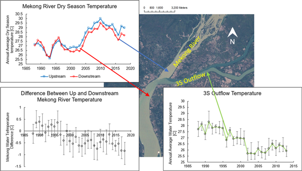
Given that the rivers in the 3S basin are cooling and hydropower dam development is the most plausible driver, a follow up question emerges: How far downstream does this effect propagate? To help answer this, we applied the same Landsat monitoring technique to three more locations, the 3S outlet just upstream of where it meets the Mekong River, and the Mekong River just upstream and just downstream of the 3S confluence (figure 5). At the 3S outlet, we see signs of cooling, but rather than the sharp, discrete decreases observed on the individual rivers, the temperature here slowly decreases over the course of the 30-year period. Given that hydropower dams appear to be the primary source of cooling in the major rivers, it is highly likely that this slow, steady temperature decline represents a cumulative cooling effect experienced by the major rivers upstream of the Mekong River confluence (figure 5). While this cooling trend is fairly prominent at the 3S confluence, it becomes more ambiguous after mixing with the Mekong River. The Mekong River generally experienced warming at this location within the 30-year period, and none of the thermal characteristics appeared to correspond clearly with hydropower dam development in the 3S. However, comparing the temperature of the Mekong River before and after it has mixed with the 3 S, revealed the influence of the 3S on Mekong River temperature (figure 5). Before 2000, the 3S generally appeared to have had a slight warming effect on the Mekong River when the two rivers mixed, with the downstream 0.2 °C–0.4 °C ± 0.31 °C warmer than the upstream. Given the uncertainty, a longer record of historical data would be needed to establish this warming effect more definitively. After 2000, this trend shifts with the 3S appearing to cool the Mekong River, by as much as 0.8 °C ± 0.42 ° C downstream of the confluence. The timing of this shift roughly corresponded with the beginning of operations of the Yali Dam on the Sesan River in 2001. This is where signs of cooling end for now. The cooling signal disappears by the time the water reaches an in situ temperature monitoring station approximately 100 km downstream of the 3S confluence (figure 1).
Figure 5. Landsat based dry season temperature trends of the 3S Basin outflow, and the Mekong River upstream and downstream of the 3S-Mekong confluence. The difference between the upstream and downstream Mekong River temperature is also shown.
Download figure:
Standard image High-resolution image
3.5. Limitations
There are several key limitations with this current study. First, the TIR derived river temperatures are estimates of the water surface temperature and not the average temperature of the water column beneath. Furthermore, the uncertainty in these estimated surface temperatures (±0.35 °C on average) is too high to state in absolute magnitude of water temperature before and after dam development. However, the temperature decreases coinciding with the timing of upstream dam development appear significant compared with normal temperature variations in the 10+ years prior to hydropower dam development. This detected change is supported by the in situ temperature monitoring data for the time period it was available. Further discussion about general limitations in the application of Landsat TIR data to rivers and the steps taken in this study to mitigate those limitations are provided in the supplement.
4. Conclusions
By leveraging a long record of Landsat satellite's thermal observations, we deciphered a river temperature cooling trend in the 3S River Basin that was previously undiscovered due to limited in situ data. We linked these trends with upstream development of major dams by using the varying rates of dam development among the three major sub-basins. The limited in situ data available suggests that this cooling is not limited to the low streamflow of the dry season, but rather extends several months into the wet season, when streamflow dramatically increases (by at least one order of magnitude), further highlighting the magnitude of the cooling. A consequence of this cooling is the stabilization of the seasonal thermal regime, which has immense implications for ecological health downstream (Olden and Naiman 2010). Other possible sources of river temperature change were investigated but ruled out as a driver of these cooling trends. Finally, this cooling effect was tracked downstream and a noticeable impact on Mekong River water temperature was established. While the impact on the greater Mekong Basin is relatively small for now, this could rapidly change as larger and more numerous dams are planned in the 3S Basin, much further downstream than current hydropower dams. Furthermore, major dams planned on the main stem of the Mekong River in Laos and Cambodia also pose major changes to river temperature (WLE 2017). Understanding and preparing for these changes will be critical in the coming decades for downstream fisheries, which currently provide the protein source for millions of people. Unless in situ temperature monitoring efforts dramatically increase, the only way to monitor these changes towards sustainable water resources development will be through the use of satellite remote sensing data, like those used here. Even in the face of overwhelming evidence of the negative environmental impacts that dam development has caused and will cause, there are no signs of slowing dam development in the MRB (Dugan et al 2010, Grumbine and Xu, 2011, Orr et al 2012, Hecht et al 2018, Pokhrel et al 2018).
This study highlights yet another facet of the environment that will be significantly altered by continued hydropower dam construction. One method to offset these environmental changes in the face of seemingly unstoppable dam development in the MRB is to design reservoir operations that explicitly include environmental goals such as maximizing fishery health (Sabo et al 2017). Before this idea can be made operationally feasible, much more research is required into the interconnected environmental systems and societal needs (Holtgrieve et al 2018). What is evident from this study is that hydropower dams in the 3S Basin have a significant impact on river temperature. This effect should be taken into account in future attempts to design reservoir operations that mitigate environmental damages. Beyond designing dam operations, the thermal impact of hydropower dams on downstream reaches needs to be better understood in the MRB in order to minimize the negative effects on the livelihoods of the millions of people who depend on the Mekong River.
Acknowledgments
This work was supported by NASA Earth System and Science Fellowship grant 80NSSC17K0379, NASA Water Applied Science Program (grant NNX15AC63G), and the NSF INFEWS Program (EAR 1740042). Landsat Data products and MODIS Land Cover Data provided by USGS Earth Resources Observations and Science Center and accessed through Google Earth Engine. PERSIANN precipitation data provided by NOAA and accessed through Google Earth Engine. Atmospheric data provided by NCEP/NCAR and accessed through Google Earth Engine.
Data availability
The data that support the findings of this study are available from the corresponding author upon reasonable request.
Author contributions
M Bonnema conceptualized the study, ran the data analyses and wrote the paper. F Hossain also conceptualized the study, analyzed results and reviewed the paper. B Nijssen and G Holtgrieve assisted in reviewing this paper. All the authors helped in discussing ideas, interpreting results and editing the paper.