


Introduction
The purpose of this note is to describe two little-known ice caps in Finnmark and to compare their present area with that shown on the Norwegian topographical survey of 1895–96.Footnote † The two ice caps are the most northerly in Norway. They are situated on the Island of Seiland (lat. 70° 30′ N., long. 23° 30′ E.), which lies immediately to the south of the port of Hammerfest. The island is compact in form and approximately 910 km.2 in area. Morphologically it consists of a plateau which drops from 800 m. above sea level in the west to 600 m. in the east, with a few peaks rising gently 200–300 m. above this level; it is deeply dissected by many glaciated valleys and fjords.
Nordmannsjøkulen (1075 m.), lying in the western part of Seiland, is the higher cap, but is not as extensive as Seilandsjøkulen (981 m.), which lies 5 km. to the east, at the centre of the island.
Seilandsjøkulen
Seilandsjøkulen is of compact but irregular outline (see Fig. 1); at its greatest it measures 4.3 km. from north to south and 4. km. from east to west. It has an area of 11.5 km.2. The highest point is the summit of a narrow rock ridge, which runs from an ice-free plateau to the north. The bulk of the ice occurs to the south and south-west of the summit and on its eastern flank. The south-western ice is enclosed within a perimeter of rock peaks, ranging from 750 m. to 870 m. in height. It appears to be stagnant.

Fig. 1. Seilandijøkzden and Arordmannsjokulen showing the lirnits of the ice in 1896 and 1956.
The main drainage of the ice cap occurs through its southern flank to Bekkarfjorden in south-east Seiland. This flank or lobe contains the greatest area and bulk of the ice and is the only ablation area on the ice cap which can definitely be said to be in a state of active movement. It descends to 500 m. above sea level; elsewhere the ice does not extend below 690 m. As it was the largest area of active ice found on either ice cap in 1956, it was examined in some detail and its outlets were surveyed.Footnote ‡ The ice on the eastern flank of the summit ridge constitutes a much smaller lobe, draining into Gjøfjorden in the north of Seiland.
The southern lobe extends for 3.2 km. from the summit of Seilandsjøkulen, in the form of a segment of a shallow dome. There are two major breaks of gradient occurring on the surface within the general convex long profile, both of which extend the full width of the segment. These are at 780 m. and 650 m. above sea level, and they mark the crest and foot of a slope which descends relatively steeply to a broad, flat bench. Below the bench the ice continues its descent at a steadily increasing angle, to its outlets at 500 m. The ice front abuts against two rock ridges, which run in a north-easterly direction. Both have strongly marked “stoss and lee” cross-sections, suggesting that in the past the basal ice has overridden them, rather than been deflected along the narrow valley, 50 m. in depth, which separates them. The more northerly ridge thrusts like a finger into the ice front, deflecting it into two distinct outlets, the “West” and the “East”. The ice of the West outlet dips into a small lake ponded up behind this ridge. The surface of the lake is covered by a pediment of dead ice, part of which appears to be afloat. The East ice outlet is deflected sharply into the narrow valley referred to above. The stream which flows from it is substantially larger than that which flows from the lake at the West outlet, so it is evidently the more important drain.
The ice in both outlet areas is extensively crevassed, the nature of the crevassing clearly indicating the effects of the deflection. Crevasses also occur at the edge of the 650 m. bench; none were observed elsewhere on Seilandsjøkulen.
Dirt bands occur with great frequency and regularity of distribution in the outlet areas; they contour the descending ice except where the effect of the deflection is to pull them locally out of the horizontal plane. The mean of a series of measurements gave 0.5 m. for the thickness of ice between two adjacent bands. Three dirt cones were found near the outlets; they were elongated along minor surface drainage runnels which carried unusually large amounts of dirt-band outwash. Their mode of origin appears to be that suggested by Swithinbank.Reference Swithinhank 1 An unusual item found within the very fine, dark silt of which they were made, was a single bone from the vertebral column of a reindeer.
Observations made in 1956 suggested that the firn line lay approximately along the break of slope at 780 m., with subsidiary accumulation remaining on the 650 m. bench below, but the party left Seiland three weeks before the first autumnal snowfall was expected. The author has subsequently seen an oblique air photograph (Fig. 2, p. 252) of the cap taken in late August 1953, i.e. nearer the close of the mean annual ablation period. It shows that ablation had occurred in large areas above 780 m. It seems probable, therefore, that in a warm summer almost the entire cap loses its snow cover. The bulk of the ice has a southerly aspect. However on Nordmannsjøkulen an ice lobe extending to 1072 m. above sea level and having a northerly aspect had lost all its snow cover in 1956 at a time when only negligible areas of blue ice could be seen above 780 m. on Seilandsjøkulen. The latter ice cap is somewhat protected from the prevailing warm south-westerly winds by Nordmannsjøkulen and ice-free mountains to the south of it, which may be a partial explanation of this anomaly.
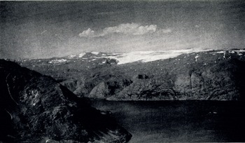
Fig. 2. Seilandsjøkulen from the south-east, showing the southern lobe from the summit of the cap to its outlets. The lower part of the northern lobe can be seen in the right centre of the picture.
Fig. 1 indicates that Seilandsjøkulen has contracted considerably during the 60 years 1896–1956, its area diminishing by about 56 per cent. The front of the southern lobe has retreated 1500 m., revealing five ridges running from south-west to north-east and including the two mentioned above. The three more southerly ridges are covered with ground and ablation moraine, but the two northerly, although in no way markedly different topographically, are bare, save for some scattered erratic boulders. This suggests that down-wasting of the ice has been more rapid in the recent past, the finer material being carried away by increased pro-glacial run-off. Evidence of the depth of ablation in the melting season of 1956 was found on one of the northerly ridges. Here, at a point six metres above the then level of the ice, a deposit of fine silt had been striated by over-riding ice. The edges of the grooves so formed were only slightly modified by running water. A summer”s rain-wash would have destroyed them.
Ice lobes and tongues to the east and west of the southern lobe have also retreated considerably, but here the relationship of the present mountain topography to the contours on the map of 1896, suggests that at that date the ice was already very thin. The most extensive contraction has been that of the lobe to the north-east of the summit; its area has diminished by 75 per cent and its surface long profile is now concave, whereas it was convex in 1896. The considerable diminution of this northern lobe contrasts sharply with the case of Nordmannsjøkulen (described below), where the only large body of ice remaining occurs on the north side.
A general conclusion is that in 1896 Seilandsjøkulen was greatly over-expanded in area in relation to its annual increment of nourishment. It has consequently contracted and is more compact in form. It is probable that it now receives only a very limited amount of nourishment each year, insufficient to maintain even its present small area.
NordmannsjøkulenFootnote *
Nordmannsjøkulen, the highest point on Seiland, is a mountain massif isolated as a distinct peninsula by two long fjords, Kufjorden and Gjøfjorden, and a deep valley which continues the north-south trend of Gjøfjorden. The 800 m. plateau occurs on its fringes as a series of broad, elongated ridges, between which the ice has scoured deep, radiating valleys. The present “ice cap” was the centre of dispersal, and rises above the plateau as a gentle pyramidal mountain. The survey of 1896 indicates that it was buried by ice, only a small area of the summit rocks showing through; the ice also extended along certain of the broad ridges.
To-day only three very limited bodies of ice remain on the southern and south-western flanks; they occupy shallow hollows in the mass of the rock, and appear to be residual and very thin. The northern flank is still buried by a broad half-dome of ice (the “Northern Lobe”), which extends from 1072 m. (i.e. immediately below the summit rocks) to the level of the plateau at 800 m. It has an area of approximately 3 km.2, and its longitudinal profile is gently convex. The ice has no clearly defined lower edge, but thins into irregular pediments of firn. In 1956 the whole lobe underwent net ablation; no crevasses were observed. Like the ice on the southern flanks, it appears to be residual.
To the east of the summit, a small extension of the Northern Lobe inclines steeply into an amphitheatre which is contained by cliffs over the Gjøfjord valley. The amphitheatre is drained by an ice fall down a narrow declivity. The ice fall is approximately 1000 m. in length, 140–200 m. in width, and 250 m. in height. It is crevassed throughout its length. After one-third of its descent it is broken by a short ice-cliff, below which much shattering occurs, larger cavities extending to the bedrock. At its terminus, the ice fans out into a tongue of firn, and a short distance below the declivity opens into a valley. The opening is partially blocked by an end moraine 200 m. in length, and 6-10 m. in height. The ice descending into the amphitheatre and below it to the ice-cliff, is still flowing, although its sources lose all their winter accumulation by ablation in the summer. Certain narrow transverse crevasses were observed to open, and others to close, within a period of seven days.
It seems that Nordmannsjøkulen can no longer be strictly considered an ice cap, but rather a mountain with limited residual ice-masses on its flanks.


